Hurricane Delta On Track To Make Landfall In Already-Damaged Southwestern Louisiana

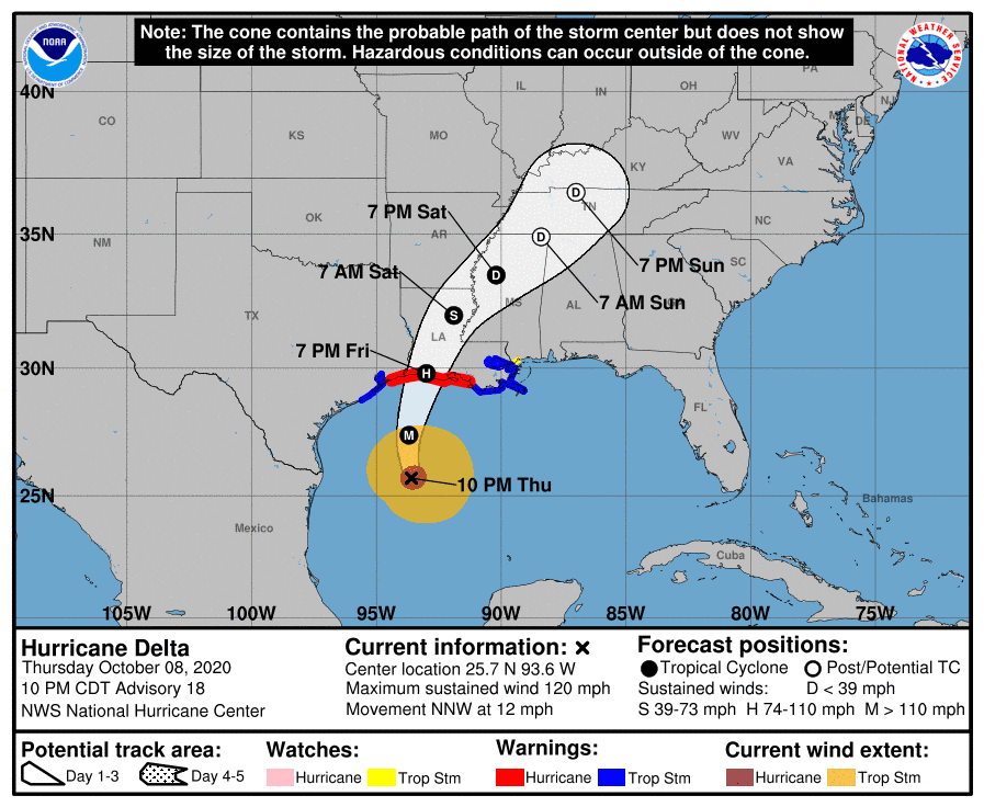
Hurricane Delta restrengthened into a major hurricane on Thursday as it steadily made its way toward the Louisiana coast. The hurricane will make landfall Friday afternoon in southwestern Louisiana, very close to where Hurricane Laura hit back in August. Destructive winds, a life-threatening storm surge, and flooding rains are likely along Delta’s path into Louisiana. The effects of this hurricane will be exacerbated by lingering damage and structures weakened by the previous hurricane.
This has been a tenacious storm since the day it formed. Delta managed to strengthen into a powerful and tiny category four hurricane before crashing into Cancun on Wednesday morning. The storm weakened over land, but warm water and favorable environmental conditions over the southern Gulf of Mexico helped Delta recombobulate and begin to strengthen again. The hurricane even developed a clear eye for a little while on Wednesday evening.
 |
| Source: National Hurricane Center |
The 10:00 PM CDT advisory from the National Hurricane Center bumped Delta’s winds up to 120 MPH, making it a major hurricane again. The storm’s winds will likely tick down a bit as it approaches landfall in southwestern Louisiana on Friday afternoon, but this is a powerful storm that’ll do quite a bit of damage to an area still trying to recover from Hurricane Laura.
Communities around the point of landfall will experience the strongest winds and the greatest storm surge, but make no mistake—this is a large hurricane and it’ll have wide-reaching impacts in the region.
As expected, Hurricane Delta’s wind field is larger than it was Wednesday. The storm’s growth will expose a larger region to damaging winds and a life-threatening storm surge that could measure as high as 11 feet above ground level near the point of landfall. The National Hurricane Center’s latest advisory measured Delta’s tropical storm force windfield at about 320 miles wide, with hurricane force winds stretching 80 miles across the eye.
Widespread power outages—numbering in the hundreds of thousands—are likely across Louisiana as Delta makes landfall and pushes inland. Trees weakened by Hurricane Laura will struggle to withstand Hurricane Delta, endangering homes that sit beneath large trees and tree limbs.
 |
| Source: Weather Prediction Center |
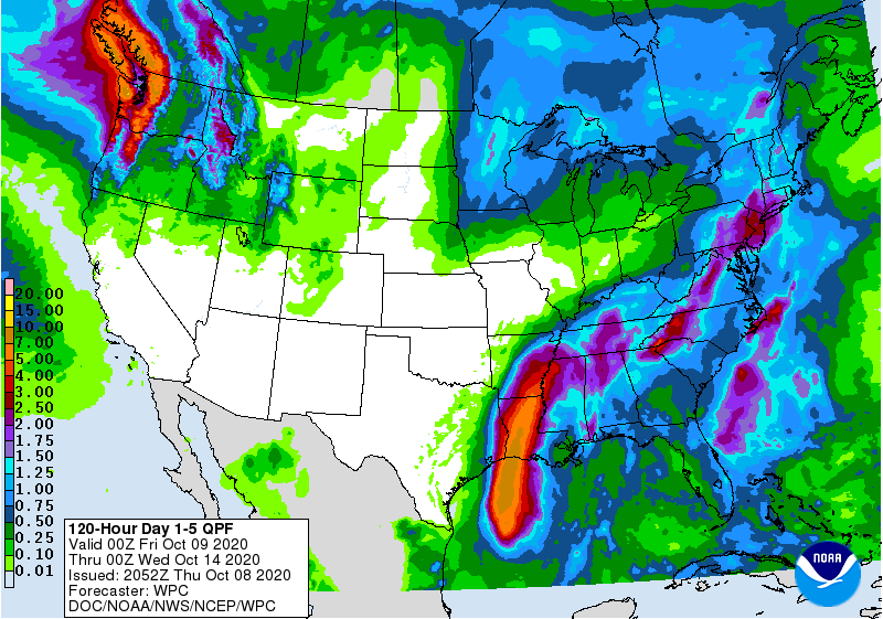
Flash flooding is also a major threat along Delta’s path inland. Communities from southern Louisiana to southern Arkansas could see more than five inches of rain through Saturday. This much rain falling this quickly will lead to flash flooding in vulnerable areas.
Even though I’m confident that you already know this if you’re reading my blog (thank you, by the way!), it feels like a requirement to stick this in here, so here goes..
The leading cause of death during landfalling tropical cyclones in the U.S. is flash flooding from excessive rain. It only takes a small amount of water to lift up a vehicle and carry it downstream. It’s impossible to tell how deep the water is before it’s too late, and sometimes the floodwater can obscure that the road itself is washed away. It’s not worth it. Find another route or stay put if you can.
[Satellite Image: NOAA]
You can follow me on Twitter or send me an email.
Please consider subscribing to my Patreon. Your support helps me write engaging, hype-free weather coverage—no fretting over ad revenue, no chasing viral clicks. Just the weather.

