
It's been a little while since we've had noteworthy active weather across the United States. A steep trough in the jet stream will spawn a potent low-pressure system over the Plains on Wednesday, setting the stage for a widespread risk for severe thunderstorms in the south while snow and ice coat communities from Kansas to Michigan.
The Setup
 |
| SOURCE: WPC |
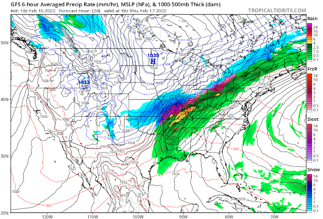
That's one messy map.
A robust low-pressure system will develop on the southern Plains early Thursday morning. The system will get its act together in a hurry, speeding across the Midwest toward the Great Lakes before reaching New England during the day on Friday.
We're going to see a little bit of everything with this storm, with heavy rain and severe thunderstorms to the south to a threat for snow and ice to the north.
The Wind Threat
The most widespread issue with this system will be strong, gusty winds.
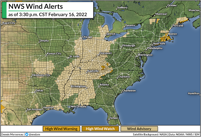
Wind advisories and high wind warnings are in effect for a large swath of the country from Alabama to Michigan, and it's likely that these alerts will spread east over the next couple of days.
The system will spread gusty winds across much of the eastern United States through Friday. Wind gusts of 35-45 mph will be common, with much higher gusts in some spots. The greatest potential for damaging winds exists near the eastern Great Lakes. Downed trees and power outages are likely in areas that catch the strongest gusts.
The Severe Threat
Here's something we haven't had to deal with in a while, and it's directly related to those gusty winds.
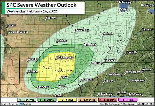
Warm(ish), humid air on the southern side of the low-pressure system could fuel several days of severe thunderstorms across the south, beginning with the southern Plains on Wednesday.
A slight risk for severe weather is up for parts of Texas, Oklahoma, and Arkansas on Wednesday. All modes of severe weather are possible here, including a threat for tornadoes across northern Texas and southern/eastern Oklahoma.
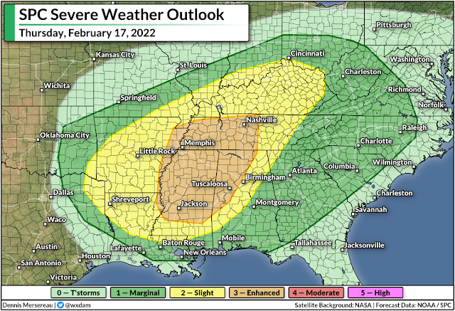
The storm threat will shift east on Thursday as the low pulls toward the Great Lakes. Severe thunderstorms could develop along and ahead of the cold front as it sweeps through the southeastern states. This is the first risk for severe weather we've seen in some areas, especially in the Carolinas, since last year.
The greatest threat from these storms will be damaging wind gusts. We'll see gusty winds with or without thunderstorms—it won't take much of a downdraft for a thunderstorm to shove even higher winds down to the surface, hence the widespread severe risk through Friday morning.
A significant portion of Thursday's severe weather risk will unfold overnight Thursday into Friday. Nighttime severe weather is especially dangerous because it's easy to miss warnings after you've tuned out or you've gone to bed.
Take a moment today to check your cell phone and ensure that wireless emergency alerts are activated for tornado warnings. It's easy to switch all the alerts off after one ill-timed activation for an AMBER Alert, but those tornado warnings are proven lifesavers and can catch your attention when you're focused on anything but the weather.
It's also worth noting that the widespread heavy rain and thunderstorms could lead to a risk for flooding along and near the track of the low itself. Flood watches are in effect from southern Missouri to western New York, with several inches of rain expected for most areas. That typically wouldn't be a problem on its own, but the rain on top of snowmelt will lead to localized flooding issues, and ice jams could lead to swollen streams and rivers overflowing their banks.
The Snow/Ice Threat
Cold air to the north of the low will allow precipitation to fall as snow and ice, especially in the Midwest and around the Great Lakes. This won't be a widespread winter storm like the storm we saw a few weeks ago, but the quick thump of snow and ice could cause issues in some areas.
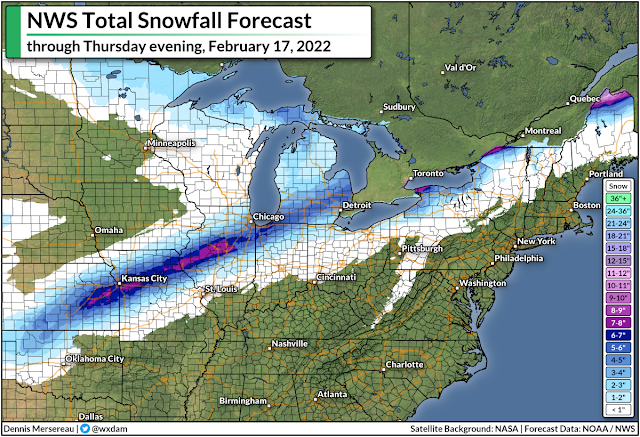
The National Weather Service's latest forecast calls for a narrow but potent swath of snow to fall from northern Oklahoma to northern Maine. The heaviest snow is likely across parts of Kansas, Missouri, and central Illinois, including the Kansas City metro area. We could see more than half a foot of snow across these areas. Several inches of snow could fall on the Chicago and Detroit metro areas, as well.
 |
| SOURCE: digital.weather.gov |
As we often see around this time of year, warm air nudging in above the cold air at the surface will force some of the wintry precipitation to fall as freezing rain. We could see a light coating of ice along and north of the storm's track, with the heaviest totals possible in central Illinois and small parts of western New York and northern Maine.
This shouldn't be a debilitating ice storm by any means, but a glaze to one-tenth of an inch of ice accretion is enough to make travel dangerous and potentially bring down any weak tree limbs. The combination of the weight of the ice and gusty winds could lead to power outages.
[Model Graphic via Tropical Tidbits]
You can follow me on Twitter or send me an email.
Please consider subscribing to my Patreon. Your support helps me write engaging, hype-free weather coverage—no fretting over ad revenue, no chasing viral clicks. Just the weather.
Please consider subscribing to my Patreon. Your support helps me write engaging, hype-free weather coverage—no fretting over ad revenue, no chasing viral clicks. Just the weather.


0 comments: