
You didn't think we'd get off that easily, did you?
After a rough round of severe weather this week broke a remarkable stretch of dulcet autumn weather across the United States, the tropics felt the need to get the last word.
A tropical disturbance in the southwestern Atlantic Ocean has a decent shot at becoming this hurricane season's 14th named storm, and it could have its sights set on Florida and the East Coast in the days after this week's election.
Possible Mid-Week Headache
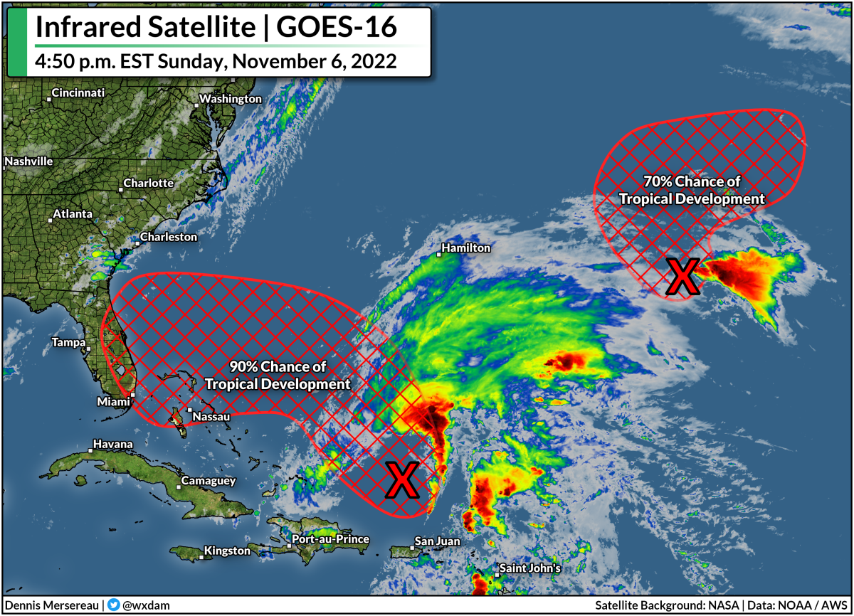
It doesn't look like much on satellite right now—it more closely resembles a gallbladder than a tropical system this evening—but environmental conditions will gradually become more favorable for development over the next few days. The National Hurricane Center gives the disturbance a 90 percent chance of turning into a tropical or subtropical storm by the middle of the week.
Regardless of its ultimate development, most models bring the disturbance and/or system into Florida before it interacts with a cold front and turns north to track up the eastern seaboard.
Some models are developing the system more than others—the GFS model, for instance, is trying to turn it into a strong tropical storm or even a hurricane before hitting southeastern Florida on Wednesday or Thursday. Even though that's probably an outlier at this point, there's a growing consensus that we'll probably have a named storm on our hands before long.
Tropical vs. Subtropical: What's The Difference?
Honestly, just as an aside, I can't stand talking about "subtropical storms" because the term becomes a distraction. Everyone loves a good process story (me included!) and it sometimes crowds out the actual impacts of the storm.
The distinction between a tropical system and a subtropical system is mostly technical. It's helpful to think about low-pressure systems as existing on a spectrum instead of fitting into neat little boxes. A subtropical system has characteristics of both a tropical cyclone and an extratropical cyclone, or the 'everyday' type of low-pressure system we deal with on a regular basis.
A tropical cyclone features warm air throughout the storm and it derives its energy from thunderstorms packed around the center of the cyclone. An extratropical cyclone, on the other hand, features cold and warm fronts, and typically gathers its strength from upper-level winds.
Subtropical cyclones sort of meet in the middle—there's some cold air in there, it's a little asymmetric, it gets some of its energy from thunderstorms and a touch from upper-level winds. Again, it's mostly technical! But the bottom line is that a subtropical storm is indistinguishable from a 'normal' tropical storm when you're in the thick of it, so the NHC issues forecasts and warnings on it just the same.
Lots Of Rain From Miami to Moncton

If you live along the East Coast, it's a good idea to check if you've got supplies to deal with power outages. It's also important to mentally review your plans for what to do in the event of flooding at home or if any of your daily routes encounter water-covered roads. The number-one danger in any landfalling storm is freshwater flooding from heavy rainfall. It only takes a little bit of water to lift up a vehicle and carry it downstream.
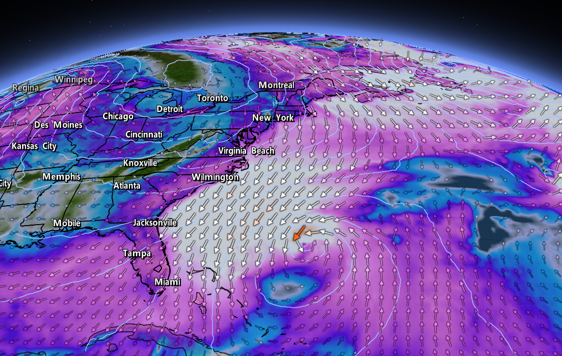
Taking a look at the Weather Prediction Center's 7-day precipitation forecast shows the potential for heavy rain up and down the East Coast over the next week. The system will interact with a Colorado low heading toward the western Great Lakes, helping to produce widespread rainfall across the eastern U.S. toward the latter half of the week. There's a chance we could see gusty winds and pretty heavy rainfall for parts of New England and the Canadian Maritimes by the end of the week.
You'll notice on that map a few sections up that there's another disturbance way out in the oceanic boondocks that could develop into a tropical storm over the next couple of days, but don't worry about it—it's only a concern for fish and ships.
Upcoming Storm Could Make A Terrible Season 'Average'

The next two names on this year's list for the Atlantic basin are Nicole and Owen.
If either one of these systems develops, it would become the 14th named storm of the 2022 hurricane season, making this season exactly average in terms of number of named storms. A typical Atlantic hurricane season sees 14 named storms, 7 hurricanes, and 3 or 4 major hurricanes. As of this post, the current count is 13/7/2.
It's been a weird year. Just about all forecasters expected another very active hurricane season based on La Niña continuing in the eastern Pacific Ocean. Things didn't work out that way. It takes lots of ingredients for tropical cyclones to come together, and even though the overall pattern was favorable, individual ingredients kept misaligning and throttling most opportunities for storms to form.
We saw an unprecedented gap in storms between Tropical Storm Colin dissipating on July 3rd and Tropical Storm Danielle forming on September 1st.
Calling this season average feels like a grim understatement. The old mantra of "it only takes one" sure came through this year.
Hurricane Fiona smacked into the Maritimes as one of the region's worst storms in living memory. Just a week later, Hurricane Ian hit Florida as a high-end category four and the state's deadliest hurricane since the Labor Day Hurricane of 1935, killing almost 150 people.
Mariah is on the radio and the stores are bursting with glittery decorations, but hurricane season doesn't 'officially' end until November 30th and we can even see the occasional stray storm wander into December. Don't let your guard down yet.
[Top image created using WSV3]
You can follow me on Twitter, Facebook, or send me an email.
Please consider subscribing to my Patreon. Your support helps me write engaging, hype-free weather coverage—no fretting over ad revenue, no chasing viral clicks. Just the weather.
Please consider subscribing to my Patreon. Your support helps me write engaging, hype-free weather coverage—no fretting over ad revenue, no chasing viral clicks. Just the weather.


0 comments: