
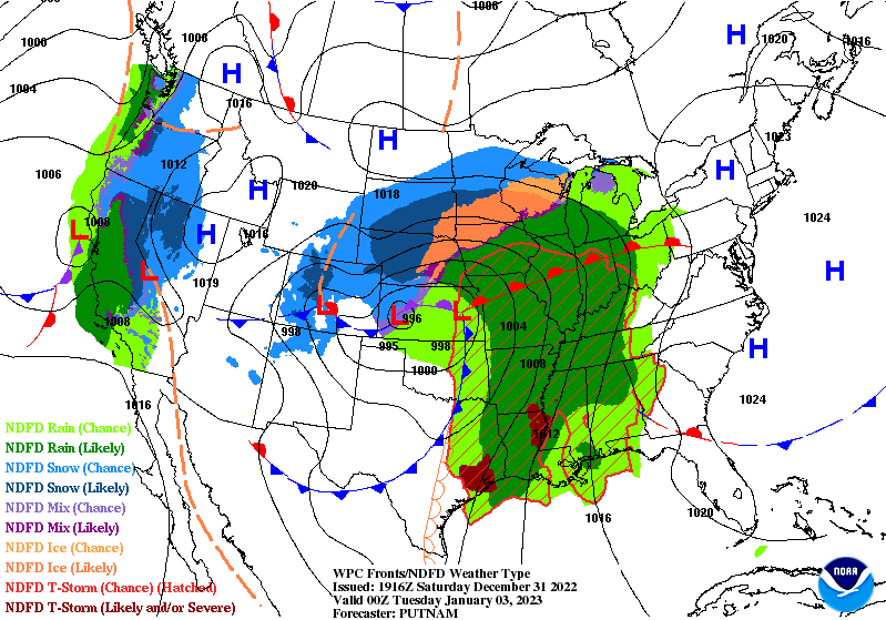
A developing winter storm will tick almost every box on the hazards checklist to start the first week of the new year as a low-pressure system strengthens over the center of the country.
The system is over California right now, bringing plenty of much-needed rain to lower elevations and very heavy snowfall to the mountains. This low will traverse the Rockies this weekend, eventually emerging over the Plains on Monday as a fast-developing Colorado low.
We'll see widespread winter weather across northern sections of the Rockies and the Plains through Tuesday, with several feet of snow falling at the peaks and a decent, shovelable snowfall for areas like Denver, Boulder, and Cheyenne. Freezing rain and sleet are possible closer to the track of the low.
Snow and a wintry mix will continue into the Upper Midwest as the storm peaks in strength as it pushes into the Great Lakes on Tuesday.

Southerly winds pulling into the storm will drag warm, humid air deep into Canada as the low strengthens and moves through, bringing very warm temperatures to just about everyone in the eastern half of the U.S.
The calendar may say January, but the thermometer is going to scream April. Tuesday's highs will climb into the 70s as far north as West Virginia, with 60s reaching western New York—still buried under many feet of snow from last week's blizzards.
A few inches of rain could fall through early next week with this system. The rapid warmup and arrival of heavy rain could lead to flooding in areas where the ground is frozen or there's still significant snowpack from last week's storm and lake-effect bonanza.

Farther south, the system's cold front plowing into that warm and humid airmass will trigger a round of severe thunderstorms across the Deep South on Monday.
The greatest threat appears centered on the Arklatex region, with the threat stretching out to include Little Rock and Shreveport. These areas could see the threat for "potentially significant damaging gusts and a couple of strong tornadoes," the Storm Prediction Center said on Saturday.

Colder air will move in for a couple of days behind the system, but it's not going to last too long or get too cold. In fact, winter's deepest chill seems like it wants to chill out on the northern Plains for the next couple of weeks, sparing the rest of us with milder conditions through the first half of the month. (And even there it'll be warmer than normal.)
The Climate Prediction Center's latest outlook through January 13th tells the tale—decent odds of warmer-than-normal temperatures for almost everyone. Ahh, winter.
[Top Map: NOAA/WPC]


0 comments: