March 31, 2023

Central U.S. Faces First 'High' Risk Severe Weather Day In Years


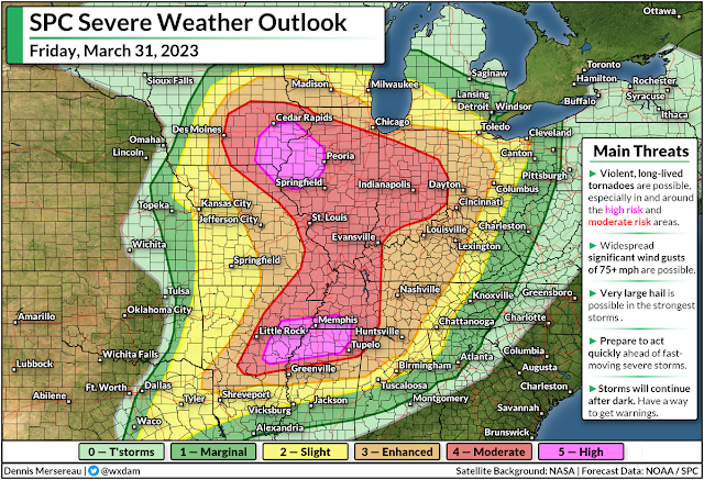
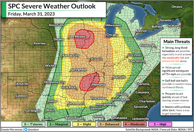
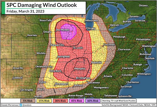
The Storm Prediction Center (SPC) expects a widespread and significant severe weather outbreak across much of the central United States on Friday, including the potential for "violent, long-lived tornadoes," as well as destructive wind gusts of 75+ mph and very large hail in the strongest storms.

This is the first high risk issued by the SPC since March 25, 2021, a day that saw multiple violent tornadoes tear across Alabama and Georgia. This also appears to be the first 'double' high risk—with two distinct bullseyes—in over a decade.

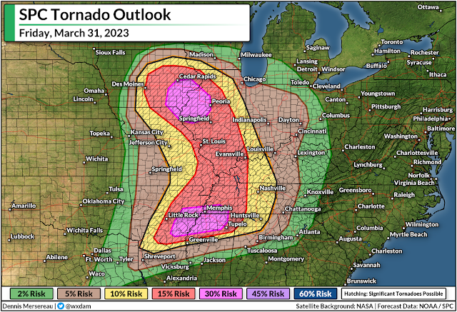
Friday's upgrade to high risk is tornado-driven, according to SPC forecasters, with a better-than-even chance of violent, long-lived tornadoes in eastern Iowa and northwestern Illinois—including Cedar Rapids, Davenport, and Peoria—as well as a swath of the Mid-South, centered around the Memphis metro area.


Areas under the high risk are just where dynamics are approaching peak favorability for significant tornadoes. We still have a very large swath of the country under a moderate risk, including almost the entire state of Illinois, most of Indiana, and large portions of every state bordering the Mississippi River down to Greenville.

Communities in and around the moderate and enhanced risk areas could also see widespread destructive wind gusts, significant tornadoes, and large hail. Many major cities and transportation hubs are included in this sprawling threat for severe weather.

"Particularly Dangerous Situation" (PDS) tornado watches were issued for most of the high risk and moderate risk areas by midday on Friday, with the threat growing through the afternoon hours and spreading east into the overnight.


This wide-ranging severe weather outbreak will push east Friday night into early Saturday morning as the powerful Colorado low responsible for this outbreak tracks across the Great Lakes into Ontario.

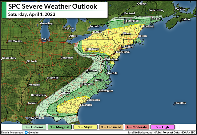
Another round of severe weather is likely on Saturday up and down the East Coast, with damaging winds and isolated tornadoes possible from near the Quebec border down through the Florida Panhandle.

Make sure you've got a way to get warnings and seek safe shelter, and give your friends and family a heads-up if they're in the area.


You can follow me on Facebook, Mastodon, Twitter, Instagram, or send me an email.

Please consider subscribing to my Patreon. Your support helps me write engaging, hype-free weather coverage—no fretting over ad revenue, no chasing viral clicks. Just the weather.


March 30, 2023

Widespread Severe Weather Expected Friday Across The Central U.S.


A classic springtime system rolling across the northern U.S. will lead to a widespread risk for severe weather across the middle of the country on Friday.

We've had some potent severe weather already this year—including a devastating EF-4 tornado in Mississippi last week—but this is the widest-ranging severe storm risk we've seen so far this season.

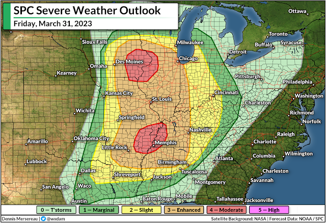
The Storm Prediction Center (SPC) expects severe thunderstorms on Friday from east-central Texas all the way into central Wisconsin, stretching as far east as the Ohio River Valley through the overnight hours into Saturday.

A strong Colorado low sweeping across the Upper Midwest on Friday will sow the seeds for this potential severe weather outbreak. Unstable air streaming north into the low will provide the instability, and powerful upper-level winds will supply the wind shear needed to turn thunderstorms severe.

Source: TwisterData.com

As with most classic springtime severe weather outbreaks, we'll see the hazards play out in two distinct rounds. The initial thunderstorms have the best opportunity to grow into supercells capable of producing strong, long-lived tornadoes, as well as large hail and damaging winds.

These supercells are most likely in and around the two moderate risk areas: near the center of the low in Iowa, and near the greatest instability and wind shear over the Mid-South.

As the day wears on, a lengthy squall line will develop along an approaching cold front, transitioning the threat to widespread damaging wind gusts (60+ mph) and the potential for fast-spawning tornadoes in the kinks along the leading edge of the line. This line will push east late Friday through the overnight hours.


A large area falls under an enhanced risk for severe weather, or a 3 out of 5 on the scale measuring the potential extent of powerful thunderstorms. Two separate areas are under a moderate risk, or a 4 out of 5 on the scale, including eastern Iowa and northwestern Illinois, as well as the Mid-South centered around Memphis.


Strong, long-lived tornadoes are possible throughout most of the Mississippi River Valley between Dubuque, Iowa, and Clarksdale, Mississippi, with the potential for significant tornadoes pushing east into central Tennessee and northern Alabama.


Tornadoes get top billing on red-letter severe weather days, of course, but damaging wind gusts—potentially reaching 75+ mph—are far and away the most immediate threat to any one location. These winds can cause as much damage as a tornado, just over a wider area.

Keep a close eye on watches and warnings if you live in the region, and let your friends and family know to do the same if they're under any severe weather risk on Friday. Have a plan in place to seek sturdy shelter in a hurry if a warning is issued for your location, whether you're at home, work, school, or out running errands.

The threat for severe weather will shift east on Saturday, albeit on a much weaker scale as the low-pressure system lifts into Quebec. Damaging winds and a couple of tornadoes will be possible across parts of the southeastern states, as well as a damaging wind threat in any storms that pop up across the eastern Great Lakes.

Another storm next week could produce significant severe weather across many of the same areas expecting bad storms on Friday. It's that time of year. Stay ready, and stay alert.


You can follow me on Facebook, Mastodon, Twitter, Instagram, or send me an email.

Please consider subscribing to my Patreon. Your support helps me write engaging, hype-free weather coverage—no fretting over ad revenue, no chasing viral clicks. Just the weather.


March 13, 2023

Another Atmospheric River Hits California As New England Deals With A Nor'easter


Two major storms will bookend the country on Tuesday, bringing more flooding rains and prolific snows to California while New England deals with its strongest nor'easter of the season.

The Setup

A jet stream firmly parked over the southern half of the United States will set the stage for the two major systems we'll have to deal with over the next couple of days.

Out west, upper-level winds will funnel a rich plume of moisture straight into California. (Stop me if you've heard this one before.) This latest atmospheric river will fuel widespread heavy rains at lower elevations and very heavy snows for the Sierra Nevada.

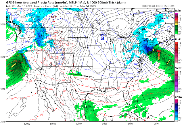
Back east, the combined lift of a trough digging across Eastern Canada and that strong jet stream over the southeastern U.S. will lead to the rapid development of a low-pressure system off the Mid-Atlantic coast late Monday evening.

This low will spin itself up in a hurry, likely meeting the criteria for bombogenesis, or a "bomb cyclone" as you'll probably hear it termed. This just means that the storm's minimum pressure will deepen very quickly, leading to wicked winds and widespread heavy snowfall across much of New England.

More Flooding For California

A weather alerts map of California today looks like a toddler went at it with a fresh pack of Crayola and a vivid imagination. The state is blanketed with flood watches, wind advisories, high wind warnings, and winter storm warnings for the mountains.

Source: NWS

Wind gusts could reach 50 mph for much of the northern half of California through Wednesday, with gusts up to 70 mph possible along the coastline and elevations above 1,000 feet. Those winds could easily lead to downed trees and power outages, especially with soils soaked from all the rain over the past couple of weeks.

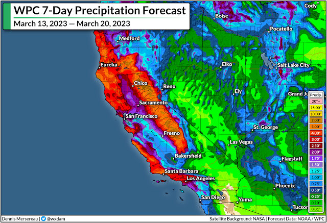
There's plenty more rain where that came from. The latest forecast from the Weather Prediction Center paints widespread rainfall totals of 3-5 inches along the coast, with up to 2.5 inches in the Central Valley and higher totals up north. Much of that precipitation in the mountains will fall as snow, with five feet of additional snow possible above 8,000 feet. 


This latest slug of rain and snow will add further stress to the region's waterways, many of which already spilled over their banks with the round of precipitation a few days ago.

As always, stay alert for flooding and be prepared to change your travel route if you come across a flooded road. It's impossible to tell how deep the water is until it's too late, and it only takes a few inches of moving water to lift a vehicle and carry it downstream. California's hilly terrain increases the odds that there may not even be a roadway left under the floodwaters.

Heavy Snow And High Winds For New England

Meanwhile, the East Coast will soon deal with a storm that could be its most significant thump (in fact, one of its only bouts) of wintry weather this year.

A classic nor'easter will spin up off the East Coast tonight and roar through early Wednesday morning, targeting much of New England with heavy snow and high winds for the day Tuesday.


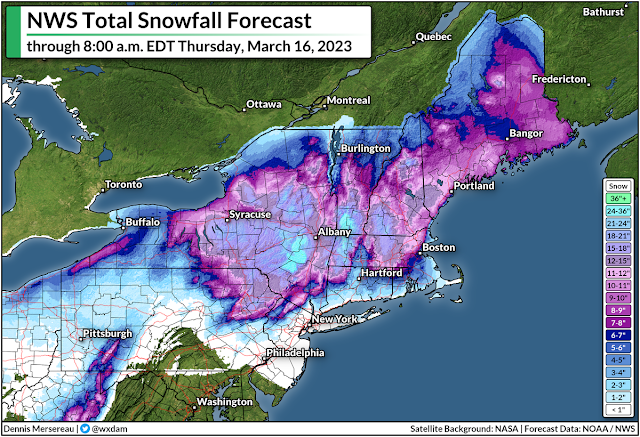
The storm will really get cranking early on Tuesday morning, plastering almost everyone from northeastern Pennsylvania to coastal Maine with double-digit snowfall totals by the time the storm is over on Wednesday.

Most of the snow will fall north and west of I-95, sparing Philly and New York from much more than a dusting at best. Higher elevations in upstate New York could see up to two feet of snow.

Boston is going to be right on the borderline between a nuisance and a solid storm, with about 6-8 inches of snow in the forecast right now—with much lower totals just east and much higher totals just west. It wouldn't take much of a nudge in the storm's ultimate track to push that fine line in either direction. I don't admire local meteorologists up there right now.

Strong winds of 50-60 mph are likely during the storm, which will lead to tree damage and power outages for many location. This is going to be a wet, sloppy snow, to boot, which will weigh down trees and power lines and make damage and outages even more likely. Coastal flooding is also possible.

Heavy snowfall rates and high winds will lead to reduced visibility during the height of the storm, with whiteout conditions possible at times. If you have to travel through the area, it'd be a good idea to get where you need to go by Monday night and plan to stay put for a couple of days. 

[Top Image: Tropical Tidbits]


You can follow me on Facebook, Mastodon, Twitter, Instagram, or send me an email.

Please consider subscribing to my Patreon. Your support helps me write engaging, hype-free weather coverage—no fretting over ad revenue, no chasing viral clicks. Just the weather.