April 25, 2023

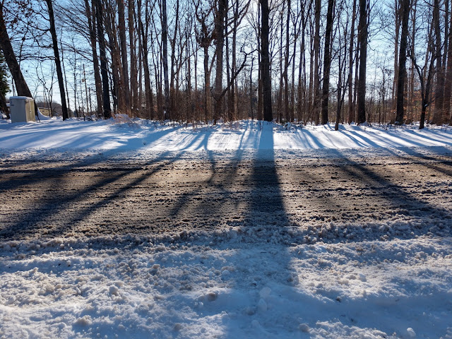
North Carolina's snowy season is over—not that we had one this year


April 24 is a milestone in North Carolina's everlasting battle against wintry weather. 

That fateful Sunday back in 2005 was the latest on record we've seen measurable snow in a major city in North Carolina.

An observer at Asheville Regional Airport recorded 0.1" of snow on that date 18 years ago, a mere dusting among dustings that stands as the latest in the year in modern times we've seen a verified snow measurement in one of the state's big cities. 

Passing this marker in winter weather history doesn't seem to matter much this year, though, seeing as we just witnessed a near-historic snow drought across North Carolina.

A Rare Near-Snowless Winter Across North Carolina

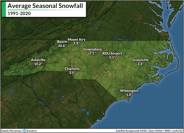
Despite our reputation for falling to pieces the moment someone spots the first flake, it snows just about every year in North Carolina.


Even folks down by the coast sweep away an inch of snow every year or so. Once you're west of Interstate 95, it's actually pretty unusual not to see at least a dusting of snow every year, making this winter's lack of wintry precipitation all the more conspicuous. 

Every weather station in a shade of blue on the map below actually managed to record measurable snow (≥ 0.1") at some point this past winter:


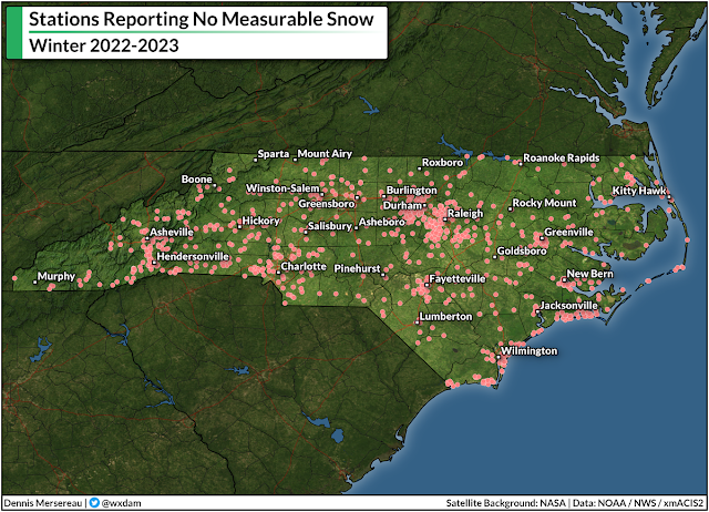
...and every weather station in red on the map below recorded no measurable snow this past winter:


Almost all of this year's accumulating snow remained in the mountains, while a short-lived dusting managed to survive into pockets of the northern piedmont toward the end of March.

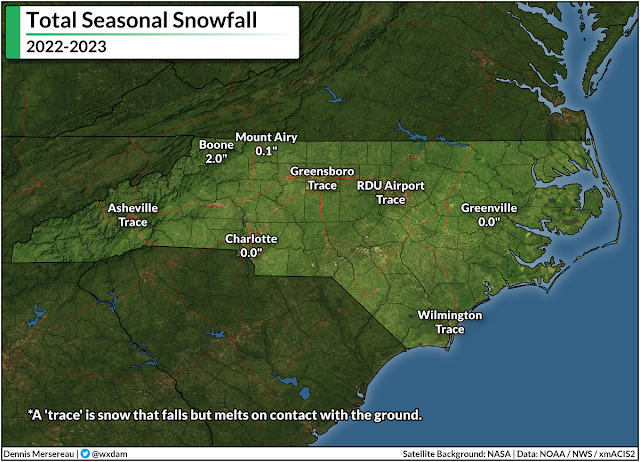
The most snow we saw at lower elevations was a "trace," which occurs when snow falls but melts on contact with the ground. Recording a trace gives meteorologists the ability to note that it snowed even though it didn't accumulate.


If you look at how folks drive and react to any predicted amount of snow, you'd think that every winter storm was our very first one. While we're far enough south that winters are generally tolerable to the warmth-inclined, we're also just high enough in latitude to get clipped by snow and ice storms on a regular basis.

Our major cities each benefit from generous weather records that stretch back to the mid-1940s or earlier, a depth that gives us solid frames of reference for what's normal and how fast our "normal" is changing these days.

Asheville, for instance, has seen measurable snow every winter for the past 70+ years except for just four. With just a trace of snow recorded at the airport, this year ranks among those four. Boone has recorded snow every single winter since 1928; however, the 2.0" that fell there this winter was the lowest out of nearly a century of routine observations.


It's a similar story in our low-elevation metro areas. The big goose-egg measured in Charlotte this winter was one of just 11 winters where no measurable snow fell. Greensboro's trace of snow made this the sixth winter since 1928 where we couldn't even muster a dusting.

The lack of snow isn't for a lack of precipitation, either. Most stations west of I-95 saw slightly below-average precipitation, only by an inch or so. The mountains and piedmont managed to avoid drought all winter, with "unusual dryness" only starting to creep into northern sections around Rockingham and Caswell Counties here at the end of April.

It could have snowed. It should have snowed. But it didn't snow because it was just too warm to snow.

Record Winter Warmth

Calling the previous season "winter" even feels like an overstatement. It was pre-spring. Spring Junior. Aside from the epic cold snap that nearly wrecked our power grid in the days leading up to Christmas, this winter put a capital M in Mild.

The most "winter" we experienced last season was a lobe of the polar vortex that descended upon the United States right around Christmas. Temperatures plummeted into the single digits for much of North Carolina on Christmas Eve.
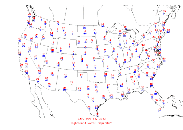
Highs and lows on December 24, 2022. (NOAA)

Such a spell of cold weather isn't unprecedented here, but a series of maddening failures and poor decisions on Duke Energy's part plunged hundreds of thousands of North Carolina homes into the dark on those coldest mornings, a series of self-imposed blackouts designed to prevent cascading damage to the power grid as a result of sub-standard power generation.

Other than that little hiccup...it just never really got all that chilly after Christmas.

This was still a capital-M Mild winter even when you factor in the atmosphere over northern Canada taking a brief sojourn south of the border.

Raleigh-Durham International Airport recorded its warmest-ever winter this past season. Boone achieved the same infamous feat. Folks in Charlotte, Greensboro, and Asheville all saw their fourth-warmest winters on record. 

Almost all of this winter's warmth wasn't necessarily driven by days that were mild enough for short-sleeve shirts, but rather nights that repeatedly came in warmer than normal. Average nighttime lows across the state came in well above normal throughout the entire season, widely ranking among the top-three warmest on record.

Source: Climate Central

That's not much of a surprise, unfortunately. Rising low temperatures are one of the most tangible ways we're experiencing climate change here in North Carolina. Low temperatures throughout the year have risen at an astonishing rate over the past couple of decades. The change is so pronounced here in the Triad that we've lost more than three full weeks of subfreezing nights since the 1970s.

We're still going to have finger-numbing cold in winters to come. It'll probably snow next winter, and there's a decent chance parts of the state will see a disruptive thumping from one of those wintry storms.

But the ongoing trend of warmer winter temperatures, especially warmer overnight low temperatures, will reduce our overall chances for snow going forward. It takes just a little more effort and alignment to get snow nowadays.  It's not our parents' climate anymore. We experienced it firsthand this past winterless winter.

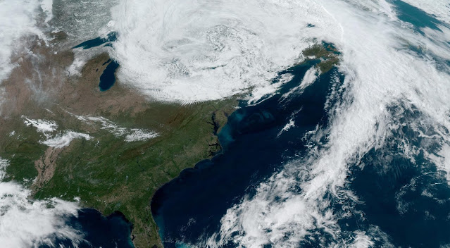
[Top satellite image via NOAA]


You can follow me on Facebook, Mastodon, Twitter, Instagram, or send me an email.

Please consider subscribing to my Patreon. Your support helps me write engaging, hype-free weather coverage—no fretting over ad revenue, no chasing viral clicks. Just the weather.


April 3, 2023

Another Round Of Significant Severe Weather Is Likely On Tuesday


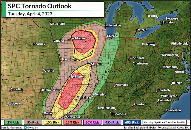
Tuesday's severe weather map across the central United States may look eerily familiar if you paid attention to the weather last Friday.

Many of the same areas pummeled by terrible storms a few days ago are at risk for more severe weather over the next 48 hours, with strong tornadoes possible again alongside the threat for damaging winds and large hail.

The Risk

The Storm Prediction Center issued a moderate risk for severe weather—a four out of five on the categorical scale measuring the risk for dangerous storms—across two separate areas.


The first covers eastern Iowa and northern Missouri, while the second blankets much of western Arkansas and a large chunk of southwestern Missouri. These include the cities of Fayetteville, Arkansas; Springfield, Missouri; and Cedar Rapids, Davenport, Iowa City, and Waterloo in Iowa.

Both of these moderate risks are driven by the threat for strong, long-lived tornadoes. The strongest storms here could produce hail the size of golf balls or larger along with damaging winds. 


There's also an enhanced risk for severe weather—a solid three on the five-category scale—stretching from Tyler, Texas, all the way north to Madison, Wisconsin. Areas in and around the enhanced risk could also see tornadoes, some strong and long-lived, as well as large hail and widespread damaging wind gusts.

Nighttime Storms Are A Serious Hazard

It looks like things are going to kick off a little later in the day than they did on Friday, which will push a good chunk of Tuesday's severe weather risk later into the evening and nighttime hours. Severe weather is bad any time of the day, but it's especially hazardous at night.

Folks are at serious risk of missing urgent warnings as they wind down and go to bed. Wireless emergency alerts on smartphones have saved countless lives over the past decade after the screeching tone woke people up and gave them just enough time to dive for cover. It's best to have multiple ways to receive alerts in case one fails—get a weather radio!—but if nothing else, make sure your phone and all your friends' and family members' phones are ready to receive tornado warning alerts.

The other reason nighttime storms are extra dangerous is that it's nearly impossible to see tornadoes at night until they're right on top of you. Like it or not, it's human nature and a cultural idiosyncrasy that we want to see a tornado before taking shelter. That's dangerous during the day, but a straight-up gamble with your life at night.

The Setup

It's worth saying up front that no two severe weather events are ever exactly alike. Not everyone under the highest risks here will see severe weather. There are always "modes of failure," as meteorologists like to put it, that can preclude widespread severe weather.

That being said, the potential certainly exists for Tuesday's storms to produce strong, long-lived tornadoes, as well as widespread damaging wind gusts and hail the size of golf balls or larger.

Another low-pressure system moving out of Colorado will scoot across the Plains toward the Upper Midwest during the day Tuesday. This strengthening storm could moonlight as a model for a textbook illustration of a classic early-spring troublemaker.

Source: TwisterData.com

Cold air to the north, warm air to the south, and an abundance of tropical moisture will allow the system to generate a ripping blizzard over the northern Plains while fueling a significant severe weather risk from Wisconsin to Texas. 

The above model shows Theta-E, which is a good illustrator of instability as it combines temperatures and dew points all in one graphic.

Higher values show a warmer, soupier air, while cooler colors show drier and more stable conditions. This does a really good job showing the center of the low and its associated cold and warm fronts, laying out the general setup that'll fuel Tuesday's severe weather threat. You can also see the stout southerly winds feeding the wind shear that boosts the storms.

Strong supercells are likely near the triple-point, or the area where the cold and warm fronts meet near the center of the low. This accounts for the heightened tornado and large hail risk across eastern Iowa and northern Missouri.

Farther south, another bullseye for the tornado/hail risk exists over western Arkansas and southwestern Missouri as supercell thunderstorms develop amid strong wind shear blowing over the region.

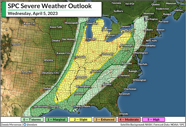
The Severe Risk Continues Wednesday

This low-pressure system will track northeast across the Great Lakes into northern Ontario through Wednesday, which means that the cold front is in no hurry to race to the Atlantic coast. 


We'll see a renewed round of severe thunderstorms from the Mississippi to the Appalachians during the day Wednesday.

An expansive threat for damaging winds will develop in any lines of thunderstorms that bubble along the cold front on Wednesday, with the risk for isolated tornadoes popping up from time to time.

The SPC mentioned in their forecast on Monday that supercells are possible around the eastern Great Lakes, which could enhance the tornado threat in this region.

Snow And Ice

Severe weather is far and away going to be the biggest threat from this storm, but don't sleep on the risk for serious snow and ice on the cold side of the low.

Source: NWS

Folks across the northern Plains are on alert for blizzard conditions and the potential for two to three feet of snow. The latest forecast from the National Weather Service shows a swath of 12-18+ inches of snow covering a huge area from central Wyoming straight into northwestern Ontario.

This heavy, wet snow will be accompanied by powerful wind gusts that will lead to prolonged blizzard conditions at times. Travel will be impossible for a time during the storm.

Source: NWS

A lengthy period of freezing rain is likely in the murky area between the heavy snow and the strong storms. Plenty of folks across the Upper Midwest could see one-quarter of an inch of ice accretion through Wednesday, which is enough to cause tree damage and power outages.

Even greater ice accretions are likely across interior Maine on Wednesday night, which is certain to lead to tree damage and power outages.


You can follow me on Facebook, Mastodon, Twitter, Instagram, or send me an email.

Please consider subscribing to my Patreon. Your support helps me write engaging, hype-free weather coverage—no fretting over ad revenue, no chasing viral clicks. Just the weather.