Another Round Of Significant Severe Weather Is Likely On Tuesday
Tuesday’s severe weather map across the central United States may look eerily familiar if you paid attention to the weather last Friday.
Many of the same areas pummeled by terrible storms a few days ago are at risk for more severe weather over the next 48 hours, with strong tornadoes possible again alongside the threat for damaging winds and large hail.
The Risk
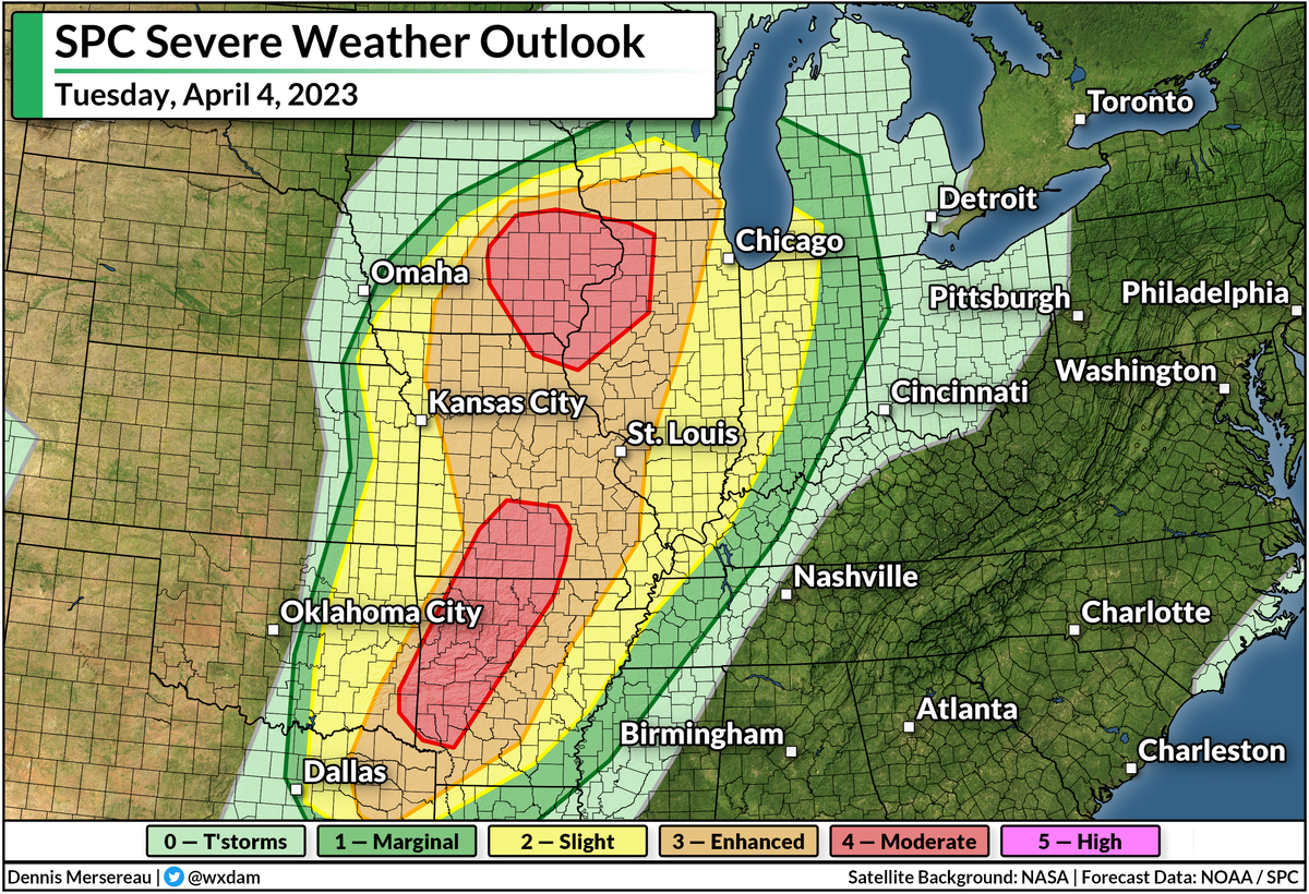
The Storm Prediction Center issued a moderate risk for severe weather—a four out of five on the categorical scale measuring the risk for dangerous storms—across two separate areas.

The first covers eastern Iowa and northern Missouri, while the second blankets much of western Arkansas and a large chunk of southwestern Missouri. These include the cities of Fayetteville, Arkansas; Springfield, Missouri; and Cedar Rapids, Davenport, Iowa City, and Waterloo in Iowa.
Both of these moderate risks are driven by the threat for strong, long-lived tornadoes. The strongest storms here could produce hail the size of golf balls or larger along with damaging winds.
There’s also an enhanced risk for severe weather—a solid three on the five-category scale—stretching from Tyler, Texas, all the way north to Madison, Wisconsin. Areas in and around the enhanced risk could also see tornadoes, some strong and long-lived, as well as large hail and widespread damaging wind gusts.
Nighttime Storms Are A Serious Hazard
It looks like things are going to kick off a little later in the day than they did on Friday, which will push a good chunk of Tuesday’s severe weather risk later into the evening and nighttime hours. Severe weather is bad any time of the day, but it’s especially hazardous at night.
Folks are at serious risk of missing urgent warnings as they wind down and go to bed. Wireless emergency alerts on smartphones have saved countless lives over the past decade after the screeching tone woke people up and gave them just enough time to dive for cover. It’s best to have multiple ways to receive alerts in case one fails—get a weather radio!—but if nothing else, make sure your phone and all your friends’ and family members’ phones are ready to receive tornado warning alerts.
The other reason nighttime storms are extra dangerous is that it’s nearly impossible to see tornadoes at night until they’re right on top of you. Like it or not, it’s human nature and a cultural idiosyncrasy that we want to see a tornado before taking shelter. That’s dangerous during the day, but a straight-up gamble with your life at night.
The Setup
It’s worth saying up front that no two severe weather events are ever exactly alike. Not everyone under the highest risks here will see severe weather. There are always “modes of failure,” as meteorologists like to put it, that can preclude widespread severe weather.
That being said, the potential certainly exists for Tuesday’s storms to produce strong, long-lived tornadoes, as well as widespread damaging wind gusts and hail the size of golf balls or larger.
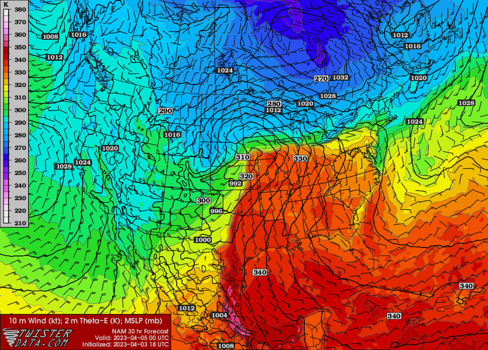
Another low-pressure system moving out of Colorado will scoot across the Plains toward the Upper Midwest during the day Tuesday. This strengthening storm could moonlight as a model for a textbook illustration of a classic early-spring troublemaker.
 |
| Source: TwisterData.com |
Cold air to the north, warm air to the south, and an abundance of tropical moisture will allow the system to generate a ripping blizzard over the northern Plains while fueling a significant severe weather risk from Wisconsin to Texas.
The above model shows Theta-E, which is a good illustrator of instability as it combines temperatures and dew points all in one graphic.
Higher values show a warmer, soupier air, while cooler colors show drier and more stable conditions. This does a really good job showing the center of the low and its associated cold and warm fronts, laying out the general setup that’ll fuel Tuesday’s severe weather threat. You can also see the stout southerly winds feeding the wind shear that boosts the storms.
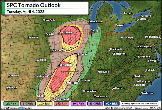
Strong supercells are likely near the triple-point, or the area where the cold and warm fronts meet near the center of the low. This accounts for the heightened tornado and large hail risk across eastern Iowa and northern Missouri.
Farther south, another bullseye for the tornado/hail risk exists over western Arkansas and southwestern Missouri as supercell thunderstorms develop amid strong wind shear blowing over the region.
The Severe Risk Continues Wednesday
This low-pressure system will track northeast across the Great Lakes into northern Ontario through Wednesday, which means that the cold front is in no hurry to race to the Atlantic coast.
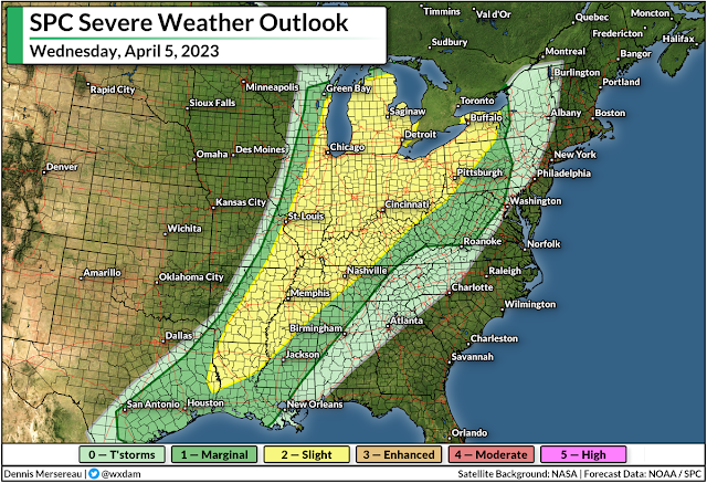
We’ll see a renewed round of severe thunderstorms from the Mississippi to the Appalachians during the day Wednesday.
An expansive threat for damaging winds will develop in any lines of thunderstorms that bubble along the cold front on Wednesday, with the risk for isolated tornadoes popping up from time to time.
The SPC mentioned in their forecast on Monday that supercells are possible around the eastern Great Lakes, which could enhance the tornado threat in this region.
Snow And Ice
Severe weather is far and away going to be the biggest threat from this storm, but don’t sleep on the risk for serious snow and ice on the cold side of the low.
 |
| Source: NWS |
Folks across the northern Plains are on alert for blizzard conditions and the potential for two to three feet of snow. The latest forecast from the National Weather Service shows a swath of 12-18+ inches of snow covering a huge area from central Wyoming straight into northwestern Ontario.
This heavy, wet snow will be accompanied by powerful wind gusts that will lead to prolonged blizzard conditions at times. Travel will be impossible for a time during the storm.
 |
| Source: NWS |
A lengthy period of freezing rain is likely in the murky area between the heavy snow and the strong storms. Plenty of folks across the Upper Midwest could see one-quarter of an inch of ice accretion through Wednesday, which is enough to cause tree damage and power outages.
Even greater ice accretions are likely across interior Maine on Wednesday night, which is certain to lead to tree damage and power outages.


