Southern California faces a serious flash flood threat with Hurricane Hilary
A serious flooding threat will likely develop across parts of California, Arizona, and Nevada beginning this weekend as Hurricane Hilary or its remnants track into the region through early next week.
Every once and a while, the meteorological factors align to make the improbable happen. A tropical system surviving long enough to approach southern California takes a multitude of ingredients falling together just right to come to fruition.
Regardless of its ‘official’ title by the time it reaches California, Hilary or its remnants could bring significant, widespread, and life-threatening flooding to California, Arizona, and Nevada by early next week. Folks who live in flood-prone areas need to pay close attention to watches and warnings in the coming days.
Hurricane Hilary rapidly strengthening near Mexico
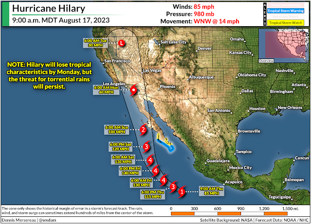
The National Hurricane Center expects Hilary to reach major hurricane status as it approaches the Baja Peninsula over the next couple of days. Forecasters call for the system to peak as a strong category four storm overnight Friday into Saturday morning before losing steam as it approaches cooler waters.
Hilary will begin picking up speed as it travels farther north, possibly making landfall on the Baja Peninsula on Sunday as it tracks toward southern California. The system—or its remnants—should cross the international border on Sunday night or Monday morning.
Even though Hilary will fall apart soon after landfall, the system’s prolific tropical moisture will fuel torrential rains as its remnants push north through California, Arizona, and Nevada through early next week.
Folks in the west don’t see these NHC maps very often unless they’re tracking weather back east. The forecast shows the predicted center of the storm at each time step over the next five days. The cone of uncertainty around the forecast points is the historical margin of error in the NHC’s forecasts. A storm’s center typically stays within that cone of uncertainty about two-thirds of the time.
Heavy rain and gusty winds usually extend hundreds of miles from the center of the storm, so when forecasters say “don’t focus on the exact track of the storm,” it’s a silly-seeming reminder that storms are much larger than a single point on a map.
What could happen across the Western U.S.
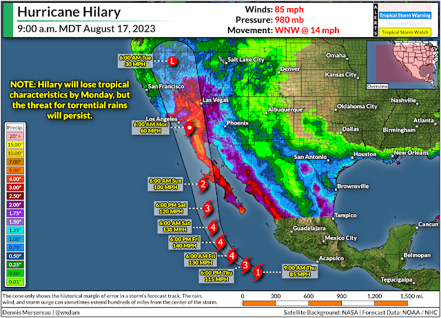
Far and away the greatest threat with this system will be torrential rainfall and widespread flash flooding. This outcome is likely whether or not Hilary reaches California as a tropical storm.
The vast plume of tropical moisture lofted into the atmosphere by a hurricane doesn’t just disappear when the storm starts to fizzle out. We’ll see this tropical moisture surge inland across California, Arizona, and Nevada this weekend and continue through Monday and Tuesday.
Such a rich reserve of tropical moisture aloft acts like a reservoir for thunderstorms to tap into, allowing them to produce copious rainfall totals in a short period of time.
This kind of a situation would cause problems in areas where they’re used to heavy rainfall. A setup like this across desert areas, urban development, mountains, and lingering burn scars will cause widespread flash flooding, landslides, and mudslides for the duration of the heavy rains.
We’re likely going to see significant flooding throughout the region regardless of Hilary’s status by the time it reaches the area. The greatest threat for flooding usually falls along the eastern side of a system’s track, which would expose the deserts and mountains to the potential for 5+ inches of rain in a relatively short period of time.
Stay alert for watches and warnings if you live in a flood-prone area. Keep multiple routes in mind if you have to drive through areas expecting heavy rainfall. Never try to drive across a flooded roadway. It takes very little water for a vehicle to lose traction and float downstream. It’s impossible to tell how deep the water is until it’s too late, and the road is sometimes washed out beneath the floodwaters.
Why we’re dealing with such an odd situation
Like a flipped quarter landing on its side, Hurricane Hilary seems to have everything working in its favor to bring significant impacts to California, Arizona, and Nevada by this weekend.
 |
| Source: NOAA |
California almost entirely avoids tropical systems because upwelling off the coast keeps the sea surface here far too chilly to sustain a tropical system. Only two systems in the past century have reached Californian soil as tropical systems—Jennifer-Katherine in 1963, and Nora in 1997—both as weakening tropical depressions.
Nora is an especially interesting case, as it was a powerful hurricane that formed during a strong El Niño year and moved along a somewhat similar path as Hilary is expected to follow. The system tracked into the desert southwest as a tropical depression and brought tremendous flooding to the region as it pushed inland.
Tropical systems are rare enough here to count on one hand because the frigid ocean waters rob these systems of virtually all their energy, forcing them to fall apart in spectacular fashion.
However, it seems Hurricane Hilary is on track to exploit as many favorable factors as possible. It’s going to run parallel to the Baja Peninsula, allowing the center of the storm to avoid cool water as much as possible.
 |
| Source: Tropical Tidbits |
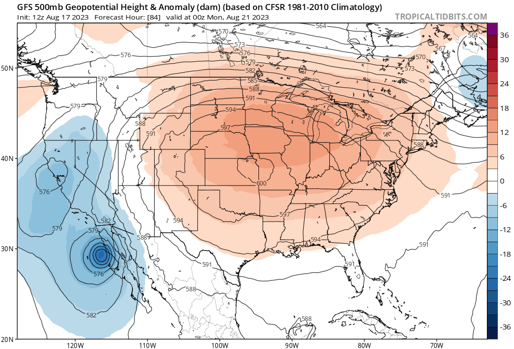
It’s also riding around the edge of a significant ridge of high pressure building over the middle of the United States. This is the ‘heat dome’ you’ve probably heard will roast much of the country east of the Rockies through next week.
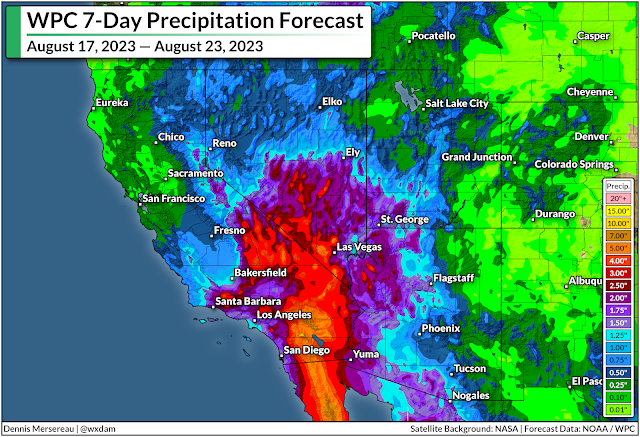
You don’t even need to look at that upper-level map to see the ridge’s influence…just look at the precipitation chart to see where it’s going to be hot and sunny, and where all the storms and disturbances will ride the rim of the ridge. (Say that five times fast.)
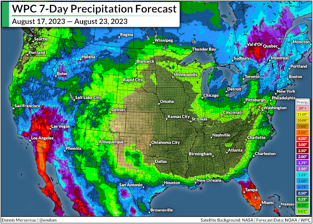
This forecast from the Weather Prediction Center also does a great job highlighting how Hilary’s remnant moisture will continue streaming over the northern Rockies and deep into Canada through next week.
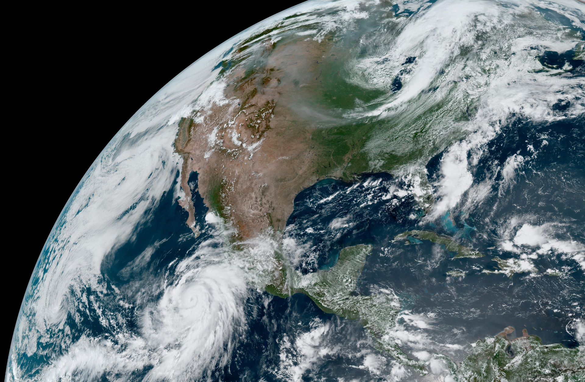
[Satellite Image: NOAA]


