Skip to content
DAMWeather DAMWeather DAMWeather

The weather can get scary. Reporting on it doesn't have to be.

DAMWeather DAMWeather DAMWeather

The weather can get scary. Reporting on it doesn't have to be.

  • About Me
  • All Bylines
    • Books, Bylines, and Press
    • The Skies Above (Book)
    • Extreme Weather (Book)
    • The Weather Network
    • The Vane
    • Forbes
    • Capital Weather Gang
    • Mental Floss
  • Maps
    • Hurricane Maps
    • Hurricane Names
    • Monthly Tornadoes
    • Tornado Tracks
    • F5/EF-5 Tornadoes
    • SPC High Risk Days
  • GIS Resources
  • Contact Me
    • Bluesky
    • Facebook
    • Instagram
  • wxdam.com

Tropical Storm Erin set to become Atlantic’s first hurricane of 2025

By Dennis Mersereau
August 11, 2025 3 Min Read

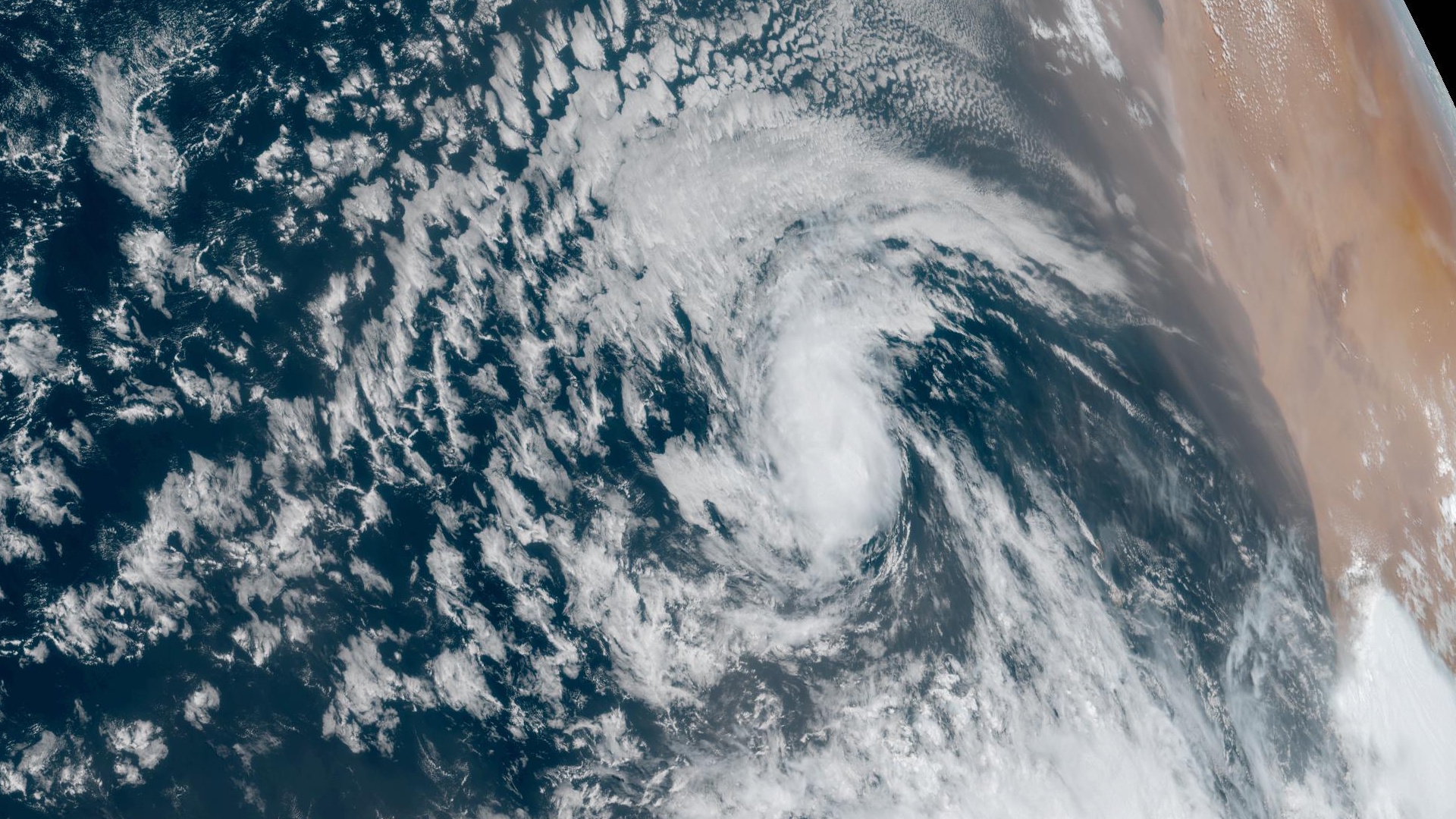
Tropical Storm Erin formed off the Cabo Verde Islands on Monday. The storm is set to become the first hurricane—and possibly the first major hurricane—of the 2025 Atlantic season later this week.
A vigorous tropical wave rolling off the coast of Africa got its act together in a hurry as it emerged over the warm waters of the eastern Atlantic Ocean, quickly organizing into the season’s fifth named storm. 

Like all storms that originate in the Cabo Verde region, this is going to be an 8-10+ day marathon watching this storm march west across the Atlantic basin. 
Environmental conditions are favorable for steady intensification in the days to come.

The National Hurricane Center expects Erin to gradually strengthen over the next five days, with the agency’s forecast explicitly calling for a major hurricane in the central Atlantic by Wednesday.
These long-duration storms cause quite the anxiety spike among coastal residents who are constantly refreshing weather pages in hopes of learning more about the system’s next move.
Unfortunately, it’s far too soon to say exactly where the storm will track beyond next weekend. We can look at signals in the models to get an idea of where it may track beyond the end of the NHC’s five-day forecast. 
Most tropical storms and hurricanes in the Atlantic are steered along by large ridges of high pressure parked over the center of the ocean. The strength and placement of these highs dictate how far west they travel before they begin to recurve. (Some storms don’t recurve at all.)
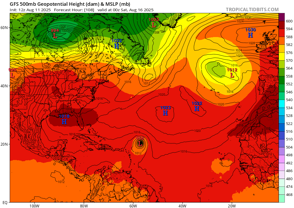
A model image showing ridges and troughs in the upper atmosphere on Friday evening. SOURCE: Tropical Tidbits

A stronger high-pressure system will allow the system to move farther west, posing a greater threat to the U.S. and Atlantic Canada. A weaker high provides more opportunities for the storm to recurve north and out to sea. 
Right now, signals in the models show decent odds that a weaker high will probably allow Erin to recurve and track near Bermuda before turning out to sea. However, there’s plenty of time for things to change. Very small changes in the near-term can have big long-term effects in a storm’s track.
We’re coming up on the peak of hurricane season. Tropical Storm Erin’s impending marathon is a good reminder that folks who live in coastal states and provinces should be ready for storms well before a threat is on the horizon.  
[Satellite image courtesy of NOAA.]


Follow me on Facebook | Bluesky | Instagram

Get in touch! Send me an email.

Please consider subscribing to my Patreon. Your support helps me write engaging, hype-free weather coverage—no fretting over ad revenue, no chasing viral clicks. Just the weather.


Author

Dennis Mersereau

I have 15+ of experience providing hype-free weather information for folks across the United States and around the world. In addition to DAMWeather, I also contribute to The Weather Network as a digital writer and weather specialist.

Follow Me
Other Articles
Previous

Tropical Storm Dexter limps out to sea as more systems try to form

Next

Hurricane Erin’s dangerous waves, rip currents likely to hit U.S. East Coast


Local ◈ UTC
Facebook | Bluesky
Instagram | Threads | Email
DAMWeather is now ad-free! Everyone benefits from engaging, hype-free weather coverage. Please consider supporting my efforts through Patreon:


Order The Skies Above today!

Bookshop.org || Barnes & Noble
Mountaineers Books || Amazon

My latest book, The Skies Above, is now available!

Did you know a puffy cloud can weigh millions of pounds? Or that every rainbow you see is unique to you?

Our atmosphere is full of spectacular sights that are always within your reach. Glistening layers of fog, gorgeous sunsets, and brilliant meteors flashing through the sky can light up even the calmest day.

The Skies Above, published by Mountaineers Books, is a celebration of what we overlook when we look up. I was thrilled to work with the editors and illustrators at Indelible Editions to share with you the quotidian beauty of our sky.

Order your copy now and learn about the wonders we take for granted every day.

I teamed up with the editors of Outdoor Life magazine to write The Extreme Weather Survival Manual, your guide to surviving and thriving in almost any weather condition. Whether you're an avid outdoorsperson or you enjoy watching the radar from the comfort of your home, you're sure to find helpful tips, advice, and new bits of knowledge in this fascinating book.

You can buy my book today through Amazon.
An error has occurred, which probably means the feed is down. Try again later.
  • 2026 (31)
  • 2025 (49)
  • 2024 (59)
  • 2023 (43)
  • 2022 (57)
  • 2021 (71)
  • 2020 (83)
  • 2019 (88)
  • 2018 (92)
  • 2017 (1)
  • 2016 (4)
  • 2015 (10)

Copyright 2026 — DAMWeather. All rights reserved. Blogsy WordPress Theme