Skip to content
DAMWeather DAMWeather DAMWeather

The weather can get scary. Reporting on it doesn't have to be.

DAMWeather DAMWeather DAMWeather

The weather can get scary. Reporting on it doesn't have to be.

  • About Me
  • All Bylines
    • Books, Bylines, and Press
    • The Skies Above (Book)
    • Extreme Weather (Book)
    • The Weather Network
    • The Vane
    • Forbes
    • Capital Weather Gang
    • Mental Floss
  • Maps
    • Hurricane Maps
    • Hurricane Names
    • Monthly Tornadoes
    • Tornado Tracks
    • F5/EF-5 Tornadoes
    • SPC High Risk Days
  • GIS Resources
  • Contact Me
    • Bluesky
    • Facebook
    • Instagram
  • wxdam.com

Heavy snow possible with significant weekend East Coast storm

By Dennis Mersereau
January 27, 2026 3 Min Read

The frigid pattern locked over the eastern United States may have one more trick up its sleeve this weekend in the form of a major coastal storm.
A potent upper-level low will swing south out of Canada late this week, bringing a renewed round of bitterly cold temperatures to the eastern half of the U.S. 
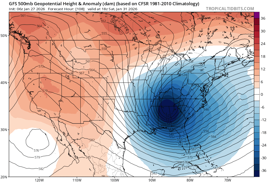
A model image showing the potent trough in the upper atmosphere on Saturday afternoon. (Tropical Tidbits)
This trough will likely spawn a coastal low-pressure system around the Carolinas late Friday or early Saturday, which would then parallel the coast through the weekend as it moves toward the Canadian Maritimes. 
A strengthening coastal storm with a bountiful reserve of cold air is a recipe for a potentially disruptive winter storm for many communities up and down the eastern seaboard.

The above graphic shows the Weather Prediction Center’s probability of at least moderate winter weather impacts between 9:00 a.m. Saturday and 9:00 a.m. Sunday. The exact areas affected will obviously change as we get closer to the event, but this is a good proxy for where forecasters currently believe there’s a potential for heavy snowfall this weekend. 
The key to impacts from any coastal storm is track, track, track. The precise track of the eventual low-pressure system will determine who sees snow and how much falls.
A track too close to the coast and you’ll get a messy mix with snow inland. One that stays too far offshore and the heaviest precipitation will stay over open waters. The details will grow clearer later this week as the event draws closer. 
As always, keep an eye on the forecast and scout out a trusted local meteorologist (not a weather app, please) to guide you through the lead-up to this potentially impactful winter storm.

Either way, it’s going to remain unseasonably cold into this weekend and possibly (likely?) into the first week of February.
Between the center of high pressure over the central U.S. and the winds blowing around our developing coastal storm, chilly temperatures will break through and make it all the way to southern Florida by Sunday morning. A forecast low of 26°F in Orlando would be the coldest temperature there since December 2010.


Follow me on Facebook | Bluesky | Instagram

Get in touch! Send me an email.

Please consider subscribing to my Patreon. Your support helps me write engaging, hype-free weather coverage—no fretting over ad revenue, no chasing viral clicks. Just the weather.


Author

Dennis Mersereau

I have 15+ of experience providing hype-free weather information for folks across the United States and around the world. In addition to DAMWeather, I also contribute to The Weather Network as a digital writer and weather specialist.

Follow Me
Other Articles
Previous

800,000+ power outages continue amid dangerously cold temperatures

Next

Heavy snow possible with significant weekend East Coast storm


Local ◈ UTC
Facebook | Bluesky
Instagram | Threads | Email
DAMWeather is now ad-free! Everyone benefits from engaging, hype-free weather coverage. Please consider supporting my efforts through Patreon:


Order The Skies Above today!

Bookshop.org || Barnes & Noble
Mountaineers Books || Amazon

My latest book, The Skies Above, is now available!

Did you know a puffy cloud can weigh millions of pounds? Or that every rainbow you see is unique to you?

Our atmosphere is full of spectacular sights that are always within your reach. Glistening layers of fog, gorgeous sunsets, and brilliant meteors flashing through the sky can light up even the calmest day.

The Skies Above, published by Mountaineers Books, is a celebration of what we overlook when we look up. I was thrilled to work with the editors and illustrators at Indelible Editions to share with you the quotidian beauty of our sky.

Order your copy now and learn about the wonders we take for granted every day.

I teamed up with the editors of Outdoor Life magazine to write The Extreme Weather Survival Manual, your guide to surviving and thriving in almost any weather condition. Whether you're an avid outdoorsperson or you enjoy watching the radar from the comfort of your home, you're sure to find helpful tips, advice, and new bits of knowledge in this fascinating book.

You can buy my book today through Amazon.
An error has occurred, which probably means the feed is down. Try again later.
  • 2026 (31)
  • 2025 (49)
  • 2024 (59)
  • 2023 (43)
  • 2022 (57)
  • 2021 (71)
  • 2020 (83)
  • 2019 (88)
  • 2018 (92)
  • 2017 (1)
  • 2016 (4)
  • 2015 (10)

Copyright 2026 — DAMWeather. All rights reserved. Blogsy WordPress Theme