December 31, 2021

Widespread Severe Weather Possible Across The Southeast On New Year's Day


A robust low-pressure system developing over the center of the United States on Friday will push east through New Year's Day, bringing a widespread risk for severe thunderstorms to the southeastern states. As always, a midwinter risk for severe weather is especially risky because the sun sets early and folks aren't tuned in  to the threat for bad storms this time of year.

The low, developing over the southern Plains on Friday afternoon, will start to push into the Midwest overnight Friday into Saturday. If you live just about anywhere in the southern United States, you know that it's been unusually warm and humid for a while now. Southerly flow pulled north by the low will accentuate that spring-like warmth, providing the instability and lift needed to trigger thunderstorms.


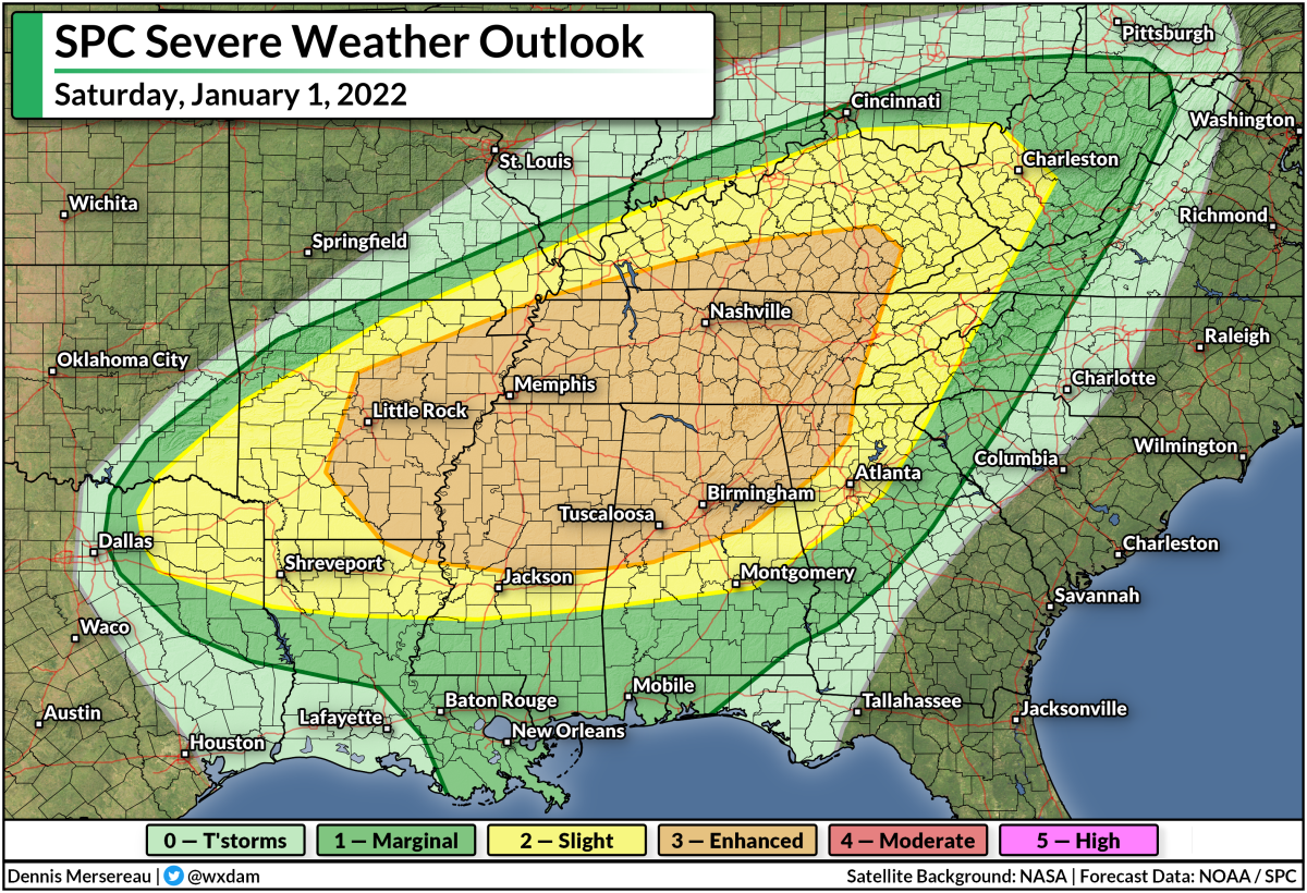
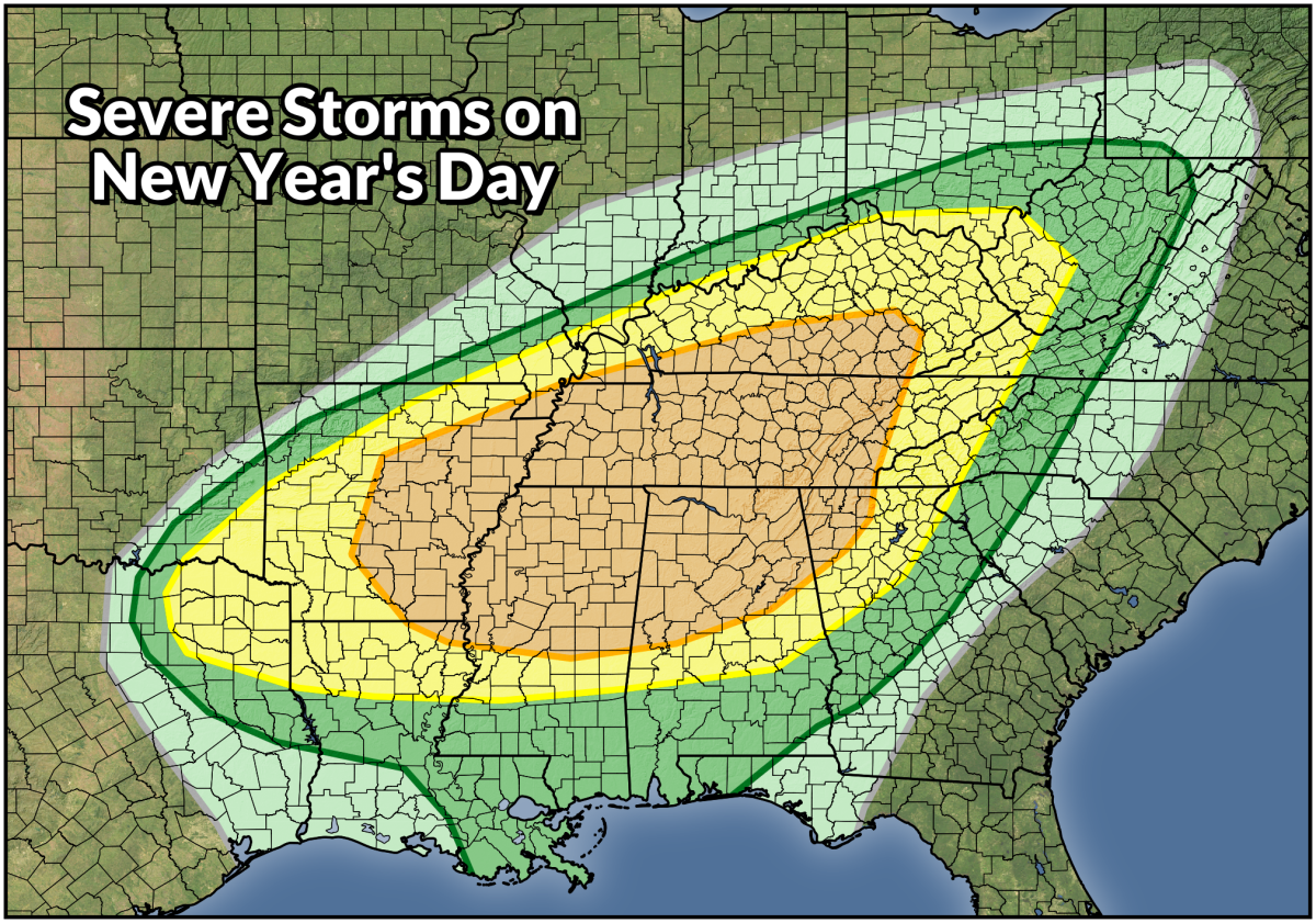
The latest forecast from the Storm Prediction Center (SPC) paints a widespread risk for severe thunderstorms on Saturday that spans south as far west as Dallas, as far south as New Orleans, and as far north as the Mason-Dixon line in the Appalachians. The greatest threat for dangerous thunderstorms lies within the enhanced risk (orange) area, which covers Little Rock, Memphis, Nashville, Tuscaloosa, Huntsville, and Birmingham.


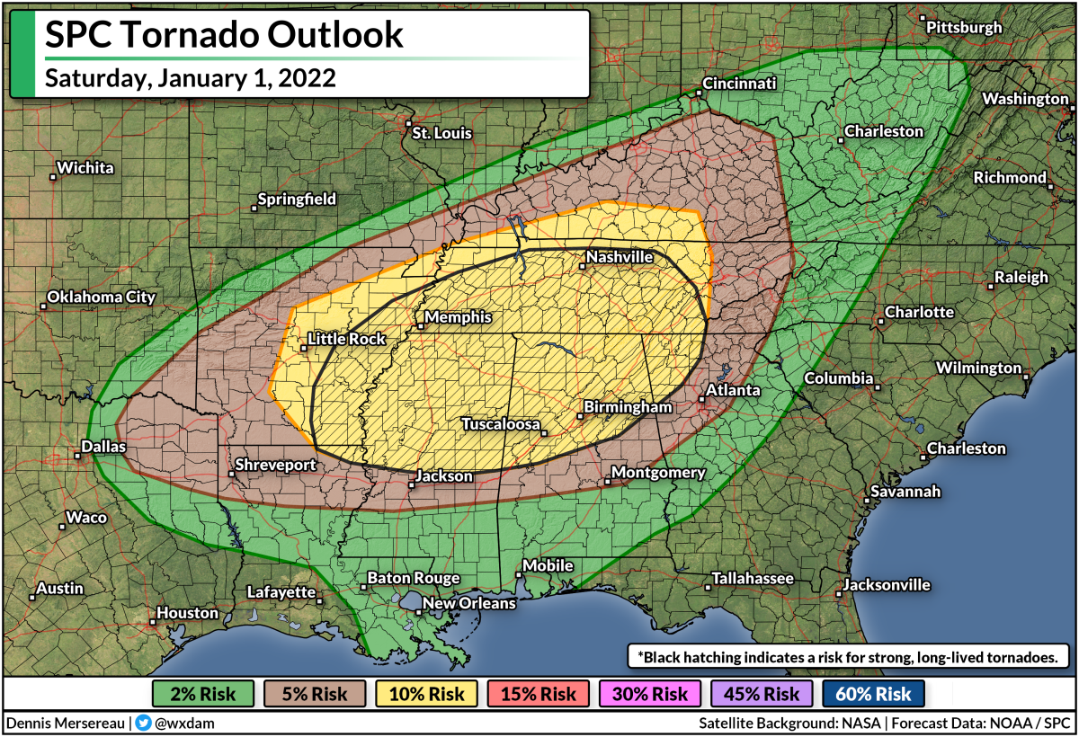
Forecasters issued the enhanced risk for an elevated threat for tornadoes from any thunderstorms that form in the region.

There is some uncertainty around the tornado risk on Saturday. The SPC's forecast discussion on Friday notes that the environment will be very favorable for supercells to develop, but limited instability may inhibit the development of thunderstorms in the area. Later in the evening, a squall line following the cold front will bring another chance for spin-up tornadoes along the leading edge of the line.


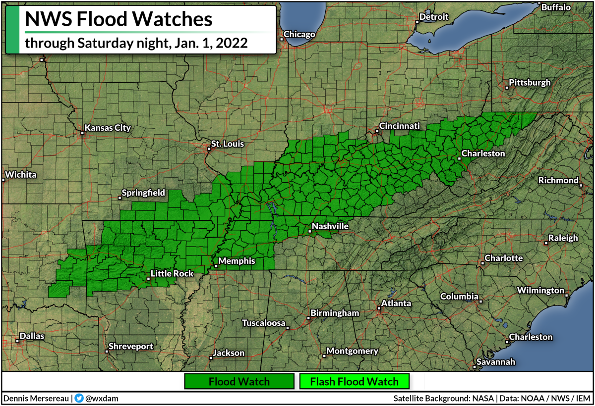
There's also a risk for flash flooding this weekend, mostly across the Ohio River Valley. Steady rain and thunderstorms will produce several inches of rain along and just south of the Ohio River. The rain will fall fast enough that it could lead to flooding.

Severe storms are bad, but flooding kills more people every year than winds and tornadoes. It's impossible to tell how deep the water is until it's too late, and it only takes a few inches of moving water to lift a vehicle and carry it downstream.

The risk for severe weather will follow the cold front as we head into Sunday, bringing a risk for damaging winds and possibly a few tornadoes to the rest of the southeast through the evening hours.

If you live in or anywhere near the risk for storms this weekend, please make sure you have a way to receive severe thunderstorm and tornado warnings the moment they're issued. Many of the storms on Saturday will occur after sunset. Nighttime severe weather is especially dangerous because you can't see what's coming your way (which is why you should always seek shelter if there's a warning!), and because people tune out and go to sleep. Make sure you have a way to receive severe weather warnings even if you're asleep.

Here's a bit I wrote on making sure you're prepared for severe storms from earlier in December after the horrible tornadoes in Kentucky:

Please get a weather radio and check your cell phone's emergency alert settings.

Smartphones are the most common way we receive tornado warnings these days. Modern technology geotargets warnings to your location, sending you a noisy push alert the moment your location is placed within a tornado warning polygon. Wireless emergency alerts have been credited with saving countless lives over the past decade. 

The only problem is that people tend to switch these alerts off after one or two ill-timed notifications, usually for routine tests or child abduction alerts. Please take a minute today to go into your smartphone's settings and ensure these alerts are activated for tornado warnings. It could very well wake you up and save your life when you're least expecting it.

What if your device's battery dies, you don't have good reception, or you simply can't hear your phone while you're asleep or in the other room? That's when a NOAA Weather Radio can come in handy.

NOAA Weather Radios are like smoke detectors for the weather. You can program these devices to sound a loud tone and automatically read a warning out loud when your county goes under a severe weather watch or warning. They can provide you ample warning when severe weather is on the way even if your electricity and internet go out.


You can follow me on Twitter or send me an email.

Please consider subscribing to my Patreon. Your support helps me write engaging, hype-free weather coverage—no fretting over ad revenue, no chasing viral clicks. Just the weather.
 

December 30, 2021

Thursday's Intense Wildfire Near Boulder, Colorado, Was Months In The Making


The intense wildfire that exploded near Boulder, Colorado, on Thursday afternoon was months in the making.

Social media pictures relayed a small sample of the nightmarish conditions residents, workers, and shoppers faced when fast-moving flames rapidly engulfed communities southeast of Boulder.


Flames forced residents to flee their homes in the towns of Superior and Louisville, both situated about six miles southeast of Boulder. As of 9:15 p.m. EST, news reports indicated that hundreds of homes and businesses were destroyed by the fire, including a shopping center and a hotel.

There's no word if anyone was injured or killed in the disaster, though sadly it wouldn't be a surprise if there were folks who couldn't evacuate before the fast-moving flames arrived.

This kind of firestorm is one of the most horrifying natural disasters possible, and the region has been inching toward this kind of eruption for a long time.


This week's update of the U.S. Drought Monitor found much of northeastern Colorado mired in an extreme drought. "Extreme" feels like an understatement. Denver International Airport has only seen 1.08" of rain since July 1st, making this the driest last-half of the year ever recorded.


Such a deep and prolonged drought desiccated vegetation, leaving woodlands and grasslands susceptible to the tiniest spark. Add in the fact that this has been one of the warmest Decembers on record in the region—Boulder's average high so far this month is 54.5°F, the fourth-warmest on record since the late 1800s—and you have the background ingredients for fires to spark and spread.

Then there was the wind. It was incredibly windy along the Front Range today. Downsloping winds screamed across the area on Thursday afternoon, with 80-100+ mph gusts recorded in and around Boulder for the bulk of the day. The combination of exceptional dryness, unusual warmth, and powerful winds allowed this fire to ignite without issue and spread with frightening speed.


The fire is so intense that the smoke plume is more than 100 miles long on radar.

Winds started to die down on Thursday evening, which should help crews get a handle on the flames and stop the inferno's progression into neighborhoods and business districts.

The kicker is that a winter storm warning is in effect for the affected areas. 


Beginning on Friday, the National Weather Service expects 6-8 inches of snow to fall across the Boulder area through Saturday afternoon, which should help to put out any hotspots that remain.

[Satellite: NOAA | Chart: xmACIS2]


You can follow me on Twitter or send me an email.

Please consider subscribing to my Patreon. Your support helps me write engaging, hype-free weather coverage—no fretting over ad revenue, no chasing viral clicks. Just the weather.
 

December 22, 2021

A Slug Of Moisture Heads For California And A Deep Chill Heads For Washington


It sure seems like the West Coast has gotten a decade's share of interesting weather over the past year. The active pattern will continue over the next couple of days as California and Oregon are socked with heavy rain and high-elevation snows. Meanwhile, a lobe of the polar vortex dipping into Western Canada will send bitterly cold air into the Pacific Northwest. Some spots could even see snow around Christmas.

Heavy Rain and Snow

Several surges of moisture will wash over the West Coast through the end of the week, bringing heavy rain to lower elevations and blockbuster snowfall to the mountain ranges. The National Weather Service says that 6-8 feet of snow is possible across California's mountains, with totals up to 10 feet possible in the highest peaks.


The precipitation forecast above (from the Weather Prediction Center) shows liquid precipitation totals from both rainfall and snowfall. That huge splotch of 10"+ of rain over the Sierra Nevada is entirely snow, showing how well the mountains will wring out every juicy drop of moisture heading their way.

Hefty rainfall totals are likely at lower elevations. All the major cities along the coast can expect several inches of rain over the next couple of days. This includes Los Angeles and San Diego, where rain is uncommon enough these days that a simple rain shower gets the breaking news treatment.

Watch out for the potential for flooding issues in vulnerable areas during heavy rainfall, especially areas that recently experienced wildfires. Burn scars make the ground impermeable, forcing rainwater to simply run off instead of absorbing into the ground.

A Cold Pattern Into 2022

Temperatures are set to dive across much of the Pacific Northwest heading into Christmas and likely lasting straight into the first week of January. Here's what the Climate Prediction Center's temperature outlook looks like for the next two weeks:


It's pretty rare to see that kind of confidence in below-normal temperatures in this part of the country!

It's about to get super cold on the Canadian Prairies. Temperatures will dive far below zero for the foreseeable future, with wind chill readings pushing -40°F at times by early next week. That surge of Arctic air isn't going to stop at the Rockies.

Frigid temperatures will spill down to sea level across the Pacific Northwest, where even Vancouver, B.C., is looking at the potential for significant snowfall heading into this weekend. Snow is possible even at lower elevations throughout western Washington, which is great news for Seattle-area snow lovers.

The National Weather Service in Seattle issued this graphic on Wednesday, highlighting their confidence in accumulating snow across lower elevations (including Seattle!) this weekend:


The real story here is the staying power of the cold air. It's going to get cold and stay cold for a long time. It's likely that Seattle will fall below freezing this weekend and not climb back above freezing for a week or longer. That's going to be rough on folks who don't have proper heating, proper warm clothes, or even adequate housing. Typical warming methods like public libraries, stores, and designated heating centers are going to be tricky with the latest coronavirus surge sweeping the country.

Remain mindful of the threat that extended exposure to cold weather can pose, and please check in on loved ones and neighbors you know or even suspect might not have adequate means of staying warm during this long winter chill.

[Model Graphic: Tropical Tidbits]


You can follow me on Twitter or send me an email.

Please consider subscribing to my Patreon. Your support helps me write engaging, hype-free weather coverage—no fretting over ad revenue, no chasing viral clicks. Just the weather.
 

December 15, 2021

Rare Mid-December Severe Weather Outbreak Targets Midwest On Wednesday Evening


Today is likely going to go down as one of those memorable days in weather history across the central United States as an intense low-pressure system sweeps from Colorado to northern Ontario. Downsloping winds behind the system have already gusted to 100+ mph in Colorado's Front Range, and damaging winds will spread into the Upper Midwest through the evening hours.

Just as serious, however, is the threat for severe weather that will target the Midwest late Wednesday afternoon into Wednesday night.


The Storm Prediction Center issued a moderate risk for severe weather, a four out of five on the scale measuring the threat for severe storms, which is unprecedented in this part of the country for this late in the year.

This event is unsettling not only for the severe weather potential itself, but because it's unfolding across an area not accustomed to this magnitude of threat just a week-and-a-half before Christmas.

A warm and unstable airmass is in place across the Midwest. Des Moines, Iowa, broke its all-time December temperature record this morning with a reading of 71°F, and the temperature will likely climb higher before the storms arrive.

The storms are going to fire up and move very quickly. You can already see the beginnings of the squall line in central Kansas on the satellite image above, snagged around 1:15 p.m. CST.

Thunderstorms will develop along and ahead of the cold front sweeping along the southern half of the low. This squall line will have no trouble mixing intense winds down to the surface, potentially leading to widespread reports of 70+ mph wind gusts as it passes through.


There's enough wind shear present that discrete thunderstorms, as well as the squall line itself, will likely produce at least a couple of tornadoes, especially across parts of Iowa and Minnesota. A few tornadoes could be strong or long-lived, which is a terrifying prospect because much of the activity will unfold after sunset.


Make sure you have a way to receive warnings the moment they're issued. Check your smartphone and ensure that wireless emergency alerts are activated for tornado warnings. Those alerts are proven life-savers and they're programmed to alert you the moment your location goes under a tornado warning.

Try to stay awake tonight if you're under the threat for severe weather. Don't go to bed until you're in the all-clear. If you have no choice but to go to bed before the storm threat is over (or if you just happen to doze off or not pay attention), make sure you've got a way to receive warnings when they're issued. Keep your phone by your bed. Check your weather radio and ensure that it's working. Keep a local news channel on high volume. Task a friend or relative with calling you if a warning is issued. Just make sure you've got a way to get to safety in a hurry if necessary.

Also, if you have tall trees or large tree limbs hanging near or over your home, consider avoiding those rooms during the gusty winds or severe thunderstorms. Trees falling into homes are the leading cause of wind-related injuries in a setup like this. 

Stay safe.

[Satellite: NOAA]


You can follow me on Twitter or send me an email.

Please consider subscribing to my Patreon. Your support helps me write engaging, hype-free weather coverage—no fretting over ad revenue, no chasing viral clicks. Just the weather.
 

December 14, 2021

A Quick-Hitting Storm Will Pack A Wallop With Destructive Winds, Severe Storms


A quick-hitting Colorado low will sweep over the central United States through Thursday and make a mess of things in its wake. The system will have it all: rain, snow, high winds, an extreme fire danger, and a risk for severe thunderstorms over parts of Iowa and Minnesota. 

Blink and you'll miss it. This storm is going to haul tail toward Canada, forming over Colorado on Wednesday morning and zoom into northern Ontario by the same time on Thursday morning. It's going to be quite the active 24 hours for a vast swath of the central United States, beginning with the threat for high winds and an extreme fire danger on the Plains.

Powerful Winds Likely on Wednesday


A dangerous situation is setting up along the path of the low from the Front Range straight through to the Great Lakes. Intense winds will easily mix down to the surface, bringing the threat for 60+ mph gusts that will topple trees, cause power outages, and toss around loose objects like Christmas decorations, patio furniture, trash cans, and grills.

The strongest winds will rake over the Front Range, where wind gusts could reach 100 mph in spots during the day on Wednesday. This is the graphic that NWS Denver made for the event, highlighting how dangerous conditions will be on Wednesday:


If the forecasts hold up, this will be a significant and memorable wind event for many folks in Colorado.

Strong winds will follow the path of the low as it races toward Canada. High wind watches and warnings are in place across the central Plains, a huge swath of the Midwest, and much of the Great Lakes in anticipation of damaging winds.

The criteria for wind advisories and high wind warnings varies from place to place, but it's safe to say that all of these regions will experience dangerous winds for a time on Wednesday and Thursday.

If you live in an area expecting powerful winds, remain mindful of tall trees or large tree limbs that loom over your home. Most wind-related injuries occur when trees or tree limbs fall into houses. If you have a big limb hanging over your bedroom, for example, consider avoiding that room as much as possible during the strong winds.

Prepare tonight for power outages tomorrow. Make sure your devices are charged and you have juiced-up flashlights within easy reach. (It's tough to feel around for flashlights batteries in the dark. Don't ask me how I know.)

High Fire Danger Accompanies The Winds

Powerful winds, warm temperatures, dry air, and ongoing drought conditions will all work together to create a high fire danger from the northern Texas Panhandle through central Kansas on Wednesday.


A high fire danger extends out to include communities from northeastern New Mexico to southern Nebraska. There aren't too many people who live in the affected areas, and I doubt many of you live there (thanks for reading if you do!), but it's the kind of day where any fire could quickly spiral out of control. One fire threatening one home is too many.

Severe Storms

The surge of moisture and warmer, unstable air on the south side of the low will set the stage for thunderstorms to develop over Iowa and Minnesota on Wednesday.


The Storm Prediction Center issued a slight risk for severe weather across much of Iowa and southern Minnesota. The strongest storms that form in and around this area could produce tornadoes, damaging winds, and large hail. It won't take much of a downdraft to pull those intense winds down to the surface.

As always, make sure that you have a way to receive severe weather warnings the moment they're issued. Take a moment to look at your phone and ensure that emergency alerts for tornado warnings are active, and that you have a way to hear warnings if you're asleep when rough weather moves through.

It's also worth noting that much of the area under that severe weather risk on Wednesday currently has several inches of snow on the ground. It's not out of the realm of possibility that we could get a picture or two of a tornado traversing a snow-covered landscape. (It's not unprecedented!)


You can follow me on Twitter or send me an email.

Please consider subscribing to my Patreon. Your support helps me write engaging, hype-free weather coverage—no fretting over ad revenue, no chasing viral clicks. Just the weather.
 

December 11, 2021

After A Historic December Tornado Outbreak, Please Get A Weather Radio


A significant and likely historic tornado outbreak unfolded across portions of the central United States late Friday night, with multiple intense, long-track tornadoes touching down across the Mississippi and Ohio River valleys. One of the tornadoes was particularly devastating, killing dozens of people and cutting a path that might have measured more than 200 miles long.

This was a well-predicted and well-warned event.

Forecasters highlighted the potential for significant severe thunderstorms across the hardest-hit areas several days in advance. The Storm Prediction Center issued an enhanced risk for severe weather a day in advance, and upgraded to a moderate risk—a four out of five on the scale measuring the risk for severe weather—the morning before the tornadoes.
Most of the communities hit by the tornadoes had long lead times. Tornadic debris signatures were clear as day on radar for the most significant tornadoes, allowing forecasters to issue tornado warnings and tornado emergencies well in advance of the storms' arrival.

Despite the forecasts and the warnings, we still experienced an unthinkable human toll during Friday night's storms. The latest reports indicate that more than 100 people may have died in the tornadoes, which would make this the deadliest tornado event since late May 2011, which included the devastating tornado that struck Joplin, Missouri.

Last night's tornado outbreak included three nightmare scenarios wrapped into one. We dealt with:

1) strong tornadoes hitting populated areas;
2) strong tornadoes touching down at night when people are asleep;
3) strong tornadoes during the "off-season," just two weeks before Christmas.

Any one of those situations is heart-stopping by itself. But it's a recipe for disaster when you combine all three into one horrific night.

Steep tornado-related casualties were common in the days before Doppler weather radar and large-scale warning systems. A tragedy like last night's tornado outbreak is so viscerally jarring today specifically because that kind of early-day casualty rate is so rare now.

The best warnings and the best forecasts weren't able to save dozens of lives last night. There are lots of reasons why it happened. Meteorologists and social scientists will have to study this event long and hard to figure out what went wrong and what they can do better in the future to help stave off another mass-casualty event like this.

But there's one thing you can do right now that mitigates your risk of getting hurt or worse if you find yourself under the threat of tornadoes any day or any time of the year: please get a weather radio and check your cell phone's emergency alert settings.

Smartphones are the most common way we receive tornado warnings these days. Modern technology geotargets warnings to your location, sending you a noisy push alert the moment your location is placed within a tornado warning polygon. Wireless emergency alerts have been credited with saving countless lives over the past decade. 

The only problem is that people tend to switch these alerts off after one or two ill-timed notifications, usually for routine tests or child abduction alerts. Please take a minute today to go into your smartphone's settings and ensure these alerts are activated for tornado warnings. It could very well wake you up and save your life when you're least expecting it.

What if your device's battery dies, you don't have good reception, or you simply can't hear your phone while you're asleep or in the other room? That's when a NOAA Weather Radio can come in handy.

NOAA Weather Radios are like smoke detectors for the weather. You can program these devices to sound a loud tone and automatically read a warning out loud when your county goes under a severe weather watch or warning. They can provide you ample warning when severe weather is on the way even if your electricity and internet go out.

We live in the smart home era. You can switch on your coffee pot using your voice while you're sitting on the toilet. Something like a weather radio may seem like outdated technology. But...who cares? They work! They work.

It's best to have multiple layers of protection when it comes to something as serious as severe weather. Weather radios are a great tool to have in your home just in case you miss a warning on your cell phone and you're not aware of threatening weather heading in your direction.

Last night's storms were a horrific tragedy. It's going to take a long time to figure out what went wrong and how forecasters and communicators can improve their products and their reach in the future to prevent more tragedies like this one. Take the opportunity today to ensure that you and your family are protected from severe weather no matter what time or what day it strikes.


You can follow me on Twitter or send me an email.

Please consider subscribing to my Patreon. Your support helps me write engaging, hype-free weather coverage—no fretting over ad revenue, no chasing viral clicks. Just the weather.
 

December 5, 2021

Freakishly Warm Temperatures Bathe Much Of U.S. To Begin Sept...uh, December


It's been a freakishly warm start to December across much of the United States as above-seasonal temperatures wash across the country. Temperatures climbed into the 70s and 80s pretty far north for this time of year, the type of temperature anomaly that's both pleasant and unsettling this late in the year. While we're not likely to see such high highs in the coming weeks, it's going to stay pretty warm heading toward Christmas.

Warmth

It's been warm lately. 77°F in Oklahoma City. 81°F in Dallas. 78°F in Charlotte. 77°F in Atlanta. These recent highs are more reminiscent of September than December, and it's all thanks to a beefy upper-level ridge that's parked over much of the United States.

The same pattern that's brought us unusually dry and warm weather east of the Rockies has allowed one storm after another to slam into the Pacific Northwest and Western Canada, triggering all sorts of chaos in British Columbia over the past couple of weeks.


The pattern is in the process of breaking...briefly, at least.

A short-lived blast of Arctic air sweeping down from Canada will be our last shot of "real" winter air for a while, it seems. Temperatures will dive below zero up near the border on Monday morning. Meanwhile, it's nice enough to sleep with the windows open for about half of the country.

Colder air will continue to filter south over the next couple of days before promptly exiting and returning us to above-seasonal temperatures.

La NiƱa

This kind of a pattern is a hallmark of La NiƱa winters. A La NiƱa occurs when the waters of the eastern equatorial Pacific Ocean grow colder than normal for several months at a time. This abnormally cool water can have a huge impact on the atmosphere above, which causes a ripple effect that affects weather patterns over Australia, Asia, and the Americas.

A typical winter would see the polar jet stream snaking around northern and central Canada while a subtropical jet stream moseys across the southern United States. Troughs and ridges in each jet stream bring us the active weather we come to expect during the cold season.

When we're in a La NiƱa pattern, though, both the subtropical and the polar jet streams dip south, taking the subtropical jet stream too far south to meaningfully affect U.S. weather. Meanwhile, the polar jet stream amplifies, allowing bigger troughs and ridges to sweep across North America. The end result is a warmer-than-normal pattern across much of the United States, with frosty temperatures across the Pacific Northwest and much of Western Canada.

If you've worn shorts in the last couple of days, congratulations: you've experienced this first-hand.

Above-Normal Heading Into Christmas


While our shorts-weather days are limited (unless you're one of those guys who wears basketball shorts all year—admit it), it's going to stay unseasonably warm for the next couple of weeks. 

The Climate Prediction Center's latest 8-14 day forecast shows a solid chance for above-normal temperatures for the entire contiguous United States outside of the West Coast.

This map doesn't show the intensity of the abnormally warm weather, but rather that forecasters are very confident that upper-level ridging will persist east of the Rockies and bring us unusually comfortable weather even as we're supposed to dive into the heart of winter.

Look on the bright side: it's great news if you hate snow, I guess!

[Satellite Image: NOAA]


You can follow me on Twitter or send me an email.

Please consider subscribing to my Patreon. Your support helps me write engaging, hype-free weather coverage—no fretting over ad revenue, no chasing viral clicks. Just the weather.