September 30, 2022

Hurricane Ian Hitting The Carolinas With High Winds, Flooding Rains


Hurricane Ian made its third and final landfall near Georgetown, South Carolina, on Friday afternoon as an 85 mph category one hurricane. The system produced a top-three storm surge in Myrtle Beach, and 90+ mph winds in Charleston Harbor. Ian will steadily weaken as it pushes inland, but the high winds and flooding rains will push through the Carolinas into Saturday.

The hurricane hitting the Carolinas is a far cry from the hurricane that slammed into southwestern Florida on Wednesday afternoon. Ian made landfall on the verge of category five strength, with its destructive winds pushing a devastating storm surge into the coast. 

Even though this isn't a powerful storm anymore, Ian is still a large and formidable hurricane. The footprint of its tropical storm force winds stretches more than 400 miles from one end to the other.


There's a lot of energy moving into the southeastern United States today, and judging by the lackadaisical view folks who live around here are taking with this storm, the extent of the winds and power outages may come as a surprise.

Hurricane Ian will be one of those storms that doesn't immediately wind down once it hits land. Tropical storm warnings and wind advisories stretch all the way to the Appalachian Mountains in anticipation of 40-50+ mph winds through Saturday. Winds this strong will lead to tree damage and power outages throughout the region. 


Flash flooding from heavy rain will remain a concern into Saturday morning for much of the region. We could see an additional 3-5 inches of rain in many spots, especially across South Carolina and the bulk of central North Carolina.

The system will be a mere ghost of its former might by Saturday, but its remnants will still linger around the Mid-Atlantic through the early workweek, bringing occasional bouts of rain to the region. We should see ex-Ian finally clear out by Tuesday, where it could seed the development of a weak nor'easter that heads toward the Canadian Maritimes.

[Satellite Image: NOAA]


You can follow me on Twitter or send me an email.

Please consider subscribing to my Patreon. Your support helps me write engaging, hype-free weather coverage—no fretting over ad revenue, no chasing viral clicks. Just the weather.


September 28, 2022

'Catastrophic' Hurricane Ian Making Landfall In Southwestern Florida


Hurricane Ian was one sneeze away from category five intensity as it careened into southwestern Florida on Wednesday.

The storm's rapid intensification over the steamy waters of the southern Gulf of Mexico saw Ian grow into a high-end category four hurricane with maximum winds of 155 mph. Forecasters at the National Hurricane Center (NHC) expect the storm to more or less maintain this strength as it pushes into the southwestern Florida coast through the day on Wednesday.


This is going to be a catastrophic storm for the region on a level that could easily surpass the devastation wrought by Hurricane Charley back in 2004. Former NHC Director Dr. Rick Knabb tweeted Wednesday morning that the entire extent of Charley's hurricane-force winds could comfortably fit within Ian's eye with room to spare.

Ian is a much larger and stronger storm than Charley was, and its destructive reach will spread over a much larger portion of Florida over the next couple of days.

Storm Surge

A devastating double-digit storm surge will push into southern Florida near where the hurricane makes landfall tonight. This is particularly terrifying for Charlotte Harbor and the mouth of the Caloosahatchee River, putting communities like Cape Coral, Fort Myers, and Punta Gorda at risk of a 12+ foot storm surge.

SOURCE: NHC

A storm surge on this magnitude will push very far inland, compounding the destruction. Thousands upon thousands of homes could be completely flooded out by this storm surge. Anyone who chose to remain at home (or didn't have the means to evacuate) will be at grave danger when the surge rushes in as Ian makes landfall on Wednesday night.

Flooding Rains

Hurricane Ian's ferocious winds are only part of this storm's danger. This will be remembered as a water storm as much as it'll be remembered for its destructive winds.

Florida will endure widespread flooding over the next couple of days as this slow-moving hurricane drops one to two feet of rain across the middle of the state. This much rain will inundate natural and man-made drainage systems, leading to flooding even in areas that don't typically flood during torrential rainfall.


The combination of wind damage, coastal storm surge, and inland flooding will stress local resources to their limit. Widespread water rescues are likely in the hardest-hit areas, and emergency officials may not be able to assist people whose homes are flooding during the storm's high winds.

The risk for flooding isn't just limited to Florida. Widespread heavy rain will push into the interior southeast as Ian pushes inland through this weekend.

As I explained in Sunday's post, Ian is encountering a complex setup that will allow the storm to wring out drenching rains on the southeast. We'll see widespread rainfall totals of 3-6+ inches across the region, which will lead to a risk for flash flooding as far inland as the Appalachians in Virginia.

Winds/Tornadoes

Storm surge and freshwater flooding from prolific rainfall will cause significant and costly damage to the region, but we can't ignore the risk for wind damage. The eyewall is scraping some heavily populated areas. We're going to see widespread structural damage, tree blowdowns, and heavy damage to the power grid as this storm pushes ashore.


The wind threat doesn't stop at the coast. Hurricane warnings span the Florida Peninsula, with hurricane conditions expected all the way into the Orlando metro area as Ian pushes inland.

Forecasters expect Ian to reemerge in the Atlantic Ocean before making another landfall near the Georgia/South Carolina border.

This secondary landfall will bring tropical storm/near hurricane conditions to coastal sections of Georgia and South Carolina, where hurricane watches and tropical storm warnings are in effect. There's a chance Ian could regain hurricane strength before making landfall again on Friday.

Tornadoes are also a big concern for the Florida Peninsula and coastal Carolinas as Ian makes its way through the region over the next couple of days. 


You can follow me on Twitter or send me an email.

Please consider subscribing to my Patreon. Your support helps me write engaging, hype-free weather coverage—no fretting over ad revenue, no chasing viral clicks. Just the weather.


September 26, 2022

Hurricane Ian Could Send A Destructive Storm Surge Into Tampa Bay This Week


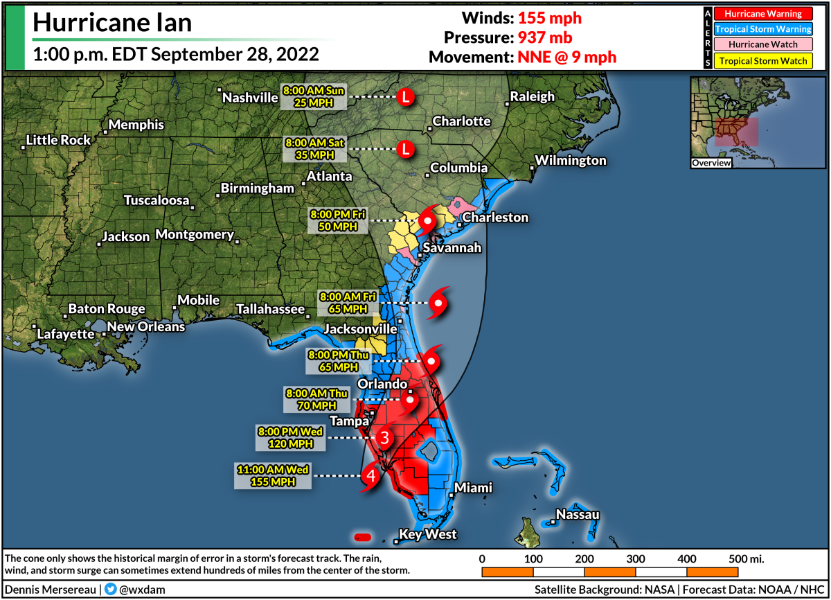
The only thing scarier than a strong hurricane threatening a major metro area is a strong and slow-moving hurricane threatening a major metro area.

Hurricane warnings are in effect for the Tampa Bay area this evening as Hurricane Ian makes a beeline for the area.

The storm is going to grow very strong by the middle of the week as it approaches Florida's west coast. As if that's not bad enough, the storm is also going to slow down to a crawl as it parallels the peninsula, prolonging the high winds, heavy rain, and storm surge to 24+ hours for many areas.


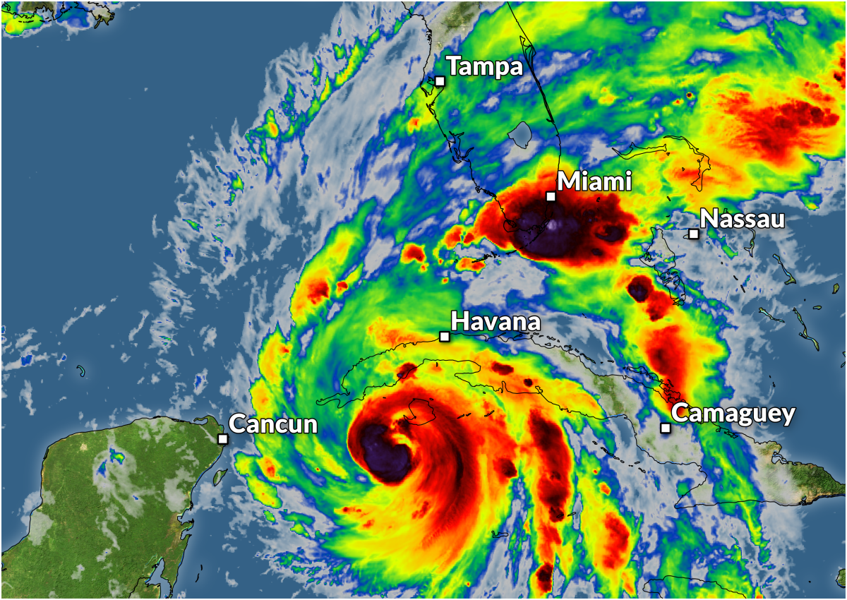
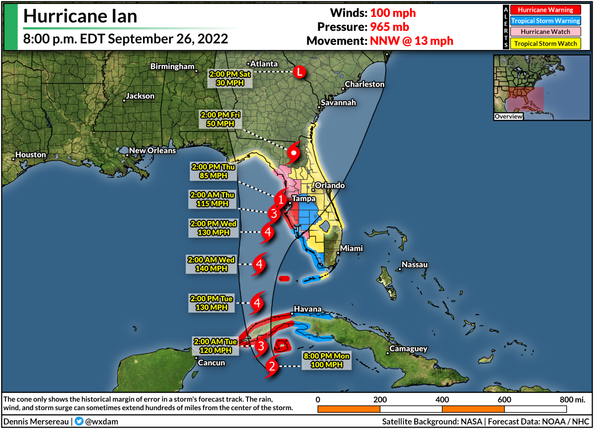
Hurricane Ian wound up in a hurry as it trekked through the western Caribbean Sea over the past couple of days. The storm is now a category two hurricane with maximum winds of 100 mph, and it's in a favorable environment for continued strengthening over the next couple of days.

The storm will make landfall on the western tip of Cuba overnight Monday before emerging in the southern Gulf of Mexico on Tuesday.

Forecasters with the National Hurricane Center (NHC) expect Ian to rapidly intensify as the storm hits the steamy waters of the southern Gulf, with the official forecast strengthening Ian into a frightening category four hurricane by Tuesday night.

Then the storm is going to hit the brakes.

SOURCE: Tropical Tidbits

A strong ridge of high pressure building over the Great Lakes will act like a barricade that will slow Hurricane Ian down to a crawl.

This thing is only going to be moving a couple of miles per hour as it approaches Florida's west coast. The forecast icons are practically on top of each other by the time the core of the storm is close to Tampa Bay.

Storm Surge

It may seem like a good thing that the storm isn't going to haul into Florida at full strength, but all things are relative with such a strong storm in such a vulnerable area.

SOURCE: National Hurricane Center

If the current forecast holds, this would expose the Tampa Bay area to the strongest part of the storm for an entire day or longer, funneling a deep and persistent storm surge into the bay and directly into the city of Tampa itself.

The NHC's storm surge forecast at 5:00 p.m. on Monday called for a 5-10 foot storm surge across the Tampa Bay area if the strongest winds in the storm coincide with high tide. This would be a destructive storm surge for coastal areas, and a double-digit surge would push well inland from the coast in spots.

Flooding Rains

Flooding from heavy and persistent rains is going to be one of the biggest impacts from this storm as it makes landfall and pushes inland through next weekend.


We could see rainfall totals of 6-12+ inches across the Florida peninsula during this storm. That much rain will easily overwhelm waterways and storm sewers, leading to flooding in vulnerable areas.

The heavy rain isn't going to stay limited to Florida, though. After landfall, Ian and its eventual remnants will slowly make their way into the southeast, where we're likely to see widespread heavy rain starting at the end of the week and lasting into the weekend.

A surge of tropical moisture riding on the back of a remnant storm is enough to prompt flooding rains under normal circumstances, but that same high-pressure system that will slow Ian to a crawl is also going to lead to a significant cold air damming (CAD) event across interior sections of the southeast.

SOURCE: Tropical Tidbits

Cold air damming occurs when northeasterly winds blow cool air up against the base of the Appalachian Mountains. The cold, dense air can't ride up and over the mountains, so it pools up across the piedmont region. It's infamously stubborn and approaching storms have a tough time scouring it away—warm air winds up riding up and over this dammed-up cold air, triggering widespread rainfall. 

A persistent conveyor belt of tropical moisture flowing up and over that cooler air at the surface will lead to several days of heavy rain, which could easily lead to flooding in vulnerable areas. There's also the potential for landslides in some of the Appalachians.

Winds

Hurricane-force winds are likely across the west-central Florida coast. Widespread and potentially long-lasting power outages are likely for the hardest-hit areas, especially if 100+ mph sustained winds manage to move ashore.


One of the most important preparations you can make for an approaching storm is getting ready for power outages. You never realize how underprepared you are until the lights go out.

Actual flashlights and battery refills are crucial so you don't waste your cell phone battery feeling your way around the bathroom.

Non-perishable, ready-to-eat foods like canned ravioli and fruit cups are a lifesaver when there's no power. It's tough to cook without electricity and the burger joints and coffee shops won't be open if they don't have power.

Tornadoes

As with any landfalling tropical system, a risk for tornadoes will spread inland as the storm very slowly approaches landfall over the next couple of days.


Tornadoes are common in the right-front side of tropical cyclones because there's ample low-level wind shear to spark rotation in thunderstorms embedded in the storm's outer bands. Tropical tornadoes happen very quickly, sometimes only allowing forecasters to issue tornado warnings with only a minute or two of lead time.

Make sure you have a way to receive tornado warnings the moment they're issued, and have a plan to get to safety as quickly as possible if you hear that your location is under a tornado warning. Take a look at your cell phone now to ensure that wireless emergency alerts are turned on for tornado warnings. Lots of folks shut them all off after one ill-timed interruption for an AMBER Alert.

Tampa's Century-Long Lucky Streak Looks Finished

Tampa is one of the only major coastal cities in the south that's been relatively lucky when it comes to hurricanes. Plenty of storms have come close and even tracked over the area. Hurricane Zeta made landfall north of the bay area as a tropical storm in November 2020.

SOURCE: NOAA

The last time a major hurricane came close to Tampa Bay was an unnamed storm back in 1921. That storm caused widespread destruction across the region. Hurricanes tend to miss Tampa because prevailing winds tend to force storms to hit Florida from the east, and (with one recent exception) storms approaching from the south typically only clip the area on their way to the northern Gulf Coast.

Geography isn't protection. All indications are that Tampa's century-long lucky streak on missing strong hurricanes is going to fall this week. Please heed the advice and orders of local officials if you live in a vulnerable area, and please let your friends and family in the area know that this is a serious situation.


You can follow me on Twitter or send me an email.

Please consider subscribing to my Patreon. Your support helps me write engaging, hype-free weather coverage—no fretting over ad revenue, no chasing viral clicks. Just the weather.


September 24, 2022

Tropical Storm Ian Could Hit Category Four Intensity In The Gulf This Week


It only takes one. 

The slow start to this year's Atlantic hurricane season may not be what we remember about this season after all. We're staring down the prospect of tracking our second major hurricane in a week, and this one could be a doozy for the Gulf states.

Tropical Storm Ian is a fledgling storm in the southern Caribbean Sea tonight. The system is still pretty weak, packing maximum winds of only 45 mph. However, the system is gradually getting better organized on satellite imagery—it certainly has "that look" to it—and it's moving into an environment favorable for strengthening.

Ian is about to move over the warmest water in the entire Atlantic Ocean. Here's a look at ocean heat content, which goes beyond sea surface temperatures to show the pool of warm water a developing tropical system can tap into:

SOURCE: NOAA

These waters have been relatively untouched by tropical systems this year, giving Ian first dibs on tapping into an entire summer's worth of hot sunshine beating down on these tropical waters.


The latest forecast from the National Hurricane Center calls for Ian to undergo rapid intensification through Tuesday, growing into a category four storm as it passes the tip of Cuba.

There's still plenty of uncertainty in the forecast. Rapid intensification is tough to forecast; it can catch us off guard as easily as a hiccup in the storm's structure can prevent that sudden jump in intensity.

There's also greater-than-normal uncertainty with Ian's future track. Model guidance has slowly ticked the storm's track farther and farther west with each update, which puts more of the northern Gulf Coast in line for the storm.

It's still too early to tell where it'll make landfall, but anyone from Gulfport to Fort Meyers needs to have a plan in place to deal with a strong hurricane in the Gulf by the middle of next week.


Regardless of its precise track, a hurricane entering the Gulf will have far-reaching consequences that extend far beyond the coast. The latest rainfall forecast from the Weather Prediction Center shows a widespread swath of very heavy rain falling over much of the southeastern states over the next week. We could also see a risk for tornadoes with the storm's remnants when/if they push inland.


You can follow me on Twitter or send me an email.

Please consider subscribing to my Patreon. Your support helps me write engaging, hype-free weather coverage—no fretting over ad revenue, no chasing viral clicks. Just the weather.


September 20, 2022

Powerful Hurricane Fiona Sets Its Sights On Bermuda And Atlantic Canada


Hurricane Fiona continues to strengthen in the western Atlantic Ocean after unleashing catastrophic flooding across Puerto Rico this weekend, causing widespread damage and knocking out power to the entire island at one point.

The major hurricane will brush Bermuda on Thursday night before setting its sights on Atlantic Canada by this weekend.

We saw catastrophic flooding and widespread wind damage across Puerto Rico as the hurricane made landfall on the hard-hit U.S. territory on Sunday. The entire island lost power at one point as the hurricane made landfall, and 80 percent of the island remained without power as of Tuesday night, according to data collected by PowerOutage.US


Southern portions of the island recorded more than two feet of precipitation as a stationary band of torrential rainfall trained over the island for hours on end as the storm made landfall and pulled off to the northwest. This stationary feeder band is similar to the feature that caused historic flooding in southeastern Texas during Hurricane Harvey in 2017.

Things have finally cleared out in Puerto Rico for residents to begin the months-long task of cleaning up from this latest disaster.

Hurricane Fiona remained a category three hurricane at the National Hurricane Center's 5:00 p.m. update on Tuesday, packing maximum sustained winds of 115 mph. The storm is slowly pulling away from land after spending most of the day producing hurricane conditions across the Turks and Caicos Islands.


Favorable conditions across the western Atlantic should allow Fiona to strengthen into a powerful category four hurricane during the day on Wednesday as it turns north-northeast and begins to pick up some speed.

This track will bring the hurricane uncomfortably close to Bermuda, where a tropical storm watch is in effect for Thursday night and Friday morning. Fiona could bring high winds, heavy rain, and dangerous seas to the tiny island nation. 

Things are going to go from bad to worse once Fiona clears Bermuda.

A trough swinging across eastern North America will meet up with the hurricane on Friday, grabbing the storm and pulling it into Atlantic Canada.

SOURCE: Tropical Tidbits

Hurricane Fiona will begin extratropical transition once the trough grabs hold of the storm, meaning that it will lose its tropical characteristics, develop fronts, and derive its energy from the jet stream instead of thunderstorms in an eyewall.

When this transition occurs, the NHC will designate this system "Post-Tropical Cyclone Fiona," but that's just a bureaucratic title. Models suggest that Fiona's minimum pressure will drop even further during and after this transition, expanding its wind field without losing much of its ferocity.

While the exact track will shift around before Fiona makes its final approach—something we'd expect 4-5 days out, of course—it appears very likely that the storm is going to bring significant wind and flooding impacts to Nova Scotia and Newfoundland by this weekend. Fiona's growing footprint will lead to major impacts even far away from the center of the storm.

If you live in Atlantic Canada, now is the time to prepare for widespread and long-lasting impacts from a high-end storm, the likes of which you don't see very often around here. Grabbing a couple of bags of storm chips won't cut it if the power goes out for a prolonged period of time.


You can follow me on Twitter or send me an email.

Please consider subscribing to my Patreon. Your support helps me write engaging, hype-free weather coverage—no fretting over ad revenue, no chasing viral clicks. Just the weather.


September 15, 2022

Tropical Storm Fiona Threatens Caribbean Flooding, Worth Watching In U.S. Next Week


Tropical Storm Fiona is an interesting lump of clouds a few hundred miles east of the Caribbean this evening. The storm, which is only the sixth we've seen in this surprisingly sluggish season, will bring heavy rain to the Greater Antilles through the weekend before turning north.

Fiona isn't the healthiest tropical storm despite the bite of its 60 mph winds. The system has a strong center of circulation at the surface, and we know that because the center is completely exposed thanks to westerly wind shear. The naked li'l swirl is flanked by decent thunderstorms on the eastern side of the storm.


The tropical storm will struggle a bit as long as westerly wind shear forces it to run around like an atmospheric nudist. However, disheveled storms can be deceiving, and Fiona will pose a significant risk for flooding and mudslides across portions of the Greater Antilles through the weekend.

Tropical storm watches and warnings are in effect for these islands ahead of Fiona's arrival. The risk for gusty winds will take a backseat to the risk for flooding as the system passes through the region.


Puerto Rico and the Dominican Republic are in line for particularly heavy rains, which could amount to 6-12+ inches in spots by the time the storm turns north and pulls away from the region early next week. It doesn't take much heavy rain to cause problems in this part of the world, and a slow-moving drencher of a tropical storm will easily lead to widespread flash flooding and mudslides.

Things get a little fuzzy once the storm curves northward. The most likely scenario is that Fiona, like most storms that follow its general track, will recurve out to sea and only threaten Bermuda. However, weather models are hinting at the possibility that a ridge of high pressure over the eastern United States or western Atlantic will prevent the storm from performing a clean recurve.

Fiona's future track seems to rely heavily on its intensity. We often see this in storms that approach the Caribbean during the peak of the season. A weaker storm is driven by winds lower in the atmosphere, which allows easterly winds to force the storm west toward land. A stronger storm can capture winds through a deeper slice of the atmosphere, usually pushing the storm north and curving it out to sea.

It's wayyyy too early for details—and chuck tomatoes at anyone pretending otherwise—but it's wise for folks across the East Coast to keep this storm on their radar and make sure their plans and supplies are up to speed in case this storm starts trending westward.

[Satellite imagery via NOAA]


You can follow me on Twitter or send me an email.

Please consider subscribing to my Patreon. Your support helps me write engaging, hype-free weather coverage—no fretting over ad revenue, no chasing viral clicks. Just the weather.


September 5, 2022

All-Time Heat Records Fall As Major West Coast Heat Wave Continues


A historic heat wave over the West Coast that's shattered longstanding daily, monthly, and all-time records is going to stick around for a while longer.

If the observations are valid, Sacramento International Airport's high temperature of 117°F on Monday afternoon is the hottest temperature ever recorded in California's state capital. The previous all-time record high was 115°F on June 15, 1961.

SOURCE: NWS

This is an unprecedented heat wave for folks out west. It's obvious that this is a high-end heat wave for the western United States, but the fact that this is happening in September is almost more unusual than the temperatures themselves.

Take a look at this animation (from coolwx.com) showing all of the temperature records broken over the 24 hours between Sunday evening and Monday evening:

SOURCE: coolwx.com

All of the pink dots nestled inside of a white circle are all-time monthly records—the hottest temperatures ever recorded in the month of September.

The circles with a big black X are the hottest temperatures ever recorded at that station. Look closely at the end of the animation to see multiple X marks pop up over California.

This heat isn't over yet. Tuesday will see another day of record-breaking temperatures across the western United States.

Here are the National Weather Service's predicted high temperatures for Tuesday:


A historic heat event is bad enough on its own, but there are three factors exacerbating the impacts of this particular nightmare.

1) it's been hot for a long time, and it'll be hot for a while yet. The heat will stick around through the end of the week for many spots as this powerful ridge of high pressure remains parked west of the Rockies;

2) excessively hot days are bad enough, but low temperatures at night aren't providing much relief to folks who don't have adequate means of cooling off. The compounding stress of hot days and stifling nights can (and will) lead to medical emergencies and possible fatalities;

3) and the fact that it's not exactly a dry heat, especially in southern California. The dew point is in the 60s for many folks in the Los Angeles area, for instance, which is muggy anywhere, but especially for an area that's not used to a humid heat.


We'll finally see the ridge begin to break and weaken toward the end of the week as a result of Hurricane Kay in the eastern Pacific. This storm is on track to follow the Baja California Peninsula through the week, eventually slowing down and turning west by this weekend as it reaches the northern extent of the peninsula.

Of course, this is being spun into "A HURRICANE IS HEADING FOR CALIFORNIA!!!" by folks jonesing for sweet, sweet social media clout. Conditions are too unfavorable for just about any storm to make it to California as a tropical entity—that's why there's only something like one hurricane on record that's ever hit the state.

The system's moisture will reach southern California, though, and that'll bring some challenges of its own. Some spots could see several inches of rain next weekend amid the influx of tropical moisture. This would reduce temperatures, but it would also lead to a risk for flash flooding and mudslides, especially on and around burn scars.


It remains to be seen how far north into California we'll see the tropical moisture reach. A deeper push would provide a better chance for rain across areas that desperately need the relief right now. However, there's also a chance that this setup could lead to thunderstorms, leading to an increased potential for wildfires. This risk will crank up dramatically if these turn out to be dry thunderstorms.

Keep a close eye on the forecast heading into this weekend. As always, whether it's flooding or wildfires or any sort of disaster, make sure your emergency plans and supplies are taken care of long before your home is under threat.


You can follow me on Twitter or send me an email.

Please consider subscribing to my Patreon. Your support helps me write engaging, hype-free weather coverage—no fretting over ad revenue, no chasing viral clicks. Just the weather.