May 29, 2022

Agatha To Hit Mexico As A Major Hurricane, Gulf Development Possible Next Week


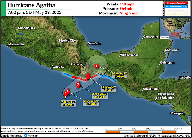
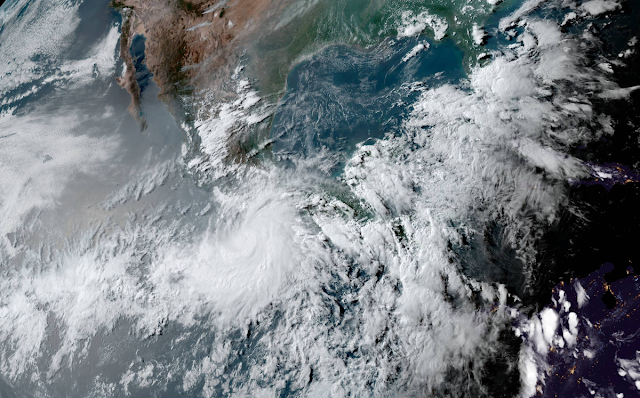
The first storm of the 2022 eastern Pacific hurricane season is going to be a doozy for folks along the southern Mexican coast. Hurricane Agatha is on track to make landfall as a major category three storm late on Monday, bringing prolific rainfall and destructive winds to the Oaxacan coast.

From there, the system's remnants could redevelop in the Gulf of Mexico as we head into the first week of June.


The latest advisory from the National Hurricane Center found Hurricane Agatha on the cusp of major hurricane status. The storm had maximum sustained winds of 110 mph as it crept northeast toward the Oaxacan coast. Hurricane warnings are up for Puerto Escondido and Salina Cruz as the system's powerful core draws closer to land.

Hurricane Agatha's intensity, slow movement, and the region's mountainous terrain will combine to lead to a life-threatening risk for flash flooding and mudslides along the storm's track.

The NHC's advisory on Sunday evening called for widespread rainfall totals of a foot or more, with some areas potentially picking up as much as 20 inches of rain by the end of the storm. Most tropical cyclone deaths in this region are the result of flooding and mudslides.


Agatha is going to weaken quickly after it makes landfall, winding down to a remnant low by Tuesday. After that, we'll have to keep an eye on the hurricane's remnants for potential redevelopment in the Gulf of Mexico or western Caribbean by the middle of next week.

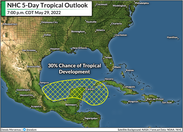
The NHC's tropical weather outlook calls for a 30 percent chance of tropical development over the next five days. Models are consistently showing...something...forming in the region and heading toward southern Florida.

Whether or not it's a full-blown tropical system or just a disturbance remains to be seen, but regardless of development, this surge of tropical moisture will contribute to more heavy rain over southern Florida.


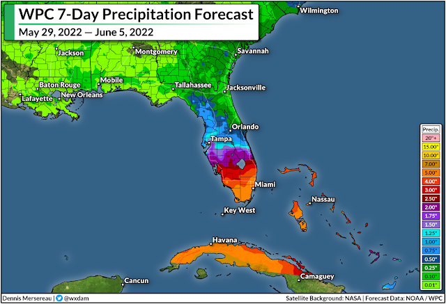
The Weather Prediction Center's precipitation forecast for the next seven days calls for 5+ inches of rain across southern Florida, and that's on top of the heavy rain that's fallen in today's heavy thunderstorms.

These totals are likely to fluctuate over the next few days as forecasters get a better handle on the system's ultimate track and development. A stronger, more organized system could produce more rainfall.

While there are abnormally dry and moderate drought conditions scattered throughout the southern half of Florida, this much rain falling in such a short period of time does more harm through flooding than good through drought amelioration.


Hurricane season officially begins on June 1st. It looks like this is going to be the first hurricane season in seven years not to start in May or earlier.

Even though we didn't get a head start for the first time in a long while, forecasters expect an active hurricane season thanks to La Niña over in the eastern Pacific. Cooler sea surface temperatures in the eastern Pacific serve to lessen wind shear over the Atlantic basin, creating more favorable conditions for tropical development throughout the season.


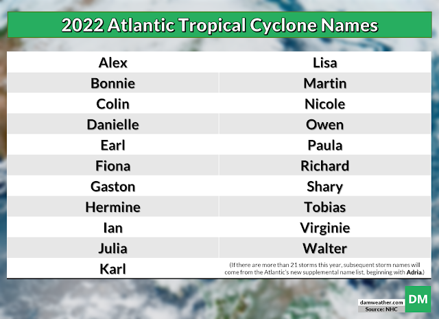
This year's list of hurricane names was last used in 2016. The first storm on the list will be Alex, followed by Bonnie and Colin. The names Martin and Owen are new this year, replacing Matthew and Otto, which were retired after the 2016 hurricane season.

If we see more than 21 storms before the end of the year, we'll roll over to the new supplement list of storm names, beginning with the name Adria. The World Meteorological Organization nixed the use of Greek letters to name excess storms after the historic 2020 hurricane season.


You can follow me on Twitter or send me an email.

Please consider subscribing to my Patreon. Your support helps me write engaging, hype-free weather coverage—no fretting over ad revenue, no chasing viral clicks. Just the weather.


May 15, 2022

Damaging Wind, Tornado Risk Targets East Coast States On Monday


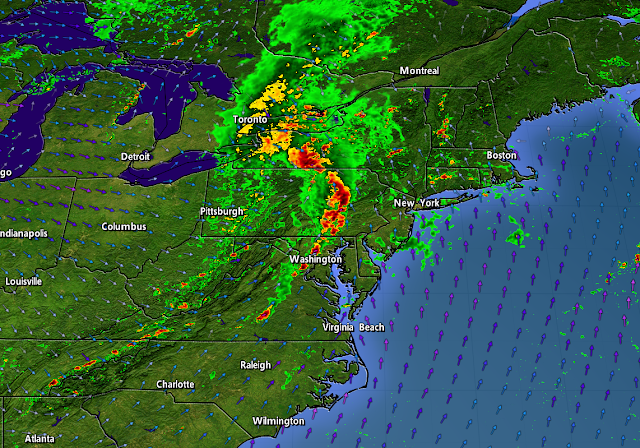
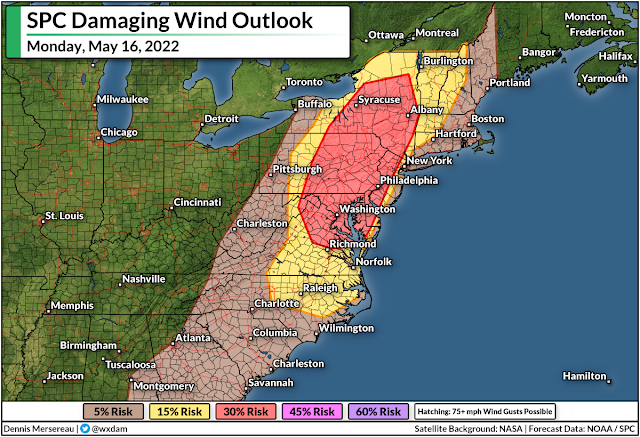
A widespread threat for severe thunderstorms will cover much of the East Coast on Monday as a cold front plows into the heat and humidity that's parked over the region in recent days. The storms could bring damaging wind gusts, a few tornadoes, and some instances of large hail. Make sure you've got a way to receive warnings the moment they're issued.

A trough swinging over the Great Lakes will allow a low-pressure system to develop across eastern Ontario and southern Quebec during the day on Monday. A cold front extending off this budding low will set the stage for a broken line of thunderstorms to sweep across the eastern states.


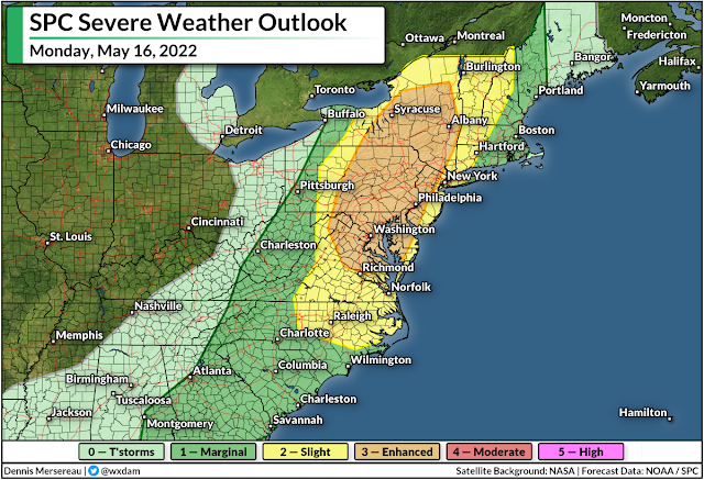
There's enough instability and wind shear for these thunderstorms to turn severe. The Storm Prediction Center issued a wide-ranging risk for severe weather on Monday, covering everyone from southern Georgia to interior Maine.

The greatest risk for severe weather—an enhanced risk, or a three out of five on the scale—will stretch from central Virginia to northern New York, including the metro areas of Washington, Baltimore, Philly, Syracuse, and Albany. The severe risk extends west to the mountains and east to include the entire I-95 corridor from Savannah up to Portland.


For most folks, the risk for damaging wind gusts of 60+ mph will be the predominant threat. However, folks in and around the enhanced (orange) and slight (yellow) risk zones could see a few spin-up tornadoes along the leading edge of any squall lines that move through.

Keep an eye out for alerts and prepare to act quickly if your location goes under a tornado warning. Take a second to check your phone and make sure emergency alerts are activated for tornado warnings.


It's worth pointing out for our friends up north that the threat for damaging winds and a tornado or two will extend into portions of eastern Ontario and southern Quebec, as well. This risk includes the National Capital Region, Montreal, and the Eastern Townships on Sunday afternoon and evening.

Conditions will calm down behind the front. Folks in the northeast will see a couple of days of cooler-than-normal temperatures before the heat starts to build back in toward the end of the week. Folks south of the Mason-Dixon line are looking forward to daytime highs in the 90s beginning Wednesday and lasting into the weekend.

[Top image created using WSV3]


You can follow me on Twitter or send me an email.

Please consider subscribing to my Patreon. Your support helps me write engaging, hype-free weather coverage—no fretting over ad revenue, no chasing viral clicks. Just the weather.
  

May 7, 2022

Back To The 90s: Summerlike Heat To Build Across The Central U.S. This Week


Whew. The season's first solid burst of summerlike heat will build across the central United States this week. It's already pretty darn hot down in Texas on Saturday, where highs climbed into the triple-digits for western parts of the state. The heat will spread toward the Great Lakes as the week wears on.

Much of the weather across the United States this week will be dominated by an 'Omega Block,' a type of pattern that essentially creates a stagnant upper-level roadblock.

An Omega Block, earning its name from the resemblance to the Greek letter Omega Î© on weather maps, forms when a ridge of high pressure is bookended by two upper-level lows.

Meteorologists commonly describe these blocking patterns as "what you see is what you get," as conditions remain largely the same for days on end until the block wears off and things start moving again.

Source: Tropical Tidbits

The pattern we're stuck with this week will see calm and hot conditions build beneath the ridge parked in the center of the country, while both coasts deal with cool and dreary conditions courtesy of those stubborn upper-level lows.

In fact, the low off the southeast coast will retrograde and move back toward Florida this week, bringing the Sunshine State some showery weather, slightly lower humidity, and below-seasonal temperatures toward the middle and end of next week.

The big story, though, will be the hot weather building into the central U.S.

Temperatures already soared into the 100s for a large portion of Texas, where the National Weather Service issued widespread heat advisories to alert people to the potentially dangerous heat.

It's likely that these heat advisories will spread north toward the Midwest tomorrow and early this week as daytime highs soar into the 90s.

Here's an animation showing the National Weather Service's predicted highs between Saturday, May 7th, and Friday, May 13th. This .gif switches to the next map every two seconds before looping back at the end.


Highs in the 100s will push through much of northern and western Texas again on Sunday and Monday, with daytime temperatures in the mid- to upper-90s making their way into Oklahoma and Kansas.

We'll see upper 80s and low 90s creep toward the Midwest by the middle of the week, with a high of 89°F in Minneapolis by Thursday. This would be the city's warmest temperature since September 19, 2021.

As always, be mindful of the toll the heat can take. It's easy to overdo it without realizing you've overdone it until it's too late and you're feeling ill from heat exhaustion or worse. 

Meanwhile, you can see the influence of the meandering upper-level lows on each coast, with stubbornly cool temperatures bathing the coasts. It's especially pronounced across the east, where cold air damming will keep highs in the 50s into the Carolinas on Sunday, with the immediate shoreline from Cape Cod to the Outer Banks struggling to get out of the 60s until Thursday.

The good news with a pattern like this is that it minimizes the risk of widespread organized severe weather. We'll take any chance we can get to skip through a week in May without raucous severe storms raging somewhere.


You can follow me on Twitter or send me an email.

Please consider subscribing to my Patreon. Your support helps me write engaging, hype-free weather coverage—no fretting over ad revenue, no chasing viral clicks. Just the weather.