December 31, 2022

New Year's Winter Storm Threatens Blowing Snow, Severe Storms, Significant Warmth


A developing winter storm will tick almost every box on the hazards checklist to start the first week of the new year as a low-pressure system strengthens over the center of the country.

The system is over California right now, bringing plenty of much-needed rain to lower elevations and very heavy snowfall to the mountains. This low will traverse the Rockies this weekend, eventually emerging over the Plains on Monday as a fast-developing Colorado low.

We'll see widespread winter weather across northern sections of the Rockies and the Plains through Tuesday, with several feet of snow falling at the peaks and a decent, shovelable snowfall for areas like Denver, Boulder, and Cheyenne. Freezing rain and sleet are possible closer to the track of the low.

Snow and a wintry mix will continue into the Upper Midwest as the storm peaks in strength as it pushes into the Great Lakes on Tuesday.


Southerly winds pulling into the storm will drag warm, humid air deep into Canada as the low strengthens and moves through, bringing very warm temperatures to just about everyone in the eastern half of the U.S.

The calendar may say January, but the thermometer is going to scream April. Tuesday's highs will climb into the 70s as far north as West Virginia, with 60s reaching western New York—still buried under many feet of snow from last week's blizzards.

A few inches of rain could fall through early next week with this system. The rapid warmup and arrival of heavy rain could lead to flooding in areas where the ground is frozen or there's still significant snowpack from last week's storm and lake-effect bonanza.


Farther south, the system's cold front plowing into that warm and humid airmass will trigger a round of severe thunderstorms across the Deep South on Monday.

The greatest threat appears centered on the Arklatex region, with the threat stretching out to include Little Rock and Shreveport. These areas could see the threat for "potentially significant damaging gusts and a couple of strong tornadoes," the Storm Prediction Center said on Saturday.


Colder air will move in for a couple of days behind the system, but it's not going to last too long or get too cold. In fact, winter's deepest chill seems like it wants to chill out on the northern Plains for the next couple of weeks, sparing the rest of us with milder conditions through the first half of the month. (And even there it'll be warmer than normal.)

The Climate Prediction Center's latest outlook through January 13th tells the tale—decent odds of warmer-than-normal temperatures for almost everyone. Ahh, winter.

[Top Map: NOAA/WPC]


You can follow me on Facebook, Mastodon, Twitter, Instagram, or send me an email.

Please consider subscribing to my Patreon. Your support helps me write engaging, hype-free weather coverage—no fretting over ad revenue, no chasing viral clicks. Just the weather.


December 21, 2022

What You Need To Know About This Dangerous Pre-Christmas Cold Snap & Snowstorm


It's pouring out of the northern Plains like an avalanche.

The temperature in Wheatland, Wyoming, on Wednesday dropped from 45°F at 9:50 a.m. local time to just 6°F by 10:30 a.m., falling further to -6°F by 12:50 p.m.

This week's remarkable crush of Arctic air will pick up speed as it hurtles toward the eastern two-thirds of the United States over the next couple of days.

Our cold front will race down the Plains through Thursday, the slug of frigid air curving eastward as a low-pressure system develops over the Midwest.
The WPC's forecast for the morning of Friday, December 23rd.


This low will slingshot the cold toward the eastern states on Thursday and into Friday morning, bitter air riding in on southwesterly winds for many folks courtesy of the vigorous flow spiraling around the center of the storm.

Many folks across the east will see Friday's high temperature happen either at midnight or during the early morning hours. This cold front will pack a punch all the way to the Atlantic, sending temperatures plummeting dozens of degrees in a matter of minutes.

The arrival of dangerous, life-threatening cold doesn't even begin to touch this pre-Christmas storm's other hazards.

Cold Temperatures

Extreme cold is nothing to scoff at. A cold snap like this can injure or kill hundreds of people through frostbite and hypothermia.

The same elderly, poor, unhoused, or chronically ill people who struggle through extreme summertime heat are vulnerable to frigid cold snaps like the one descending on the U.S. this week.


A vast swath of the country will face several straight days of subzero—and, for even more, subfreezing—temperatures heading into the Christmas weekend. That's cold for anyone no matter how acclimated you are to winter weather.

Unprotected skin can begin to freeze in as little as 30 minutes when temperatures or wind chill values dip below zero. Frostbite is possible in a short while with readings in the double-digits below zero.

Frigid temperatures will easily reach the Gulf Coast over the next couple of days, with morning low temperatures into the lower 20s spreading over the Florida Panhandle. Temperatures below freezing will reach the Orlando metro area, and Miami is expecting a chilly low temperature of 47°F by Christmas morning.


Wind chills will be even colder. Widespread wind chill warnings blanket the country from the Canadian to the Mexican borders.

No matter how much people fake-knowingly snicker at the idea, the wind chill isn't made up.

Scientists developed the wind chill by studying how cold temperatures and wind affect the human body. Gusty winds on a frigid day chill your skin faster than your body would otherwise lose heat if it wasn't windy out. A wind chill of -15°F means that the combination of cold air and gusty winds has the same effect on your body as an actual air temperature of -15°F.

Take this cold snap seriously. Cold air is bad enough, but it'll be life-threatening for much of the country when you factor in the winds.

Flash Freeze

Most folks are going to see rain before the cold front roars overhead and temperatures plunge below freezing. Those wet roads and sidewalks won't have a chance to dry off before the frigid air arrives, leading to a dangerous and widespread risk for a flash freeze.

We're used to dealing with patches of black ice during the winter months, but a flash freeze is like if everything turned into black ice. A flash freeze on a major highway can cause significant pileup accidents.

If you're travelling or heading home from work or school over the next couple of days, make sure you're where you need to be once the cold temperatures hit—otherwise, you might get stuck wherever you are for a while.

Blizzard Conditions

Areas where precipitation follows the arrival cold temperatures will see heavy snow.


The heaviest snow will fall across the Great Lakes where the extreme temperature gradient between the relatively warm water and bitterly cold air will allow the lake-effect snow machine to crank at full capacity, especially off of Superior and Michigan.

Several inches of snow are possible across a widespread area from the central Plains toward the Northeast. It's not going to be a blockbuster snowstorm away from the Lakes, but the very cold temperatures will make this a fine, powdery snow—perfect for blowing around.

Very strong winds will develop as the cold air floods in and the accompanying low-pressure system strengthens over the Great Lakes. Even if you're only expecting a few inches of snow from this system, the powdery snow will easily blow around in the blustery winds, leading to whiteout or near-whiteout conditions for a very large area.

NWS wind gust forecast for 10:00 a.m. EST on Friday, Dec. 23, in knots. (For reference, 30 knots is about 35 mph, and 40 knots is 46 mph.)

It's likely that driving will be nearly impossible at times throughout the central U.S. heading into this weekend. If you can avoid it, don't go driving anywhere when it's snowing. You really, really, really don't want to get stuck on an impassable highway when temperatures are near or below zero.

It's likely that the snow and winds will cause widespread delays and cancellations at the region's major airports, including Chicago, Detroit, Pittsburgh, and Toronto. Bad weather affecting major hubs around a holiday is a recipe for hundreds (if not thousands) of delayed or cancelled flights.

Anticipate having to make alternate arrangements in a hurry, even if you're not flying through the affected areas. All planes have to come from somewhere, and if your plane gets stuck up the line at a snowed-in hub, you're not flying anywhere anytime soon.

Beware The Risk For Power Outages

The same high winds that will lead to dangerously cold wind chills and blizzard conditions could also lead to power outages. There aren't really any good times for the power to go out, but the power going out during a life-threatening cold snap is exceptionally bad.

Make sure you've got enough to eat, flashlights to feel around at night, rechargeable battery packs for cell phones, and plenty of blankets just in case the high winds (or demand on the grid) cause power outages.


You can follow me on Facebook, Mastodon, Twitter, Instagram, or send me an email.

Please consider subscribing to my Patreon. Your support helps me write engaging, hype-free weather coverage—no fretting over ad revenue, no chasing viral clicks. Just the weather.


December 18, 2022

100+°F Temperature Gradient Likely As Extreme Pre-Christmas Cold Snap Hits U.S.


You know it's going to be a heck of a cold front when there's a 99-degree temperature difference between Glasgow, Montana, and Miami, Florida, in the middle of the day.

A brutal blast of Arctic air will pour south out of Canada this week and plunge almost all of the eastern two-thirds of the United States into an extended cold snap.

That Glasgow-Miami difference isn't even the worst of it. It's likely that we'll see a >100°F spread between the warmest high temperature and the coldest high temperature in the U.S. at some point on Thursday or Friday.

Temperatures won't climb much above the single digits, let alone the freezing mark, over a vast swath of the country for a couple of days this week.

The P***r V****x

This pre-Christmas cold spell comes courtesy of a splintered piece of the polar vortex—that terrifying, mythical wintertime creature that lurks in the "favorites" list of every broadcast news computer's scary graphics folder.

The polar vortex is an ever-present belt of winds that wraps around the North Pole, growing to its peak strength every winter. This circulation keeps winter's coldest air confined to the Arctic when it's strong and well-behaved.

SOURCE: Tropical Tidbits

However, the circulation becomes unstable from time to time, allowing troughs or upper-level lows to swoop down to lower latitudes. These "pieces" of the polar vortex bring bitterly cold air south with them. 

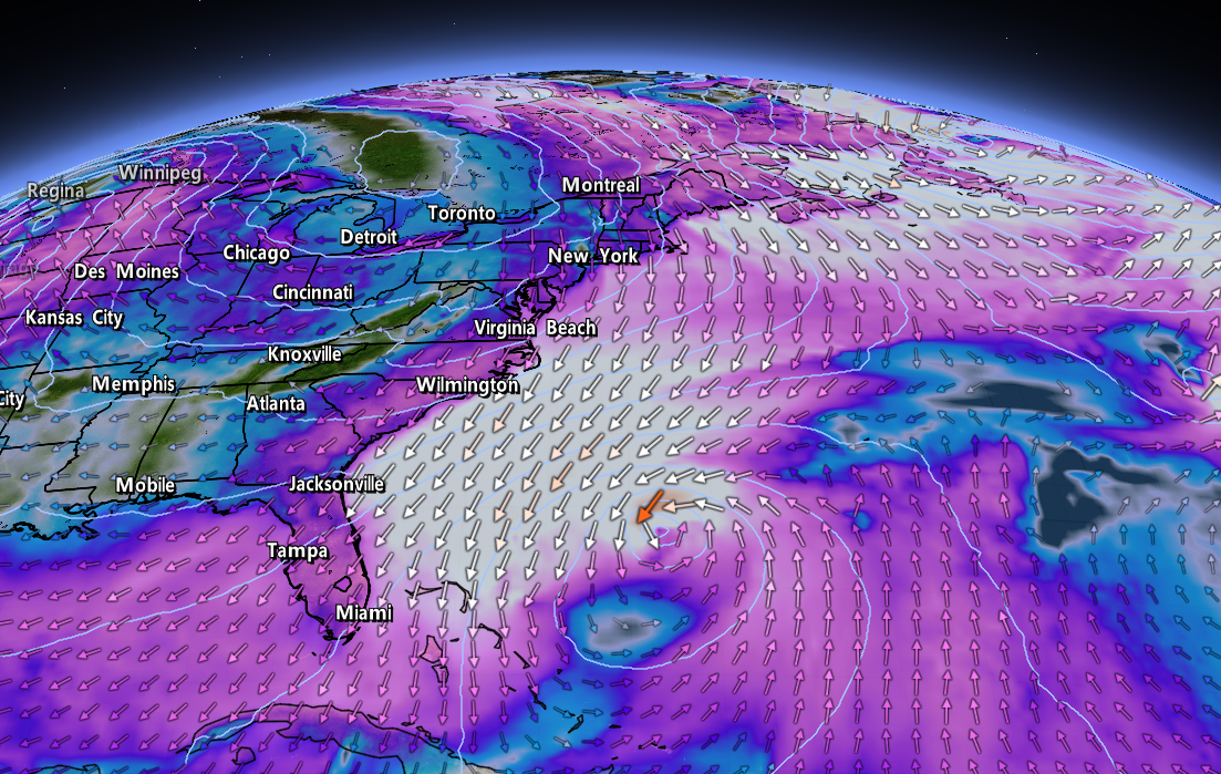
Our looming surge of Arctic air will come courtesy of an upper-level low that was once a part of the polar vortex's broader circulation over far northern Canada.

Not only will this low pull frigid air as far south as Florida and southern Texas, but this setup will generate a low-pressure system at the surface.

This developing late-week storm will bring a major bout of wind and wintry precipitation just in time to mess up everyone's holiday travel plans across the Midwest, Great Lakes, and Northeast.

The Cold

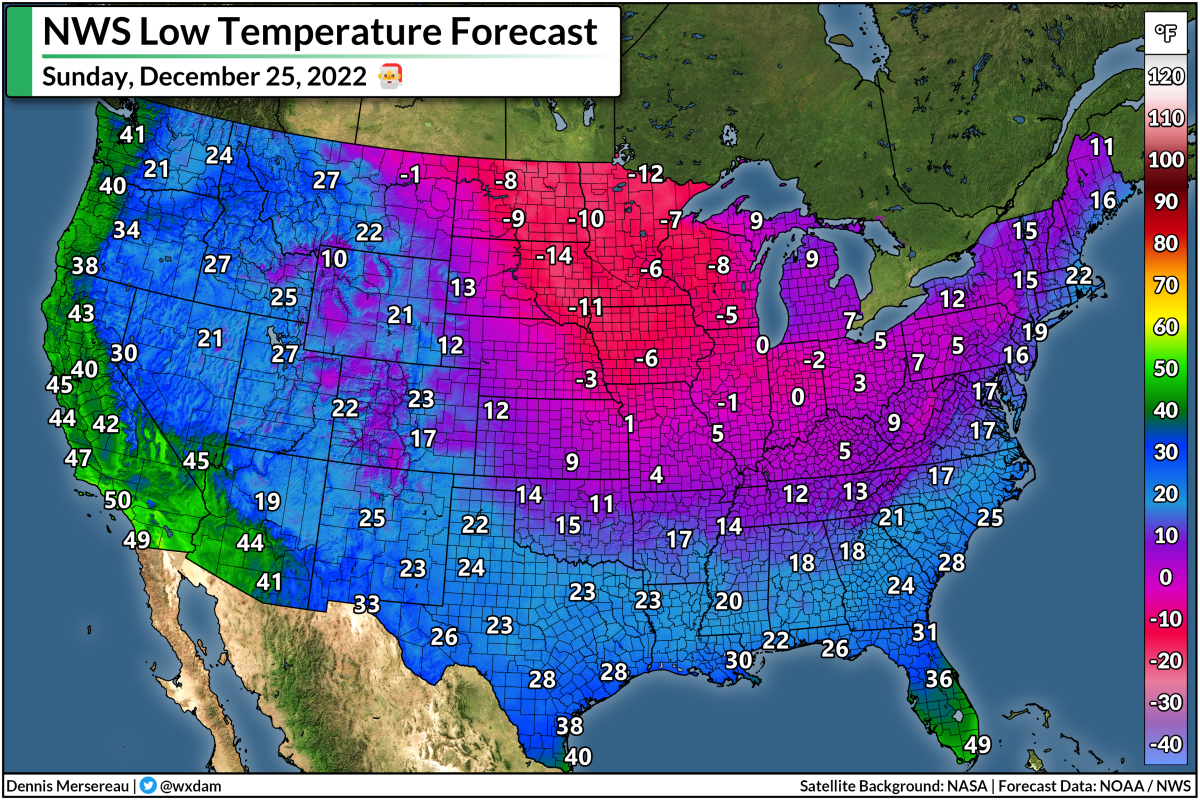
Subzero temperatures were firmly locked in place across the northern Plains on Sunday night, and temperatures will remain in negative territory for a full week from the northern Rockies to the Upper Midwest.

Wind chill values will drop well below -40°F during the worst of the cold across this region. That's dangerous cold even for the hardiest Plains resident who boasts about their fortitude. Actual air temperatures below -30°F, and wind chill values below -40°F, can lead to frostbite and hypothermia in a matter of minutes. It's serious stuff.


This unpleasantly cold air will steadily march southward over the next couple of days, forcing daytime highs to remain well below the freezing mark—even into the single digits or below zero—as we head through the middle of the week.

Thursday will see the most extreme temperature gradient across the country as our big storm system begins to develop across the Midwest.

Miami will bask in a high of 81°F on Thursday afternoon, while Glasgow, Montana, will only hit a balmy -18°F.


Overnight lows into Friday morning will be downright rude, with -30s widespread in the Dakotas, subzero readings into Oklahoma, and single digits as far south as northern Mississippi and Texas' Big Bend region.

It'll finally take until the night before Christmas for the cold front to reach the Atlantic coast, and all through the country it'll be...really darn cold.


Temperatures will dip into the 40s down in the Everglades, and lows on Christmas morning will even get into the lower 20s across the northern Gulf Coast. (22°F is frigid for Mobile, Alabama, y'all.)

Conditions will gradually improve and warm toward some semblance of normal during that vaporwave week between Christmas and New Year's when existence is a simulation and nobody actually gets anything done except for eating cookies and reading best-of-2022 listicles.
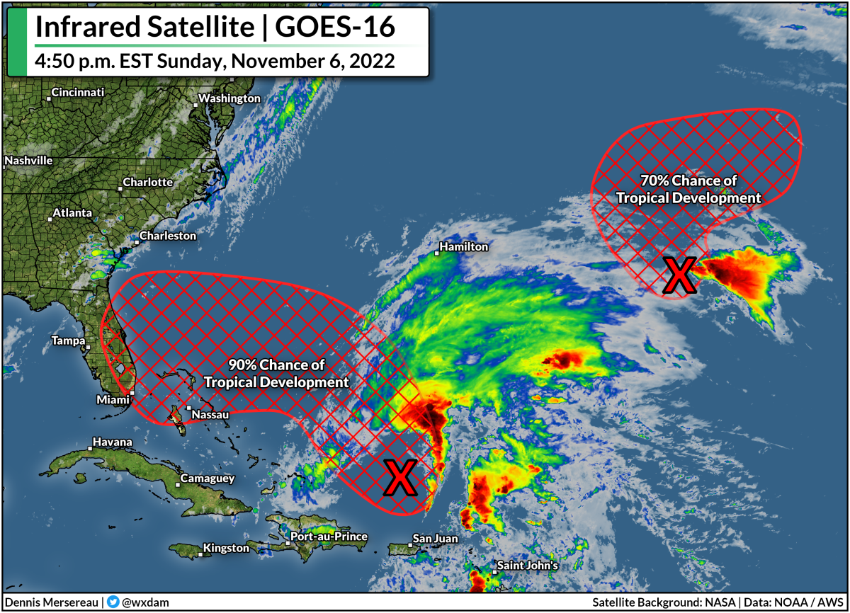
The Storm

Ohhh, the storm.

You've probably heard about it on Facebook or Mastodon or the failing tweeting bird app in the past week:

"It's a blizzard. It'll be a behemoth. It'll rival your grandparents' best childhood memories."

It's going to be a doozy for somebody, for sure. If you live along the East Coast, though...it's probably not gonna be you.

SOURCE: NWS/WPC

Models this weekend came into a bit of agreement that this low will track along or west of the Appalachian Mountains, which is great news for snow lovers in the Midwest and Great Lakes, and a nightmare scenario for the same group of folks along the I-95 corridor.

It's still too early to call out specifics like snow totals, ice accretions, or even which cities are going to get walloped the hardest. (It's at least four days away. For real. C'mon.) But the signals are all there that this is likely going to be a high-impact event for lots of major cities, including Chicago, Detroit, and Toronto.

Forecasters are already starting to use phrases like "blizzard conditions" for some areas, so this storm—regardless of its precise track—will have significant impacts on cross-country travelers heading out by road, rail, or plane.

Keep in mind that foul weather at air traffic hubs will have downstream ripple effects that affect flights that won't ever touch a snowy runway. (Every plane comes from somewhere else, after all.)

We'll have a better idea of what that storm will look like as we make our way through the week. Models will jump back and forth with its location a bit. Remember that only a few dozen miles to the east or to the west can have huge implications for the impacts of a winter storm.

The best thing to do now is to make flexible travel plans (a polite way of putting it) and try keep a jolly demeanor about whatever blows our way. We'll remember this ordeal fondly come July when we're breaking all-time heat records again.

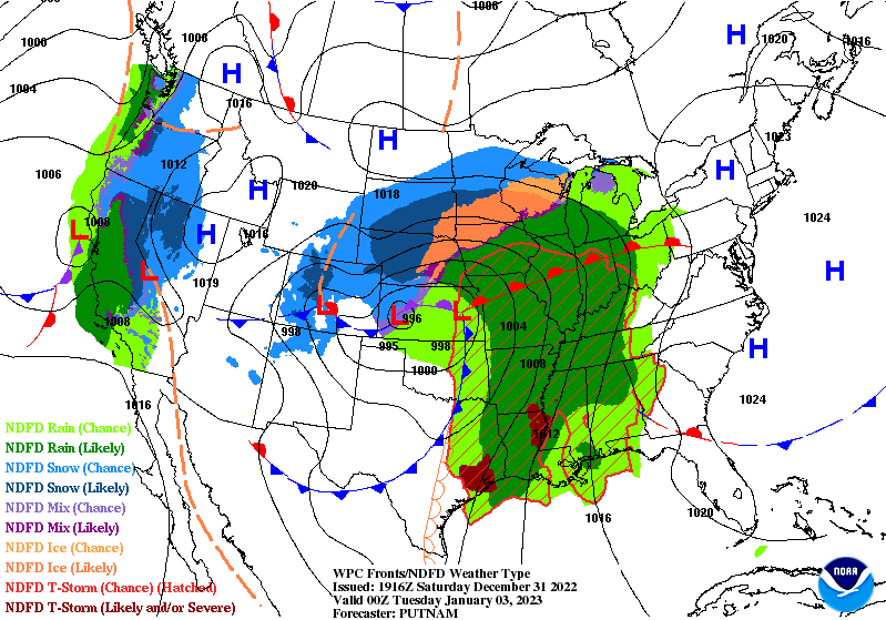
[Top image created using WSV3.]


You can follow me on Facebook, Mastodon, and Twitter. You can also send me an email.

Please consider subscribing to my Patreon. Your support helps me write engaging, hype-free weather coverage—no fretting over ad revenue, no chasing viral clicks. Just the weather.


December 12, 2022

Major Storm Threatens Blizzard, Ice Storm, Tornadoes, Heavy Rain...You Name It


The first real rip-roarin' winter storm of the season is cranking up over the Plains states this evening.

The storm will kick into high gear heading into Tuesday, bringing blizzard conditions and a full-on ice storm to parts of the High Plains, while folks across parts of the south have to deal with the risk for severe thunderstorms and tornadoes.

A fast-developing low over northeastern Colorado will strengthen over the next 12-24 hours as a strong jet stream moves across the Rockies.

This large system will have a little bit of everything for everyone—it'll be one of those classic winter storms that puts on a gorgeous curly display when we gawk at satellite imagery on Tuesday and Wednesday.

The northern side of the storm will have plenty of cold air for heavy snow and freezing rain to fall over the northern Plains.

Forecasters expect the worst conditions to cover communities from northeastern Colorado into the Dakotas.


It's not heavily populated terrain by any means, but it'll be a disruptive storm for folks who live in the area, and it'll make life difficult for cross-country travelers by road and rail.

The latest forecast from the National Weather Service calls for widespread totals of more than a foot of snow across the hardest-hit areas, with more than two feet of snow possible for some (un)lucky towns, especially in South Dakota.

Closer to the track of the low itself, warm air nosing its way into the lower-levels of the atmosphere will lead to a prolonged freezing rain event.

An ice storm warning is in effect for parts of eastern South Dakota, including Brookings, for the potential for 0.25 to 0.50 inches of ice accretion. That's more than enough solid ice to bring down tree limbs and power lines.


A solid stream of warm, moist air pumping north from the Gulf will fuel a widespread risk for severe thunderstorms through midweek. The greatest risk will play out on Tuesday, with the Storm Prediction Center issuing an enhanced risk for severe weather (a 3 on the 1-5 scale) centered on much of Louisiana.

The biggest concern with Tuesday's storms will be the risk for tornadoes. The environment may be capable of producing significant, long-track tornadoes. If you're in or near the region at greatest risk, keep an ear out for severe thunderstorm and tornado warnings and have safe shelter nearby you can reach in a hurry.


Snow, ice, and tornadoes aren't this storm's only risks. We're looking at the risk for several inches of rain across the southeastern states over the next couple of days. This steady march of heavy rain will beef up the potential for flash flooding in vulnerable areas.

This storm will spin itself out (to use the technical term) by Thursday, with its remnant moisture going on to feed the development of another system along the East Coast by the end of the week.


You can follow me on Twitter or send me an email.

Please consider subscribing to my Patreon. Your support helps me write engaging, hype-free weather coverage—no fretting over ad revenue, no chasing viral clicks. Just the weather.


November 28, 2022

Strong Tornadoes Are Possible Across The Mid-South On Tuesday


We're staring down a classic late-fall severe weather setup across parts of the southern United States on Tuesday, and forecasters are concerned about the potential for significant tornadoes in the Mid-South as storms fire up through the day.

A low-pressure system developing over the Midwest will drag warm, moist air north from the Gulf of Mexico. A cold front will crash into this instability, providing the spark needed for thunderstorms to fire up across the lower Mississippi River Valley.

There's enough wind shear through the atmosphere to allow some of those thunderstorms to grow into supercells. Forecasters with the Storm Prediction Center are worried there will be enough instability and 'spin' in the atmosphere to produce strong, long-lived tornadoes across the region.


Anticipating the threat, the SPC issued a moderate risk for severe weather across parts of Louisiana, Arkansas, Mississippi, and southwestern Tennessee for the day on Tuesday. A moderate risk is a 4 out of 5 on the scale measuring the risk for severe thunderstorms on a given day. Significant, long-lived tornadoes are also possible throughout the enhanced risk zone that covers larger portions of those four states. 

Thunderstorms will fire up during the late morning hours, peaking in intensity and coverage through Tuesday afternoon. As we usually see during a setup like this, the storms will likely begin to merge and evolve into one or more squall lines as we close in on the evening hours, transitioning the threat over to damaging straight-line winds with a risk for embedded tornadoes.


Given the potential for supercells, the biggest concern here is the potential for one or more significant tornadoes. The SPC issued the moderate and enhanced risks almost entirely based on Tuesday's tornado threat. The black hatching indicates the risk for strong, long-lived tornadoes. A 10-15% chance for tornadoes doesn't seem like much, but it's all relative considering the average odds of seeing a tornado on any given day is basically nil.
The greatest chance of tornadoes at the end of November is right around where we're expecting severe weather on Tuesday. (NOAA/SPC)
Severe weather is common in the southern U.S. during the late fall and winter months, and it's for pretty much the same reason we see a huge uptick in severe weather during the spring months. Spring and fall are both transition seasons that strengthen the jet stream, giving way to robust low-pressure systems that can foster severe thunderstorms.

Make sure you have a way to receive warnings the moment they're issued. Check your phone and ensure that emergency alerts are activated for tornado warnings. These free push alerts may be annoying, but they're proven lifesavers and can alert you to a tornado warning for your location before many other apps or devices do. Seconds count when a dangerous storm is barreling toward you.

[Top image created using WSV3]


You can follow me on Twitter or send me an email.

Please consider subscribing to my Patreon. Your support helps me write engaging, hype-free weather coverage—no fretting over ad revenue, no chasing viral clicks. Just the weather.


November 17, 2022

Buffalo Could See 4-5 Feet Of Snow Through The Weekend, As One Does


Oh dear. 

A vigorous lake-effect snowstorm is about to get underway in western New York, where the National Weather Service expects 4-5 feet...feet...of snow to fall across the Buffalo metro area by Sunday.

This will be a lake-effect event for the ages, so long as "the ages" stop back in 2014, when a very similar setup resulted in 65 inches of snow falling south of Buffalo in a couple of days.

NWS Buffalo

We're witnessing a classic event that'll probably land in some meteorology instructor's PowerPoint slides one day.

Cold winds blowing across the Great Lakes behind a cold front are setting the stage for ripping bands of snow to develop across the eastern Lakes.

These southwesterly winds will align perfectly along the length of Lake Erie to instigate the development of a long, steady band of snow that'll train its fire on the Buffalo metro area. The band of snow will pick up in earnest overnight Thursday into Friday, continuing into the day Saturday for many areas.

The band will ultimately wobble a few miles to the left and a few miles to the right, but forecasters are confident that this will be a high-impact storm that'll smack Buffalo one good.

NWS Buffalo gives the city a 99% chance of seeing at least 18 inches of snow over the next couple of days, and the office's official forecast casually paints a bullseye of 48-60 inches of snow over the city.

NWS Buffalo

What's behind this? Much like thunderstorms on a warm day, lake-effect snow forms through convection. The lakes hold on to their heat really well even as the air turns bitterly cold, setting up a sharp temperature gradient between the lower levels and the upper levels.

The warm lakes heat up the air directly above them, allowing the air to rise and trigger snow showers. Winds organize the showers into bands. A scenario like the one we're seeing now—a great temperature difference combined with winds perfectly aligned with the length of Lake Erie—will lead to...well, the road-glaciating event we're about to witness.

Buckle up, western New York. This'll be one you talk about with the gusto of a shipwreck survivor when the south falls apart in two inches of snow in a few months.

[Top image created with WSV3]


You can follow me on Twitter or send me an email.

Please consider subscribing to my Patreon. Your support helps me write engaging, hype-free weather coverage—no fretting over ad revenue, no chasing viral clicks. Just the weather.


November 9, 2022

Hurricane Warnings Continue As Sprawling Nicole Nears Florida Landfall


Nicole is on the verge of hurricane strength this afternoon as the storm steadily pushes west through The Bahamas. Forecasters expect then-Hurricane Nicole to make landfall along Florida's east coast on Wednesday night, gradually pushing across the peninsula through the day on Thursday.

This is an odd storm compared to most tropical systems that Florida is used to dealing with. It's late in the season, for one, and Nicole didn't start its life as a purely tropical system. The storm's subtropical origins made it a very large system, so it's swirling toward land as a sizeable storm with a footprint to match.


Nicole's tropical storm force winds extend almost 500 miles from the center of the storm, so this system will have far-reaching impacts regardless of where the very center of the storm makes landfall. The National Hurricane Center expects Nicole to emerge in the eastern Gulf of Mexico on Friday, making its final landfall on the Panhandle before racing inland through the weekend.


Hurricane warnings are in effect for much of eastern Florida ahead of Nicole's landfall on Wednesday night. Tropical storm warnings blanket most of Florida, all of coastal Georgia, and reaching coastal South Carolina about halfway between Charleston and Myrtle Beach. A wind advisory is in effect for much of interior Georgia, and it stands to reason that more wind advisories will pop up over the next 24 hours. 

Again...big storm.


Widespread gusty winds will lead to downed trees and power outages across the southeastern U.S. over the next couple of days. There were only about 6,500 power outages across Florida by noon on Wednesday, but that number will tick upward as the core of the storm draws closer through the day. The storm's effects won't stop at the coast, of course. Nicole's size and path will make power outages and spotty wind damage likely throughout inland sections of Georgia and the Carolinas.

Storm surge warnings are in effect for much of the coast ahead of Nicole's landfall. The NHC's latest forecast calls for up to 3-5 feet of storm surge along most of Florida's east coast if the peak surge coincides with high tide, with up to 2-4 feet of storm surge possible up to Charleston, S.C., in the same scenario.


Heavy rains will follow the storm inland through the weekend. There's a slight risk for flash flooding along the storm's path as it treks inland across the East Coast over the next couple of days. This isn't going to be a blockbuster rainfall event. We'll see a big swath of 1-3 inches of rain along Nicole's path, with locally higher amounts possible. Some flooding issues are possible in vulnerable areas. Leaves clogging storm drains could lead to additional flooding on some roads and parking lots.

There's also a risk for severe weather across eastern sections of Florida, Georgia, and the Carolinas. As with any landfalling storm, the eastern side of the system is ripe for rotating thunderstorms that could produce quick tornadoes. Tropical tornadoes happen quickly and with reduced tornado warning lead time, so make sure you have a way to receive warnings the moment they're issued.

Once Nicole (and the cold front sweeping it along) clear away from the East Coast this weekend, it's going to be a much quieter—and much colder—pattern settling in next week. Daytime highs only reaching the 40s will dip deep into the southeastern states. Gotta love late fall.

[Top image created using WSV3]


You can follow me on Twitter or send me an email.

Please consider subscribing to my Patreon. Your support helps me write engaging, hype-free weather coverage—no fretting over ad revenue, no chasing viral clicks. Just the weather.


November 6, 2022

A Tropical Disturbance Could Bring Foul Weather To The East Coast This Week


You didn't think we'd get off that easily, did you?

After a rough round of severe weather this week broke a remarkable stretch of dulcet autumn weather across the United States, the tropics felt the need to get the last word.

A tropical disturbance in the southwestern Atlantic Ocean has a decent shot at becoming this hurricane season's 14th named storm, and it could have its sights set on Florida and the East Coast in the days after this week's election.

Possible Mid-Week Headache


It doesn't look like much on satellite right now—it more closely resembles a gallbladder than a tropical system this evening—but environmental conditions will gradually become more favorable for development over the next few days. The National Hurricane Center gives the disturbance a 90 percent chance of turning into a tropical or subtropical storm by the middle of the week.

Regardless of its ultimate development, most models bring the disturbance and/or system into Florida before it interacts with a cold front and turns north to track up the eastern seaboard.

Some models are developing the system more than others—the GFS model, for instance, is trying to turn it into a strong tropical storm or even a hurricane before hitting southeastern Florida on Wednesday or Thursday. Even though that's probably an outlier at this point, there's a growing consensus that we'll probably have a named storm on our hands before long.

Tropical vs. Subtropical: What's The Difference?

Honestly, just as an aside, I can't stand talking about "subtropical storms" because the term becomes a distraction. Everyone loves a good process story (me included!) and it sometimes crowds out the actual impacts of the storm.

The distinction between a tropical system and a subtropical system is mostly technical. It's helpful to think about low-pressure systems as existing on a spectrum instead of fitting into neat little boxes. A subtropical system has characteristics of both a tropical cyclone and an extratropical cyclone, or the 'everyday' type of low-pressure system we deal with on a regular basis.

A tropical cyclone features warm air throughout the storm and it derives its energy from thunderstorms packed around the center of the cyclone. An extratropical cyclone, on the other hand, features cold and warm fronts, and typically gathers its strength from upper-level winds. 

Subtropical cyclones sort of meet in the middle—there's some cold air in there, it's a little asymmetric, it gets some of its energy from thunderstorms and a touch from upper-level winds. Again, it's mostly technical! But the bottom line is that a subtropical storm is indistinguishable from a 'normal' tropical storm when you're in the thick of it, so the NHC issues forecasts and warnings on it just the same.

Lots Of Rain From Miami to Moncton


If you live along the East Coast, it's a good idea to check if you've got supplies to deal with power outages. It's also important to mentally review your plans for what to do in the event of flooding at home or if any of your daily routes encounter water-covered roads. The number-one danger in any landfalling storm is freshwater flooding from heavy rainfall. It only takes a little bit of water to lift up a vehicle and carry it downstream.

Taking a look at the Weather Prediction Center's 7-day precipitation forecast shows the potential for heavy rain up and down the East Coast over the next week. The system will interact with a Colorado low heading toward the western Great Lakes, helping to produce widespread rainfall across the eastern U.S. toward the latter half of the week. There's a chance we could see gusty winds and pretty heavy rainfall for parts of New England and the Canadian Maritimes by the end of the week.

You'll notice on that map a few sections up that there's another disturbance way out in the oceanic boondocks that could develop into a tropical storm over the next couple of days, but don't worry about it—it's only a concern for fish and ships.

Upcoming Storm Could Make A Terrible Season 'Average'


The next two names on this year's list for the Atlantic basin are Nicole and Owen.

If either one of these systems develops, it would become the 14th named storm of the 2022 hurricane season, making this season exactly average in terms of number of named storms. A typical Atlantic hurricane season sees 14 named storms, 7 hurricanes, and 3 or 4 major hurricanes. As of this post, the current count is 13/7/2.

It's been a weird year. Just about all forecasters expected another very active hurricane season based on La Niña continuing in the eastern Pacific Ocean. Things didn't work out that way. It takes lots of ingredients for tropical cyclones to come together, and even though the overall pattern was favorable, individual ingredients kept misaligning and throttling most opportunities for storms to form.

We saw an unprecedented gap in storms between Tropical Storm Colin dissipating on July 3rd and Tropical Storm Danielle forming on September 1st.

Calling this season average feels like a grim understatement. The old mantra of "it only takes one" sure came through this year.

Hurricane Fiona smacked into the Maritimes as one of the region's worst storms in living memory. Just a week later, Hurricane Ian hit Florida as a high-end category four and the state's deadliest hurricane since the Labor Day Hurricane of 1935, killing almost 150 people.

Mariah is on the radio and the stores are bursting with glittery decorations, but hurricane season doesn't 'officially' end until November 30th and we can even see the occasional stray storm wander into December. Don't let your guard down yet.

[Top image created using WSV3]


You can follow me on Twitter, Facebook, or send me an email.

Please consider subscribing to my Patreon. Your support helps me write engaging, hype-free weather coverage—no fretting over ad revenue, no chasing viral clicks. Just the weather.


October 23, 2022

U.S. Dryness Hits Highest Extent This Century Amid Very Quiet October


Hello. 

It's been a while since I've had to write anything around here.

It's kinda nice, isn't it?

We've seen an exceptionally quiet October across the United States this year. Hardly any big storms, no tropical systems making landfall, pretty much no urgent disasters for once. 

The pattern that's brought us such a serene October left its mark—even if it doesn't seem like it.


This week's update of the United States Drought Monitor found that 82.23% of the United States was either "abnormally dry" or mired in full-fledged drought conditions.

That's the highest level of dryness measured across the United States since the USDM began keeping track at the beginning of 2000. The previous high-water mark (er, low-water mark?) was 80.76% coverage just over a decade ago on July 17, 2012. 

Here's what the map looked like on that day ten years ago:


We're probably going to see some improvement over the next couple of days if current forecasts pan out.

A cold front stretching off a low-pressure system swirling into the Canadian Prairies will spark several opportunities for severe weather heading into the first half of the workweek. Much of the severe threat will target the southern states, bringing a risk for damaging winds, large hail, and possibly even a few tornadoes.

(As an aside, and no surprise here, but it's also been a very quiet month for severe weather so far. An average October over the past ten years sees about 575 reports of severe weather, while this month has only logged 237 reports through the morning of October 23rd.)


A new low-pressure system will develop along that cold front heading toward the middle of the week, enhancing rainfall totals over parts of the Plains and Midwest. Some areas in parts of Oklahoma, Texas, and Arkansas could even deal with localized flooding.

Farther west, a train of storms rolling in from the northeastern Pacific will bring drenching rains to the Northwest, where they could really use some precipitation after an exceptionally warm and dry fall. The Weather Prediction Center's seven-day forecast of 5+ inches of rain across much of the Pacific Northwest will put a dent in the ongoing drought across the region.

Elsewhere, though, it's going to be another unremarkable week in an otherwise unremarkable month.

Enjoy it while it lasts.

[Satellite: NOAA]


You can follow me on Twitter or send me an email.

Please consider subscribing to my Patreon. Your support helps me write engaging, hype-free weather coverage—no fretting over ad revenue, no chasing viral clicks. Just the weather.


September 30, 2022

Hurricane Ian Hitting The Carolinas With High Winds, Flooding Rains


Hurricane Ian made its third and final landfall near Georgetown, South Carolina, on Friday afternoon as an 85 mph category one hurricane. The system produced a top-three storm surge in Myrtle Beach, and 90+ mph winds in Charleston Harbor. Ian will steadily weaken as it pushes inland, but the high winds and flooding rains will push through the Carolinas into Saturday.

The hurricane hitting the Carolinas is a far cry from the hurricane that slammed into southwestern Florida on Wednesday afternoon. Ian made landfall on the verge of category five strength, with its destructive winds pushing a devastating storm surge into the coast. 

Even though this isn't a powerful storm anymore, Ian is still a large and formidable hurricane. The footprint of its tropical storm force winds stretches more than 400 miles from one end to the other.


There's a lot of energy moving into the southeastern United States today, and judging by the lackadaisical view folks who live around here are taking with this storm, the extent of the winds and power outages may come as a surprise.

Hurricane Ian will be one of those storms that doesn't immediately wind down once it hits land. Tropical storm warnings and wind advisories stretch all the way to the Appalachian Mountains in anticipation of 40-50+ mph winds through Saturday. Winds this strong will lead to tree damage and power outages throughout the region. 


Flash flooding from heavy rain will remain a concern into Saturday morning for much of the region. We could see an additional 3-5 inches of rain in many spots, especially across South Carolina and the bulk of central North Carolina.

The system will be a mere ghost of its former might by Saturday, but its remnants will still linger around the Mid-Atlantic through the early workweek, bringing occasional bouts of rain to the region. We should see ex-Ian finally clear out by Tuesday, where it could seed the development of a weak nor'easter that heads toward the Canadian Maritimes.

[Satellite Image: NOAA]


You can follow me on Twitter or send me an email.

Please consider subscribing to my Patreon. Your support helps me write engaging, hype-free weather coverage—no fretting over ad revenue, no chasing viral clicks. Just the weather.