December 16, 2023

Weekend deja vu as second powerful East Coast storm hits Sunday and Monday


Didn't we go through this last weekend?

A(nother) powerful storm developing near Florida will roll up the length of the East Coast beginning Saturday night and lasting into Monday, producing a large swath of heavy rains and very strong winds.

The worst conditions will occur at the coast where communities—especially the N.C. Outer Banks—may experience significant storm surge flooding.

Our storm is developing today in the eastern Gulf of Mexico as a steep trough digs over the eastern U.S. This low will strengthen in a hurry as it taps into strong upper-level winds and parallels the southeastern coast.

We'll see the storm move from Florida through Georgia and into the Carolinas on Sunday, bringing widespread heavy rains and very strong winds. Gusts of 50+ mph are likely at the coast, with gusts of 30-40+ mph reaching inland all the way to the mountains.


The low-pressure system will quickly track into the Northeast by Sunday night, heading into Atlantic Canada by Monday.

A deep plume of tropical moisture sourced from the Caribbean will draw into the system as it revs up, allowing for torrential downpours along its path. Widespread rainfall totals of 2-3 inches are likely from Florida to Maine, with locally higher totals possible. This could easily lead to flash flooding in some areas.

In addition to the potential for bad coastal flooding, the combination of strong, persistent winds and heavy rainfall will lead to a risk for power outages along the storm's track. There's also a high chance that we'll deal with flying Santas over the next couple of days. Secure or bring inside all of your outdoor Christmas decorations. Inflatables are notorious for getting loose in high winds. Any decorations or furniture that tumbles down the road could cause injuries, damage, or even car crashes.


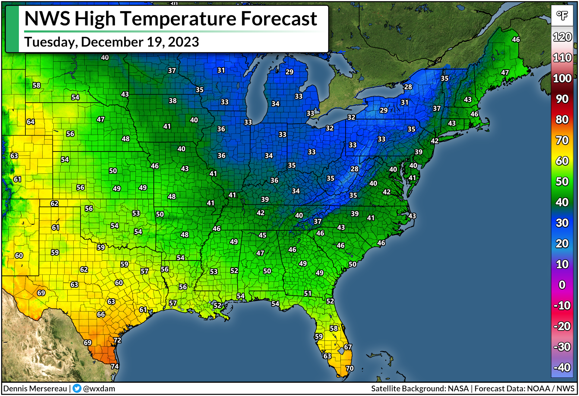
This is an...unusual...storm in that we're not really expecting any snow—at least not initially. Temperatures are too warm for anyone on the East Coast to see frozen precipitation as the storm swings through the region. It is the middle of December. That isn't normal. (But nothing really is anymore.)

Cold air wrapping in behind the system will allow for lake-effect snow to develop across the Great Lakes, so a dose of snow in the usual areas is likely to begin the week. This cold air will reach all the way to the coast in northwest flow behind the storm, making for a pretty chilly Tuesday before temperatures turn mild again as the week wears on.

[Top image via Tropical Tidbits, showing modeled surface winds on Sunday evening.]


Follow me on Facebook | Bluesky | Threads | Instagram | Twitter

Get in touch! Send me an email.

Please consider subscribing to my Patreon. Your support helps me write engaging, hype-free weather coverage—no fretting over ad revenue, no chasing viral clicks. Just the weather.


December 9, 2023

East Coast in for a pressure washing as a powerful storm arrives Sunday


A feisty low-pressure system is gearing up to bring plenty of disruptive weather to the East Coast over the next couple of days. Widespread heavy rain could lead to flooding along the I-95 megalopolis while the storm produces snow near the Great Lakes and severe storms across the southeast.

Sunday/Monday's storm is part of a dynamic pattern that's gradually making its way across the eastern half of the country. A cold front extending off a low-pressure system moving through the Great Lakes is responsible for most of the active weather we're seeing on Saturday. A new storm will develop along this front on Sunday, becoming the dominant system that'll bring all the headaches to end the weekend.


Sharp wind shear through the atmosphere combined with a cold front running into a pool of warm, moist air is a recipe for severe thunderstorms. An expansive severe risk covers a chunk of the southern U.S. on Saturday, mainly focused on the lower Mississippi Valley east into Alabama and Tennessee.

Any severe thunderstorms that bubble up on Saturday could produce damaging winds, hail, and a few tornadoes. We already saw a couple of tornadoes touch down in north-central Tennessee early Saturday afternoon.


We'll see that storm threat shift east on Sunday as the cold front heads toward the Atlantic coast. Severe thunderstorms are possible from the D.C./Baltimore region down the I-95/I-85 corridor toward southeastern Alabama and the northern half of Florida. The main risk with Sunday's storms would be damaging wind gusts, but a few tornadoes are possible, especially in parts of eastern Virginia and North Carolina.

Farther north, this developing storm's main threats will be drenching rains, heavy snow, and blustery conditions.

Flood watches span the I-95 corridor from D.C. to Portland as forecasters anticipate several inches of rain falling through the day Sunday. Lots of rain falling in short order can overwhelm waterways and drainage systems, leading to pooling and possible street flooding.


It's not going to be a gentle downpour, either. Widespread wind gusts of 20-30+ mph will accompany the storm as it chugs through interior New England on Sunday. Much stronger winds are likely for coastal communities across the northeast, where a period of 50-60+ mph wind gusts will be possible into Monday.

Winds this strong combined with wet soils could lead to fallen trees and power lines. Make sure your holiday decorations are tied down or brought inside, as well. Those things will take flight in a hurry once the gusty winds start, and it could be dangerous if they blow into the road.

Cold air flooding in behind the system will allow for widespread snow across the Northeast interior and down the spine of the Appalachians. The heaviest totals are likely near the Canadian border, where higher elevations in New York and Vermont could see more than a foot of fresh snow by Monday.


If you have plans to travel late Sunday or early Monday, it's worth keeping in mind that some models are struggling a bit with the potential changeover from rain to snow across parts of Pennsylvania, the Mid-Atlantic, and even down into the North Carolina Piedmont.

Plan ahead for the potential for a burst of snow during the last few hours of precipitation overnight Sunday into Monday, with possible accumulation if temperatures are cold enough.

[Top model image generated using WSV3]


Follow me on Facebook | Bluesky | Threads | Instagram | Twitter

Get in touch! Send me an email.

Please consider subscribing to my Patreon. Your support helps me write engaging, hype-free weather coverage—no fretting over ad revenue, no chasing viral clicks. Just the weather.