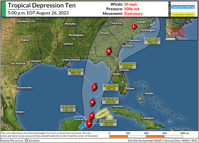
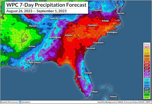
A newly formed tropical depression entering the southern Gulf of Mexico could strengthen in a hurry as it heads toward Florida over the next couple of days.
The National Hurricane Center declared a well-organized disturbance near the Yucatan Peninsula as Tropical Depression Ten on Saturday afternoon.
Dynamics are favorable for this system to get its act together in a hurry. As it is, the storm is almost as impressive as Hurricane Franklin on visible satellite imagery—though initial looks are deceiving when it comes to a storm like this.
 |
| Source: NOAA |
Our tropical depression is still building its internal structure, and the NHC expects the system to encounter a favorable environment to organize and strengthen as it enters the eastern Gulf over the next few days.
Wind shear across the region will slacken over the next few days, and bath-like ocean temperatures in the Gulf of Mexico will easily fuel the storm's development if the storm's structure is able to live up to its full potential.
Forecasters aren't holding back on the tropical depression's potential through early next week. The storm, which will earn the name Idalia, could become a hurricane as it approaches western Florida on Monday and Tuesday.
Landfall is most likely somewhere along Florida's Big Bend, but the system is meandering off the Yucatan Peninsula right now, and small changes in the storm's location and path will have large ramifications on where it makes landfall. Anyone in the Florida Panhandle or the state's west coast should closely monitor this storm's progress.
The storm's effects won't remain right along the coast, either. Drenching rains are possible well inland as the storm pushes into the southeastern states, bringing the potential for flash flooding as we head into next week. Downed trees, power outages, and isolated tornadoes are possible along the path of the storm once it makes landfall.
It's likely that the storm's intensity and predicted path will shift over the next couple of days. Remember that the storm forecast maps only apply to the center of the storm—hazardous winds and rain will extend hundreds of miles from the center of the storm.
Watches and warnings will likely be issued for the coast by Sunday or Monday. The NHC issues forecasts every six hours until alerts are issued, at which point forecasters will start issuing updates every three hours.


0 comments: