There’s an Enhanced Risk for Strong Tornadoes in the Mid-South on Saturday
An enhanced risk for severe thunderstorms exists in parts of the southeastern United States on Saturday, the third weekend in a row residents have to look out for an outbreak of dangerous thunderstorms. Today’s risk includes the possibility for strong, long-track tornadoes, as well as the chance for damaging wind gusts and large hail.
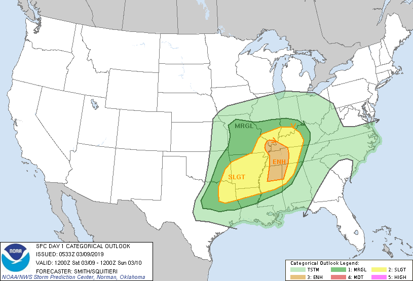
The overnight update from the Storm Prediction Center shows an enhanced risk for severe thunderstorms stretching across the eastern Mississippi Valley from about Cairo, Illinois, down to northeastern Mississippi. The enhanced risk includes eastern Memphis and western Memphis. It’s important not to focus solely on the bullseye in the forecast. Dangerous thunderstorms are possible across a large portion of the southern United States, stretching from Dallas/Fort Worth east through Birmingham and north through St. Louis and Louisville.
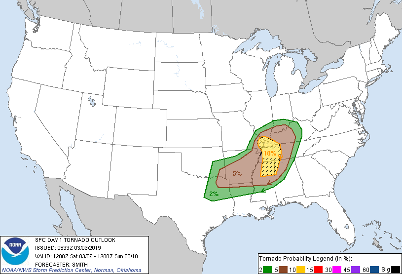
The enhanced risk is in effect because of the heightened risk for strong, long-lived tornadoes. If this sounds familiar, we went through this last weekend in Alabama/Georgia and the weekend before that over pretty much the same areas as today. That’s not to say that Saturday will be a repeat of either of those events. But all of the ingredients exist for thunderstorms to begin rotating and possibly produce significant tornadoes, in addition to large hail and damaging winds.
The SPC’s overnight update characterized this as a “complex forecast scenario” given all the moving parts in the atmosphere that could lead to (or hamper the development of) destructive thunderstorms during the day on Saturday. Stable air from morning showers/thunderstorms could rob certain areas of the instability storms need to thrive. Storms could also develop into squall lines and become predominately a straight-line wind threat. The greatest tornado risk will exist in discrete thunderstorms that develop independent of other lines or clusters, allowing them to fully engage with the instability and wind shear around them. The risk areas on the maps above will evolve through the day as forecasters get a better feel for the environment.
If you’re in or near the affected areas, make sure you have a way to receive weather warnings the moment they’re issued—most importantly, make sure wireless emergency alerts are activated on your phone—and ensure you have a plan in case you go under a warning. Avoid mobile homes and big box stores on a day like this. Put on closed-toe shoes if dangerous storms approach and keep a bicycle or motorcycle helmet in your safe place at home that you can put on if you need to take cover for a tornado warning.
(Apologies for snagging maps straight from the SPC rather than making them myself like I usually do. It’s late and my mapping program is giving me a hard time.)
Please consider subscribing to my Patreon. Reader-funded news is more important than ever and your support helps fund engaging, hype-free weather coverage.

