September 30, 2023

'We had no warning'—NYC flash floods test our strained attention economy


'We had no warning' is one of the most worrying and upsetting things anyone in the weather field can hear in the aftermath of an impactful storm. The latest wave of flash flooding that swamped much of New York City brought up the endless argument between 'we had no warning' and 'there was plenty of warning.'

The forecasts and warnings leading up to the storm were solid, with the risk for serious flash flooding in New York City appearing in forecasts well before the first downpours. But even so, the deluge seemed to arrive by surprise for countless folks across the city who voiced their displeasure over the apparent atmospheric broadside.

For years, folks in the weather field have personally shouldered the enormity of this problem. "It's our fault if people aren't getting the warnings," the conventional wisdom goes.

I'm not convinced anymore that it's entirely a problem on the communicators' side.

An overlooked issue seems to be that weather is taking up less space than ever in the attention economy. Warnings seem to be falling through the cracks because more folks are simply tuning them out—and I'm not sure that's something anyone can fix. 

NYC encounters another historic downpour

New York City has suffered plenty of historic rainstorms in the past couple of years, but the deluge on on Friday, September 29, will go down in history as one of the city's worst on record.

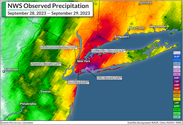
Much of the densely populated metro area saw 5-8+ inches of rain in short order between Thursday and Friday. The onslaught of water quickly overwhelmed the network of storm sewers that funnel runoff away from the concrete jungle. cascades of water pouring through the streets, into basements, and into the tunnels of the city's vaunted subway network.


It was a well-predicted disaster. Meteorologists pointed out the potential for torrential rains several days in advance, and local forecasters communicated the risk or flash flooding long before the first rain started falling.

The Weather Prediction Center issued a moderate risk for flash flooding across the NYC metro area by the middle of Thursday afternoon, and flood watches and flash flood warnings were hoisted with plenty of lead time to reach people in harm's way.


JFK Airport recorded a total of 8.58 inches of rain during the ordeal, 7.97 inches of which fell on September 29th alone, making for the airport's wettest day since records began back in 1948. 

Unfortunately, there's a vast gulf between issuing great forecasts and those excellent lead times actually reaching people in harm's way.

Warnings only matter if they're heard

A quick scroll through social media shows how much folks in the region were taken by surprise once the waters started rising. 'We had no warning' was a common complaint, as was criticism of the city's own preparation for the widespread flooding issues.

The uproar was amplified after New York's mayor bluntly criticized his own critics in a radio interview, saying "if anyone was caught off guard, they had to be living under a rock."

It's admittedly tough for meteorologists to put out warning after warning—and for officials to put emergency preparations in place—only to catch flack after the storm from folks who never heard about the threat for imminent danger.


After all, what good is a warning if the people who need it don't hear it?

Meteorologists always strive to improve forecast and warning lead times, trying their best to communicate hazards as far in advance as science and confidence will allow. This week's deluge likely would've taken folks by near-complete surprise not long ago.

Forecasters and news outlets always need to improve communication efforts. But it's a tough process. Experimenting with language as simple as the difference between "warning" vs. "emergency" is a yearslong social science project. (Take a look at NWS HazSimp if you want an inside look at how tweaking basic terms is a major effort.)

But meteorologists and emergency managers and bloggers and politicians can only do so much. The best forecasts and loudest warnings are only good if they reach the people who need them.

Our attention is stretched dangerously thin

The concept of an "attention economy" is real. We only have so much attention to give, and every aspect of our lives is competing for a piece of that finite mental real estate.

Our forms of entertainment are much different today than they were just ten years ago. Emergency alerts on television and radio reach far fewer people now that the vast majority of folks use streaming apps for shows and music.  

Apps make our phones chirp at us non-stop. It's easy to miss a flash flood warning in between breaking news alerts, advertisements, friend requests, texts, emails, and endless push alerts from games and sports apps and shopping and on and on. That doesn't even begin to cover wireless emergency alerts, which folks often disable after one too many ill-timed tests or Amber Alerts.

And then there are weather apps. We've all got apps on our phone that give us a high, a low, a chance of rain, and a cute icon with the day's weather conditions. Unless you've got a really, really good app, though, you're missing context. Words matter. Nuance is important. But they require more attention than a simple number or icon.

Most of those apps will tell you the chance of rain is 100%. For the most part, those same apps won't fill you in on the potential for excessive rainfall that could lead to widespread street flooding. We're giving up nuance in the never-ending quest to ration our well-worn attention.

So I'll give you the answer that most meteorologists, emergency managers, news organizations, and responders either can't or won't give: Each of us is ultimately responsible for our own safety. Much as folks don't want to admit it, a huge part of emergency preparedness falls on each one of us simply staying aware of what's going on every day.

The potential for flooding in and around New York City was well-advertised well in advance. Flash flood warnings went out with plenty of lead time.

People who routinely follow the weather knew that the past 48 hours would be rough across the region. 

People who don't, largely didn't.

Seeking out detailed weather information beyond a sleek icon and two numbers should be a normal part of everyone's daily routine. The weather is fine most days. Some days, though, it's not, and a few of those days will see dangerous conditions that could threaten your safety.

It can feel like a chore to have to read weather forecasts if you're not already interested in the day-to-day happenings in our skies above. But for all the humdrum updates on clear skies or gusty winds, there will be days where tornadoes are possible or a hurricane is on an unsteady course or 8 inches of rain could fall on the streets of New York City.

It's rare that a truly devastating weather event takes weather forecasters by surprise anymore.

It shouldn't take the rest of us by surprise anymore, either.

[Satellite image via NOAA]


Follow me on Facebook | Bluesky | Threads | Instagram | Twitter

Get in touch! Send me an email.

Please consider subscribing to my Patreon. Your support helps me write engaging, hype-free weather coverage—no fretting over ad revenue, no chasing viral clicks. Just the weather.


September 21, 2023

Developing tropical system to drench N.C., Mid-Atlantic with soaking rains


A system brewing in the southwestern Atlantic Ocean will bring heavy rain and gusty winds to a big chunk of North Carolina and the Mid-Atlantic states beginning Friday and lasting through the weekend.

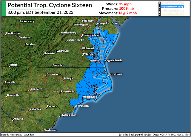
Localized flooding is possible in areas that see the heaviest rainfall totals, while some areas may deal with power outages as gusts exceed 45 mph in spots. Storm surge flooding is also likely along the coasts of North Carolina and Virginia, which will inundate roads and low-lying communities close to the shore.

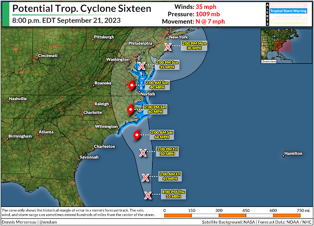
An area of disturbed weather just off the southeast coast is likely going to develop into a short-lived tropical storm over the next couple of days.


The National Hurricane Center dubbed the system "Potential Tropical Cyclone Sixteen," a purely bureaucratic title that allows them to issue tropical storm watches and warnings when a disturbance is close to land, but hasn't developed into an actual tropical system yet.

This disturbance will likely become Tropical Storm Ophelia by Friday night as it approaches a Saturday morning landfall in eastern North Carolina. It'll continue moving north through the weekend, losing organization as quickly as it developed, but still producing rainy and breezy conditions as it scoots north along the coast.


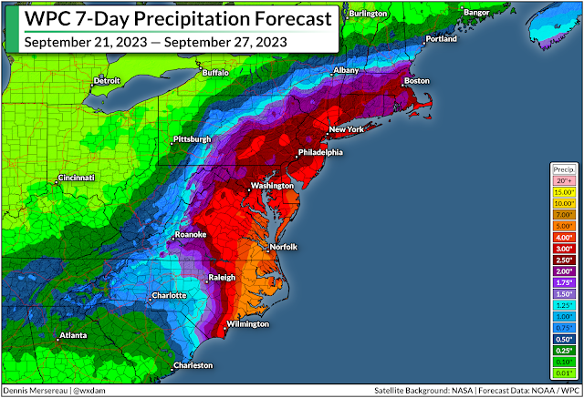
Regardless of its title or development, we're in for a solid stretch of soaking rains and gusty winds for much of the eastern seaboard between South Carolina and Massachusetts. The latest forecast from the Weather Prediction Center paints 2-4 inches of rain from Myrtle Beach to Boston, with the potential for 5+ inches of rain over eastern North Carolina and southeastern Virginia.

The combination of rain-soaked soil and gusty winds could lead to power outages in some areas.

Source: National Hurricane Center

We're also on the lookout for a not-insignificant storm surge for the North Carolina and Virginia coasts. The latest NHC forecast calls for the potential for 2-4 feet of storm surge along the Outer Banks if the surge coincides with high tide. That's more than enough to inundate coastal roads and potentially flood nearby communities.


Follow me on Facebook | Bluesky | Threads | Instagram | Twitter

Get in touch! Send me an email.

Please consider subscribing to my Patreon. Your support helps me write engaging, hype-free weather coverage—no fretting over ad revenue, no chasing viral clicks. Just the weather.


September 14, 2023

Tropical storm warnings up for New England as Lee approaches this weekend


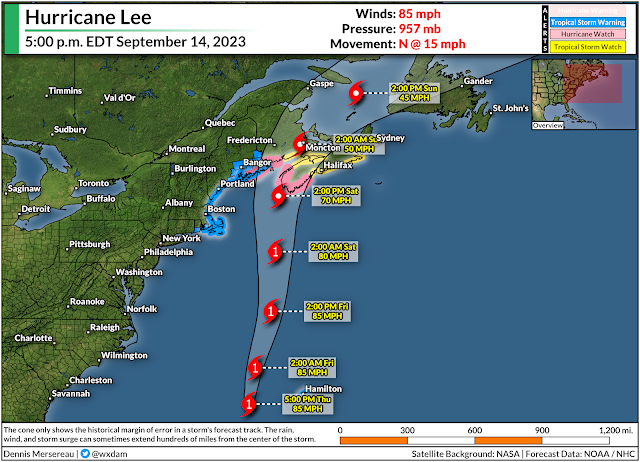
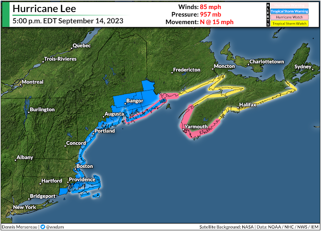
A tropical storm warning is in effect for much of coastal New England as Hurricane Lee continues to grow and pick up speed on its final approach to the region.

High winds, heavy rain, and coastal flooding are all likely as the storm pushes into the region. This isn't going to be a blockbuster storm by any means—more like a spicy nor'easter by the time it arrives—but that doesn't diminish the hazards posed by its high winds, heavy rains, and coastal flooding.


Hurricane Lee has grown into quite the sprawling storm in its ripe old age, with tropical storm force winds extending more than 345 miles from the center of the storm. This will give the system a far reach as it begins its final approach toward New England and the Canadian Maritimes heading into this weekend.


The National Hurricane Center's latest forecast brings the storm's outer fringes into coastal New England and the Canadian Maritimes by Saturday morning, with conditions quickly deteriorating through the day as the center of the storm arrives. The system could make landfall on the southern tip of Nova Scotia by Saturday afternoon.

It's not going to stick around for long. Lee will slowly pick up speed as it heads north, so we're looking at the worst impacts stateside through the day Saturday, lingering into Sunday for portions of Atlantic Canada.

A tropical storm warning is in effect for coastal New England from Westport, Massachusetts north toward the Canadian border, including the cities of Boston, Portland, Bangor, as well as Nantucket, Martha's Vineyard, and Cape Cod.


These areas could see a period of sustained 40-50 mph winds through the day Saturday, with higher gusts possible. We routinely have winds that strong with wintertime nor'easters, but all the trees still have their leaves, so they'll endure more stress now than they would in a comparable storm in, say, January. This could lead to tree damage and power outages throughout the region, especially near the coast where the highest winds are likely.

Lee's immense size will also push water into the coast through a storm surge and dangerously rough surf. Forecasters expect a 1-3 foot storm surge along the coast from Martha's Vineyard north toward New Brunswick. This will lead to flooding in some communities along the coast, as well as the risk for road washouts and beach erosion.


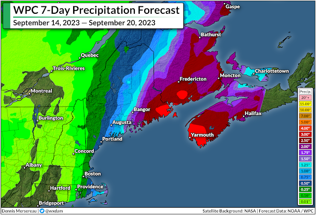
The storm will also arrive with plenty of tropical rain. Widespread rainfall totals of 1-2 inches are likely throughout coastal New England, with eastern Maine potentially picking up 3-4+ inches of rain by the end of the storm.

Flash flooding from heavy rainfall is the greatest threat with any tropical system, with drivers drowning in their vehicles accounting for most flood-related fatalities. Never try to drive across a flooded roadway. It's impossible to tell how deep the water is until it's too late, and the road may be washed out beneath the floodwaters. It only takes about six inches of water for a vehicle to lose traction.

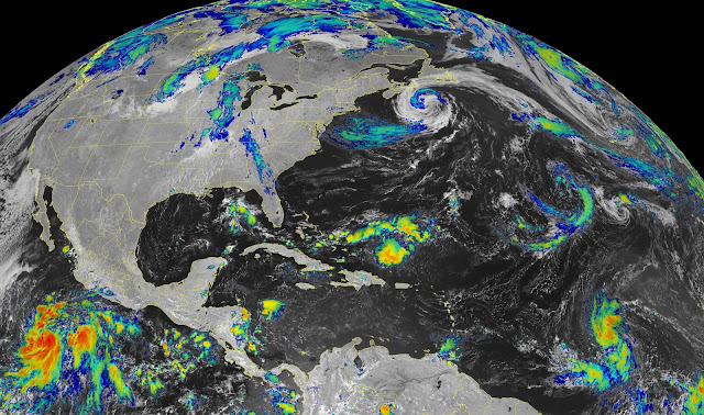
[Satellite image via NOAA]

Follow me on Facebook | Bluesky | Threads | Instagram | Twitter

Get in touch! Send me an email.

Please consider subscribing to my Patreon. Your support helps me write engaging, hype-free weather coverage—no fretting over ad revenue, no chasing viral clicks. Just the weather.


September 12, 2023

Lee still a large and powerful storm, New England impacts likely this weekend


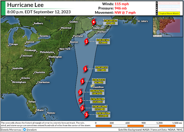
Hurricane Lee remains a large and powerful storm south of Bermuda this evening as it begins the final stage of its weeks-long journey across the Atlantic Ocean.

The window for a harmless turn out to sea is closing in a hurry, likely locking in a period of hazardous weather for New England and the Canadian Maritimes this weekend.


Heavy rains, high winds, and coastal flooding will accompany the storm as it affects the region through Saturday and Sunday. While the storm's precise track will determine where the greatest impacts unfold, Lee is a big storm and it'll continue growing through the week, giving it a large reach as it pushes inland this weekend.

Lee is big and getting bigger

Hurricane Lee intensified into a category five storm late last week, becoming only the 29th hurricane to achieve this scale-topping feat since the satellite era began back in 1960.

The brevity of the storm's peak was a testament to the fragile nature of these immense systems. A tiny bit of unexpected dry air and wind shear knocked Lee off balance not long after its peak, weakening its winds from 165 mph on Friday morning to 'just' 110 mph by Sunday morning.


A favorable environment in the southwestern Atlantic allowed the storm to recover, once again growing into a major hurricane south of Bermuda as it slowly begins marching north.

Hurricanes can use their energy in two ways. A storm can focus all its fury on a tiny section of the eyewall, or it can use that energy to expand its footprint and spread its winds over a very large area.

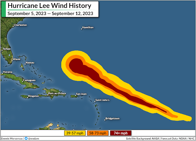
We can see Lee advancing in age by the way its wind field has grown since it first developed on September 5.

Lee is a very large hurricane now, with tropical storm force winds extending 240 miles away from the center of the storm. An uncrewed drone sailing into the storm measured a 92 mph wind gust 70 miles away from the center of the storm.

This wind field will continue to grow even as it weakens over the next few days as Lee pushes north toward New England and the Maritimes. Forecasters expect the storm to approach Maine and Nova Scotia at hurricane strength on Saturday.

New England and Canadian Maritimes are in the path

It's looking less likely with time that Lee will make a right-hand turn out to sea, essentially assuring foul conditions for parts of New England, New Brunswick, Nova Scotia, and Prince Edward Island for much of this weekend.

The greatest uncertainty seems to be exactly what Lee does when it approaches the region. Forecasters and models both generally agree that Lee will continue pushing north through the remainder of the week, all while a cold front closes in on the storm from the west.


Eventually, the upper-level trough bringing the cooler, drier air over the East Coast will flex its influence over Lee and force it to transition from a hurricane into a storm that more closely resembles a nor'easter.

If the storm tracks a bit to the west, it would bring gustier winds and heavier rainfall into more populous sections of New England. A path farther east would keep the worst weather over the Maritime provinces.

It's still four to five days out. Small changes in Lee's track now will have big implications for its path later on. The bottom line is that folks throughout New England should keep a close eye on the storm and prepare now for a potentially rough spell of weather this weekend.

Prepare now so you're not caught by surprise later

This isn't going to be a blockbuster storm like Fiona or Dorian for the Maritimes, nor will it be a monstrous hurricane for New England.

That said, coastal communities in Maine are in for a steady dose of heavy rain, gusty winds, and a likely period of coastal flooding from storm surge and rough surf.

The latest forecast from the Weather Prediction Center calls for 2-4 inches of rain for much of eastern Maine, with heavier totals possible if the storm jogs a bit farther west than currently forecast. This could lead to localized flooding in vulnerable areas and in spots with poor drainage.


Given the storm's growing footprint, gusty winds of 70+ mph seem likely along the coast, with decent gusts pushing farther inland depending on the storm's ultimate track. The trees are still fully dressed in their summer best right now, so they'll endure more stress than they would during a wintertime nor'easter.

Tree damage is likely in areas that see the strongest winds. Remain mindful of any trees or tree limbs that hang over your home. Trees falling into homes and vehicles is the leading cause of wind-related injury in a storm like this. Take the time to trim them if you can, and avoid rooms where trees may fall once the storm arrives. 

At least some power outages are a pretty sure bet with winds this strong. Look around and make sure you've got enough supplies to last at least a couple days without power if needed.

Non-perishable food that doesn't require cooking, water, personal hygiene supplies, and spare batteries are all a necessity.

Also—make sure you have actual flashlights! Your cell phone's flashlight is a waste of a precious charge when the power goes out. 


Follow me on Facebook | Bluesky | Threads | Instagram | Twitter

Get in touch! Send me an email.

Please consider subscribing to my Patreon. Your support helps me write engaging, hype-free weather coverage—no fretting over ad revenue, no chasing viral clicks. Just the weather.


September 5, 2023

Keep your guard up: A powerful Atlantic hurricane is a misinformation magnet


Tropical Storm Lee is gathering steam in a hurry as it swirls to life the heart of the tropical Atlantic Ocean, and the storm will have free rein to grow into a powerful hurricane over the next few days as it putters west across the open waters.

The prospect of a large category four hurricane entering the western Atlantic Ocean is frightening, especially after the hectic pace of destructive storms we've seen over the past seven years.

It's been a long while since we've had a weeks-long run-up to a major hurricane in the Atlantic. Many of our most powerful storms in recent seasons developed and made landfall in just a couple of days. It took only 70 hours for Idalia to grow from a newborn tropical storm to a major hurricane making landfall in Florida.


The long wait for a slow-growing storm to do something—anything—is a breeding ground for both the misinformed and the malicious to spread false information or downright lies about a system's potential impacts.

Predicting the future is messy—and there are limits to accuracy

Lee is a young system that's more than a week away from entering the western Atlantic Ocean. As of this post's publication, we don't know where it's ultimately going to go, or how strong it will be when it gets there.
Source: NOAA/NHC

"We don't know" is a powerful statement. Meteorology is a humbling field. Folks driven by their big egos don't make it very far without looking like total heels and losing respect in the process.

The science of meteorology has advanced by leaps and bounds in the tech age. A three-day and even five-day forecast today is lightyears more accurate than it was just 30 years ago.

Heck, the National Hurricane Center (NHC) keeps a record of its forecast track errors all the way back to the 1970s. Their forecast accuracy today is a thing of marvel compared to when music videos were must-see TV.

Look at this cone of uncertainty for Rita back in 2005:


The NHC's cone (a margin of error based on past forecast track errors) stretches from northern Mexico to northern Louisiana five days out—closing in on something like 1.5x to 2x the margin of error of today's five-day forecast.

But the science is still painfully reserved. There is a limit to how far out an accurate forecast can go even under the best circumstances.

Today, forecasters can tell you that it'll be 92°F tomorrow with a chance of thunderstorms. Seven days from now, it'll probably be in the mid-80s with a chance for showers or storms.

Forecasts over time shift from specifics to trends. You lose that precision because of the sheer number of variables that affect our day-to-day weather.

Tiny changes have a huge effect on a storm's strength and track

Think about the game Plinko on The Price Is Right. The slot you drop the puck in will have a dramatic outcome on which pocket the puck lands in. Every time the puck hits a peg, it gets shunted to the right or to the left. You can have a general idea where the puck will land, but you can't tell for sure until it's near the bottom of the board.

The weather works in a similar way—without the potential to win $10,000, I guess.

Tweaking tiny details within the atmosphere can have a tremendous impact on the outcome of a storm. Move a ridge or a trough by 100 miles. Make the water one degree cooler. Crank up or weaken the storm's winds by 20 mph. Put a little dry air in the storm's path.

Any one of those factors can and will determine the ultimate intensity and path of a storm, and even seemingly small details can snowball into a large effect after a few days.

Dozens upon dozens of weather models take those changes into account

The advent of deeply nerdy weather broadcasts and countless weather pages on social media added terms like "GFS model" and "European model" to the average news consumer's vocabulary.
Spaghetti plot. Source: Tropical Tidbits

The GFS and the Euro are two major global models that meteorologists use while they're forecasting, but the output generated by those two big names are only a piece of the overall puzzle. There are also other global models, as well as a whole arsenal of smaller-scale models and guidance built specifically to help with hurricane forecasting.

It's rare for all those models to agree with one another. Much like humans, each model has its own biases and weaknesses that could affect its output. That's why you'll see "spaghetti plots" during hurricane season.

These composite graphics take all the major models tracking the progress of a tropical system and plot the output as a line. All the lines together look like spaghetti plopped onto a map, providing a great overview of how the models agree or disagree.

But those major models only scratch the surface. Almost all the big weather models you hear about, like the GFS and the Euro, also run alongside dozens of ensemble models.

Ensemble models account for the Plinko effect of tiny changes within the atmosphere. Each ensemble model slightly tweaks atmospheric conditions like temperature, wind, and air pressure. Dozens of these ensembles put together show a range of possibilities based on different starting conditions—sort of like a margin of error. If there's a huge spread or disagreement in the ensemble run, it means there's greater uncertainty in the final outcome.

Source: Pivotal Weather

Here's a GFS Ensemble run for Tropical Storm Lee in the system's infancy on the afternoon of September 5, 2023. This image shows all the different ensemble runs showing where Lee's center could be in 24 hours, accounting for all those slight tweaks to the atmosphere.

Each two-digit pink number near the center of the low shows a different individual ensemble run, while the large L averages out all the positions together.

They're relatively close together, showing relatively good agreement on Tropical Storm Lee's short-term movement.

But then you advance the same model two days into the future, then three, and they start to diverge from one another. Each individual run has its own idea of where Lee might trek based on all those small changes to factors like steering winds and the location of nearby ridges and troughs.

SourcePivotal Weather

By the time you're out 168 hours, or seven full days, the ensemble members are all over the place. There's a 300-400 mile spread in the ensembles, showing that Lee could be anywhere from the Turks and Caicos Islands to closing in on Bermuda.

That may not seem like too big of a difference, but a small nudge in the storm's track can mean the difference between harmlessly swirling out to sea or coming close to densely populated areas.

Weather models are called "computer guidance" for a reason. Models are just some of the many tools that meteorologists use when they're predicting the weather. But notice how you hardly ever see those ensemble runs show up on social media outside of a meteorologist talking about them when they're nerding out with other meteorologists.

So when you're scrolling through TikTok at night and you see a video that says "Major hurricane hitting North Carolina in two weeks" plastered over a loop of a weather model running 384 hours (16 days!) into the future...you can bet they're just doing that for attention and clicks.

It's not a new phenomenon. I've been railing against weather weenies on Facebook and Twitter for more than a decade. They've just migrated to other platforms with time, largely opting for the video route on YouTube—where the scariest, boldest thumbnail gets the click and the view—or TikTok, where you have to capture someone's attention in a fraction of a second or they'll ignore you and scroll on.

The open-source nature of weather data and weather models is a double-edged sword. A wealth of free and accessible resources is perfect for a freelance weather reporter like me. But it also puts this powerful tool in the hands of folks who can prey on those who don't understand what they're looking at.

"We don't know" is strength, not stupidity

Uncertainty isn't sexy. "We don't know" doesn't sell. But that single model run that shows a major hurricane ramming ashore in 13 days will get the clicks and the views and the ad revenue, so bad actors run with it to get attention.

Nuance is a good thing. There's power in "we don't know." Discussing what we don't know is a sign of a mind at work rather than a lack of knowledge. Admitting uncertainty shows integrity. It's your fellow adults levelling with you as a peer who deserves the truth rather than talking down to you like a child who needs to hear a tall tale to feel better.

But uncertainty is also scary. It's truly frightening to know that there will likely be a textbook hurricane with an ominous eye barreling west across the ocean before long. We want to know where it's going. We want as much time as possible to prepare for potential danger—physically, mentally, and emotionally. 

Those bad actors who knowingly pump out false information in the long leadup to an impactful storm are preying on that fear. They know that a huge number of people faced between choosing "we don't know" or "look at this monster!" will choose the appearance of knowledge rather than the cold vacuum of uncertainty.

Seek out the experts and tune out the noise

That's why—these days more than ever—it's so important to analyze what you're reading and watching to make sure you're getting accurate information rather than bunk that's twisted to manipulate your fears and emotions.


Seek out actual forecasts from the National Hurricane Center. Read the forecast discussions put out by the NHC's experts every six hours. They go deep into the technical jargon, but much of it is accessible and gives you an inside look at their thought processes and uncertainty. They're the ultimate experts and they're not afraid to say "here's what we know, and here's what we don't know."

Read articles written by the big weather-focused outlets (full disclosure: in addition to this blog, I'm a part-time writer for The Weather Network) and smaller reputable sources like The Eyewall, headed up by Matt Lanza and Eric Berger, both of whom are revered by storm-smart folks throughout the Houston area and the weather industry at large.

Follow proven, knowledgeable folks on social media, keeping in mind that blue 'verification' badges are bought and paid for now and are no longer a sign of potential trustworthiness or news value.

Despite the site's painful downturn, Twitter is still full of experts who discuss current storms in a way that anyone can understand and appreciate—Jacob Feuerstein, Philip KlotzbachTomer Burg, Eric Webb, and Philippe Papin are just a few of the dozens of fantastic meteorologists who could add so much value to your Twitter feed to drown out the noise.

We have to be our own digital advocates. Your screens are full of people trying to take advantage of you, trying to prey on your fears, trying to entice you with the false allure of certainty and comfort where none may exist. They can't succeed.

[Top satellite image via NOAA]

Follow me on Facebook | Bluesky | Threads | Instagram | Twitter

Get in touch! Send me an email.

Please consider subscribing to my Patreon. Your support helps me write engaging, hype-free weather coverage—no fretting over ad revenue, no chasing viral clicks. Just the weather.


Tropical Storm Lee expected to grow into an intense hurricane this weekend


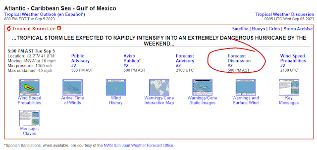
The National Hurricane Center (NHC) came out swinging on Tuesday when they issued their first advisory on what is now Tropical Storm Lee. The storm is moving into an extremely favorable environment for strengthening, and forecasters are confident that Lee will grow into a powerful hurricane in the days ahead.

Lee has been a formidable system since its early days as a disturbance rolling off western Africa. It's had 'that look' to it for several days now—persistent thunderstorms and an overall swirl that pretty much made its development a foregone conclusion.


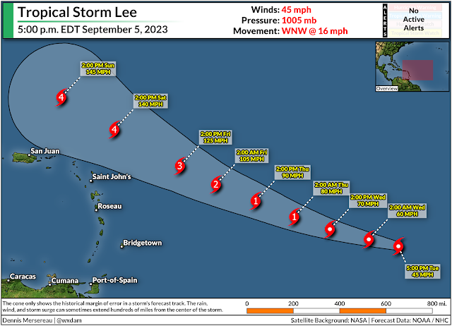
The system developed enough Tuesday to earn its status as tropical depression, quickly upgrading to a low-grade tropical storm with maximum sustained winds of 45 mph at 5:00 p.m. on Tuesday.

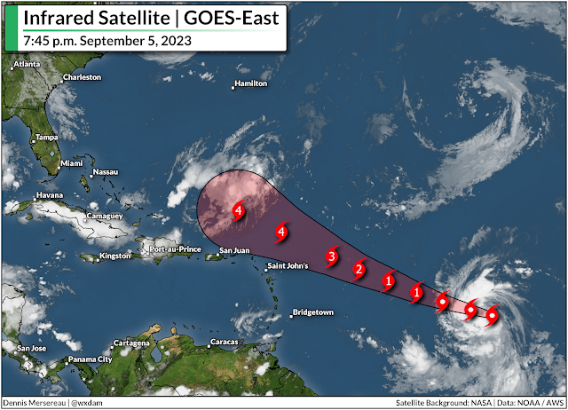
Conditions over the tropical Atlantic are very favorable for rapid development, especially for a system as healthy and well put-together as Lee. Forecasters expect Lee to steadily strengthen over the next five days, growing into a hurricane by Wednesday night and then into a major hurricane by the end of the week.


All indications point toward Lee becoming a very powerful hurricane by this weekend. The NHC's current forecast puts a strong category four hurricane north of the Lesser Antilles by Saturday. At this point, the only limit to Lee's strength may be how well it's able to organize its own internal structure.

It's very uncomfortable to see a powerful hurricane heading west across the Atlantic Ocean. It's also been a very long time since we've had a long-track Cape Verde-type hurricane like this.

Almost all of our big storms over the past couple of years developed relatively close to land. As best as I can tell, this is our first storm since 2019's Hurricane Dorian to have a 7-10+ day rollout from deep in the tropical Atlantic toward the western half of the ocean basin.

The extended, anxiety-filled watch-and-wait routine is tough in the social media era, especially with so many new hype-filled pages angling to fill the vacuum.

It is still too soon to say whether or not Lee will have any impacts on the United States late next week or beyond. Models are hinting at a potential recurve next week, but there are still too many variables and moving parts to make a call with any certainty. A slight difference in the placement of ridges and troughs will affect how these features tug and push on the storm, for instance.

Uncomfortable as it is, we really will have to watch and wait as the storm develops to see how it will interact with the environment and what its path could look like. We'll start to get a clearer idea toward the end of the week and this weekend.

Even if Lee winds up heading out to sea, it's best to prepare for a hurricane now so you're ready for whatever might come your way the rest of the season. The climatological peak of hurricane season is next week, and the tropics usually stay active through October and even into November.

Check your emergency supplies to make sure you've got enough non-perishable food, water, hygiene products, and batteries to last several days without power. Invest in a few battery packs to recharge your devices, and make sure you've got flashlights so you're not draining your cell phone battery using it to feel around in the dark. If you live in a flood-prone area, have evacuation plans ready long before you'd ever need them. Plan out alternate routes to work/school/stores in case of flooded roads.

We don't have to wait until a storm threatens to run through all these prep routines. It's good to have them in place so you have one less worry if anything ever does loom on the horizon.


Follow me on Facebook | Bluesky | Threads | Instagram | Twitter

Get in touch! Send me an email.

Please consider subscribing to my Patreon. Your support helps me write engaging, hype-free weather coverage—no fretting over ad revenue, no chasing viral clicks. Just the weather.