January 31, 2022

A High-Impact, Long-Duration Winter Storm Will Make A Gigantic Mess This Week


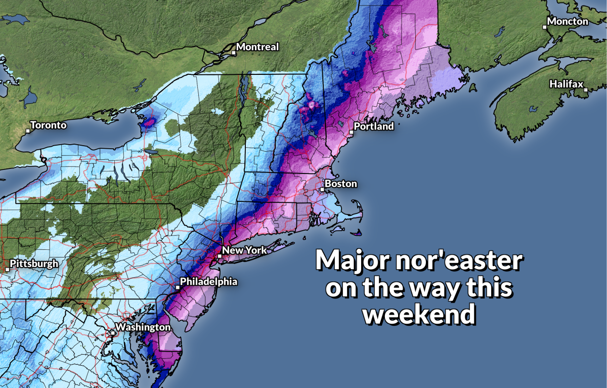
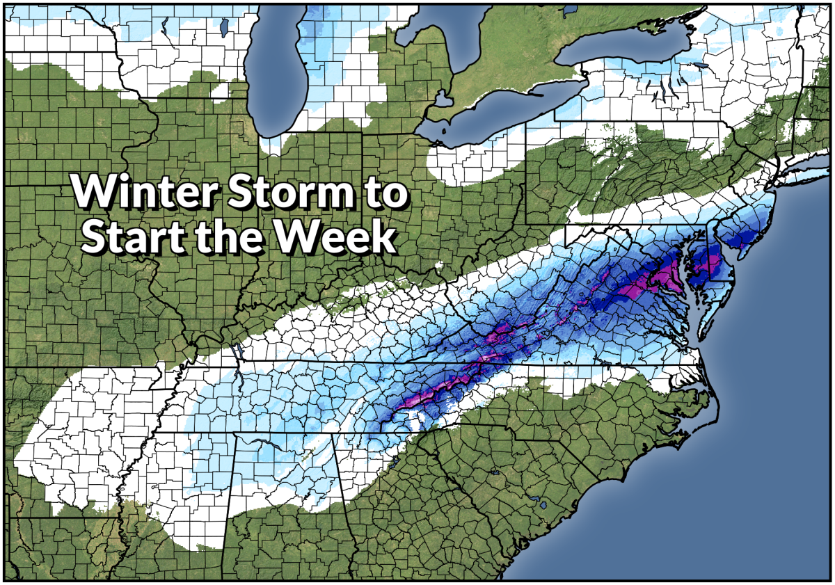
Fresh on the heels of a powerful nor'easter that brought blockbuster snows to New England is a new system that will affect an even wider swath of the United States. Snow, sleet, and freezing rain will develop across an enormous section of the country this week. This long-duration event could lead to continuous wintry precipitation for 24-36+ hours for some areas. Major travel and power disruptions are likely in the hardest-hit areas.

A Front Stalls And Causes A Huge Mess

First off, the term "winter storm" conjures up an image of a beautiful cinnamon bun-esque swirl gracefully plowing across the country. That's...not what this is going to look like. Here's the setup.

A large ridge of high pressure is building over the eastern United States at the same time that a trough digs down over the Canadian Prairies and northern Plains. We'll see plenty of active weather develop along the sharp contrast between the trough to the north and the ridge to the south.
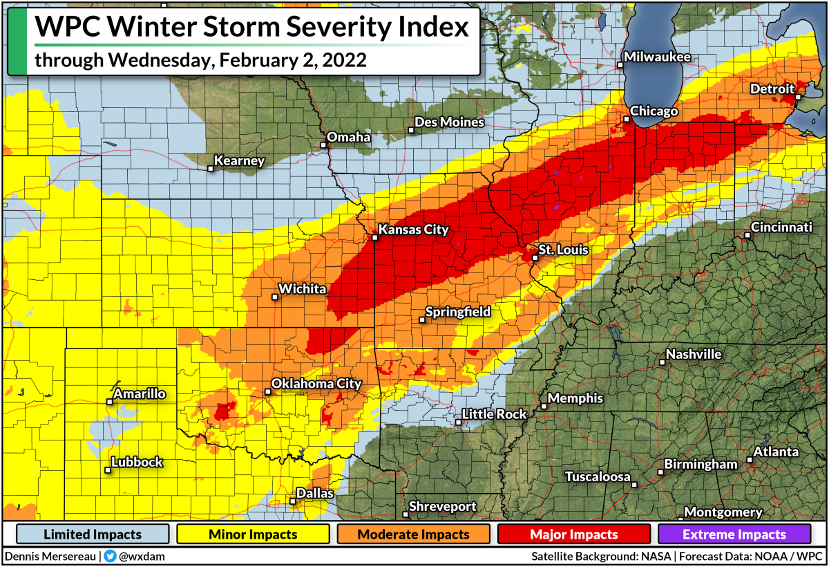
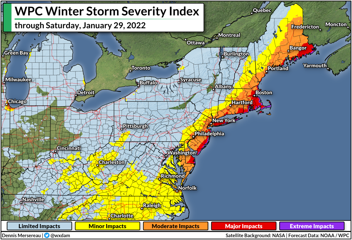
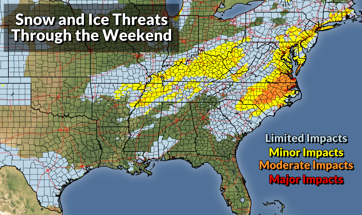
This map shows the WPC's Winter Storm Severity Index through Wednesday, February 2, 2022. Higher categories indicate a higher potential for disruptive snow and ice. 

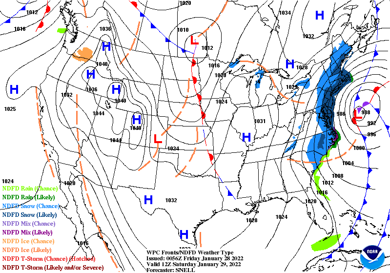
Down at the surface, we're looking at a center of low pressure scooting along the international border toward Ontario. The cold front stretching off this low will plow into the central U.S. by Tuesday night and then stall for the remainder of the week. Widespread lift along this front will lead to a slug of mixed precipitation extending from the Great Lakes south toward Texas.

We're going to see a huge zone under threat for snow, freezing rain, sleet, and regular ol' rain. The dividing lines between each precipitation type will be sharp and highly dependent on very subtle temperature differences a few thousand feet off the ground.

A Second Low Will Add Insult To Injury

At the same time the front stalls out, we'll see a low-pressure system starting to develop in Texas. This low will ride that frontal boundary up toward the Great Lakes on Wednesday into Thursday. This will bring a second round of mixed precipitation for roughly the same areas from Texas to the Northeast. We'll see the low track along the frontal boundary as it scoots toward New England through Saturday.
SOURCE: Tropical Tidbits

The one-two punch of precipitation along the front and precipitation from the low means there's a good chance that many areas will see 24-36+ continuous hours of snow or ice. That's...a problem!

The animation above shows what the event looks like on Monday morning's run of the GFS model. This won't play out exactly as the model shows, of course, but it does a good job illustrating the long-duration potential for snow and freezing rain.

This Is Shaping Up To Be A High-Impact Event

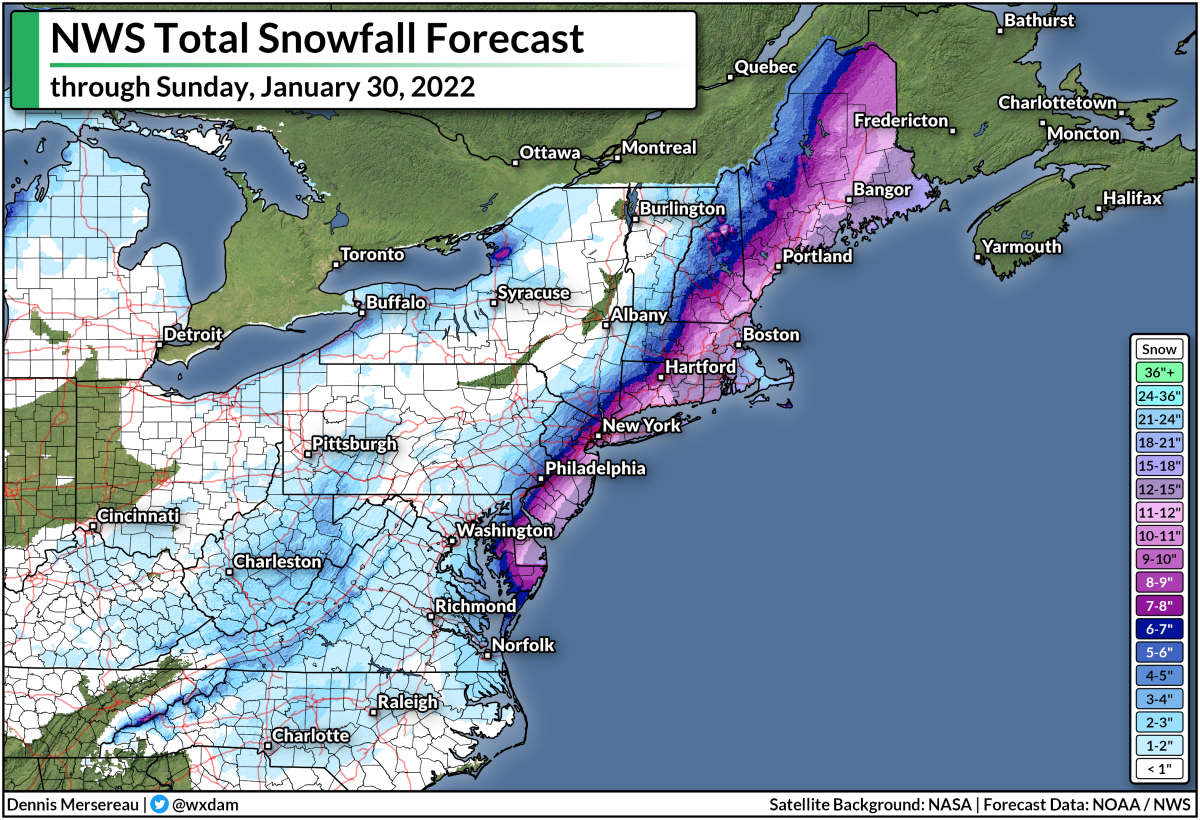
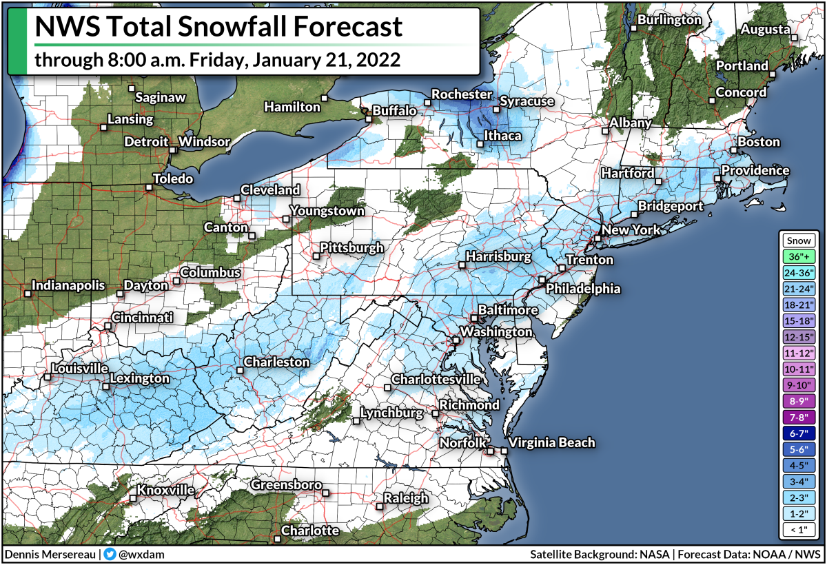
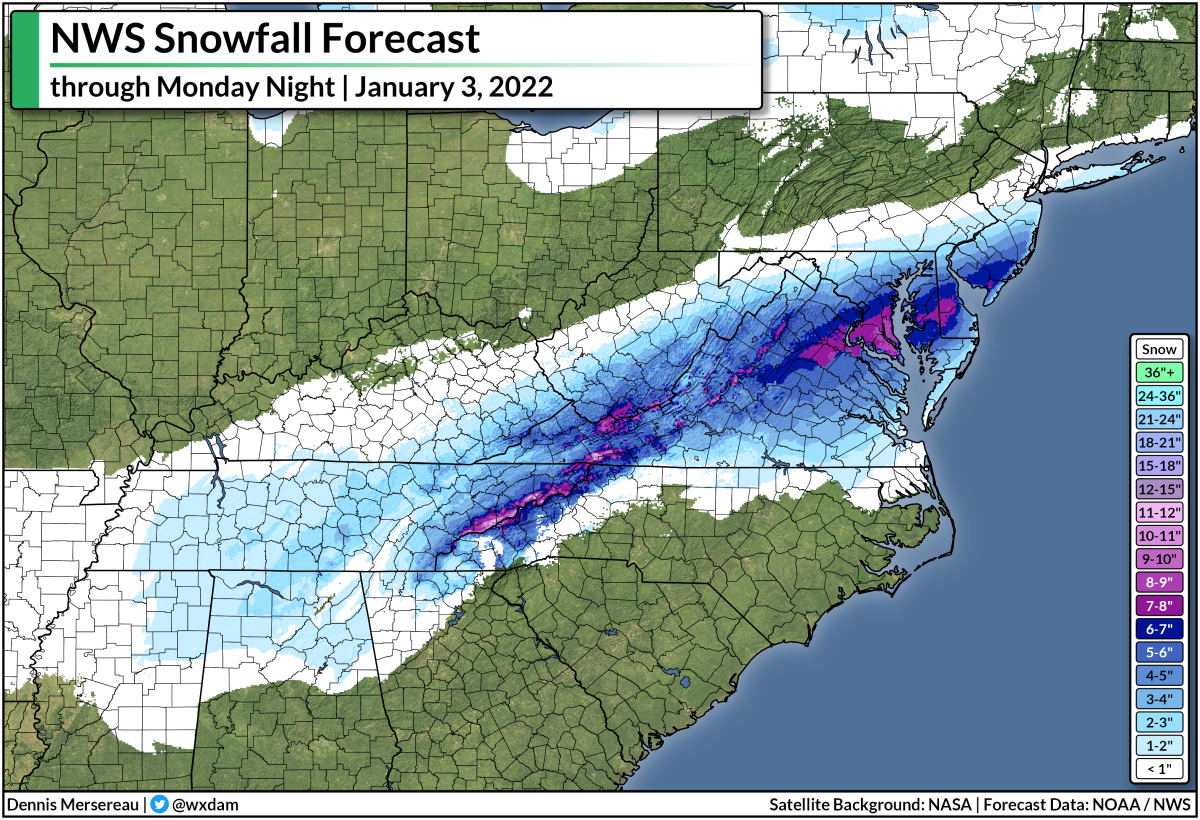
One issue with such a long-lasting event is that current snowfall and ice accretion forecasts don't cover the full extent of this event. Here's the National Weather Service's snowfall forecast through early Thursday morning:


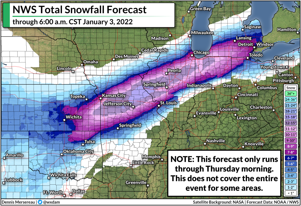
We'll still see heavy snow falling at the end of this forecast period, with the likelihood of snow stretching toward the Northeast into Saturday. This doesn't cover all of what may fall this week.

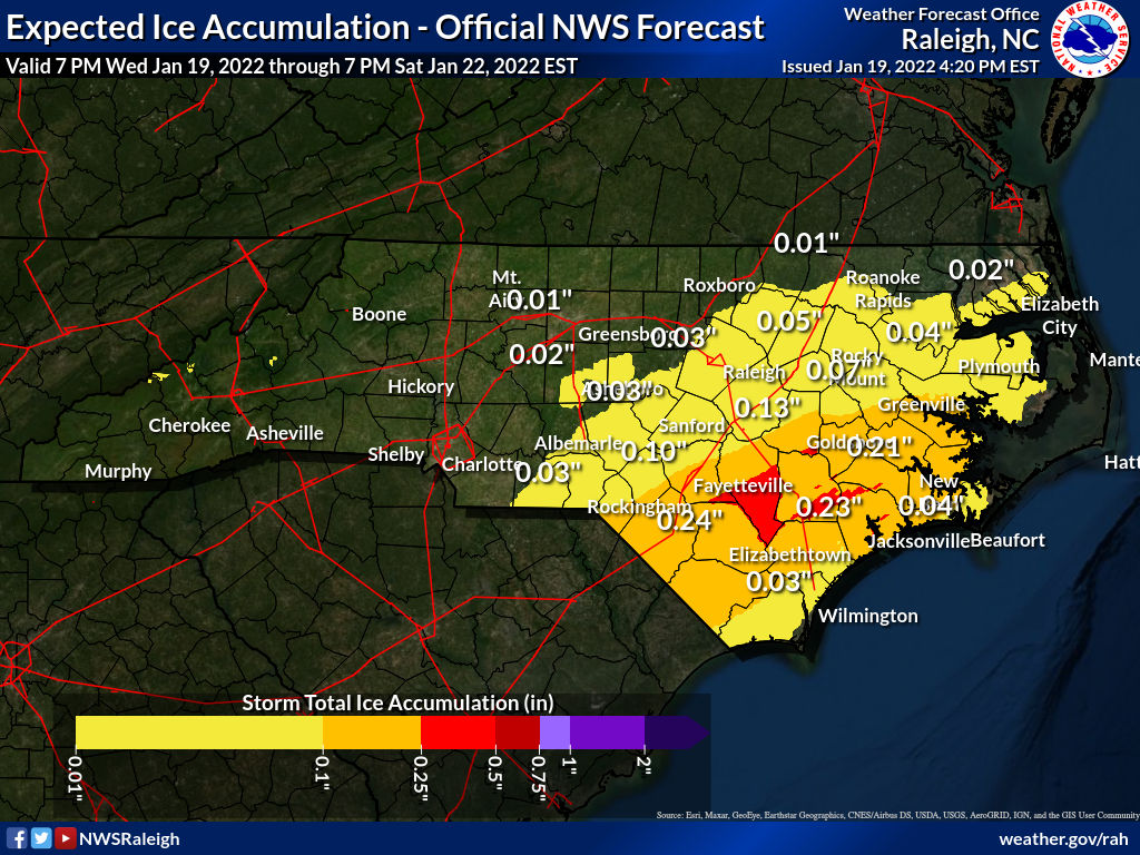
It's a similar situation with maps showing the potential for ice accretion from freezing rain. Below is the National Weather Service's ice accretion forecast, running through Thursday morning.
SOURCE: National Weather Service

Again, this doesn't show all of the freezing rain that may fall through the end of the week. These predicted totals will change as forecasters get a better idea of where the most freezing rain will fall.

Either way, we're on track to see an impactful ice storm for a very large area between the southern Plains and the Midwest, with the potential for disruptive ice even extending into parts of the Northeast. The geographic scope of the ice could stretch power crews to their limits, potentially leading to long-lived power outages for the hardest-hit communities.

On top of everything else, warm air and plenty of moisture on the southern side of that low will probably lead to a risk for flooding from heavy rain—and possibly a few severe thunderstorms—across the Deep South and the northern Gulf Coast toward the end of the week. 

It's Never Too Early To Prepare

It's safe to say that this will be a high-impact winter weather event that will snarl travel by road, rail, and air, and potentially lead to widespread power outages. If you live anywhere that could see significant winter weather this week, here's what you should do right now:

➤ Invest in a few rechargeable battery packs if you don't have any. They're cheap, reliable, and can extend your cell phone's battery long enough to carry you until the lights come back.

Gather up your flashlights and extra batteries, or get some from the store as soon as you can. You don't want to waste your cell phone's battery on light. A physical flashlight is an invaluable resource.

➤ Make sure you have ready-to-eat food like canned pasta and fruit cups so you don't have to struggle for food when the power is out. It's easy to forget how much food requires cooking until you can't cook.

➤ Prepare to alter any travel plans that could be affected by delays, cancellations, or road closures. You don't want to get stuck away from home when snow and ice are gumming everything up.

➤ If you can swing it, keep a few bucks on hand in case you need to buy something and can't use a debit or credit card. 

➤ Refill any prescriptions that need refilling soon so you don't run out if you can't get to the pharmacy or the power is out.

➤ Take some time to scout out any trees or tree limbs that loom large near your house. Trim them if you have the means to do so safely. Trees falling into homes are a significant source of injuries during ice storms (and windstorms, too). 

As always, keep up with the latest alerts from your local National Weather Service office. And don't overlook your local television meteorologists. Give them a follow on social media and pay attention to their posts. Systems like this are their bread and butter. They know their regions inside and out, and they all know the geographic quirks and local patterns that can really make their forecasts shine.


You can follow me on Twitter or send me an email.

Please consider subscribing to my Patreon. Your support helps me write engaging, hype-free weather coverage—no fretting over ad revenue, no chasing viral clicks. Just the weather.
 

January 27, 2022

A Powerful Nor'easter Will Bring Hefty Snows To Parts Of The Mid-Atlantic And Northeast


A powerful nor'easter will develop off the Mid-Atlantic coast on Friday night and race toward the Canadian Maritimes into this weekend. The track of the storm is extremely frustrating for meteorologists and residents alike—a tiny wobble to the west could bring major snowfall totals into big cities along I-95, while a small shift to the east could leave those cities with minor accumulations.

Winter storm watches and warnings are in effect from N.C.'s Outer Banks to the international border in Maine ahead of the impending system. The low-pressure system will develop off the North Carolina coast on Friday night, rapidly strengthening as it slides up the East Coast through the first half of Saturday.

Snow will begin over the Mid-Atlantic on Friday night as the system develops. A few inches of snow are possible into Virginia and North Carolina, with higher totals possible in the mountains.

For what it's worth, it only takes an inch or two of snow to make a serious mess of things in these areas. You get a little bit of snow on the roads when temperatures are hovering around freezing. Hot traffic drives over the fresh snow which compacts and melts it, leaving it to freeze into a sheet of ice that all the traffic behind slips and slides on. It only takes a little bit to make a big headache.

Anyway, the bulk of the storm is going to affect the coast overnight Friday through Saturday afternoon, and it's going to be such a close call for the big cities along Interstate 95.


The Weather Prediction Center's Winter Storm Severity Index (WSSI) does a good job telling the story of where the most impactful winter weather will take place. The red along the coast from the Delmarva Peninsula to the international border in Maine shows where communities will feel "major impacts" from steep snowfall totals and blowing snow from gusty winds.

If you look real close, you'll see a smattering of purples—"extreme impacts"—along the coast from Cape May, New Jersey, up through Eastport, Maine. This is where high winds will likely lead to blizzard or near-blizzard conditions for a time during the storm Friday night through Saturday morning.

It's looking increasingly likely that we'll see disruptive snowfall totals from southern Delaware up through Maine, with more than a foot possible in parts of Massachusetts and Rhode Island. Millions of people live right along the fine line between conversational snow and "big deal" snow.


Small shifts in the track of the system can lead to (seemingly) dramatic swings in forecast snowfall totals, as seen by the widely spread (and widely mocked) tweet from NBC News that said New York City could see between 2 and 20 inches of snow this weekend.
The Weather Prediction Center's forecast for 8:00 AM EST on Saturday, January 29, 2022. [NOAA/WPC]

Nor'easters really are systems where track is everything. Tiny shifts to the east or west can have huge implications when it comes to snowfall totals. Think about what a band of heavy snow looks like on radar—not only is it narrow to begin with, but the sharp edges of the heavy snow can mean two neighboring towns can experience two completely different outcomes.

There's a lot of frustration over the "well, we might get nothing, or we might get walloped," but really, that's just how it works with nor'easters. It sucks. It's frustrating. But that's how these storms go, especially when millions of people occupy a very slim swath of real estate near the coast. A shift of a dozen or two miles to the west could bury those towns, and a similar shift east could leave them without much to speak of. 


We're likely going to see significant snowfall totals across the Mid-Atlantic and Northeast. Thursday evening's forecast from local National Weather Service offices shows double-digit snowfall totals from the Delmarva to Maine, with parts of Rhode Island and eastern Massachusetts potentially scoring two feet of snow out of this system.

Just look at that western cutoff between a foot of snow and half that much. It wouldn't take much of a westward nudge in the storm's track to bring those hefty totals right into the megalopolis. That's why meteorologists have collectively tugged at their collars over this forecast. 

If you're in an area expecting heavy snow and high winds, it'd be a good idea to find (or get) flashlights and a few battery refills just in case your power goes out on Friday night or Saturday. You don't want to drain your cell phone battery on the flashlight feature. Also, remember to throw your phone on the charger before going to bed on Friday. It's also a good idea to have some rechargeable battery packs for your cell phone so you don't have to trudge out to the car for a recharge (or, worse, completely go without). 

Also, stay mindful of trees or tree limbs that might loom near portions of your home. Most injuries during windstorms occur when trees fall into homes. If you have a large or unstable tree near your house, try to avoid those rooms during the high winds whenever possible. Better safe than sorry and all that.


You can follow me on Twitter or send me an email.

Please consider subscribing to my Patreon. Your support helps me write engaging, hype-free weather coverage—no fretting over ad revenue, no chasing viral clicks. Just the weather.
 

January 19, 2022

More Rounds Of Snow And Ice Will Pelt Parts Of The South Through This Weekend


It's going to be a rough couple of days for folks from the Deep South to the I-95 corridor who can't stand winter weather. We could see disruptive wintry precipitation across a widespread portion of the southern and eastern states over the next couple of days, culminating with a potentially significant winter storm across the Carolinas heading into the weekend.

The threats cover three main areas:

➤  Snow across the I-95 corridor through the Thursday morning commute
➤  Icing in Texas and parts of the northern Gulf Coast Thursday night into Friday
➤  A significant winter storm in the Carolinas and Virginia Friday into Saturday

Except for the big Carolinas storm, we won't see big amounts, but it'll be just enough to snarl travel in each of the affected areas.

Burst of Snow Along I-95 Through Thursday Morning

A cold front moving toward the East Coast will bring some rain to the Mid-Atlantic and Northeast beginning Wednesday night and lasting into Thursday morning. Temperatures will rapidly fall behind the front, allowing much of the precipitation to change over to snow across the I-95 corridor.

We could see this changeover from the D.C. metro area up the interstate into Boston, potentially threatening a very tough morning commute for an area that struggles through a tough morning commute on sunny days. 


The National Weather Service expects only an inch or two of snow across the region, but that's plenty to cause serious headaches across the heavily urbanized I-95 corridor.


Light snowfall totals paired with hot traffic can melt the initial snow into a solid sheet of ice on roads, leaving behind a dangerous mess for the remainder of the commute. We've seen this plenty of times, especially in the D.C. area. 

Deep South Ice Threat Thursday Night Into Friday

Farther south, there's a threat for freezing rain and even a bit of sleet, especially across parts of southern and central Texas. Winter weather alerts are in effect for a big chunk of Texas that includes San Antonio, Austin, Corpus Christi, and Laredo. The alerts could stretch into the Houston metro area soon.

A cold front slouching through the Deep South on Thursday will leave behind plenty of cold air at the surface. While surface temperatures drop to or below freezing, things will be just a tiny bit warmer aloft, allowing precipitation behind the front to fall as a messy mix of freezing rain and sleet.

Source: NWS

The National Weather Service expects a light glaze of ice on Thursday night into Friday morning across a sizeable portion of Texas, with totals pushing one-tenth of an inch in many spots. That's not enough to cause widespread tree damage or power outages, but it'll be just enough to make the roads icy, potentially leading to widespread travel issues.

The potential for freezing rain also extends into the northern Gulf Coast, as well, with Baton Rouge, Biloxi, and maybe even Mobile getting in on the chance for a light glaze into Friday morning.

Significant Carolinas Winter Storm On Friday Into Saturday

The smattering of ice and snow will culminate in a significant winter storm across South Carolina, North Carolina, and Virginia beginning on Friday and stretching into the first half of Saturday.

As usual for storms in this part of the country, the northern end of the storm will feature a snow threat while the southern half of the storm is dominated by warmer air and the threat for freezing rain and sleet.

The threat for freezing rain looks particularly concerning across parts of eastern S.C. and N.C., where they can go years between remarkable ice storms. The National Weather Service predicts more than one-quarter of an inch of ice accretion from freezing rain in parts of northeastern S.C. and southeastern N.C., which would lead to widespread tree damage and power outages.

Here's a look at the NWS's ice forecast across South Carolina through Saturday morning:


And the agency's ice accretion outlook for North Carolina over the same period:


The abrupt changes across county/state lines are due to different NWS offices arriving at different forecasts for their areas of responsibility.

Farther north, snow is in the forecast and some communities could see a decent helping by the end of the storm on Saturday. A bullseye of 6+ inches of snow is possible across northeastern N.C. and parts of the Virginia tidewater, including Norfolk and Virginia Beach.


A couple of inches of snow is also possible farther west, especially around the Raleigh-Durham area and even stretching back into the Greensboro and Charlotte metros.

There is some uncertainty surrounding the westward/northward extent of the wintry precip, though, because of dry air potentially disrupting the system and the track of the low possibly stretching farther off the coast.


You can follow me on Twitter or send me an email.

Please consider subscribing to my Patreon. Your support helps me write engaging, hype-free weather coverage—no fretting over ad revenue, no chasing viral clicks. Just the weather.
 

January 13, 2022

Another Significant East Coast Winter Storm Is On The Way


We're staring down the potential for a significant winter storm across much of the East Coast this weekend. Hefty snowfall totals, significant ice from freezing rain, and gusty winds are all possible as the storm develops and races up the coast.

The Winter Storm Is In Its Infancy

Source: College of DuPage

A system sliding out of the Canadian Prairies will bring heavy snow to much of the Midwest through Friday as it dives toward the southeast. You can see the first pangs of the system's U.S. impacts with the snowfall spreading over the Dakotas tonight. Some folks in Iowa could end the day Friday with double-digit snowfall totals.

This system will swoop into the southeastern United States overnight into Saturday, developing into the winter storm we'll deal with along the East Coast this weekend. The system will rapidly get its act together as it starts moving parallel to the Appalachians, and that's where things get...interesting!

The storm around 8:00 a.m. on Sunday. (NOAA/WPC)

We'll see the greatest impacts in the southeast during the day on Sunday, moving into the Mid-Atlantic Sunday night into early Monday. The bulk of the wintry precipitation will move into the northeast on Monday before lifting away into eastern Canada overnight into Tuesday.

The storm around 8:00 a.m. on Monday. (NOAA/WPC)

Like many eastern winter storms, the precise track of this system will determine if some communities see a lot of rain, a lot of ice, or a lot of snow. This isn't going to be a straight snowstorm for many folks, especially not in the southeastern states. (Could you expect any more?) 

It's (Mostly) Too Early For The Fine Details

It's still too early for the maps I love to make using the National Weather Service's snowfall and ice accretion forecasts. Those forecasts only run out about 72 hours, which would take us to the early stages of the storm on Sunday evening.

The graphic at the top of this post shows the Weather Prediction Center's Winter Storm Severity Index (WSSI), a new-ish metric the agency uses to convey how impactful a winter storm will be for a certain area based on factors like snow totals, ice accumulations, blowing snow, and flash (sudden) freezes.

It looks like higher elevations in the Appalachians will see a solid snowstorm out of this event, with many areas picking up double-digit totals by the end of the storm. The Piedmont, on the other hand, is looking at a sloppy mess.

For many areas from northern Georgia into central Virginia, we're likely looking at snow changing over to sleet and/or freezing rain, then possibly back over to snow as the system departs on Sunday night.

Throw out all those fantastical weather models that showed something like 18" of snow in central North Carolina. Pfft. Chop that down to a tiny fraction once you account for sleet and freezing rain. This is going to be a mess, and any snow on the ground after the sleet and freezing rain is going to freeze hard into a solid mass of ice on Sunday night into Monday.

I can't not post any snowfall or ice graphics, of course, so here's what we have access to right now, courtesy of NWS Greenville, S.C.

This is their snowfall forecast as of Thursday evening:


And their ice accretion forecast from the same update:


The National Weather Service's forecasts for everyone else in the storm's path will go live through the day on Friday as the storm comes within range and forecasters get a better idea of who will see what. 

This is the type of scenario where weather apps on your phone and the pre-installed weather doohickey on your computer fails to give you the information you need. Getting the temperature and probability of precipitation only gives you a small part of the story.

Some forecasts are more complicated than just a few numbers and icons. You need context to get the full story about this weekend's winter storm, and you'll only get that context from articles like this and posts from (legit!) local meteorologists. This is where your local TV weatherperson comes in handy. Events like this are where their experience and local knowledge really shine.


You can follow me on Twitter or send me an email.

Please consider subscribing to my Patreon. Your support helps me write engaging, hype-free weather coverage—no fretting over ad revenue, no chasing viral clicks. Just the weather.
 

January 2, 2022

Mid-Atlantic Preparing For Decent Snowstorm, Sudden Freeze A Risk Monday Night


The season's first snowstorm is on its way for the Mid-Atlantic, and it could be the region's first formidable snowfall in a while for many areas. Some lucky folks could wind up with double-digit snowfall totals by the end of Monday. This is one of those rare events where snow seemed unlikely until just recently, so it could come as a surprise to folks who tuned out the weather this weekend.

A strong low-pressure system will rapidly develop and strengthen over the southeast late Sunday into early Monday. There's no shortage of moisture for the low to work with, so it's going to be a prolific rain- and snow-maker for much of the southeast and Mid-Atlantic.

Around these parts, cold air usually has to be here first before we can talk about accumulating snow. This is one of those setups where the Arctic air flooding in from the central U.S. will chase the low into the region. It appears likely that this upcoming storm will break the rule and cold air will arrive fast enough for hefty snowfall totals to fall from the Appalachians to the Atlantic. 

Winter storm warnings stretch from the Blue Ridge Mountains to the New Jersey shore ahead of the snow. Winter weather advisories are more expansive, with everyone from Memphis to Philadelphia getting in on at least a little bit of winter weather.


The map above looks a little janky, I know. This is a compilation of all the forecasts from local NWS offices as of 4:30 p.m. EST. Some of the offices update faster than others, and the snowfall amounts along office boundary borders don't always match up.

Still, you can get the general idea that the heaviest snow will fall over the southern Appalachians and through central Virginia, stretching toward the Delmarva and southern New Jersey. It's worth noting that the axis of heavy snow depends on the track of the storm, and it may wind up inching closer to the D.C. area.

Some areas could wind up notching double-digit snowfall totals before the storm ends on Monday afternoon. If it comes to fruition, this is going to be a decent storm for a region that hasn't seen many of them in recent years.

The sticky, wet snow—combined with gusty winds—could lead to power outages in some areas, so make sure you've got some flashlights, a fully charged cell phone, and some ready-to-eat food on hand in case the lights go out.


The snow will have trouble sticking to roads and sidewalks, especially in areas only expecting minor accumulations. The ground is warm. It's been unusually warm back east for the past couple of weeks. Highs on Saturday climbed into the 60s and 70s across the Mid-Atlantic and Carolinas.

Heavy snow rates will overcome warm ground temperatures and lead to snowy and slushy roads in areas expecting more than a couple of inches of snow.


We could see a sudden freeze behind the system as temperatures plunge Monday night into Tuesday. Low temperatures on Tuesday will push into the teens across Virginia and fall into the 20s from northern Mississippi into the Carolinas. 

Refreezing and black ice will become a huge problem come Tuesday morning, even in areas where snow didn't stick to paved surfaces. Any standing water left on the roads Monday night will freeze as the Arctic air settles over the area, making for dangerous travel conditions heading into Tuesday.

On the warmer side of the storm, several inches of heavy rain in a short period of time could lead to flooding issues. Flood watches are in effect for much of central and eastern North Carolina ahead of the rainfall Sunday night into Monday.

So...where did this storm come from?

Snowstorms don't often take us by surprise anymore. Models and forecasting methods are pretty good today, and it's more likely for a snowstorm to underperform than to kinda sneak up on us. Remember the storm of January 2000? That was a true surprise. What appeared to be nothing turned into a major winter storm that dropped a foot of snow over parts of the I-95 corridor. That was a complete whiff.

This one is sneaking up on us, sure, but we're still a day out from the biggest impacts. Folks have plenty of time to get ready and alter their plans with this storm...as long as they're paying attention and hear the winter storm alerts, that is. We're used to having days and days of advance notice, but a seemingly quick storm like this is a reminder that we should always pay attention to the forecast in case something dramatically changes.

Personally...I'm looking forward to the opportunity for even a little bit of snow. Not only has it been warm for the past couple of weeks, but many areas expecting snow through Monday haven't really seen much snow at all.

I live in Reidsville, N.C., which is just north of Greensboro. Our last significant snowfall was on December 9-10, 2018, when we got 16.5" of snow in the third-largest snowstorm ever recorded here.

Take a look at what we've seen since then:


Reidsville picks up about 7" of snow in a typical season. We saw 2.2" last winter, 1.6" the winter before that, and a blockbuster 16.5" of snow on December 9-10, 2018, which clocked in as our third-biggest snowstorm since records began in 1901. We got one big storm more than two years ago and we've had hardly anything since. Just pitiful. Hopefully we get a little more with this storm.


You can follow me on Twitter or send me an email.

Please consider subscribing to my Patreon. Your support helps me write engaging, hype-free weather coverage—no fretting over ad revenue, no chasing viral clicks. Just the weather.