January 3, 2025

Major winter storm set to snarl travel from Kansas City to Philly


Plenty of folks from Kansas to New Jersey are looking at their first winter storm of the season, which is slated to bring a significant swath of wintry precipitation from Kansas City to Philadelphia. Severe thunderstorms are possible on the southern side of the system.

The Setup

An upper-level trough rolling over the Rockies will spark the development of a low-pressure system over the Texas Panhandle on Saturday night. The low, drawing on moisture from the south, will develop in a hurry and bring a wide swath of wintry precipitation from the Midwest to the Mid-Atlantic.


This is going to be a formidable and memorable winter storm for some areas. Portions of the Midwest could see more than a foot of snow by the end of this system, while communities just south could see enough freezing rain to cause widespread power outages and tree damage.

We often talk about the track of a winter storm because a few miles to the north or the south could make a dramatic difference in whether communities get hammered by snow, coated in ice, or soaked in a cold rain.

This is a high-stakes forecast because so many major cities are right on the delicate line between snow, ice, and rain. The track of this storm will be key—if it tracks 20 miles north or south of where meteorologists currently expect, it would drag the swaths of heavy snow and freezing rain along with it. That's a bad prospect when so many big cities are perilously close to the lines between snow, ice, and rain.

Timing

The storm will begin developing over the central Plains by Saturday night. We'll see widespread snow and ice envelop Kansas and Missouri through the overnight hours, continuing into Sunday night around St. Louis. 

Snow and ice will spread across Illinois and Indiana through Sunday morning, continuing throughout the day and into the nighttime hours across the region. Expect significant icing across southern Illinois, southern Indiana, and much of Kentucky through Sunday and into Sunday night.


Precipitation will start crossing the Appalachians by Sunday evening, with snow beginning across D.C., Baltimore, and Philadelphia overnight into Monday. This is likely going to be an all-day event Monday.

On the southern side of the system, severe thunderstorms are likely to get going on Sunday afternoon and continue through the overnight hours into early Monday morning. Nocturnal severe thunderstorms are especially dangerous as people tune out the weather and head to bed. Make sure you have a way to receive warnings the moment they're issued if you're in the area.

Accumulations


As of Friday afternoon, the National Weather Service calls for a significant swath of heavy snow from central Kansas to southern New Jersey.

Kansas City, St. Louis, Indianapolis, Washington, and Baltimore all stand to see 6 or more inches of snow from this system. Some communities in northern Kansas and the northern half of Missouri could see more than 12 inches of snow through this weekend.

This much snow will be more than enough to make travel nearly impossible during the height of the storm. School, government, and business closures are almost certain on Monday and Tuesday, especially across the Mid-Atlantic.

Severe Thunderstorm Risk


Severe thunderstorms are a common risk during winter storms tracking across the middle of the country. Unstable air on the southern end of the low-pressure system will fuel thunderstorms across the Deep South. 

The main threat will be damaging straight-line winds as storms form along a cold front pushing from Texas to Alabama. Embedded tornadoes within that squall line can't be ruled out. 


Follow me on Facebook | Bluesky | Instagram

Get in touch! Send me an email.

Please consider subscribing to my Patreon. Your support helps me write engaging, hype-free weather coverage—no fretting over ad revenue, no chasing viral clicks. Just the weather.


March 22, 2024

Heavy snows, flooding rains likely as weekend coastal storm looms


An ugly weekend is shaping up along much of the East Coast as a potent low-pressure system rolls up the Atlantic seaboard.

Our developing system will feed on plenty of moisture streaming in from the south. This ample reserve of evaporated paradise will fuel heavy rains for much of the I-95 corridor, as well as bountiful snows across interior sections of New England.

This low-pressure system was already impressive in its infancy as it got its act together across the southeastern states on Friday.


Powerful thunderstorms rocked the southern tip of Florida, prompting tornado warnings and flash flood alerts across the Florida Keys.

There was even a remarkable long-lived supercell thunderstorm that tracked along the north-central shores of Cuba on Friday afternoon, dropping very large hail west and south of Havana.


We'll see this storm intensify as it rolls up the coast into Saturday, producing very heavy rains along its track. Expect widespread downpours to envelop the I-95 corridor from Richmond to Boston through the day Saturday, lingering into Saturday night for many areas.

Most communities will see several inches of rain in a relatively short period of time. Flash flood watches are in effect from Washington, D.C., up to Boston in anticipation of flooded roads and rising waters on vulnerable creeks.


Farther north, our moisture-laden storm will run into a slug of cold air that'll allow impressive snows to plaster towns from the New York's Tug Hill Plateau all the way through northern Maine. 

The National Weather Service expects more than a foot of snow to blanket the Adirondacks, much of Vermont, northern New Hampshire, and almost all of interior Maine west of I-95.

(Forecast graphic via NWS Caribou)

Things get tricky closer to the coast, where temperatures hovering around freezing will make for mixed precipitation types throughout the storm. Snow will give way to periods of freezing rain or plain ol' rain through Saturday night, then change back over to all snow on Sunday as cold air wraps around the departing system.

Folks around Augusta and Bangor may see an extended period of freezing rain during the switch on Saturday. Areas that see more than one-quarter of an inch of ice accretion may see tree damage and power outages.

The good news, at least, is that this storm isn't going to linger. This weekend's quick-hitting thump will give way to calm conditions and warming temperatures by the beginning of next week.

[Satellite image via NOAA]


Follow me on Facebook | Bluesky | Threads | Instagram | Twitter

Get in touch! Send me an email.

Please consider subscribing to my Patreon. Your support helps me write engaging, hype-free weather coverage—no fretting over ad revenue, no chasing viral clicks. Just the weather.


January 2, 2024

Uncertainty isn't a bad thing, and other info you need about the East Coast winter storm


A winter storm is possible across a wide chunk of the eastern U.S. this weekend as a strong storm developing in the southeast sweeps up the coast toward New England.

There's a great deal of uncertainty right now given that we're about four days away from the storm. Combine those lingering questions with the fact we haven't dealt with a winter storm here in almost two years (really!) and it's a recipe for confusion and viral misinformation.

Here's what you should know—and what we don't know—about the possible winter storm this weekend.

It's been a long time since the big cities have seen snow

A huge swath of the I-95 corridor has gone nearly two years without a significant snowfall.


New York's Central Park hasn't recorded at least one inch of snow in a single day since February 14, 2022, a historic streak of 688 days without enough snow to sweep or plow in a city that averages somewhere around 30 inches of snow in a typical winter.

This blew away Central Park's previous snow-free streak by something like double the old record, which is super impressive given their weather observations go all the way back to 1869.

It's the same sad tale farther down 95, where it's been about 700 days since we've seen an inch of snow in Philly, Baltimore, Washington, and even farther south toward Richmond and Greensboro.

We haven't had to deal with a true winter storm threat around these parts since early 2022. Many of these streaks may threaten to end by Saturday.

Necessary ingredients are coming together

You need to get lucky to have a decent winter storm along the eastern seaboard, especially if you're along the coast or south of Philly. The setup for an East Coast winter storm requires four basic ingredients:

  • A robust low-pressure system
  • Ample moisture across the storm
  • Ample cold air along the storm's track
  • The correct track to put you on the cold side of the storm
The failure of any of those factors can spell disaster for kids and kids at heart turning their pajamas inside out in the hopes of waking up to a blanket of frozen memories.

If the storm is weak, it could fizzle out. Lack of moisture could 'dry slot' you into very little to no precipitation. A battle of temperatures can lead to ice or boring rain.  And the precise track of any East Coast winter storm is make-or-break given the population density and unique geographic and atmospheric setup of the region.

"We don't know" reveals a mind at work

This storm is four days away. It's too soon to know specifics about who will get what, and how much of it you'll get.

Nuance and uncertainty aren't bad words, nor do they signal a lack of experience and expertise, nor are they hallmarks of laziness.

One of the major factors behind those hair-on-fire MASSIVE BLIZZARD COMING, LIKE AND SHARE! posts going viral on Facebook and Twitter and TikTok is that they fill the information void created by uncertainty. Fake confidence is more comforting than pondering the odds of different scenarios playing out.

Winter storms are particularly maddening because there are so many potential points of failure and it only takes a tiny shift in temperature or track to change snow to rain, rain to ice, or a promise of something shriveling up into a big ol' bust.

Forecasters along the East Coast from Atlanta to Bangor have to consider more than just the overall pattern when they're predicting a winter storm.

Terrain varies widely over short distances. Interstate 95 from Virginia to New York roughly runs along the fall line, the rapid elevation shift from the rolling hills of the Piedmont to the lowlands. Temperatures along the fall line often teeter around the freezing mark as cold continental air bucks against the ocean-warmed air to the east.
An example of cold air damming from November 2023.

This is why the tens of millions of people who live in cities dotting this major artery often struggle with the trickiest forecast. Will the storm bring rain, freezing rain, sleet, snow, or a shifting mix of all four?

That elevation change doesn't even factor in the cold air damming that often occurs along the Appalachian foothills, subjecting central Virginia—and central North Carolina in particular—to frequent threats for freezing rain and ice. 

Weather models aren't infallible

Weather models struggle with those issues, too. Meteorologists use computer guidance to craft their forecasts. No model is 100 percent correct. If you ever see someone posting raw snowfall totals from one weather model and passing it off as a forecast, it's an invitation to get your weather information somewhere else.
An animation showing weather model uncertainty over the course of a single day. (Tropical Tidbits)

These models all have their strengths and flaws, and it takes a knowledgeable forecaster to blend those strengths together and use their personal expertise to make a prediction.

The animation above shows raw output from the last five runs of the GFS model for 7:00 p.m. on Saturday, January 6. The model runs four times per day, so that's roughly a day's worth of GFS model prowess.

See how much the storm itself shifts around the Mid-Atlantic from one run to the next, not to mention how the precipitation types can wildly differ? That's the uncertainty! Confidence grows the closer we get to the storm, as models and forecasters both get a better handle on the situation and likely outcome. We're still four days out from the storm, which is why there's so much uncertainty.

This week's setup

The pattern we're in this week is very reminiscent of the classic El Niño wintertime pattern you'd see in a textbook or explainer article.

Winters during a strong El Niño tend to see a powerful subtropical jet stream snaking over the southern United States, which gives rise to frequent low-pressure systems that blossom over the Deep South before roaring up the eastern seaboard.
A snapshot of the GFS model on Tuesday morning, showing what the jet stream might look like on Saturday afternoon. (Tropical Tidbits)

Well...we've got that for sure. This type of a pattern is great for areas mired in drought, but it also provides a spark of hope for winter-weather lovers if those systems coincide with shoves of cold air diving down from Canada.

Winds will strengthen in the jet stream as a steep trough sweeps over the Rockies later this week, giving rise to a formidable low-pressure system over the northern Gulf of Mexico that'll likely track up the length of the eastern states heading into the weekend.

Those powerful winds in the jet stream will force air to rise in abundance, allowing a low-pressure system to develop over the northern Gulf Coast and begin roughly paralleling the Appalachians late Friday until it exits New England late Sunday.

We'll very likely have a weekend storm. (Check.)

That storm will have plenty of moisture to work with. (Check.)

Now, we've just got the cold air and the track of the storm to worry about. (Uh oh.)

The ultimate track of the storm makes all the difference

If the storm tracks a little too far west and a little too close to the mountains, it'll help drag milder air inland and keep communities along and east of I-95 rain for most or all of the storm.

A storm tracking just offshore puts this megalopolis in the perfect spot for cold air to arrive alongside the heaviest precipitation, which can lead to a decent blanket of snow.

A track right up the middle, though, leaves little margin for error—a few miles makes all the difference between precipitation types and amounts.
The likelihood of at least "minor" winter weather impacts between 7 a.m. Saturday and 7 p.m. Sunday, according to the Weather Prediction Center.

And right now, four days out from this storm, it's too soon to tell with confident precision where this storm will track.

Unfortunately, current trends seem to bring the storm up the middle of the Mid-Atlantic, threading that swampy needle between the Appalachians and the Atlantic in a way that brings huge changes over tiny distances.

Forecasters have high confidence that the Appalachians, much of Pennsylvania, and a swath of lower New England are in for shovelable snows late Friday night through Sunday evening as the system moves south to north. The bulk of the system would likely affect the most folks between Saturday morning and Sunday morning.

It looks like it'll be exceptionally close for the I-95 megalopolis, but the potential is there for D.C., Baltimore, Philly, and New York to end their yearslong snowless streaks. Farther south toward me in central North Carolina, cold air damming will likely rear its ugly head, making ice more likely than snow before the changeover to rain through the day Saturday.

This is a storm worth watching, as every news writer in the western hemisphere likes to say. It could prove disruptive to road and air travel over the weekend, especially from Pennsylvania northeast through Maine.

But there's still lots of uncertainty surrounding the precise details of this impending storm. We'll have clearer and more confident answers tomorrow, and sharper details still by Thursday. It's tempting to seek out the loudest voices promising all the answers. Hard as it is to find them these days, it's best to stick with the level-headed folks willing to level with you and say "we don't know yet."

[Top image showing colorful weather-models-as-art created using WSV3]


Follow me on Facebook | Bluesky | Threads | Instagram | Twitter

Get in touch! Send me an email.

Please consider subscribing to my Patreon. Your support helps me write engaging, hype-free weather coverage—no fretting over ad revenue, no chasing viral clicks. Just the weather.


January 31, 2022

A High-Impact, Long-Duration Winter Storm Will Make A Gigantic Mess This Week


Fresh on the heels of a powerful nor'easter that brought blockbuster snows to New England is a new system that will affect an even wider swath of the United States. Snow, sleet, and freezing rain will develop across an enormous section of the country this week. This long-duration event could lead to continuous wintry precipitation for 24-36+ hours for some areas. Major travel and power disruptions are likely in the hardest-hit areas.

A Front Stalls And Causes A Huge Mess

First off, the term "winter storm" conjures up an image of a beautiful cinnamon bun-esque swirl gracefully plowing across the country. That's...not what this is going to look like. Here's the setup.

A large ridge of high pressure is building over the eastern United States at the same time that a trough digs down over the Canadian Prairies and northern Plains. We'll see plenty of active weather develop along the sharp contrast between the trough to the north and the ridge to the south.
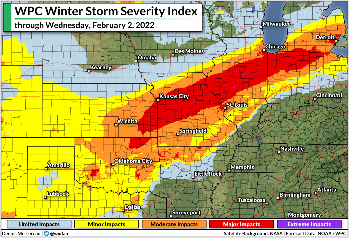
This map shows the WPC's Winter Storm Severity Index through Wednesday, February 2, 2022. Higher categories indicate a higher potential for disruptive snow and ice. 

Down at the surface, we're looking at a center of low pressure scooting along the international border toward Ontario. The cold front stretching off this low will plow into the central U.S. by Tuesday night and then stall for the remainder of the week. Widespread lift along this front will lead to a slug of mixed precipitation extending from the Great Lakes south toward Texas.

We're going to see a huge zone under threat for snow, freezing rain, sleet, and regular ol' rain. The dividing lines between each precipitation type will be sharp and highly dependent on very subtle temperature differences a few thousand feet off the ground.

A Second Low Will Add Insult To Injury

At the same time the front stalls out, we'll see a low-pressure system starting to develop in Texas. This low will ride that frontal boundary up toward the Great Lakes on Wednesday into Thursday. This will bring a second round of mixed precipitation for roughly the same areas from Texas to the Northeast. We'll see the low track along the frontal boundary as it scoots toward New England through Saturday.
SOURCE: Tropical Tidbits

The one-two punch of precipitation along the front and precipitation from the low means there's a good chance that many areas will see 24-36+ continuous hours of snow or ice. That's...a problem!

The animation above shows what the event looks like on Monday morning's run of the GFS model. This won't play out exactly as the model shows, of course, but it does a good job illustrating the long-duration potential for snow and freezing rain.

This Is Shaping Up To Be A High-Impact Event

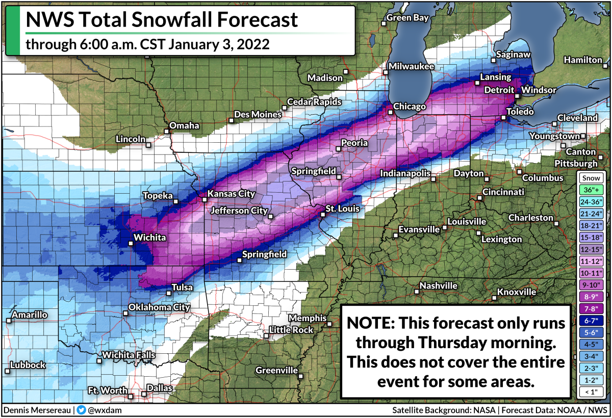
One issue with such a long-lasting event is that current snowfall and ice accretion forecasts don't cover the full extent of this event. Here's the National Weather Service's snowfall forecast through early Thursday morning:


We'll still see heavy snow falling at the end of this forecast period, with the likelihood of snow stretching toward the Northeast into Saturday. This doesn't cover all of what may fall this week.

It's a similar situation with maps showing the potential for ice accretion from freezing rain. Below is the National Weather Service's ice accretion forecast, running through Thursday morning.
SOURCE: National Weather Service

Again, this doesn't show all of the freezing rain that may fall through the end of the week. These predicted totals will change as forecasters get a better idea of where the most freezing rain will fall.

Either way, we're on track to see an impactful ice storm for a very large area between the southern Plains and the Midwest, with the potential for disruptive ice even extending into parts of the Northeast. The geographic scope of the ice could stretch power crews to their limits, potentially leading to long-lived power outages for the hardest-hit communities.

On top of everything else, warm air and plenty of moisture on the southern side of that low will probably lead to a risk for flooding from heavy rain—and possibly a few severe thunderstorms—across the Deep South and the northern Gulf Coast toward the end of the week. 

It's Never Too Early To Prepare

It's safe to say that this will be a high-impact winter weather event that will snarl travel by road, rail, and air, and potentially lead to widespread power outages. If you live anywhere that could see significant winter weather this week, here's what you should do right now:

➤ Invest in a few rechargeable battery packs if you don't have any. They're cheap, reliable, and can extend your cell phone's battery long enough to carry you until the lights come back.

Gather up your flashlights and extra batteries, or get some from the store as soon as you can. You don't want to waste your cell phone's battery on light. A physical flashlight is an invaluable resource.

➤ Make sure you have ready-to-eat food like canned pasta and fruit cups so you don't have to struggle for food when the power is out. It's easy to forget how much food requires cooking until you can't cook.

➤ Prepare to alter any travel plans that could be affected by delays, cancellations, or road closures. You don't want to get stuck away from home when snow and ice are gumming everything up.

➤ If you can swing it, keep a few bucks on hand in case you need to buy something and can't use a debit or credit card. 

➤ Refill any prescriptions that need refilling soon so you don't run out if you can't get to the pharmacy or the power is out.

➤ Take some time to scout out any trees or tree limbs that loom large near your house. Trim them if you have the means to do so safely. Trees falling into homes are a significant source of injuries during ice storms (and windstorms, too). 

As always, keep up with the latest alerts from your local National Weather Service office. And don't overlook your local television meteorologists. Give them a follow on social media and pay attention to their posts. Systems like this are their bread and butter. They know their regions inside and out, and they all know the geographic quirks and local patterns that can really make their forecasts shine.


You can follow me on Twitter or send me an email.

Please consider subscribing to my Patreon. Your support helps me write engaging, hype-free weather coverage—no fretting over ad revenue, no chasing viral clicks. Just the weather.
 

January 19, 2022

More Rounds Of Snow And Ice Will Pelt Parts Of The South Through This Weekend


It's going to be a rough couple of days for folks from the Deep South to the I-95 corridor who can't stand winter weather. We could see disruptive wintry precipitation across a widespread portion of the southern and eastern states over the next couple of days, culminating with a potentially significant winter storm across the Carolinas heading into the weekend.

The threats cover three main areas:

➤  Snow across the I-95 corridor through the Thursday morning commute
➤  Icing in Texas and parts of the northern Gulf Coast Thursday night into Friday
➤  A significant winter storm in the Carolinas and Virginia Friday into Saturday

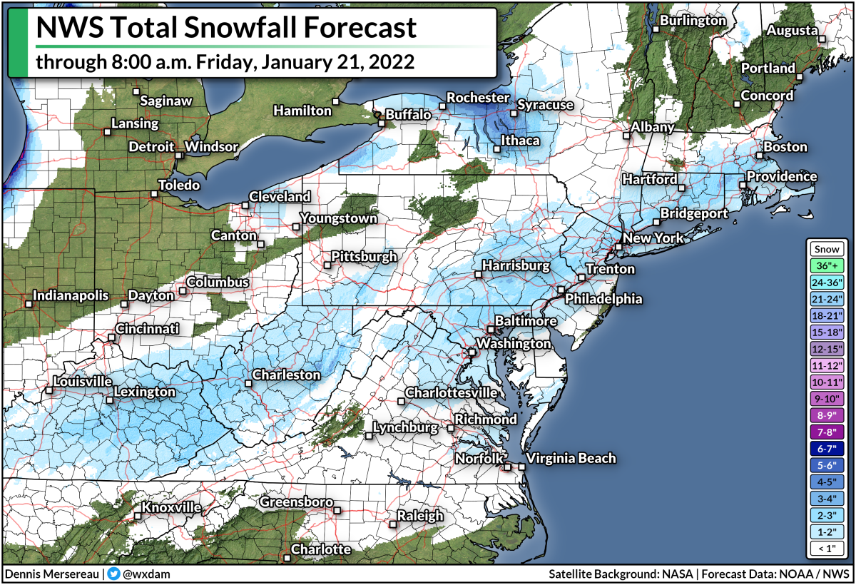
Except for the big Carolinas storm, we won't see big amounts, but it'll be just enough to snarl travel in each of the affected areas.

Burst of Snow Along I-95 Through Thursday Morning

A cold front moving toward the East Coast will bring some rain to the Mid-Atlantic and Northeast beginning Wednesday night and lasting into Thursday morning. Temperatures will rapidly fall behind the front, allowing much of the precipitation to change over to snow across the I-95 corridor.

We could see this changeover from the D.C. metro area up the interstate into Boston, potentially threatening a very tough morning commute for an area that struggles through a tough morning commute on sunny days. 


The National Weather Service expects only an inch or two of snow across the region, but that's plenty to cause serious headaches across the heavily urbanized I-95 corridor.


Light snowfall totals paired with hot traffic can melt the initial snow into a solid sheet of ice on roads, leaving behind a dangerous mess for the remainder of the commute. We've seen this plenty of times, especially in the D.C. area. 

Deep South Ice Threat Thursday Night Into Friday

Farther south, there's a threat for freezing rain and even a bit of sleet, especially across parts of southern and central Texas. Winter weather alerts are in effect for a big chunk of Texas that includes San Antonio, Austin, Corpus Christi, and Laredo. The alerts could stretch into the Houston metro area soon.

A cold front slouching through the Deep South on Thursday will leave behind plenty of cold air at the surface. While surface temperatures drop to or below freezing, things will be just a tiny bit warmer aloft, allowing precipitation behind the front to fall as a messy mix of freezing rain and sleet.

Source: NWS

The National Weather Service expects a light glaze of ice on Thursday night into Friday morning across a sizeable portion of Texas, with totals pushing one-tenth of an inch in many spots. That's not enough to cause widespread tree damage or power outages, but it'll be just enough to make the roads icy, potentially leading to widespread travel issues.

The potential for freezing rain also extends into the northern Gulf Coast, as well, with Baton Rouge, Biloxi, and maybe even Mobile getting in on the chance for a light glaze into Friday morning.

Significant Carolinas Winter Storm On Friday Into Saturday

The smattering of ice and snow will culminate in a significant winter storm across South Carolina, North Carolina, and Virginia beginning on Friday and stretching into the first half of Saturday.

As usual for storms in this part of the country, the northern end of the storm will feature a snow threat while the southern half of the storm is dominated by warmer air and the threat for freezing rain and sleet.

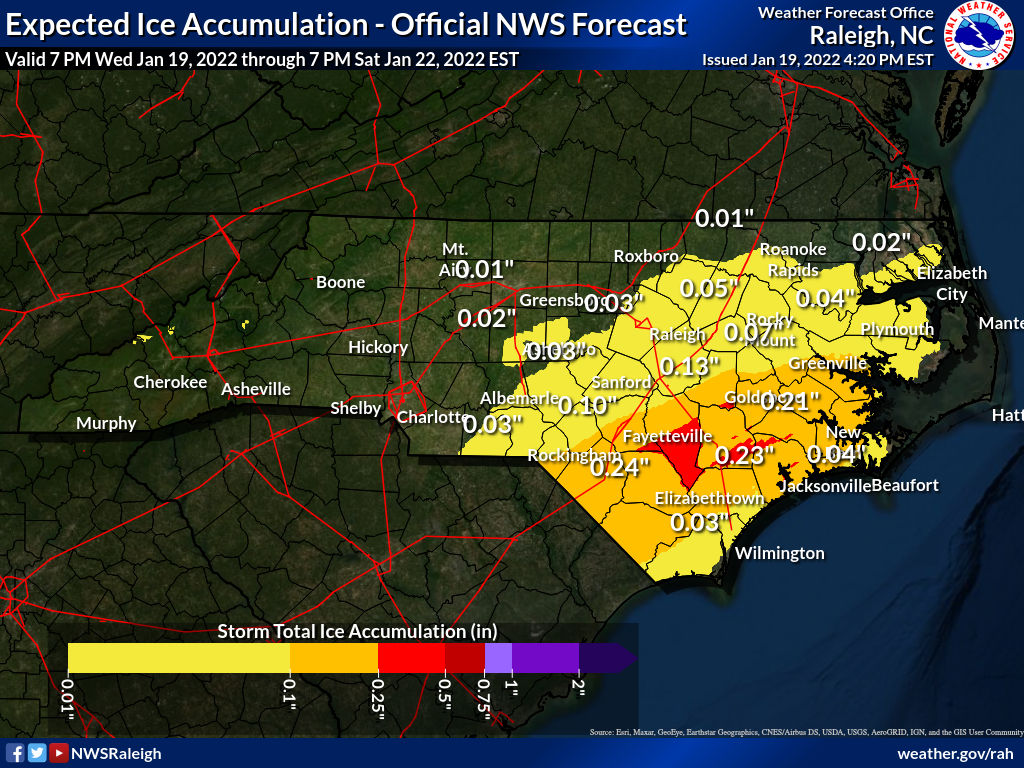
The threat for freezing rain looks particularly concerning across parts of eastern S.C. and N.C., where they can go years between remarkable ice storms. The National Weather Service predicts more than one-quarter of an inch of ice accretion from freezing rain in parts of northeastern S.C. and southeastern N.C., which would lead to widespread tree damage and power outages.

Here's a look at the NWS's ice forecast across South Carolina through Saturday morning:


And the agency's ice accretion outlook for North Carolina over the same period:


The abrupt changes across county/state lines are due to different NWS offices arriving at different forecasts for their areas of responsibility.

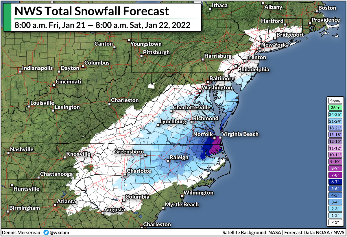
Farther north, snow is in the forecast and some communities could see a decent helping by the end of the storm on Saturday. A bullseye of 6+ inches of snow is possible across northeastern N.C. and parts of the Virginia tidewater, including Norfolk and Virginia Beach.


A couple of inches of snow is also possible farther west, especially around the Raleigh-Durham area and even stretching back into the Greensboro and Charlotte metros.

There is some uncertainty surrounding the westward/northward extent of the wintry precip, though, because of dry air potentially disrupting the system and the track of the low possibly stretching farther off the coast.


You can follow me on Twitter or send me an email.

Please consider subscribing to my Patreon. Your support helps me write engaging, hype-free weather coverage—no fretting over ad revenue, no chasing viral clicks. Just the weather.
 

January 13, 2022

Another Significant East Coast Winter Storm Is On The Way


We're staring down the potential for a significant winter storm across much of the East Coast this weekend. Hefty snowfall totals, significant ice from freezing rain, and gusty winds are all possible as the storm develops and races up the coast.

The Winter Storm Is In Its Infancy

Source: College of DuPage

A system sliding out of the Canadian Prairies will bring heavy snow to much of the Midwest through Friday as it dives toward the southeast. You can see the first pangs of the system's U.S. impacts with the snowfall spreading over the Dakotas tonight. Some folks in Iowa could end the day Friday with double-digit snowfall totals.

This system will swoop into the southeastern United States overnight into Saturday, developing into the winter storm we'll deal with along the East Coast this weekend. The system will rapidly get its act together as it starts moving parallel to the Appalachians, and that's where things get...interesting!

The storm around 8:00 a.m. on Sunday. (NOAA/WPC)

We'll see the greatest impacts in the southeast during the day on Sunday, moving into the Mid-Atlantic Sunday night into early Monday. The bulk of the wintry precipitation will move into the northeast on Monday before lifting away into eastern Canada overnight into Tuesday.

The storm around 8:00 a.m. on Monday. (NOAA/WPC)

Like many eastern winter storms, the precise track of this system will determine if some communities see a lot of rain, a lot of ice, or a lot of snow. This isn't going to be a straight snowstorm for many folks, especially not in the southeastern states. (Could you expect any more?) 

It's (Mostly) Too Early For The Fine Details

It's still too early for the maps I love to make using the National Weather Service's snowfall and ice accretion forecasts. Those forecasts only run out about 72 hours, which would take us to the early stages of the storm on Sunday evening.

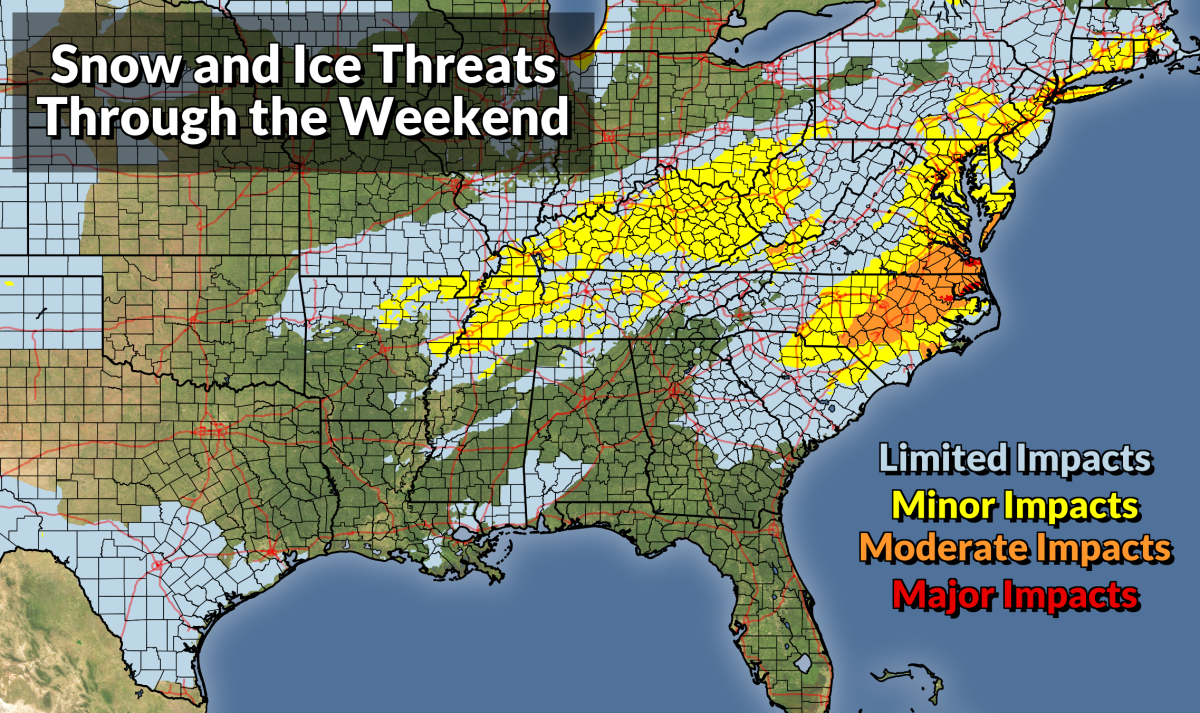
The graphic at the top of this post shows the Weather Prediction Center's Winter Storm Severity Index (WSSI), a new-ish metric the agency uses to convey how impactful a winter storm will be for a certain area based on factors like snow totals, ice accumulations, blowing snow, and flash (sudden) freezes.

It looks like higher elevations in the Appalachians will see a solid snowstorm out of this event, with many areas picking up double-digit totals by the end of the storm. The Piedmont, on the other hand, is looking at a sloppy mess.

For many areas from northern Georgia into central Virginia, we're likely looking at snow changing over to sleet and/or freezing rain, then possibly back over to snow as the system departs on Sunday night.

Throw out all those fantastical weather models that showed something like 18" of snow in central North Carolina. Pfft. Chop that down to a tiny fraction once you account for sleet and freezing rain. This is going to be a mess, and any snow on the ground after the sleet and freezing rain is going to freeze hard into a solid mass of ice on Sunday night into Monday.

I can't not post any snowfall or ice graphics, of course, so here's what we have access to right now, courtesy of NWS Greenville, S.C.

This is their snowfall forecast as of Thursday evening:


And their ice accretion forecast from the same update:


The National Weather Service's forecasts for everyone else in the storm's path will go live through the day on Friday as the storm comes within range and forecasters get a better idea of who will see what. 

This is the type of scenario where weather apps on your phone and the pre-installed weather doohickey on your computer fails to give you the information you need. Getting the temperature and probability of precipitation only gives you a small part of the story.

Some forecasts are more complicated than just a few numbers and icons. You need context to get the full story about this weekend's winter storm, and you'll only get that context from articles like this and posts from (legit!) local meteorologists. This is where your local TV weatherperson comes in handy. Events like this are where their experience and local knowledge really shine.


You can follow me on Twitter or send me an email.

Please consider subscribing to my Patreon. Your support helps me write engaging, hype-free weather coverage—no fretting over ad revenue, no chasing viral clicks. Just the weather.
 

February 14, 2021

Snow, Ice, And Bitter Cold: This Is A Storm The South Will Talk About For Decades


The winter storm moving over the southern United States has all the hallmarks of one of those storms that people talk about for decades. The system will bring significant amounts of snow and ice to areas that don't typically see this kind of wintry weather, and the cold air that follows the storm is on a level the region hasn't seen in more than 30 years.

Meteorologists spent Sunday ogling at the National Weather Service's map of watches, advisories, and warnings across the country:
Source: NWS

That huge swath of pink is a winter storm warning. It covers the entire states of Texas, Oklahoma, and Arkansas, along with most of Louisiana and Mississippi, and continues on into the Northeast. The criteria for a winter storm warning changes from one office to the next based on what a region is used to during a typical winter. Any amount of snow and ice warrants a winter storm warning in parts of Texas, while it takes many inches of snow to trigger the same alert up north. 

It takes lots of things going juuust right for such an intense winter weather event to stretch so far south. The cold air is rooted in the infamous polar vortex. I explained the process more in-depth last week, but a disruption in the polar vortex circulation over the Arctic allowed a piece of the vortex to break off and sit over the Upper Midwest. This disruption allowed cold air to flow straight out of the Arctic and park itself over the central United States for a couple of weeks.

Meanwhile, an upper-level trough moving out of the Rockies led to the development of a low-pressure system over the southern Plains. Conditions are deteriorating across Texas tonight as the low organizes and snow, sleet, and freezing rain fill in. The low will strengthen and move northeast over the next 48 hours, bringing plenty of wintry precipitation from the Gulf Coast to interior New England.


Here's the National Weather Service's snowfall forecast through Wednesday evening. Widespread totals of 6-12" are possible from northern Texas to northern Maine and just about everywhere in between. Forecasters expect the greatest totals in central Oklahoma and central Arkansas, where some communities could wind up with more than a foot of snow by the end of the storm.

Freezing rain will fall closer to the track of the low. A significant ice storm is possible in Louisiana, Mississippi, Tennessee, and along the Appalachians. Down south, this could be the worst ice storm in memory for many folks.
Source: NWS

Everywhere shaded red on the map above could see more than one-quarter of an inch of ice accretion. Some areas could see one-half to three-quarters of an inch of ice, which will cause significant damage.

One thing to keep in mind is that there really isn't much infrastructure in this part of the country to deal with significant amounts of snow and ice. This isn't a situation like North Carolina falling apart when it snows. We see snow and ice frequently enough that it's a shame we can't handle it better than we do.

This is all the way down south. They don't have many snow plows or salt/sand/brine trucks to go around. Most people don't have snow shovels at home or ice scrapers in their cars. You're lucky if you just happen to have sand or rock salt on hand. The region doesn't see winter weather enough to justify spending the money to have an infrastructure in place to deal with it. 

As if the snow and the ice isn't bad enough, tonight's cold is only going to get colder. This winter storm will drag the Midwest's frigid air all the way to the Gulf of Mexico, allowing temperatures to plummet on Monday and Tuesday.

Here are the National Weather Service's high and low temperature forecasts for Monday, Tuesday, and Wednesday:


Bitterly cold air will surge as far as northern Mexico, with low temperatures in the single digits approaching the suburbs of San Antonio. It hasn't been this cold across these regions since December 23, 1989, when it hit -2°F in Fort Worth, 0°F in Waco, 8°F in San Antonio, and a comfy 14°F in Houston. 

Between the snow, the freezing rain, and the surge in demand due to the frigid temperatures, the region will probably experience a tremendous number of power outages this week. Some communities will probably go without power for a week or longer in extreme cases. Trees in places like Louisiana and Mississippi aren't accustomed to the weight of ice on their branches and limbs. It won't take much ice—maybe not even one-quarter of an inch—to bring down limbs and cause trees to snap in half. 
I took this photo just a few minutes after a tree snapped and knocked out the power for 28 hours.

Don't take the threat for prolonged power outages lightly. If you follow me on Twitter, you probably saw that we were without power for 28 hours in my town near Greensboro, North Carolina, after about a third of an inch of ice overnight Friday into Saturday. I try to stay as prepared as I preach when it comes to having the supplies needed to get through an extended outage and it was still tough to get enough battery power and warmth to make it through more than 24 hours in the dark.

It's probably a little too late to get ready now, but if you're in a position where you still have time to prepare, make sure you've got enough batteries, flashlights, water, and non-perishable, ready-to-eat food to get through several days without power. Bottled water (or containers filled with water) are a mainstay on preparedness lists because municipal water treatment plants can lose power as well, potentially hampering their ability to treat or pump water out to you. (It's no joke. My town is under a boil water advisory for two days!)

Oh, and one more thing—if you live in an area expecting ice, stay away from parts of the house where trees and limbs could fall into the roof or walls. It's something people don't really think about until it's too late. Trees are heavy and houses are comparatively weak. Lots of injuries and deaths during ice storms are caused by trees falling into homes.


You can follow me on Twitter or send me an email.

Please consider subscribing to my Patreon. Your support helps me write engaging, hype-free weather coverage—no fretting over ad revenue, no chasing viral clicks. Just the weather.
 

November 29, 2019

A Major Winter Storm Could Bring Blizzard To Northern Plains, Significant Snow To Northeast


A major winter storm will move across the northern United States through early next week, producing a solid blanket of snow from the northern Plains to the Northeast. The heaviest snow will fall on the Dakotas and across the Upper Midwest, where a huge swath of land could see more than 12" of snow by the time the storm is over. Disruptive snowfall totals are also likely across a large portion of the interior Northeast early next week.

The developing storm will come from the same trough that generated the record-breaking low-pressure system in California and Oregon earlier this week. The storm broke the all-time record low air pressure reading for the state of California, with a pressure of 973.4 mb recorded in Crescent City on Tuesday night.

Northern Plains and Upper Midwest


Heavy snow will continue to spread across the north-central United States on Friday night, ending from west to east by Sunday night as the storm scoots east across the Great Lakes.

The National Weather Service predicts more than a foot of snow for a decent chunk of real estate, including the cities of Pierre, Fargo, Grand Forks, and Duluth. Duluth could wind up "winning" the snowfall contest as a result of snowfall enhanced by lake effect snow off of Lake Superior. The city could see a foot-and-a-half of snow by the end of the storm.

Strong, gusty winds associated with the developing winter storm could lead to blizzard conditions in parts of Wyoming, Nebraska, and South Dakota, including Rapid City. A blizzard warning is also in effect in and around Duluth as a result of strong winds blowing off of Lake Superior. A blizzard occurs when sustained winds of 35 MPH and blowing snow reduce visibility to one-quarter of a mile for three consecutive hours. Not only is travel almost impossible during blizzard conditions, but a whiteout can easily disorient someone even on a short trip from the front door to the mailbox.

Northeast


December will begin with the first major snowstorm of the season across much of the interior Northeast as a winter storm threatens to produce more than a foot of snow at higher elevations. This could be a long-duration winter storm, with precipitation beginning on Sunday evening and lasting through the first half of Tuesday in some areas. This is a winter-hardened part of the country, but more than half a foot of snow is difficult to deal with if road crews can't keep up with snowfall rates.

Heavy snowfall totals will come perilously close to the major cities along the I-95 corridor. The gradient between a lot and a little could be especially apparent in Boston, where the current forecast calls for minor accumulations along the coast, but more than 6" of snow just west of the city. A small nudge either way in the storm's track could have a big impact on who sees decent snowfall totals.

It's worth noting that the snowfall forecast above only runs through 7:00 PM EST on Monday, December 2. It's possible that accumulating snow may continue after that cutoff in some areas, so those additional accumulations aren't covered by the National Weather Service's forecast above.

Freezing Rain


It's not all going to be picturesque snow and fluffy drifts. Warmer air on the southern end of the system could allow precipitation to fall as freezing rain for a time, potentially leading to a crust of ice up to one-tenth of an inch thick on exposed surfaces. The greatest threat for freezing rain exists in central and western Pennsylvania, southwestern New York, southern Ontario, and parts of northeast Pennsylvania and northern Michigan.

Even the tiniest coating of ice can make travel by vehicle or foot almost impossible. A crust of ice beneath snow will make a snow-covered street deceptively slick, and freezing rain on top of snow can dramatically increase the weight of the snow and make shoveling a much more intensive task.


You can follow me on Twitter or send me an email.

Please consider subscribing to my Patreon. Your support helps me write engaging, hype-free weather coverage—no fretting over ad revenue, no chasing viral clicks. Just the weather.
 

November 17, 2019

A Coastal Storm Could Bring Freezing Rain To New England On Monday


A nor'easter that brought heavy rain, high winds, and coastal flooding to the Carolinas this weekend could produce a period of freezing rain in New England early next week. The latest forecasts don't call for a full-fledged ice storm, but even a thin crust of ice is dangerous on exposed surfaces.

The storm is quite the looker on satellite imagery today. You can clearly see the low-pressure system's center of circulation as the system wraps up and moves north. Sunday's 1:00 PM EST analysis from the Weather Prediction Center put the storm's minimum central pressure around 994 mb, and its pressure should hold steady or drop a little as it moves toward Atlantic Canada over the next couple of days.

Carolinas Rain And Wind

This is the same system responsible for all the cloudy, drizzly, rainy weather we've seen in the southeast for the past couple of days. The system managed to grow more organized once it left the coast, which is good news for folks in the eastern Carolinas, since double-digit rainfall totals occurred just a few dozen miles off the coast near the NC/SC border.

A cold rain is miserable enough, but this storm was downright windy, too. Winds gusted as high as 36 MPH in Greensboro, N.C., and gusts hit 60 MPH on the state's Outer Banks. The wind and waves led to coastal flooding in areas like Charleston; the water at the Charleston Harbor tide gauge came within a quarter of an inch of major flood stage at high tide on Sunday morning. The outer banks also saw significant storm surge flooding and beach erosion, with some roads in Rodanthe, N.C., completely covered by water and sand early Sunday.

Potential Freezing Rain In New England


The storm is picking up speed as it moves away from the Carolinas, eventually making a wide hook into Atlantic Canada over the next couple of days. The biggest threat from this storm is freezing rain, which could coat most of New England and parts of Quebec and New Brunswick through Tuesday. Winter weather advisories are in effect for most of New England in anticipation of freezing rain on Monday and Monday night.

The best chance for a glaze of ice near the coast will exist on Monday morning before temperature jut above freezing and it all turns to a cold, miserable rain. A greater chance for freezing rain exists inland, where temperatures near the surface should stay at or below freezing for the duration of the storm.

Steady freezing rain will begin in interior New England on Monday evening and continue through the night before changing over to snow. The Weather Prediction Center's most likely ice accretion forecast shows the potential for 0.10" of ice from freezing rain, which is enough to leave a solid, snappable crust on exposed surfaces. This won't rise to the level of a full-fledged ice storm, but even a thin glaze of ice is dangerous for motorists and pedestrians, especially when it's dark and you can't see the slippery surfaces.

Why Ice Instead Of Snow?

Why will the storm start as freezing rain even though temperatures are below freezing at the surface? As the storm draws closer, it'll begin to wrap around a layer of warm air a few thousand feet above the surface. You can see this pretty well in the weather models.
BUFKIT


The above image is from a program called BUFKIT, which uses model data to simulate the SKEW-T charts that meteorologists use to plot out upper-air data from weather balloons. A SKEW-T chart shows the temperature, moisture, and wind speed through a column of the atmosphere. It's like looking at a cross-section with all the data plotted out for you.

The red line on the right traces the temperature through the atmosphere, while the green line traces the dew point through the atmosphere. The altitude on this chart is measured in feet above ground level. This particular graphic shows the GFS model's view of the atmosphere over Montpelier, Vermont, at 8:00 PM EST on Monday. I've highlighted the layers of the atmosphere that are above- and below-freezing.

If this model scenario pans out, the surface temperature in Montpelier at 8 PM on Monday would be about 28°F. However, the air temperature about 2,000 feet above ground level peaks at about 38°F.

Snow will fall until it reaches about 6,000 feet above ground level, at which point it'll start to meet air that's above freezing. Any snowflakes that fall into the thick layer of above-freezing air above Montpelier will completely melt into a liquid raindrop. The raindrop will begin to cool below freezing once it enters that shallow layer of 28°F air right at the surface, freezing on contact with any exposed surfaces.

This nose of warm air across interior New England will slowly erode through Monday night until the entire atmosphere is below freezing, at which point the freezing rain (and possibly some sleet) changes over to all snow. The National Weather Service expects that a couple of inches of snow will fall in northern Vermont and New Hampshire, with up to five inches of snow possible near the Canadian border in northern Maine.

[Top Image: NOAA]


You can follow me on Twitter or send me an email.

Please consider subscribing to my Patreon. Your support helps me write engaging, hype-free weather coverage—no fretting over ad revenue, no chasing viral clicks. Just the weather.