Watches issued for N.C. as powerful Hurricane Erin grows in size

Hurricane Erin remained a powerful Category 4 storm on Monday as the system puttered along east of The Bahamas.
Tropical storm watches and storm surge watches are in effect for portions of North Carolina’s Outer Banks as forecasters expect the storm to grow in size as it recurves through the middle of the week.

The latest forecast from the National Hurricane Center shows Erin steadily moving northwest through the beginning of the week before turning north by midweek as it starts to swing around a ridge of high pressure over the central Atlantic.
Even though the storm’s center should remain far offshore, the storm’s sheer size could bring dangerous conditions ashore for North Carolina’s Outer Banks late Wednesday through the day Thursday.
A tropical storm watch is in effect from Beaufort Inlet to Duck, N.C., while a storm surge watch is in effect from Cape Lookout to Duck, N.C.

The system has steadily grown in size since it reached peak strength as a Category 5 hurricane on Saturday with maximum sustained winds of 160 mph. (I wrote about some of the astounding stats behind Erin’s rise to scale-topping intensity over at The Weather Network, check it out!)
Hurricane Erin will continue to expand its footprint over the next couple of days, growing into an exceptionally large storm by the beginning of the week. This growth could bring tropical storm force winds ashore across the Outer Banks, and the storm’s immensity will help generate a potentially dangerous storm surge along the coast.
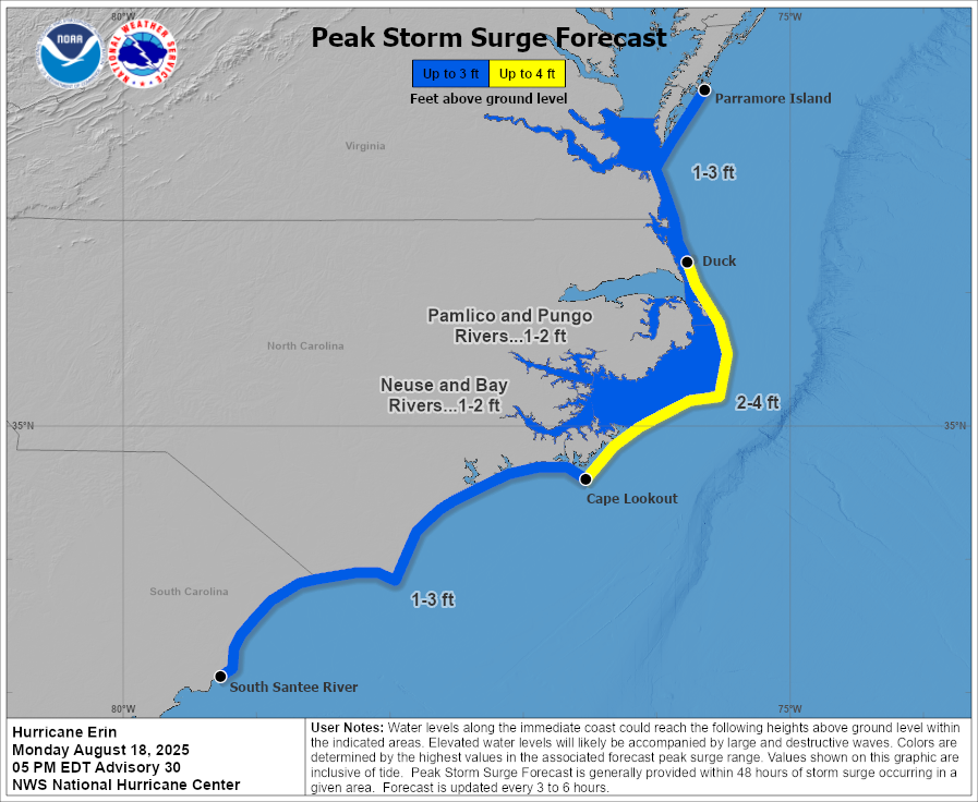
The NHC’s forecast at 5:00 p.m. Monday called for storm surge up to 4 feet above ground level across much of the Outer Banks, with 1 to 3 feet of inundation as far south as Myrtle Beach, S.C., and as far north as the Delmarva Peninsula.
Storm surge flooding is seawater pushed inland by the force of persistent winds. Storm surge is more likely with large storms like Hurricane Erin. Any westward deviation in the track will make coastal flooding more likely.
Rip currents and high waves are likely up and down the East Coast this week as Erin passes through the region.
 |
| Image courtesy of NOAA. |
A rip current is a strong current of water that pulls away from the beach and out to sea. Rip currents don’t pull you under like you see in movies—they quickly pull you away from the shore. Many folks get caught in rip currents because these hazards look like appealing calm spots amid an otherwise choppy ocean.
The best way to avoid a rip current is to simply stay out of the water if red flags are hoisted on the beach. If you’re ever caught in a rip current, don’t panic! Exhaustion can lead to drowning. Calmly signal for help. If you know how to swim, swim parallel to the coastline until the rip current stops dragging you out to sea, then swim back to shore.
Follow me on Facebook | Bluesky | Instagram
Get in touch! Send me an email.
Please consider subscribing to my Patreon. Your support helps me write engaging, hype-free weather coverage—no fretting over ad revenue, no chasing viral clicks. Just the weather.


