August 18, 2025

Watches issued for N.C. as powerful Hurricane Erin grows in size


Hurricane Erin remained a powerful Category 4 storm on Monday as the system puttered along east of The Bahamas. 

Tropical storm watches and storm surge watches are in effect for portions of North Carolina's Outer Banks as forecasters expect the storm to grow in size as it recurves through the middle of the week.


The latest forecast from the National Hurricane Center shows Erin steadily moving northwest through the beginning of the week before turning north by midweek as it starts to swing around a ridge of high pressure over the central Atlantic.

Even though the storm's center should remain far offshore, the storm's sheer size could bring dangerous conditions ashore for North Carolina's Outer Banks late Wednesday through the day Thursday.

A tropical storm watch is in effect from Beaufort Inlet to Duck, N.C., while a storm surge watch is in effect from Cape Lookout to Duck, N.C. 


The system has steadily grown in size since it reached peak strength as a Category 5 hurricane on Saturday with maximum sustained winds of 160 mph. (I wrote about some of the astounding stats behind Erin's rise to scale-topping intensity over at The Weather Network, check it out!) 

Hurricane Erin will continue to expand its footprint over the next couple of days, growing into an exceptionally large storm by the beginning of the week. This growth could bring tropical storm force winds ashore across the Outer Banks, and the storm's immensity will help generate a potentially dangerous storm surge along the coast.


The NHC's forecast at 5:00 p.m. Monday called for storm surge up to 4 feet above ground level across much of the Outer Banks, with 1 to 3 feet of inundation as far south as Myrtle Beach, S.C., and as far north as the Delmarva Peninsula. 

Storm surge flooding is seawater pushed inland by the force of persistent winds. Storm surge is more likely with large storms like Hurricane Erin. Any westward deviation in the track will make coastal flooding more likely.

Rip currents and high waves are likely up and down the East Coast this week as Erin passes through the region. 

Image courtesy of NOAA.

A rip current is a strong current of water that pulls away from the beach and out to sea. Rip currents don't pull you under like you see in movies—they quickly pull you away from the shore. Many folks get caught in rip currents because these hazards look like appealing calm spots amid an otherwise choppy ocean.

The best way to avoid a rip current is to simply stay out of the water if red flags are hoisted on the beach. If you're ever caught in a rip current, don't panic! Exhaustion can lead to drowning. Calmly signal for help. If you know how to swim, swim parallel to the coastline until the rip current stops dragging you out to sea, then swim back to shore. 


Follow me on Facebook | Bluesky | Instagram

Get in touch! Send me an email.

Please consider subscribing to my Patreon. Your support helps me write engaging, hype-free weather coverage—no fretting over ad revenue, no chasing viral clicks. Just the weather.


December 16, 2024

How are the Appalachians ten degrees warmer than lower elevations today?


There's a fascinating temperature profile across the Appalachian Mountains today thanks to winds interacting with the region's rolling terrain.

It's a raw and chilly day across the Piedmont today as daytime high temperatures struggled to break above the 50-degree mark from central Virginia all the way down into northern Georgia. 

Meanwhile, it's a comfortable afternoon high in the Appalachian Mountains, where temperatures are easily 10+ degrees warmer. Asheville was 61°F at 2:00 p.m. while Greensboro was shivering at 51°F. 

A model image showing winds a few thousand feet above the surface on Monday afternoon. (IMAGE: Tropical Tidbits)

What's the deal?

Strong southwesterly winds are blowing through the interior southeast and the Ohio Valley this afternoon as a low-pressure system tracks through the Great Lakes region. Meanwhile, we have a strong center of high pressure over the Northeast that's blowing cold air in from the north.


These chilly northerly winds are slamming into the side of the Appalachian Mountains and forcing that cold air to pool up at lower elevations. This is the infamous cold air damming we see so often this time of year.

The cold air is just shallow enough that it's sitting below the mountain ridges, allowing those warm southwesterly winds to rise over the cold air and blow over the peaks of the Appalachians.

Eventually, we'll see the cold air damming erode through Tuesday morning, allowing daytime temperatures to soar into the mid-60s at lower elevations. 


Follow me on Facebook | Bluesky | Instagram

Get in touch! Send me an email.

Please consider subscribing to my Patreon. Your support helps me write engaging, hype-free weather coverage—no fretting over ad revenue, no chasing viral clicks. Just the weather.


December 4, 2024

Greensboro, N.C., breaks second-longest snowless streak on record


Success! 

A brief burst of snow across central North Carolina on Monday night dropped 0.4" of accumulation at Greensboro's airport, breaking the observation station's 1,038-day snowless streak.

This was the airport's second-longest stretch of consecutive days without any measurable snowfall. Previously, the last time it snowed enough in Greensboro to take a measurement was on January 29, 2022.


A large portion of the region saw a nice dusting of snow as this upper-level disturbance swung through the region. The snow fell vigorously enough to overcome the dry air, giving some communities between Greensboro and Charlotte as much as 1-2 inches of snow by the end of the night.

The snow didn't manage to reach the Raleigh-Durham area, and Charlotte's airport only recorded a trace of snow. A trace of snow occurs when snowfall is observed, but it doesn't accumulate on the ground. The streak of consecutive days without measurable snowfall continues at these airports. 

This was likely our last opportunity to see snow for at least the next two weeks. A ridging pattern will build back over the eastern U.S. through next week, forcing temperatures to return to normal (50s during the day) for a while. 


Follow me on Facebook | Bluesky | Instagram

Get in touch! Send me an email.

Please consider subscribing to my Patreon. Your support helps me write engaging, hype-free weather coverage—no fretting over ad revenue, no chasing viral clicks. Just the weather.


December 2, 2024

Will North Carolina break its three-year snowless streak tonight?


A disturbance crossing the Appalachians on Monday night could bring parts of North Carolina their first measurable snowfall in nearly three years. There's a lot riding on the word "could," though, and it's just as likely that little to no snow falls during this brief window of opportunity.

There could be enough lift in the atmosphere to support the development of a batch of light snow across central North Carolina between about 9:00 p.m. Monday and 3:00 a.m. Tuesday.

Monday afternoon's forecast from the National Weather Service called for less than an inch of snow across south-central portions of the state, including Charlotte and Asheboro. 


One potential hiccup, as always, is the risk for dry air. It's going to be quite cold tonight. Temperatures were already in the mid-30s before sunset, and we're likely going to dip into the middle to lower 20s through the overnight hours.

Very cold and dry air is no good if you're hoping for snow, especially when you're expecting light snow rather than a solid thumping. It's very likely that we'll see snow on radar, but it'll be virga—evaporating long before it ever reaches the ground.

Even so, just the potential for a scattered dusting of snow is big news around these parts.


It's been a warm couple of winters across North Carolina. As of Sunday, December 1, it's been 1,037 days since January 29, 2022—the last time the airports in Greensboro, Raleigh, and Charlotte recorded more than a trace of snow.

Measurable snow counts as 0.1 inches or greater. A trace of snow occurs when snowflakes melt when they hit the ground, leaving behind no accumulation. 

This is the longest snowless streak on record in Charlotte (records back to 1939), the second-longest in Greensboro (since 1928), and the third-longest streak without measurable snow in Raleigh (since 1944). 

We'll see if anything happens tonight. If not, those snowless streaks will keep on rolling for a while longer still.


Follow me on Facebook | Bluesky | Instagram

Get in touch! Send me an email.

Please consider subscribing to my Patreon. Your support helps me write engaging, hype-free weather coverage—no fretting over ad revenue, no chasing viral clicks. Just the weather.


November 24, 2023

Cold air damming brought Greensboro a wild one-hour temperature tango


The weather is pretty darn cool this time of year.

Huge storms romping across the U.S. drag down frigid air from Canada while sucking warm air up from the Gulf of Mexico. Fast-shifting winds spiraling around these sprawling lows can create huge temperature differences over short distances.

Not every sharp temperature gradient is a pure case of Canadian air spilling into the waning remnants of summer. Weather conditions in some parts of the U.S. can depend as much on topography as it does meteorology, and few areas set a better example than central North Carolina.

Greensboro, N.C., anchors the state's Piedmont region. Sitting nearly smack-dab in the center of North Carolina, conditions in the Piedmont are often influenced by the Appalachian Mountains that gently rise over the western third of our state.


We feel this influence the most during the cool season through cold air damming. Chilly winds blowing in from the east or northeast smack against the side of the Appalachians like water held back by a dam. Cold air is dense, so the air can't rise up and over to Tennessee even as warm southerly winds try to scour it out of the region. 

Cold air damming is conspicuous on temperature maps, and it's a major headache for forecasters during winter storms. Frigid air at the surface and warmer air a few thousand feet above ground level is a recipe for sleet and freezing rain—something we see in abundance around here.


But for as tricky as cold air damming can be for precipitation forecasting, just predicting the hourly temperature can prove challenging during one of these setups.

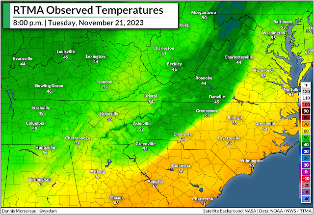
We didn't have to deal with any wintry weather on Tuesday, November 21, but a complex setup led to a wild temperature change in Greensboro over the course of just one hour.

A huge one-hour temperature bounce


Tuesday saw a robust low-pressure system moving into the Great Lakes while a center of high pressure lingered over New England. Northeasterly winds funneled down the coast locked-in a nasty bout of cold air damming in the Piedmont. 

Meanwhile, warm and humid southerly winds flowing into the region courtesy of that Great Lakes low tried their best to scour away the cold air at the surface. It didn't quite work, so that incoming air just rose up and over to fuel a day-long downpour.

The raw and rainy conditions on Tuesday brought the region our first substantial rain in months, which helped dent a growing drought and quench a bevy of wildfires burning throughout the region.


As the low over the Great Lakes dragged its cold front toward the Appalachians, a smaller center of low pressure developed on the eastern side of the Appalachians and tracked north into the N.C. Piedmont. 

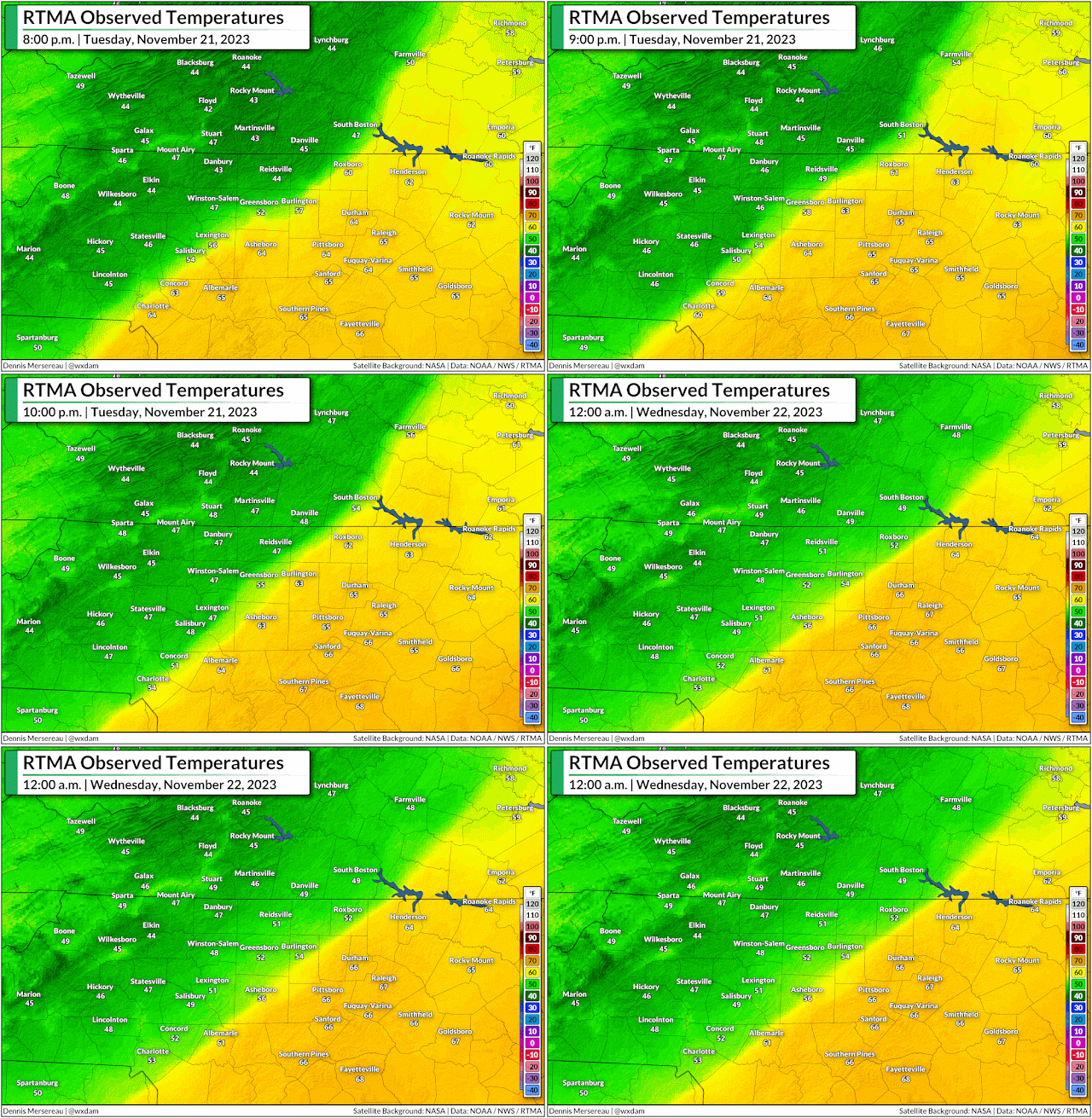
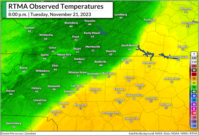
Enhanced southerly winds following that budding li'l area of low pressure lent a hand in trying to scour away the dam of cold air that had built up over the region on Tuesday. Persistence pays off, and communities right near the center of the low did see a significant temperature rise as it passed overhead.

Only briefly, though.

Very briefly.


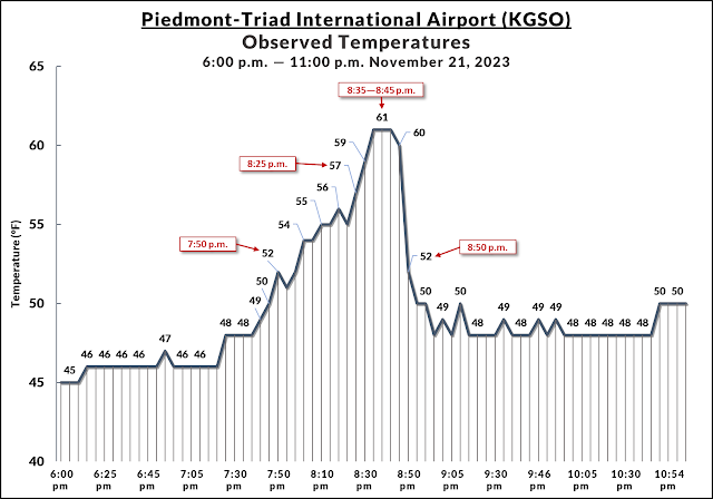
The temperature at Greensboro's Piedmont-Triad Int'l Airport slowly rose from the mid-40s to around 52°F by 7:50 p.m. on Tuesday.

Temperatures fluctuated very fast over the next hour. We saw temperatures warm by one or two degrees every couple of minutes until they peaked at 61°F at 8:35 p.m., remaining there for just ten minutes before the main cold front came in and caused temperatures to plummet even faster than they rose.

Behind the cold front, the temperature at PTI Airport tumbled from 61°F to 52°F in just ten minutes, soon sagging back to around 50°F for the remainder of the night.

It's not one of the more remarkable temperature swings we've ever seen—heck, there are towns on the Plains that can see a 40+ degree temperature drop in just an hour—but the complex circumstances that went into Greensboro's one-hour temperature tango is a fascinating peek at how our vast atmosphere can produce big changes over tiny areas.


Follow me on Facebook | Bluesky | Threads | Instagram | Twitter

Get in touch! Send me an email.

Please consider subscribing to my Patreon. Your support helps me write engaging, hype-free weather coverage—no fretting over ad revenue, no chasing viral clicks. Just the weather.


April 25, 2023

North Carolina's snowy season is over—not that we had one this year


April 24 is a milestone in North Carolina's everlasting battle against wintry weather. 

That fateful Sunday back in 2005 was the latest on record we've seen measurable snow in a major city in North Carolina.

An observer at Asheville Regional Airport recorded 0.1" of snow on that date 18 years ago, a mere dusting among dustings that stands as the latest in the year in modern times we've seen a verified snow measurement in one of the state's big cities. 

Passing this marker in winter weather history doesn't seem to matter much this year, though, seeing as we just witnessed a near-historic snow drought across North Carolina.

A Rare Near-Snowless Winter Across North Carolina

Despite our reputation for falling to pieces the moment someone spots the first flake, it snows just about every year in North Carolina.


Even folks down by the coast sweep away an inch of snow every year or so. Once you're west of Interstate 95, it's actually pretty unusual not to see at least a dusting of snow every year, making this winter's lack of wintry precipitation all the more conspicuous. 

Every weather station in a shade of blue on the map below actually managed to record measurable snow (≥ 0.1") at some point this past winter:


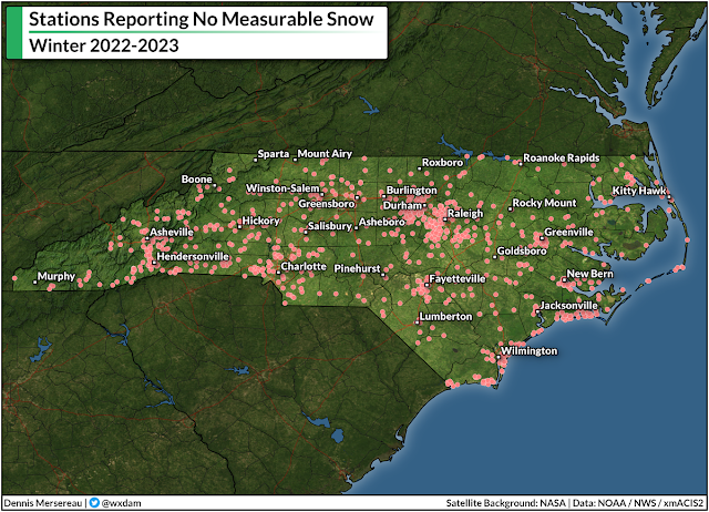
...and every weather station in red on the map below recorded no measurable snow this past winter:


Almost all of this year's accumulating snow remained in the mountains, while a short-lived dusting managed to survive into pockets of the northern piedmont toward the end of March.

The most snow we saw at lower elevations was a "trace," which occurs when snow falls but melts on contact with the ground. Recording a trace gives meteorologists the ability to note that it snowed even though it didn't accumulate.


If you look at how folks drive and react to any predicted amount of snow, you'd think that every winter storm was our very first one. While we're far enough south that winters are generally tolerable to the warmth-inclined, we're also just high enough in latitude to get clipped by snow and ice storms on a regular basis.

Our major cities each benefit from generous weather records that stretch back to the mid-1940s or earlier, a depth that gives us solid frames of reference for what's normal and how fast our "normal" is changing these days.

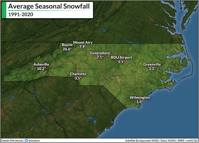
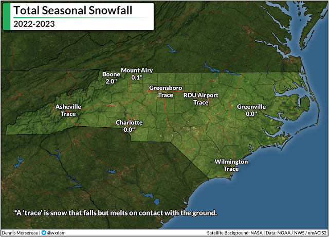
Asheville, for instance, has seen measurable snow every winter for the past 70+ years except for just four. With just a trace of snow recorded at the airport, this year ranks among those four. Boone has recorded snow every single winter since 1928; however, the 2.0" that fell there this winter was the lowest out of nearly a century of routine observations.


It's a similar story in our low-elevation metro areas. The big goose-egg measured in Charlotte this winter was one of just 11 winters where no measurable snow fell. Greensboro's trace of snow made this the sixth winter since 1928 where we couldn't even muster a dusting.

The lack of snow isn't for a lack of precipitation, either. Most stations west of I-95 saw slightly below-average precipitation, only by an inch or so. The mountains and piedmont managed to avoid drought all winter, with "unusual dryness" only starting to creep into northern sections around Rockingham and Caswell Counties here at the end of April.

It could have snowed. It should have snowed. But it didn't snow because it was just too warm to snow.

Record Winter Warmth

Calling the previous season "winter" even feels like an overstatement. It was pre-spring. Spring Junior. Aside from the epic cold snap that nearly wrecked our power grid in the days leading up to Christmas, this winter put a capital M in Mild.

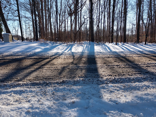
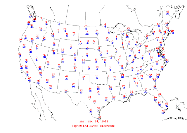
The most "winter" we experienced last season was a lobe of the polar vortex that descended upon the United States right around Christmas. Temperatures plummeted into the single digits for much of North Carolina on Christmas Eve.

Highs and lows on December 24, 2022. (NOAA)

Such a spell of cold weather isn't unprecedented here, but a series of maddening failures and poor decisions on Duke Energy's part plunged hundreds of thousands of North Carolina homes into the dark on those coldest mornings, a series of self-imposed blackouts designed to prevent cascading damage to the power grid as a result of sub-standard power generation.

Other than that little hiccup...it just never really got all that chilly after Christmas.

This was still a capital-M Mild winter even when you factor in the atmosphere over northern Canada taking a brief sojourn south of the border.

Raleigh-Durham International Airport recorded its warmest-ever winter this past season. Boone achieved the same infamous feat. Folks in Charlotte, Greensboro, and Asheville all saw their fourth-warmest winters on record. 

Almost all of this winter's warmth wasn't necessarily driven by days that were mild enough for short-sleeve shirts, but rather nights that repeatedly came in warmer than normal. Average nighttime lows across the state came in well above normal throughout the entire season, widely ranking among the top-three warmest on record.

Source: Climate Central

That's not much of a surprise, unfortunately. Rising low temperatures are one of the most tangible ways we're experiencing climate change here in North Carolina. Low temperatures throughout the year have risen at an astonishing rate over the past couple of decades. The change is so pronounced here in the Triad that we've lost more than three full weeks of subfreezing nights since the 1970s.

We're still going to have finger-numbing cold in winters to come. It'll probably snow next winter, and there's a decent chance parts of the state will see a disruptive thumping from one of those wintry storms.

But the ongoing trend of warmer winter temperatures, especially warmer overnight low temperatures, will reduce our overall chances for snow going forward. It takes just a little more effort and alignment to get snow nowadays.  It's not our parents' climate anymore. We experienced it firsthand this past winterless winter.

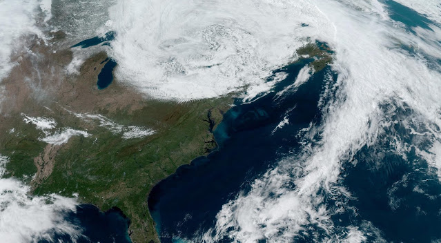
[Top satellite image via NOAA]


You can follow me on Facebook, Mastodon, Twitter, Instagram, or send me an email.

Please consider subscribing to my Patreon. Your support helps me write engaging, hype-free weather coverage—no fretting over ad revenue, no chasing viral clicks. Just the weather.


May 16, 2020

Tropical Storm Watches Issued For North Carolina Coast As Depression Forms In Atlantic


Tropical Depression One formed off the Florida coast on Saturday afternoon, starting this year's hurricane season early for an unprecedented sixth year in a row. Forecasters expect the system to strengthen into Tropical Storm Arthur by early next week as it brushes the North Carolina coast. Heavy rain, rough seas, and gusty winds are likely as the system approaches land.

We've been watching this tropical disturbance for the past couple of days as it slowly moved out of the Caribbean into the southwestern Atlantic. A cluster of heavy showers and thunderstorms persisted long enough for the disturbance to root itself at the surface with a closed low-level circulation. It's easy to see the tight swirl of the circulation on radar out of Melbourne, Florida, this afternoon. 


Environmental conditions are favorable—and its access to the Gulf Stream sufficient enough—that the National Hurricane Center expects the depression to strengthen into Tropical Storm Arthur overnight Saturday into Sunday. It should follow a general north-northeasterly track over the next couple of days, with the center of the storm passing quite close to North Carolina's Outer Banks on Monday.

There are several large-scale features pushing and pulling on the system that will guide its ultimate path. A ridge of high pressure over the western Atlantic will keep it from simply jogging out to sea, while an approaching trough should eventually weaken the ridge and allow the system to curve away from land. The strength of each feature and the timing of the trough's approach are both critical in the exact path of the storm.

A tropical storm watch is in effect for many of North Carolina's coastal counties given the projected path of the storm. It wouldn't take much of a westward deviation from the forecast track to bring the core of the storm closer to the coast. We're probably not looking at too many impacts either way—minor flooding from heavy rain and scattered power outages from gusty winds would be the biggest threat to most folks on land. Rough surf and rip currents will pose a threat to anyone at southeastern or Mid-Atlantic beaches through early next week.

Remember that the cone of uncertainty is the average margin of error in the National Hurricane Center's forecast track during previous hurricane seasons. The center of the storm stays within that cone about 66% of the time. 

The National Hurricane Center issues advisories on storms every six hours—at 5:00 AM/PM and 11:00 AM/PM EDT—with updates every three hours in between when watches and warnings are in effect.

[Satellite Pic: NOAA]


You can follow me on Twitter or send me an email.

Please consider subscribing to my Patreon. Your support helps me write engaging, hype-free weather coverage—no fretting over ad revenue, no chasing viral clicks. Just the weather.
 

February 20, 2020

North Carolina Could See A Li'l Thump Of Snow On Thursday


A fast-moving storm will develop over the southeastern United States on Thursday, potentially dropping a couple of inches of snow across the eastern half of North Carolina and the Virginia Tidewater. There's still some uncertainty around the storm right now—oh, little things like "how much snow will fall?"—but it's likely that the season's first (and only?) snowfall is on the way.

This isn't going to be a mammoth storm, but it will drop a shovelable snow in areas that can go a few winters without seeing much snow at all.

Right now, most meteorologists in the state expect at least an inch of snow across most of North Carolina. The latest forecast from local National Weather Service offices shows the thinking. Forecasters don't expect the system to be a bangin' rock fest like the short-range models keep trying to spit out, though there's a 10 percent chance that the "high-end" totals grow problematic east of Raleigh. The position and movement of heavy bands of snow within the storm leave open the possibility that some towns in eastern North Carolina could see half a foot of snow or more.

Snow should begin in western North Carolina on Thursday morning, spreading east toward the coast through the afternoon hours. The evening rush hour, should there be one, looks messy for just about every part of N.C. and southeastern Virginia.

The storm will clear out to the Atlantic by Friday morning, leaving behind an icy mess that will make it tough to get around on untreated surfaces. Above-freezing temperatures and sunny skies should take care of most roads by Friday afternoon.

This is one of those uncomfortable situations where the final forecast will come down to the wire in a few spots. Some towns will see more snow than they were expecting, while others wind up with little to no snow at all. That's the nature of southern snowstorms.

Charlotte meteorologist Brad Panovich laid it out in plain terms on Wednesday. These flaky southern snowstorms rely entirely on minuscule changes in temperature and moisture throughout the atmosphere. If it's even just a little bit warmer than predicted, snow will change to sleet or freezing rain and the entire forecast is blown to smithereens. Dry air can chomp away at snow like a snack. If the storm moves five or ten miles farther north or south than expected, that also nudges the heaviest bands of snow right along with it.

Forecasters had a tough time getting a handle on this storm until Wednesday morning. Short-range regional models like the NAM, which is great for forecasting thunderstorms but not so much when it comes to snow, have been incredibly bullish on the threat for snow across N.C., consistently painting a swath of double-digit snowfall totals along and east of I-95. Global models like the GFS and European have been less impressed by the storm, lurching back and forth between a few inches and hardly a flurry.

Like many of its neighbors, North Carolina hasn't seen much of a winter so far this winter. It's as if the end of October started skipping and nobody bothered to jiggle the CD player. The coldest we've gotten in Greensboro this season is 20°F—potentially setting us up for the first winter on record without a low in the teens—and most of North Carolina has gotten this far without any measurable snow to speak of, another unusual feat for areas sees at least a dusting or two by the middle of February.

While winter storms aren't out of the question in the southeast in March, encroaching warmth from the south and the increasing angle of the sun makes it more difficult for wintry precipitation to fall with each passing day.


You can follow me on Twitter or send me an email.

Please consider subscribing to my Patreon. Your support helps me write engaging, hype-free weather coverage—no fretting over ad revenue, no chasing viral clicks. Just the weather.
 

April 3, 2019

An Intense April Nor'easter Produced Atlantic Supercells And Snow In The Carolinas


A powerful nor'easter developed off the eastern coast of the Carolinas on Tuesday, bringing a burst of winter weather to a part of the country that hasn't seen much of it this year. The formation and track of the nor'easter has been in the forecast for a few days now, but this storm turned out to be particularly impressive due to its structure and the supercells it produced over the open ocean.


The unusual snow in the Carolinas was the storm's major headline for most of the day. Subfreezing temperatures just above the ground allowed frozen precipitation to reach the surface for a couple of hours from north-central South Carolina to north-central North Carolina. Folks around Charlotte saw the most, with some communities pleasantly surprised to measure about two inches of snow by the time the precipitation came to an end. Snow and sleet accumulated on cars as far north as Greensboro, while it was just pretty to look at closer to the Virginia border where I live.


The snow was mostly conversational and didn't cause too many problems thanks to warm ground temperatures and air temperatures that mostly stayed above freezing during the event. Charlotte only dropped to 36°F during the heaviest precipitation.

It's not common to see accumulating snow this far south this late in the year. This is just the second time in the past century that Charlotte has seen measurable snow during the month of April. Winter weather usually comes to an end across the Carolinas by the middle of March, though there are some exceptions. Parts of North Carolina saw accumulating snow during the second week of April last year, followed a few days later by a severe weather outbreak.

Source: Gibson Ridge


Things got even more interesting once the storm fully exited the North Carolina coast. The low-pressure system that would go on to become a full-fledged nor'easter quickly got its act together this afternoon thanks to a sharply tilted upper-level trough and favorable winds in the jet stream. Meteorologists started buzzing on social media this evening while watching the radar out of Morehead City, NC, as a squall line with multiple embedded supercells played out a few dozen miles off the Outer Banks.

I mean, helloooo:


Those thunderstorms actually wound up helping the low-pressure system deepen even faster than it would have otherwise. For a couple of hours this afternoon, this storm strengthened in part through the same processes that fuel tropical and subtropical cyclones. Strong updrafts in the thunderstorms near the center of the low pulled lots of air away from the surface, causing the minimum central pressure to deepen more rapidly than it would have otherwise. NOAA's Weather Prediction Center put it succinctly this evening: "[the storm is] a good reminder that cyclones exist along a continuum and that determining their type (extratropical, subtropical, or tropical) isn't always clear."

New England will see some gusty winds and a cold rain on Wednesday morning as the bulk of the storm passes the region to the east. Atlantic Canada will feel the full brunt of the storm as it makes landfall in Nova Scotia on Wednesday evening. Environment Canada has warnings out for wind gusts as high as 60 MPH along Nova Scotia's southern coast and 2-3 inches of rain across the province through Thursday. The storm will be somewhat kinder to New Brunswick and Prince Edward Island, bringing an inch or two of cold rain with some heavy snow possible on the western fringe of the storm.


You can follow me on Twitter or send me an email.

Please consider subscribing to my Patreon. Reader-funded news is more important than ever and your support helps fund engaging, hype-free weather coverage.