July 16, 2022

Dangerous Heat, 110°F+ High Temperatures On The Way For Southern Plains


There's a hot summer day and a dang hot summer day. A spell of extreme heat on the southern Plains is set to get worse over the next couple of days as high temperature crank well above the 100-degree mark for much of the region. Highs will easily climb above 110°F for some areas, especially in Oklahoma.

A strong ridge of high pressure building over the western two-thirds of the United States will focus its ire on the southern Plains as we begin the workweek. It's already been pretty darn hot month across the region so far. 12 of the past 16 days at Dallas-Fort Worth Int'l Airport have clocked in at 100°F or hotter so far this month, and that pattern looks to continue as we head into the new week.

The worst of the heat will build on Monday, Tuesday, and Wednesday. The National Weather Service's latest forecast calls for high temperatures to exceed 105°F 

Here are the NWS's predicted highs for Monday, July 18th...


...Tuesday, July 19th...


...and Wednesday, July 20th.


That's brutal heat for anyone. It's going to be exceptionally rough on vulnerable populations such as the elderly, low-income families who don't have adequate (or any) access to air conditioning or fans, folks battling illnesses, and those who have to work outside for long periods of time.


What's going to make the heat even harder is that it's not going to cool off much at night. Tuesday is going to be the hottest day across the region, and nighttime temperatures are going to struggle to fall below 80°F in spots, especially in Oklahoma.

Here's the National Weather Service's predicted low temperatures for Wednesday morning:


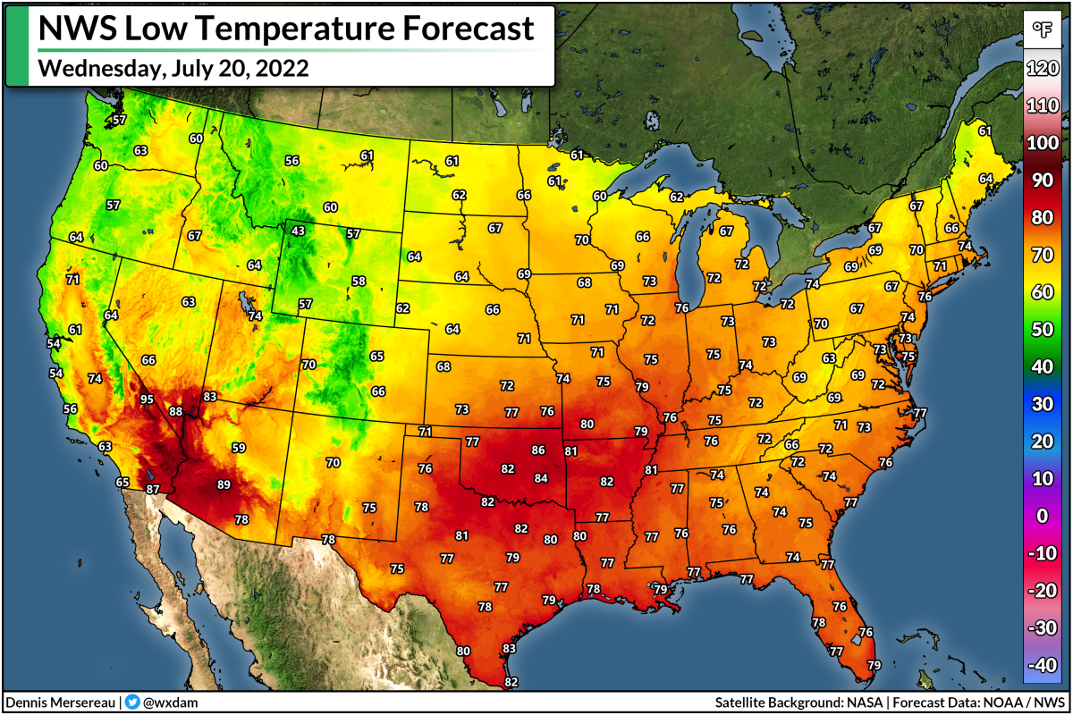
That's a morning low of 86°F in Tulsa. Ouch.

Extreme heat is a compounding risk. Each day of excessively hot temperatures bleeds into the next, without much relief at night, adding stress to vulnerable populations until it becomes too much to bear.

Heat exhaustion is no joke. It can sneak up on you in a hurry if you're not careful. Drink more water than you think you need to drink. Don't push it in the hot sunshine. Find ways to stay cool if you don't have adequate cooling. Check on your neighbors if you know they might have a hard time with the heat.

SOURCE: CDC

The ridge will start to break down a bit as we head later into the week, but broad ridging over the central United States will keep temperatures at or above the century mark for the southern Plains at least through next weekend. This is going to be a rough stretch of hot weather the likes of which this region hasn't seen in a long while. 


You can follow me on Twitter or send me an email.

Please consider subscribing to my Patreon. Your support helps me write engaging, hype-free weather coverage—no fretting over ad revenue, no chasing viral clicks. Just the weather.


July 2, 2022

It's Time For The Atlantic's Annual "Where'd That Tropical Storm Come From?"


Surprise! 

Tropical Storm Colin formed over coastal South Carolina early Saturday morning, becoming the third named storm of the 2022 Atlantic hurricane season.

The storm is...somewhere...in that satellite image above. It takes a trained eye and some imagination to find it, but it's there, according to the experts at the National Hurricane Center (NHC).

Where'd it come from? Who knows! The Carolinas are world-renowned for their barbecue, bad drivers, and spinning up tropical storms from seemingly nowhere.

A small low-pressure system developed off the Georgia coast early Friday afternoon. The NHC noted the system in its 2:00 p.m. tropical weather outlook and gave it a low chance of developing over the next couple of days.

Funny things happen close to the coast during the early summer, though, and the low-pressure system gradually became better organized. The NHC declared it Tropical Storm Colin at 5:00 a.m. on Saturday, saying in its first discussion:

A small area of low pressure formed along a surface trough just  offshore of Savannah, Georgia, yesterday morning and moved inland across the Lowcountry of South Carolina by the evening.  Deep convection formed near the low center as it was moving inland and has persisted and become better organized over the past 6 to 12 hours.  In addition, surface observations and ASCAT data from 02-03 UTC indicated that an area of sustained 35-kt winds had developed offshore and near the coast of South Carolina.  As a result, and rather unexpectedly, Tropical Storm Colin has formed near the South Carolina coast, centered just inland a bit to the northeast of Charleston.

Ain't that somethin'?

Thankfully, Colin is relatively weak and folks getting rained on this long holiday weekend won't notice much of a difference between this tropical storm and a typical dreary day.


The latest forecast from the NHC shows Colin hanging around for another day, moseying over North Carolina's Outer Banks before it loses tropical characteristics. Aside from rip currents at the coast, there's not really much to worry about here—only an inch or two of rain with a low chance for flash flooding along the immediate coast.

There have been a decent number of short-lived tropical storms in recent years that spun-up just before they made landfall in the southeastern United States. 


Last year's Tropical Storm Mindy formed at 4:00 p.m. and made landfall on the Florida Panhandle four hours later. The year before that, Tropical Storm Bertha formed and hit Charleston, S.C., just an hour-and-a-half later. 

Tropical Storm Colin also appears to be the third Atlantic storm in recent memory that strengthened into a tropical storm while the system's center of circulation was over land.

Last year, forecasters upgraded Claudette into a tropical storm twice (!!) while it was over land. The system that became Tropical Storm Julia in September 2016 formed into both a tropical depression and a tropical storm while its center was inland over Florida's East Coast.


You can follow me on Twitter or send me an email.

Please consider subscribing to my Patreon. Your support helps me write engaging, hype-free weather coverage—no fretting over ad revenue, no chasing viral clicks. Just the weather.


July 1, 2022

Tropical Storm Bonnie Could Achieve A Rare Feat: Changing Oceans


Tropical Storm Bonnie (finally) formed in the far southern Caribbean Sea on Friday afternoon, becoming the second storm of the 2022 Atlantic hurricane season. We've been watching this system for a while now, performing its will-it-or-won't-it routine as it skimmed the northern shores of South America.

This tropical storm will be a big deal for folks in Central America. Very heavy rainfall over mountainous terrain will lead to widespread and life-threatening flash flooding across much of Nicaragua and Costa Rica through the weekend.

The National Hurricane Center's 11:00 a.m. EDT update on Friday showed Tropical Storm Bonnie as a minimal tropical storm, moving west a decent clip toward the Nicaraguan coast. Forecasters expect the storm to make landfall on Friday night, lingering through the day on Saturday for many areas.

Even weak tropical systems are bad news when they hit Central America. The region's rugged terrain exacerbates flash flooding from tropical systems that cross the area. The NHC's advisory calls for 4-8 inches of rain, with localized amounts of a foot or more possible.


Bonnie is a strange tropical storm that has the potential to land a spot in the recordbooks. Not only is this one of the farthest-south storms ever recorded—thanks to a strong ridge of high pressure over the Atlantic shunting it far to the south—but forecasters expect it to survive its encounter with Central America and emerge over the eastern Pacific unscathed.

It's very, very rare for tropical systems to cross from the Atlantic to the Pacific intact. Land interaction typically shreds these storms apart, leaving only their cloudy remnants to wander into the adjacent ocean and look for more opportunities to organize into a new storm.

But the latest NHC forecast calls for Tropical Storm Bonnie to cross Nicaragua intact this weekend,  thanks in large part to its swift forward speed and the narrowness of this part of Central America. Forecasters expect Bonnie to emerge in the eastern Pacific on Saturday as a tropical system with the same center of circulation it developed over on the Atlantic side. 

If the storm accomplishes this rare feat, it'll retain its Atlantic name. Forecasters expect Bonnie to continue its Pacific adventure even stronger than it started life, potentially strengthening into a hurricane as it parallels Mexico's western coast heading into early next week.


You can follow me on Twitter or send me an email.

Please consider subscribing to my Patreon. Your support helps me write engaging, hype-free weather coverage—no fretting over ad revenue, no chasing viral clicks. Just the weather.