July 1, 2022

Tropical Storm Bonnie Could Achieve A Rare Feat: Changing Oceans


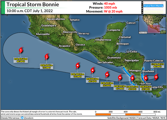
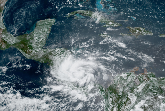
Tropical Storm Bonnie (finally) formed in the far southern Caribbean Sea on Friday afternoon, becoming the second storm of the 2022 Atlantic hurricane season. We've been watching this system for a while now, performing its will-it-or-won't-it routine as it skimmed the northern shores of South America.

This tropical storm will be a big deal for folks in Central America. Very heavy rainfall over mountainous terrain will lead to widespread and life-threatening flash flooding across much of Nicaragua and Costa Rica through the weekend.

The National Hurricane Center's 11:00 a.m. EDT update on Friday showed Tropical Storm Bonnie as a minimal tropical storm, moving west a decent clip toward the Nicaraguan coast. Forecasters expect the storm to make landfall on Friday night, lingering through the day on Saturday for many areas.

Even weak tropical systems are bad news when they hit Central America. The region's rugged terrain exacerbates flash flooding from tropical systems that cross the area. The NHC's advisory calls for 4-8 inches of rain, with localized amounts of a foot or more possible.


Bonnie is a strange tropical storm that has the potential to land a spot in the recordbooks. Not only is this one of the farthest-south storms ever recorded—thanks to a strong ridge of high pressure over the Atlantic shunting it far to the south—but forecasters expect it to survive its encounter with Central America and emerge over the eastern Pacific unscathed.

It's very, very rare for tropical systems to cross from the Atlantic to the Pacific intact. Land interaction typically shreds these storms apart, leaving only their cloudy remnants to wander into the adjacent ocean and look for more opportunities to organize into a new storm.

But the latest NHC forecast calls for Tropical Storm Bonnie to cross Nicaragua intact this weekend,  thanks in large part to its swift forward speed and the narrowness of this part of Central America. Forecasters expect Bonnie to emerge in the eastern Pacific on Saturday as a tropical system with the same center of circulation it developed over on the Atlantic side. 

If the storm accomplishes this rare feat, it'll retain its Atlantic name. Forecasters expect Bonnie to continue its Pacific adventure even stronger than it started life, potentially strengthening into a hurricane as it parallels Mexico's western coast heading into early next week.


You can follow me on Twitter or send me an email.

Please consider subscribing to my Patreon. Your support helps me write engaging, hype-free weather coverage—no fretting over ad revenue, no chasing viral clicks. Just the weather.


August 9, 2019

The Eye Of A Powerful Typhoon Abruptly Swerved Around This Japanese Island

The eye of Typhoon Lekima made an unusual and impressive curve around Japan's Tarama Island on Thursday evening, preventing the center of the storm from making a direct landfall on the tiny island. The unexpected wobble in the storm's track—which only amounted to a couple of miles—is a testament to how minuscule changes in the track of a storm can have dramatic consequences.

Typhoon Lekima approached Japan's Ryukyu Islands with maximum sustained winds of 130 MPH, making it the equivalent of a category four on the Saffir-Simpson Hurricane Wind Scale. The Ryukyus are the archipelago of tiny islands of between the southern Japanese island of Kyushu and the northern tip of Taiwan.
Infrared satellite view of Typhoon Lekima wobbling around Tarama Island on August 8, 2019. | CIMSS, University of Wisconsin
It looked like the eye of powerful Typhoon Lekima would make landfall when it crossed the archipelago on Thursday night. But just as the typhoon's strongest winds approached Tarama Island, the eye of the storm suddenly changed course.

Over the course of a couple of hours, the typhoon's eye performed a sudden curve around the island and missed landfall altogether. This wobble exposed the island of 1,250 people to the eyewall's intense winds for several hours. While the halting loop of Lekima's eye is unusual compared to other storms, wobbles are common in strong cyclones and these minor track deviations it can make all the difference for those in a storm's path.

Typhoon Lekima's abrupt wobble around Tarama Island is a fantastic example of trochoidal motion within a tropical cyclone. The center of a tropical cyclone doesn't move in a straight line. The paths we see on weather maps are smoothed out over a period of several hours. If you tracked the center of a strong hurricane using each update of a weather radar, you'd get a wiggly line—or a trochoid, hence the name—rather than a pleasantly smooth, computerized line.

Trochoidal motion can occur in the track of a storm's eye for a variety of reasons; in Typhoon Lekima's case, this likely included an eyewall replacement cycle and an uneven distribution of strong thunderstorms within the eyewall itself. Eyewall replacement cycles are common in intense storms as a new eyewall forms around the old eyewall, eventually choking off the old core of the storm and taking over as the storm's dominant feature. The center of the storm can wobble a great deal during this process.

Uneven thunderstorms in the eyewall can also cause a storm's eye to wobble. Strong thunderstorms forming in one part of the eyewall can destabilize the eye of the storm, as these new thunderstorms tug the center of the storm toward them. A fast-changing eyewall can push and pull the center of the storm over a couple of miles in a short period of time, causing wild gyrations like we saw when Lekima approached Tarama Island.

Despite the extended blow from the storm, news reports seem relatively positive despite the storm's size and strength. NHK World reported Friday that the storm caused four minor injuries and power outages to the islands affected by the core of the storm.
Super Typhoon Meranti making landfall on Itbayat Island, Philippines, in September 2016. | CIMSS, University of Wisconsin
Wobbling typhoons can pose a grave threat to the vast expanse of tiny, populated islands of the western Pacific Ocean. These storms are so common—and islands so plentiful—that a handful of these isolated communities take a direct or near-direct hit every year.

Super Typhoon Meranti made landfall on Itbayat Island in the far northern Philippines in September 2016, wobbling just right that the entire island wound up in the eye of the storm for a period of time. Itbayat and nearby islands saw heavy damage from the 2016 super typhoon, but suffered no fatalities as a result of the high construction quality of the buildings there.


You can follow me on Twitter or send me an email.

Please consider subscribing to my Patreon. Your support helps me write engaging, hype-free weather coverage—no fretting over ad revenue, no chasing viral clicks. Just the weather.
 

October 2, 2018

Four Scientists in Path of Cat 5 Hurricane Walaka As It Approaches Johnston Atoll


The U.S. Fish and Wildlife Services said on Monday that four scientists are in the path of a category five hurricane threatening Johnston Atoll, an isolated atoll in the central Pacific Ocean. Walaka is one of the strongest storms we've seen in the Northern Hemisphere this summer, and its strongest winds may come within a few dozen miles of the tiny island on Tuesday.

The latest advisory from the Central Pacific Hurricane Center pegged Hurricane Walaka's maximum sustained winds at 160 MPH, making it a category five on the Saffir-Simpson Hurricane Wind Scale. Walaka is the second such storm in the central Pacific basin this year; Hurricane Lane reached the top of the scale before approaching Hawaii in August.

Current forecasts bring Walaka's eye within a few dozen miles of Johnston Atoll on Tuesday afternoon. If the predictions hold true, the atoll would fall on the eastern edge of the eyewall, potentially subjecting it to some of the storm's strongest winds and highest storm surge. Rough waves and storm surge could easily cover much of Johnston Island, most of which lies within a few feet of sea level.

Johnston Atoll is located in the central Pacific Ocean about 800 miles southwest of Honolulu, Hawaii. Johnston Island, the atoll's largest feature, is mostly man-made, measuring about two miles long and about half a mile wide. The island consists almost entirely of a runway and various (largely abandoned) government installations.

Johnston Island played a role in the development of the United States' nuclear arsenal. Numerous nuclear tests were conducted there during the height of the Cold War, and Johnston Atoll was heavily contaminated by radiation after the failure of Bluegill Prime on July 25, 1962. The island's population peaked around the turn of the millennium during the effort to rid the island of pollution from both radiation and Agent Orange, large containers of which were stored there after the Vietnam War.

While Johnston Atoll lacks a permanent human population, the U.S. Fish and Wildlife Service told me late Monday night that there are four members of the U.S. Fish and Wildlife Service's biology field crew currently working on the island. A spokesperson for the agency added in an email:


In preparation for any possible impacts from Hurricane Walaka, the field biology crew secured the year-round field camp. We are working with the U.S. Coast Guard to evacuate the four field crew members on Johnston Island, if weather and circumstances allow. Currently, on island staff are sheltering in place at a steel and concrete structure built to withstand hurricanes.

We are continuing to monitor Hurricane Walaka as it moves through the Pacific and will stay in close coordination with the U.S. Coast Guard as the situation evolves.

The spokesperson added that herbicides, insecticides, and propane tanks were secured before the staff took shelter.


The structure referenced by the agency, pictured in the red box in the Google Earth snapshot above, lies on the northeastern side of the island. Walaka (and its strongest winds/surge) are approaching the island from the south. This may somewhat blunt the effect of storm surge flooding if the crew can't evacuate.

A hurricane watch is in effect for the Papahanaumokuakea Marine National Monument, the long chain of tiny islands and atolls that extend for a thousand miles northwest of the main Hawaiian Islands. The center of the storm is not likely to affect any of the northwestern Hawaiian Islands with the capability of supporting a research population.

The storm will not affect the seven populated islands of Hawaii, though rough surf and rip currents are possible along south-facing shores as the storm passes far to the state's west.


You can follow me on Twitter or send me an email.

Please consider subscribing to my Patreon. Reader-funded news is more important than ever and your support helps fund engaging, hype-free weather coverage.
 

June 11, 2018

Hurricane Bud Expected to Rapidly Intensify Off Mexico's West Coast This Week

The Eastern Pacific Hurricane Season woke up last week and it's off to a formidable start. Hurricane Bud is the season's second hurricane—and the second storm to form in the past week—and it could affect Mexico's west coast over the next couple of days. The storm could make landfall as a tropical storm on the Baja California Peninsula toward the end of the week.


Hurricane Bud is a rapidly strengthening storm. Sea surface temperatures in the eastern Pacific off the coast of Mexico are extremely warm—approaching 90°F in areas to the southeast of the hurricane. This balmy water is miserable for swimmers but it can act like rocket fuel for hurricanes in the right environment. The combination of warm water, low wind shear, and ample moisture will allow Hurricane Bud to strengthen into what is likely to be a major hurricane over the next few days.

The hurricane will move into cooler waters and a less favorable environment later this week, allowing the storm to weaken as it approaches the Baja California Peninsula. The storm will likely bring foul weather to Cabo San Lucas whether or not the center makes landfall. Rough waves, rip currents, gusty winds, and heavy rain are all likely as the storm passes over or near the popular resort town at the southern tip of the peninsula.

Bud is the second hurricane to form in this part of the world in the past week. Hurricane Aletta was the first named storm of the basin's hurricane season and it was quite the looker. The storm unexpectedly strengthened into a category four hurricane with maximum winds of 140 MPH before hitting cooler waters and slowly weakening.


Hurricane Aletta was the perfect hurricane to admire on satellite imagery without a pang of guilt. Most of the storms that form in the eastern Pacific are great to gawk at because, for the most part, they form near Mexico and swirl west without ever affecting so much as shipping lanes let alone populated areas. A storm like Bud, on the other hand, is more problematic.

We routinely ignore the eastern Pacific's tropical cyclones in the United States because they rarely affect us, but the basin can occasionally spin up devastating storms for western Mexico. 2015 saw the strongest hurricane ever recorded in Hurricane Patricia—the storm packed maximum sustained winds of 215 MPH (really!) before weakening to "only" a borderline category five storm at landfall. The worst of Hurricane Odile's category three winds devastated Cabo San Lucas when the storm came ashore in September 2014.

Hurricane season is fully underway in both oceans that surround the United States and Central America. I published a hurricane season primer last week to help you know what to expect this summer and how to keep track of all the forecasts and products issued when a storm forms.

[Satellite: CIRA/RAMMB | Maps: Dennis Mersereau]


Please consider subscribing to my writing on Patreon. Reader-funded journalism is more important than ever and your support helps fund engaging, hype-free weather coverage.

November 25, 2015

Major Hurricane Sandra Breaks Two More Records, Ocean Just Showing Off Now

Hurricane Sandra became a major hurricane today—as I figured it would, but who's keeping score—packing winds of 115 MPH at the 2:00 PM MST advisory. The storm broke the record for the strongest hurricane we've ever seen so late in the year in the eastern Pacific, and it's the eighth major hurricane in that basin this year, which is also a record. It could get just a bit stronger before it begins a steady weakening trend as it hangs a right and heads toward Mexico. Its moisture will continue streaming into the United States over the next couple of days, exacerbating heavy rain and wintry precipitation over the central part of the country.

Nobody likes a show-off, Pacific Ocean. We get it, you're warm. Give it a rest.

[Satellite Image: NOAA]