
The eye of Typhoon Lekima made an unusual and impressive curve around Japan’s Tarama Island on Thursday evening, preventing the center of the storm from making a direct landfall on the tiny island. The unexpected wobble in the storm’s track—which only amounted to a couple of miles—is a testament to how minuscule changes in the track of a storm can have dramatic consequences.
Typhoon Lekima approached Japan’s Ryukyu Islands with maximum sustained winds of 130 MPH, making it the equivalent of a category four on the Saffir-Simpson Hurricane Wind Scale. The Ryukyus are the archipelago of tiny islands of between the southern Japanese island of Kyushu and the northern tip of Taiwan.
 |
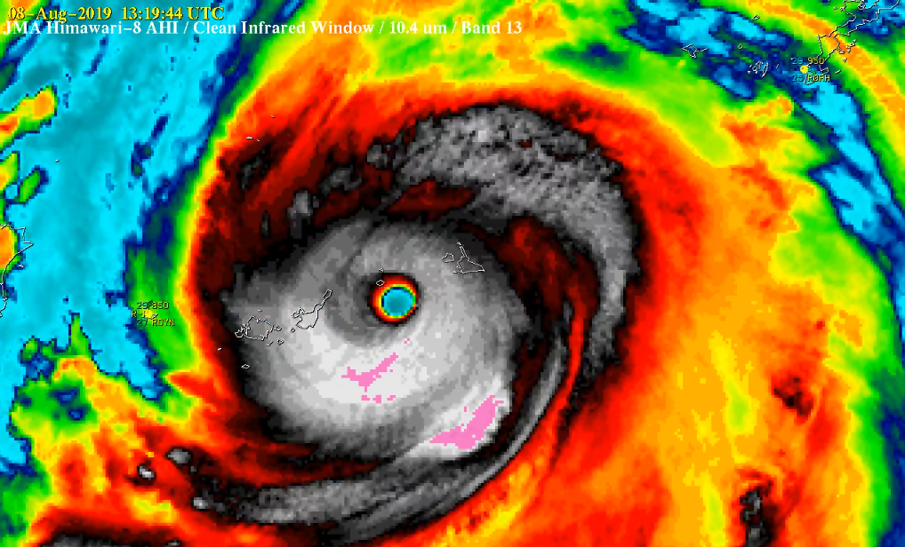
| Infrared satellite view of Typhoon Lekima wobbling around Tarama Island on August 8, 2019. | CIMSS, University of Wisconsin |
It looked like the eye of powerful Typhoon Lekima would make landfall when it crossed the archipelago on Thursday night. But just as the typhoon’s
strongest winds approached Tarama Island, the eye of the storm suddenly changed course.
Over the course of a couple of hours, the typhoon’s eye performed a sudden curve around the island and missed landfall altogether. This wobble exposed the island of 1,250 people to the eyewall’s intense winds for several hours. While the halting loop of Lekima’s eye is unusual compared to other storms, wobbles are common in strong cyclones and these minor track deviations it can make all the difference for
those in a storm’s path.
Typhoon Lekima’s abrupt wobble around Tarama Island is a fantastic example of trochoidal motion within a tropical cyclone. The center of a tropical cyclone doesn’t move in a straight line. The paths we see on weather maps are smoothed out over a period of several hours. If you tracked the center of a strong hurricane using each update of a weather radar, you’d get a wiggly line—or a trochoid, hence the name—rather than a pleasantly smooth, computerized line.
Trochoidal motion can occur in the track of a storm’s eye for a variety of reasons; in Typhoon Lekima’s case, this likely included an eyewall replacement cycle and an uneven distribution of strong thunderstorms within the eyewall itself. Eyewall replacement cycles are common in intense storms as a new eyewall forms around the old eyewall, eventually choking off the old core of the storm and taking over as the storm’s dominant feature. The center of the storm can wobble a great deal during this process.
Uneven thunderstorms in the eyewall can also cause a storm’s eye to wobble. Strong thunderstorms forming in one part of the eyewall can destabilize the eye of the storm, as these new thunderstorms tug the center of the storm toward them. A fast-changing eyewall can push and pull the center of the storm over a couple of miles in a short period of time, causing wild gyrations like we saw when Lekima approached Tarama Island.
Despite the extended blow from the storm, news reports seem relatively
positive despite the storm’s size and strength. NHK World reported Friday that the storm caused four minor injuries and power outages to the islands affected by the core of the storm.
 |
| Super Typhoon Meranti making landfall on Itbayat Island, Philippines, in September 2016. | CIMSS, University of Wisconsin |
Wobbling typhoons can pose a grave threat to the vast expanse of tiny, populated islands of the western Pacific Ocean. These storms are so common—and islands so plentiful—that a handful of these isolated communities take a direct or near-direct hit every year.
Super Typhoon Meranti made landfall on Itbayat Island in the far northern Philippines in September 2016, wobbling just right that the entire island wound up in the eye of the storm for a period of time. Itbayat and nearby islands saw heavy damage from the 2016 super typhoon, but suffered no fatalities as a result of the high construction quality of the buildings there.
Please consider subscribing to my Patreon. Your support helps me write engaging, hype-free weather coverage—no fretting over ad revenue, no chasing viral clicks. Just the weather.