February 11, 2024

From 60s to Snow: The Northeast's Nor'easter's Set To Hit Hard Tuesday


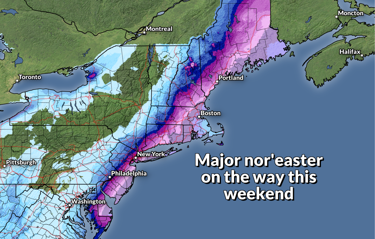
It's been a long wait, but we've finally got a classic nor'easter brewing for the eastern half of the United States.

A foot of snow is likely to fall on Tuesday where temperatures climbed up into 60°F on Saturday. While this one isn't going to bring the blockbuster I-95 snows that weather enthusiasts gush about for the rest of their lives, this will be an impactful storm for a full one-third of the country.

We've got one heck of an upper-level low scooping through the southern half of the U.S. on Sunday and Monday. This feature, along with a ripping-fast jet stream, will help develop and strengthen a robust low-pressure system at the surface over the next few days. 

A model image depicting the upper-level pattern early Monday morning. (PolarWx/Tomer Burg)

Ample moisture streaming into the storm from the Gulf of Mexico will provide plenty of juice to fuel thunderstorms, heavy rains, and eventually heavy snowfall once the storm rolls into the Northeast late Monday into early Tuesday.

Severe weather risk

We're already feeling the start of this robust storm across the south where heavy rain and severe thunderstorms are ongoing from Texas to Mississippi.

The Storm Prediction Center issued an enhanced risk for severe weather on Sunday—a 3 out of 5 on the scale—stretching from the Houston metro area east into central Mississippi, with a broader risk for severe weather radiating out to cover the northern Gulf Coast up toward Birmingham and Atlanta.

The main risk we'll see with any thunderstorms that develop on Sunday will be damaging wind gusts of 60+ mph and hail the size of quarters or larger. A few tornadoes are possible, as well, especially in and around the enhanced risk area.


A risk for tornadoes on Super Bowl Sunday is a pretty nerve-wracking prospect for broadcast meteorologists in the region. It's likely that some CBS affiliates will have to cut into game-day programming for live coverage of tornado warnings.

Local television news stations are required to cover tornado warnings. It's a public service they're compelled to fulfill in exchange for holding a federal broadcast license. Getting the word out that deadly severe weather is imminent is more important than any show or sporting event, angry viewers and hateful comments be damned.

The risk for severe weather will push east into the day Monday, with a threat for damaging wind gusts spreading over most of the southeast as our low-pressure system continues strengthening as it tracks into the Mid-Atlantic.

Sharp cutoff in heavy snowfall totals

After the severe weather wanes, attention turns to the threat for disruptive snows across the Northeast.

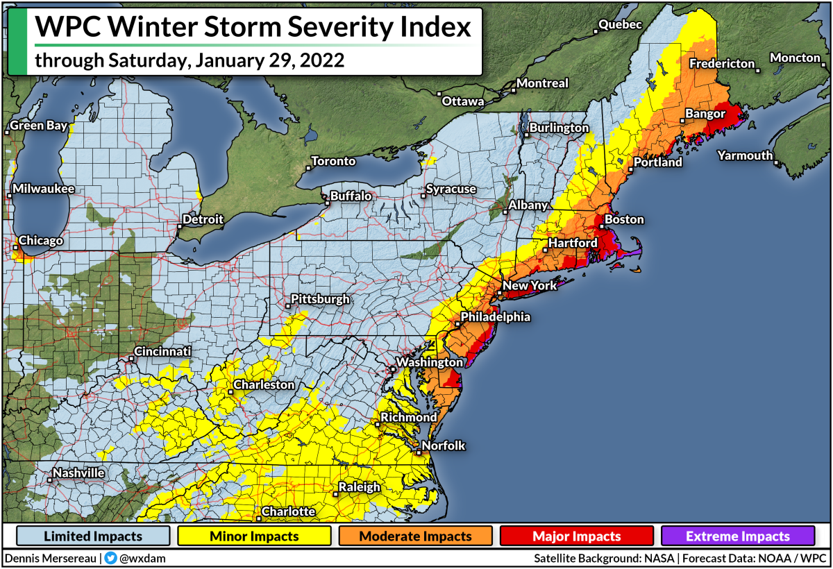
This is going to be an all-or-nothing ordeal for many folks from northern Pennsylvania east toward coastal New England. The Weather Prediction Center's Winter Storm Severity Index (WSSI) shows "major impacts" are likely across eastern Massachusetts, centered around the Boston area, as a result of the very heavy snowfall expected on Tuesday.


Heavy snow will spread over much of Pennsylvania early Tuesday morning as our storm pushes into the region. We'll see snow steadily push east through the morning hours Tuesday as the low-pressure system intensifies and tracks toward the coast. 

This will be a daytime storm for the region, with very heavy snowfall rates and gusty winds plastering northern Pennsylvania through southern Maine into the evening commute before the snow eventually tapers off through the evening and overnight hours.

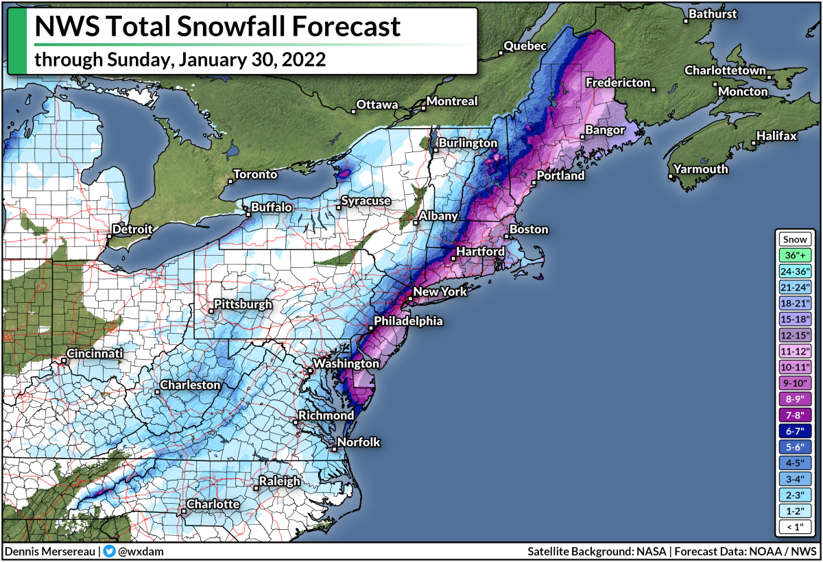
A very sharp cutoff in precipitation on the north side of the storm, combined with a sharp changeover to rain near the center of the low, will produce a swath of heavy snowfall that rapidly tapers to a dusting to the north and south.


Double-digit snowfall totals are likely for portions of northeastern Pennsylvania, upstate New York, northern Connecticut, and just about all of Massachusetts. This is likely going to cause traffic jams across the area, especially if people head to work and school in the morning and then try to head home after the snow begins. 

Slight changes in the track of the storm can have huge implications on snowfall totals with a cutoff this sharp. A nudge of five or ten miles to the north or south will drag those hefty snowfall totals right along with it.

If the current forecasts hold up, this is likely going to be Boston's largest snowstorm in two years. The city's last big-time snowstorm was 23.9" on January 29, 2022. The city's only measured 21.6" of snow in total across all of the storms they've seen in the past two winters combined.

[Satellite image via NOAA]


Follow me on Facebook | Bluesky | Threads | Instagram | Twitter

Get in touch! Send me an email.

Please consider subscribing to my Patreon. Your support helps me write engaging, hype-free weather coverage—no fretting over ad revenue, no chasing viral clicks. Just the weather.


March 13, 2023

Another Atmospheric River Hits California As New England Deals With A Nor'easter


Two major storms will bookend the country on Tuesday, bringing more flooding rains and prolific snows to California while New England deals with its strongest nor'easter of the season.

The Setup

A jet stream firmly parked over the southern half of the United States will set the stage for the two major systems we'll have to deal with over the next couple of days.

Out west, upper-level winds will funnel a rich plume of moisture straight into California. (Stop me if you've heard this one before.) This latest atmospheric river will fuel widespread heavy rains at lower elevations and very heavy snows for the Sierra Nevada.

Back east, the combined lift of a trough digging across Eastern Canada and that strong jet stream over the southeastern U.S. will lead to the rapid development of a low-pressure system off the Mid-Atlantic coast late Monday evening.

This low will spin itself up in a hurry, likely meeting the criteria for bombogenesis, or a "bomb cyclone" as you'll probably hear it termed. This just means that the storm's minimum pressure will deepen very quickly, leading to wicked winds and widespread heavy snowfall across much of New England.

More Flooding For California

A weather alerts map of California today looks like a toddler went at it with a fresh pack of Crayola and a vivid imagination. The state is blanketed with flood watches, wind advisories, high wind warnings, and winter storm warnings for the mountains.

Source: NWS

Wind gusts could reach 50 mph for much of the northern half of California through Wednesday, with gusts up to 70 mph possible along the coastline and elevations above 1,000 feet. Those winds could easily lead to downed trees and power outages, especially with soils soaked from all the rain over the past couple of weeks.

There's plenty more rain where that came from. The latest forecast from the Weather Prediction Center paints widespread rainfall totals of 3-5 inches along the coast, with up to 2.5 inches in the Central Valley and higher totals up north. Much of that precipitation in the mountains will fall as snow, with five feet of additional snow possible above 8,000 feet. 


This latest slug of rain and snow will add further stress to the region's waterways, many of which already spilled over their banks with the round of precipitation a few days ago.

As always, stay alert for flooding and be prepared to change your travel route if you come across a flooded road. It's impossible to tell how deep the water is until it's too late, and it only takes a few inches of moving water to lift a vehicle and carry it downstream. California's hilly terrain increases the odds that there may not even be a roadway left under the floodwaters.

Heavy Snow And High Winds For New England

Meanwhile, the East Coast will soon deal with a storm that could be its most significant thump (in fact, one of its only bouts) of wintry weather this year.

A classic nor'easter will spin up off the East Coast tonight and roar through early Wednesday morning, targeting much of New England with heavy snow and high winds for the day Tuesday.


The storm will really get cranking early on Tuesday morning, plastering almost everyone from northeastern Pennsylvania to coastal Maine with double-digit snowfall totals by the time the storm is over on Wednesday.

Most of the snow will fall north and west of I-95, sparing Philly and New York from much more than a dusting at best. Higher elevations in upstate New York could see up to two feet of snow.

Boston is going to be right on the borderline between a nuisance and a solid storm, with about 6-8 inches of snow in the forecast right now—with much lower totals just east and much higher totals just west. It wouldn't take much of a nudge in the storm's ultimate track to push that fine line in either direction. I don't admire local meteorologists up there right now.

Strong winds of 50-60 mph are likely during the storm, which will lead to tree damage and power outages for many location. This is going to be a wet, sloppy snow, to boot, which will weigh down trees and power lines and make damage and outages even more likely. Coastal flooding is also possible.

Heavy snowfall rates and high winds will lead to reduced visibility during the height of the storm, with whiteout conditions possible at times. If you have to travel through the area, it'd be a good idea to get where you need to go by Monday night and plan to stay put for a couple of days. 

[Top Image: Tropical Tidbits]


You can follow me on Facebook, Mastodon, Twitter, Instagram, or send me an email.

Please consider subscribing to my Patreon. Your support helps me write engaging, hype-free weather coverage—no fretting over ad revenue, no chasing viral clicks. Just the weather.


January 27, 2022

A Powerful Nor'easter Will Bring Hefty Snows To Parts Of The Mid-Atlantic And Northeast


A powerful nor'easter will develop off the Mid-Atlantic coast on Friday night and race toward the Canadian Maritimes into this weekend. The track of the storm is extremely frustrating for meteorologists and residents alike—a tiny wobble to the west could bring major snowfall totals into big cities along I-95, while a small shift to the east could leave those cities with minor accumulations.

Winter storm watches and warnings are in effect from N.C.'s Outer Banks to the international border in Maine ahead of the impending system. The low-pressure system will develop off the North Carolina coast on Friday night, rapidly strengthening as it slides up the East Coast through the first half of Saturday.

Snow will begin over the Mid-Atlantic on Friday night as the system develops. A few inches of snow are possible into Virginia and North Carolina, with higher totals possible in the mountains.

For what it's worth, it only takes an inch or two of snow to make a serious mess of things in these areas. You get a little bit of snow on the roads when temperatures are hovering around freezing. Hot traffic drives over the fresh snow which compacts and melts it, leaving it to freeze into a sheet of ice that all the traffic behind slips and slides on. It only takes a little bit to make a big headache.

Anyway, the bulk of the storm is going to affect the coast overnight Friday through Saturday afternoon, and it's going to be such a close call for the big cities along Interstate 95.


The Weather Prediction Center's Winter Storm Severity Index (WSSI) does a good job telling the story of where the most impactful winter weather will take place. The red along the coast from the Delmarva Peninsula to the international border in Maine shows where communities will feel "major impacts" from steep snowfall totals and blowing snow from gusty winds.

If you look real close, you'll see a smattering of purples—"extreme impacts"—along the coast from Cape May, New Jersey, up through Eastport, Maine. This is where high winds will likely lead to blizzard or near-blizzard conditions for a time during the storm Friday night through Saturday morning.

It's looking increasingly likely that we'll see disruptive snowfall totals from southern Delaware up through Maine, with more than a foot possible in parts of Massachusetts and Rhode Island. Millions of people live right along the fine line between conversational snow and "big deal" snow.


Small shifts in the track of the system can lead to (seemingly) dramatic swings in forecast snowfall totals, as seen by the widely spread (and widely mocked) tweet from NBC News that said New York City could see between 2 and 20 inches of snow this weekend.
The Weather Prediction Center's forecast for 8:00 AM EST on Saturday, January 29, 2022. [NOAA/WPC]

Nor'easters really are systems where track is everything. Tiny shifts to the east or west can have huge implications when it comes to snowfall totals. Think about what a band of heavy snow looks like on radar—not only is it narrow to begin with, but the sharp edges of the heavy snow can mean two neighboring towns can experience two completely different outcomes.

There's a lot of frustration over the "well, we might get nothing, or we might get walloped," but really, that's just how it works with nor'easters. It sucks. It's frustrating. But that's how these storms go, especially when millions of people occupy a very slim swath of real estate near the coast. A shift of a dozen or two miles to the west could bury those towns, and a similar shift east could leave them without much to speak of. 


We're likely going to see significant snowfall totals across the Mid-Atlantic and Northeast. Thursday evening's forecast from local National Weather Service offices shows double-digit snowfall totals from the Delmarva to Maine, with parts of Rhode Island and eastern Massachusetts potentially scoring two feet of snow out of this system.

Just look at that western cutoff between a foot of snow and half that much. It wouldn't take much of a westward nudge in the storm's track to bring those hefty totals right into the megalopolis. That's why meteorologists have collectively tugged at their collars over this forecast. 

If you're in an area expecting heavy snow and high winds, it'd be a good idea to find (or get) flashlights and a few battery refills just in case your power goes out on Friday night or Saturday. You don't want to drain your cell phone battery on the flashlight feature. Also, remember to throw your phone on the charger before going to bed on Friday. It's also a good idea to have some rechargeable battery packs for your cell phone so you don't have to trudge out to the car for a recharge (or, worse, completely go without). 

Also, stay mindful of trees or tree limbs that might loom near portions of your home. Most injuries during windstorms occur when trees fall into homes. If you have a large or unstable tree near your house, try to avoid those rooms during the high winds whenever possible. Better safe than sorry and all that.


You can follow me on Twitter or send me an email.

Please consider subscribing to my Patreon. Your support helps me write engaging, hype-free weather coverage—no fretting over ad revenue, no chasing viral clicks. Just the weather.
 

January 30, 2021

Oh No. Oh No. Here Comes The Snow.


A decent nor'easter will sweep across the Mid-Atlantic and Northeast over the next couple of days, bringing heavy snow to folks from western North Carolina through Atlantic Canada. This could be the biggest snowstorm to affect the Washington D.C. area in two years. The storm will unfold in two parts, the first affecting the Mid-Atlantic on Sunday and Monday, with the stronger storm—and highest snow totals—sweeping across coastal communities of the Northeast on Monday and Tuesday.
Source: Tropical Tidbits

This bout of snow and ice is really two different storms creating one big mess. You can see the evolution of the two storms using the model image above, from Tropical Tidbits, which shows the GFS model's guidance from Saturday night through Tuesday evening.

The first low-pressure system moved across the Midwest and Ohio Valley on Saturday, bringing heavy snow to Wisconsin, Illinois, and Indiana. Some lucky folks (or unlucky folks, depending on your level of Winter Hatred) will see more than half a foot of snow by the time the precipitation ends. This system will slide into the Mid-Atlantic overnight Saturday into Sunday and produce ice over parts of North Carolina and southern Virginia while laying down a blanket of snow in the D.C. and Baltimore areas.

A pre-event band of snow already moved through N.C. and Virginia on Saturday evening, dropping a quick dusting to inch of snow across the affected areas before the main storm moves in later on. I took the pic at the top of the post just before publishing this. I stopped writing to go outside and sample the quality and purity of the snow. You know...for science.

That first storm will start to wind down as the upper-level trough sharpens over the East Coast. The resulting classic trough will generate a classic nor'easter off the coast of New Jersey. Snow will crank in earnest beginning on Monday morning as the low develops and takes over. Fairly heavy snow rates, possibly a few inches an hour, are likely across parts of eastern Pennsylvania, New Jersey, NYC, and Long Island as the nor'easter deepens. Snow will taper off on Monday night and Tuesday from south to north as the storm moves off toward Atlantic Canada.

Here's National Weather Service's snowfall forecast from Saturday evening through Tuesday evening, including snow from the first storm to the west and most of the subsequent storm back east:


There's pretty good agreement between the offices that the greatest snowfall totals will occur during the peak of the nor'easter. Someone will wind up getting a foot or more by the end of the storm. As always, tiny changes in the track of the storm could result in big differences in the final accumulations. If the storm moves a bit west or east, the axis of heavy snow will follow suit.

Ice will be a problem farther south. Winter storm warnings are in effect for freezing rain in southern Virginia and parts of the North Carolina Piedmont (which is where I live). It'll be cold enough at the surface for snow, but an intrusion of warm air a few thousand feet above the surface will force snowflakes to melt into liquid raindrops. These raindrops will fall into that subfreezing air at the surface and freeze on contact with exposed surfaces. Some areas could see as much as one-quarter of an inch of ice accretion, which could lead to tree damage and power outages.


You can follow me on Twitter or send me an email.

Please consider subscribing to my Patreon. Your support helps me write engaging, hype-free weather coverage—no fretting over ad revenue, no chasing viral clicks. Just the weather.
 

December 15, 2020

A Significant Winter Storm Will Plaster The Mid-Atlantic And Northeast This Week


Gird your loaves and invest in milk futures: a snowstorm's comin'. A big one, in fact. Parts of the Mid-Atlantic and Northeast are getting ready for the season's first big-time snowstorm. Some areas will see more snow than they've seen in two years—of course, that's not as impressive as it sounds considering last winter's snows were a dud in the Mid-Atlantic. As we see with so many coastal storms, the precise track of the storm will determine whether you get blanketed by snow or shrouded by bitter disappointment.

The Setup

A trough in the jet stream will drive the formation of the low-pressure system that will become our mid-week winter storm. A low-pressure system will develop in the Carolinas on Tuesday night and move up the coast through Thursday. The system will have plenty of moisture and cold air to work with, so there's not much wishy-washiness about whether or not the system will produce big snowfall totals. There's going to be a sharp cutoff between blockbuster snows and a nuisance, so the ultimate track of the storm will make a big difference on who sees huge snows or a cold rain.

The Timing

Rain will begin over the southeast on Tuesday night and Wednesday morning as the low-pressure system starts to develop. The storm will pick up intensity in a hurry as it approaches the Mid-Atlantic, which is when wintry precipitation will start on the northern side of the storm.

Freezing rain will likely begin in western North Carolina and parts of western Virginia on Wednesday morning and afternoon. Temperatures will eventually climb above freezing across areas expecting freezing rain, so the question will be how long it takes the subfreezing air at the surface to erode. The longer it sticks around, the thicker the crust of ice will grow. It shouldn't be a big ice storm, but any crust of ice is dangerous when there's ice on the roads and if tree limbs or power lines snap under the weight. Temperatures should—should!—climb above freezing by late afternoon across most areas expecting ice.

Farther north, the snow will begin on Wednesday afternoon west of D.C. and spread north through the afternoon and evening hours. Precipitation will taper off on Thursday morning from west to east. 

The Track

Six runs of the GFS model showing how tiny shifts in the storm's position can move around the rain/snow line. SOURCE: TropicalTidbits.com

Track track track. Track? Track. Okay, I got that word out of my system. It'll be like Edith and the cling peaches. Won't say that word again.

The structure of coastal storms like this is usually pretty textbook. The rain/snow line follows close to the tra—uh, path—of the center of the low-pressure system, so you wind up with rain to the south/east and snow to the north/west. You get a pretty heavy shield of snow to the northwest of the low that accounts for the greatest snowfall totals. If that line sets up near I-95, you wind up with those memorable storms that immobilize big cities for an entire week.

Since precipitation type and totals are so heavily dependent on the storm's motion, getting it right is crucial to the forecast. If the storm moves 20 miles to the right or to the left of what was forecast, the rain/snow line and shield of heavy snow will follow suit. That could result in surprises and disappointments.

Right now, it's likely that any jog in the storm's motion would be a northerly jog, which would push the heaviest snowfall totals north.

The Snow


Speaking of surprises and disappointments, check out that tremendous cutoff between lots of snow and not much at all. That's why even a tiny shift in the storm's motion could result in a tremendous difference in snowfall amounts for these densely populated communities.

Right now, the National Weather Service's forecast calls for more than a foot of snow from northwestern Virginia to southern Connecticut, which is a vast swath of real estate at risk of seeing a great deal of snow. The greatest totals are likely in central Maryland, eastern Pennsylvania, northern New Jersey, and the Hudson Valley in New York—these areas could see more than a foot-and-a-half of snow by the end of the storm.

Again, it won't take much for that sharp cutoff in totals to nudge a dozen or two miles to the right or to the left, which could have big implications for densely populated communities along I-95. When you're preparing for a storm, it's always best to prepare for the worst so you're ready no matter what happens.


The Weather Prediction Center's new Winter Storm Severity Index (WSSI) shows major to extreme impacts across areas expecting more than a foot of snow. The greatest disruptions are likely in eastern Pennsylvania and northern New Jersey, where a combination of deep snow on the ground and the weight of the snow on trees, power lines, and flat roofs could cause major issues.

Across the hardest hit areas, travel will be all but impossible during and immediately after the storm. It could take several days for crews to reach residential areas. Hopefully the fact that travel is at a minimum and work/school is predominately conducted at home these days will make it easier for crews to safely clear the roads in a reasonable amount of time.

Now that most trees have lost their leaves and the snow isn't going to be particularly wet, there shouldn't be a widespread risk for power outages, but this much snow built up on power lines and tree limbs could lead to some power outages.

It's likely that the snowpack will stick around for a while after the storm—it doesn't look like there are any significant warmups on the way for the eastern states.


You can follow me on Twitter or send me an email.

Please consider subscribing to my Patreon. Your support helps me write engaging, hype-free weather coverage—no fretting over ad revenue, no chasing viral clicks. Just the weather.
 

December 4, 2020

The Season's First Big Nor'easter Could Bring A Foot Of Snow To Interior New England


The first significant nor'easter of the season will bring heavy snow to parts of New England this weekend. It's got everything: a sharp cutoff in totals, uncertain snow amounts, and small changes in the storm's path having a big impact on what ultimately happens. Hey, at least we're not talking about hurricanes anymore, right?

The storm that will become the nor'easter—which, by the way, doesn't have a name, since we don't name winter storms in the United States—will get its act together tonight over the southeastern states. Precipitation will begin as heavy rain and thunderstorms in the Carolinas as the low-pressure system organizes and starts to move toward the coast.

Here's what to expect.

Rain And Severe Thunderstorms


Heavy rain and thunderstorms will begin to overspread the Carolinas tonight through early Saturday morning. Not only will the rain be quite heavy at times—with a quick inch or so of rain possible—but there's a possibility for severe thunderstorms in eastern North Carolina.

The Storm Prediction Center issued a slight risk for severe weather across the far eastern portion of the state through Saturday morning, with a marginal risk extending westward into the Piedmont Triad.

The greatest risk will be damaging wind gusts of 60 MPH, but tornadoes are possible, especially in the slight risk area in eastern N.C. There will be enough wind shear on the eastern side of the developing nor'easter that discrete thunderstorms ahead of the main line could rotate and produce tornadoes.


Elsewhere, it's just a heavy rain threat. Precipitation will fall as rain across most inland and coastal areas until you reach deep into New England. Even areas that could see snow at the end of the storm, such as Boston and Portland, will see rain for most of the storm.

The heaviest totals are likely along the coast—Cape Cod could see up to two inches of rain by the end of the storm. This isn't a blockbuster rain event, but it could cause some flooding issues, especially where any storm drains are clogged by fallen leaves.

Snow


Plenty of cold air over interior New England will ensure that the northwestern side of the storm will produce the first decent snowstorm of the year for the region. The latest forecast from the National Weather Service calls for more than half a foot of snow through much of Massachusetts, Vermont, New Hampshire, and Maine, with the greatest totals likely from northern New Hampshire northward into Quebec. Augusta, Maine, could see more than a foot of snow by the end of the storm.

Precipitation will begin as rain on Saturday, quickly changing over to snow as the evening wears on. Snow will continue through Sunday afternoon as the storm pulls away into Atlantic Canada. There's a decent chance that rain will end as snow near the coast, possibly bringing a light blanket of snow to Boston.


The first big snow of the year is a big deal no matter where you live because it takes a little while to acclimate yourself to shoveling, walking, and driving in the stuff. The Weather Prediction Center's new Winter Storm Severity Index (WSSI) calls for minor to moderate impacts across the region, mostly for a combination of snow amounts and the "snow load," which is the weight of wet snow on trees, power lines, and roofs. This is going to be a wet snow, so that'll increase the risk for downed tree limbs, power outages, and it'll make it more difficult to shovel.

It's important to remember one of the rules of winter weather forecasting: small changes in storm track have a big effect on the final result. This especially holds true for nor'easters. If the storm moves one or two dozen miles to the east or west of what forecasters expect, it would move the axis of heavy snow accordingly. That could mean that areas expecting minor (or no) accumulations wind up with a shovelable snow, while areas bracing for a big thump get less than expected. Keep checking forecasts this weekend so you're ready if things change in your area.

Wind

It's going to get pretty windy behind the system. Gusts of 40 MPH are possible well behind the system into the Carolinas, which could lead to sporadic power outages where trees, already stressed by the parade of storms this summer and fall, struggle to keep their grip in the wet soil.

Up north, gusty winds will follow the snow on Sunday. Wet snow is bad enough on tree limbs and power lines, but the added stress of gusty winds could cause some issues. The risk for power outages ticks up with heavier totals, so folks from Worcester, Massachusetts, north through interior Maine should be ready for at least a day or so without power, just in case.


You can follow me on Twitter or send me an email.

Please consider subscribing to my Patreon. Your support helps me write engaging, hype-free weather coverage—no fretting over ad revenue, no chasing viral clicks. Just the weather.
 

November 17, 2019

A Coastal Storm Could Bring Freezing Rain To New England On Monday


A nor'easter that brought heavy rain, high winds, and coastal flooding to the Carolinas this weekend could produce a period of freezing rain in New England early next week. The latest forecasts don't call for a full-fledged ice storm, but even a thin crust of ice is dangerous on exposed surfaces.

The storm is quite the looker on satellite imagery today. You can clearly see the low-pressure system's center of circulation as the system wraps up and moves north. Sunday's 1:00 PM EST analysis from the Weather Prediction Center put the storm's minimum central pressure around 994 mb, and its pressure should hold steady or drop a little as it moves toward Atlantic Canada over the next couple of days.

Carolinas Rain And Wind

This is the same system responsible for all the cloudy, drizzly, rainy weather we've seen in the southeast for the past couple of days. The system managed to grow more organized once it left the coast, which is good news for folks in the eastern Carolinas, since double-digit rainfall totals occurred just a few dozen miles off the coast near the NC/SC border.

A cold rain is miserable enough, but this storm was downright windy, too. Winds gusted as high as 36 MPH in Greensboro, N.C., and gusts hit 60 MPH on the state's Outer Banks. The wind and waves led to coastal flooding in areas like Charleston; the water at the Charleston Harbor tide gauge came within a quarter of an inch of major flood stage at high tide on Sunday morning. The outer banks also saw significant storm surge flooding and beach erosion, with some roads in Rodanthe, N.C., completely covered by water and sand early Sunday.

Potential Freezing Rain In New England


The storm is picking up speed as it moves away from the Carolinas, eventually making a wide hook into Atlantic Canada over the next couple of days. The biggest threat from this storm is freezing rain, which could coat most of New England and parts of Quebec and New Brunswick through Tuesday. Winter weather advisories are in effect for most of New England in anticipation of freezing rain on Monday and Monday night.

The best chance for a glaze of ice near the coast will exist on Monday morning before temperature jut above freezing and it all turns to a cold, miserable rain. A greater chance for freezing rain exists inland, where temperatures near the surface should stay at or below freezing for the duration of the storm.

Steady freezing rain will begin in interior New England on Monday evening and continue through the night before changing over to snow. The Weather Prediction Center's most likely ice accretion forecast shows the potential for 0.10" of ice from freezing rain, which is enough to leave a solid, snappable crust on exposed surfaces. This won't rise to the level of a full-fledged ice storm, but even a thin glaze of ice is dangerous for motorists and pedestrians, especially when it's dark and you can't see the slippery surfaces.

Why Ice Instead Of Snow?

Why will the storm start as freezing rain even though temperatures are below freezing at the surface? As the storm draws closer, it'll begin to wrap around a layer of warm air a few thousand feet above the surface. You can see this pretty well in the weather models.
BUFKIT


The above image is from a program called BUFKIT, which uses model data to simulate the SKEW-T charts that meteorologists use to plot out upper-air data from weather balloons. A SKEW-T chart shows the temperature, moisture, and wind speed through a column of the atmosphere. It's like looking at a cross-section with all the data plotted out for you.

The red line on the right traces the temperature through the atmosphere, while the green line traces the dew point through the atmosphere. The altitude on this chart is measured in feet above ground level. This particular graphic shows the GFS model's view of the atmosphere over Montpelier, Vermont, at 8:00 PM EST on Monday. I've highlighted the layers of the atmosphere that are above- and below-freezing.

If this model scenario pans out, the surface temperature in Montpelier at 8 PM on Monday would be about 28°F. However, the air temperature about 2,000 feet above ground level peaks at about 38°F.

Snow will fall until it reaches about 6,000 feet above ground level, at which point it'll start to meet air that's above freezing. Any snowflakes that fall into the thick layer of above-freezing air above Montpelier will completely melt into a liquid raindrop. The raindrop will begin to cool below freezing once it enters that shallow layer of 28°F air right at the surface, freezing on contact with any exposed surfaces.

This nose of warm air across interior New England will slowly erode through Monday night until the entire atmosphere is below freezing, at which point the freezing rain (and possibly some sleet) changes over to all snow. The National Weather Service expects that a couple of inches of snow will fall in northern Vermont and New Hampshire, with up to five inches of snow possible near the Canadian border in northern Maine.

[Top Image: NOAA]


You can follow me on Twitter or send me an email.

Please consider subscribing to my Patreon. Your support helps me write engaging, hype-free weather coverage—no fretting over ad revenue, no chasing viral clicks. Just the weather.
 

October 16, 2019

A Strong Nor'easter Will Rapidly Strengthen Over New England On Wednesday Night


A potent but quick-hitting nor’easter will move into New England through Thursday afternoon, bringing a period of rough weather to the northeastern states that could result in some flooding issues and power outages. Aside from potential issues caused by heavy rain and gusty winds, much of the hullabaloo surrounding this storm stems from the term “bomb cyclone,” a hypetastic phrase that appears in just about every news article about the storm. Here’s a quick look at how the storm will strengthen so quickly.

Gusty Winds and Heavy Rain

Wind advisories are in effect from New Jersey to Maine ahead of tonight’s storm. Winds are gusting as high as 50 MPH in spots as the storm moves through the area; the combination of wet soil and full foliage will stress trees to their tipping point, potentially leading to power outages, home damage, and blocked roads. Don’t forget to stick your phone on your charger before going to bed tonight, and be mindful of large limbs or trees looming over your home.

Several inches of rain could fall during the storm, which could lead to flooding issues in low-lying areas. Roads that are normally fine during heavy rain at other times of the year could see standing water or outright flooding due to fallen leaves clogging up drains and sewers.

Bomb Cyclone

This storm is a “bomb cyclone.” The term is everywhere. Always. We can’t escape it. It’s like “polar vortex” and “wedge tornado.” It’s just there and we’ll have it forever and it’ll be used to get clicks until the internet dissolves in the fiery inferno of the Sun’s…wait, what was I talking about?

Sorry. 

Anyway.

A low-pressure system undergoes bombogenesis when its minimum central pressure drops 24 mb in 24 hours. The resulting storm—a “bomb cyclone,” if you will—is usually pretty impressive in both its effects and its appearance on satellite imagery
Record low air pressure records for the month of October. | Source: NOAA/WPC
This storm’s minimum pressure dropped in a hurry. The low had a minimum central pressure of 998 mb as it passed over the Delmarva Peninsula at 2:00 PM on Wednesday. Its pressure had dropped to 988 mb six hours later as it approached New York City. Most weather models have the system’s minimum pressure falling below 975 mb as the storm moves into interior New England during the day on Thursday. A pressure that low would set some all-time minimum pressure records at some weather stations in New England; air pressure records for the month of October are shown above.

How does a storm strengthen that quickly, anyway? Divergence.

Divergence describes winds fanning out in the upper levels of the atmosphere. Winds tend to spread apart as they leave the base of a trough or as they enter and exit stronger parts of the jet stream, known as jet streaks. Air has to rush upward to fill the void left behind by the diverging winds, leaving less air—a center of low pressure—at the surface.

An analysis of the jet stream at 8:00 PM on Wednesday. | Image: Tropical Tidbits, with my annotations


We have three sources of lift working on tonight's nor'easter as it revs up off the coast of New Jersey. The above model image shows an analysis of the jet stream at 8:00 PM on Wednesday.

A strong trough, combined with two different jet streaks, are all working together to lift massive amounts of air from the surface. If multiple sources of divergence align with each other like we're seeing right now, air has to rush upward from the surface really fast to compensate for the void left by the winds spreading out. This leads to the rapid strengthening of a low-pressure system at the surface. The storm will begin to weaken once it starts to lose that lift from above. In this case, the storm will slowly lose steam as it meanders toward Atlantic Canada on Friday.


You can follow me on Twitter or send me an email.

Please consider subscribing to my Patreon. Your support helps me write engaging, hype-free weather coverage—no fretting over ad revenue, no chasing viral clicks. Just the weather.
 

April 3, 2019

An Intense April Nor'easter Produced Atlantic Supercells And Snow In The Carolinas


A powerful nor'easter developed off the eastern coast of the Carolinas on Tuesday, bringing a burst of winter weather to a part of the country that hasn't seen much of it this year. The formation and track of the nor'easter has been in the forecast for a few days now, but this storm turned out to be particularly impressive due to its structure and the supercells it produced over the open ocean.


The unusual snow in the Carolinas was the storm's major headline for most of the day. Subfreezing temperatures just above the ground allowed frozen precipitation to reach the surface for a couple of hours from north-central South Carolina to north-central North Carolina. Folks around Charlotte saw the most, with some communities pleasantly surprised to measure about two inches of snow by the time the precipitation came to an end. Snow and sleet accumulated on cars as far north as Greensboro, while it was just pretty to look at closer to the Virginia border where I live.


The snow was mostly conversational and didn't cause too many problems thanks to warm ground temperatures and air temperatures that mostly stayed above freezing during the event. Charlotte only dropped to 36°F during the heaviest precipitation.

It's not common to see accumulating snow this far south this late in the year. This is just the second time in the past century that Charlotte has seen measurable snow during the month of April. Winter weather usually comes to an end across the Carolinas by the middle of March, though there are some exceptions. Parts of North Carolina saw accumulating snow during the second week of April last year, followed a few days later by a severe weather outbreak.

Source: Gibson Ridge


Things got even more interesting once the storm fully exited the North Carolina coast. The low-pressure system that would go on to become a full-fledged nor'easter quickly got its act together this afternoon thanks to a sharply tilted upper-level trough and favorable winds in the jet stream. Meteorologists started buzzing on social media this evening while watching the radar out of Morehead City, NC, as a squall line with multiple embedded supercells played out a few dozen miles off the Outer Banks.

I mean, helloooo:


Those thunderstorms actually wound up helping the low-pressure system deepen even faster than it would have otherwise. For a couple of hours this afternoon, this storm strengthened in part through the same processes that fuel tropical and subtropical cyclones. Strong updrafts in the thunderstorms near the center of the low pulled lots of air away from the surface, causing the minimum central pressure to deepen more rapidly than it would have otherwise. NOAA's Weather Prediction Center put it succinctly this evening: "[the storm is] a good reminder that cyclones exist along a continuum and that determining their type (extratropical, subtropical, or tropical) isn't always clear."

New England will see some gusty winds and a cold rain on Wednesday morning as the bulk of the storm passes the region to the east. Atlantic Canada will feel the full brunt of the storm as it makes landfall in Nova Scotia on Wednesday evening. Environment Canada has warnings out for wind gusts as high as 60 MPH along Nova Scotia's southern coast and 2-3 inches of rain across the province through Thursday. The storm will be somewhat kinder to New Brunswick and Prince Edward Island, bringing an inch or two of cold rain with some heavy snow possible on the western fringe of the storm.


You can follow me on Twitter or send me an email.

Please consider subscribing to my Patreon. Reader-funded news is more important than ever and your support helps fund engaging, hype-free weather coverage.
 

March 20, 2018

The East Braces for Another Snowstorm While the West Prepares for Flooding Rains

This winter sure decided to go out with a bang. Two storms will bookend the United States with big disruptions to major cities along both the eastern and western coasts. The fourth nor'easter this month looks like it'll bring significant snows to the Mid-Atlantic and Northeast to herald the start of astronomical spring. The extent of the heavy snow looks like it'll be farther south than the previous atmospheric cha-cha slide of snowstorms, finally giving Washington D.C. the snow it's missed all season. Meanwhile, on the other side of the country, a major storm system approaching California will give the Golden State some much needed rainfall. The rain will be heavy enough that flooding could be a serious issue in some communities.

Eastern Snow

It's pretty rare to have four significant nor'easters in one month—let alone when that month is March—but here we are talking about more than a foot of snow on the first day of spring. Heavy snow will fall between Tuesday night and Thursday evening from the mountains of North Carolina through Maine. The heaviest snow looks like it'll fall in a large swath from Virginia to Massachusetts, but the amount and extent of the big totals will change as forecasters and models fine-tune the forecasts.

The above snowfall map shows all the different forecasts issued by individual National Weather Service offices as of 3:00 PM Eastern, giving you an overview of what each office thinks will happen in their regions. These maps usually look like a mismatched jigsaw puzzle during a big event like this, reflecting differing opinions between forecasters at different offices, but there seems to be tight agreement in the snowfall totals across the Mid-Atlantic and Northeast for this storm.

It's worth noting that some private forecasts (like those issued by The Weather Channel and local news outlets) are coming in higher than what the National Weather Service is showing, especially on the southern extent of the heavy snowfall around Washington D.C. Any northward or southward change in the track of the storm will shift the axis of heavy snow accordingly.

It's currently snowing around the Washington D.C. area right now, but don't be fooled—this isn't the storm yet. The precipitation right now is what's left of the storm system that brought destructive severe thunderstorms to parts of the southeast on Tuesday. The big snowstorm will develop tonight and work its way up the coast through Thursday.

Rain should change over to snow in central North Carolina and Virginia late Tuesday night or early Wednesday morning. The snow will gradually increase in intensity up the Interstate 95 corridor on Wednesday and taper off on Wednesday night around D.C. The storm will move out of Philadelphia and New York city by Thursday morning, and it should finally end for coastal New England on Thursday evening.

It's pretty late in the year for a snowstorm like this. Ian Livingston reports that it would be one of the largest snowstorms this late in the year on record in Washington D.C. Temperatures hovering within a few degrees of freezing for the duration of the event will help the snow stay heavy and wet, adding weight to trees and power lines and making it hard to shovel. The weight of the snow plus the force of gusty winds (possibly exceeding 40 MPH in spots) could lead to downed trees and power outages. Trees that have buds and leaves on them already will experience additional stress.

West Coast Rain

The focus on eastern snow is often well-deserved given how many people live in areas that are easily ground to a halt when there's even a modest snowfall, but the West Coast deserves some love, too. They haven't really had much weather over the past few months that warrants warning, but it looks like the first significant storm in a long time is about to roll across California and bring much-needed rain they haven't seen this winter.

A large low-pressure system swirling in the eastern Pacific Ocean is tapping into deep tropical moisture as it heads toward California. Water vapor imagery from this afternoon shows a deep plume of moisture heading toward California straight from Hawaii—this feature is often called the "Pineapple Express" in weather coverage. Heavy rain will begin on Tuesday night and continue on and off in waves over the next couple of days.

The Weather Prediction Center is calling for at least an inch or more of rain for just about every part of California save for the deserts in the southeastern corner of the state. Los Angeles could see two inches of rain with much higher totals in the higher elevations between there and Monterrey. There's so much moisture associated with this system that some parts of the Sierras could see more than five feet of snow over the next couple of days. Northwestern California is also on track to see a few inches of rain from this storm, but the lack of drought or flooding concerns there makes this more of a dreary nuisance than an urgent problem.

Flash flood watches are in effect for much of southern California and the Sierra Nevada foothills in anticipation of rain heavy enough to trigger flooding and mudslides. The threat for flooding and mudslides is greatest in areas with burn scars from recent wildfires.

Drought


They're hurting for rain in some parts of California. The drought isn't nearly as bad as it was a few years ago, but much of the southern and central part of the state are in a moderate or a severe drought as of last week's drought monitor.

Los Angeles has only seen about three inches of rain since the beginning of October, which is just a fraction of the amount they would typically see during the wet season. The city could see several months worth of rain in just a few days with this upcoming storm.

Elsewhere, the drought is getting worse across the Southwest and the Plains states as storm systems keep skirting around this region of the country. Oklahoma went from no drought conditions in the beginning of September to 42% of the state under a severe, exceptional, or extreme drought as of last week's update.

[Maps: Dennis Mersereau | Visible Satellite: NOAA | Water Vapor: NASA/MSFC | Rainfall Graph: xmACIS2]

Please consider subscribing to my writing on Patreon. Reader-funded journalism is more important than ever and your support helps fund engaging, hype-free weather coverage.

March 11, 2018

Another Nor'easter Will Dump Snow This Week and Nobody's Forecast Is the Same

Archaeologists will soon be able to tell time by observing the layers in the snowpack that's developed across the northeastern United States this month. The seeds of yet another nor'easter—the third in the past two weeks, if you're keeping count—are developing over the Ohio Valley and off the coast of the southeast this evening. The newly-minted storm will eventually hook toward New England on Monday night, where some folks may see more than a foot of snow by Wednesday morning.

The current pattern dictating North America's weather over the past few weeks has allowed nor'easters to return with the weekly reliability of a bad sitcom. The storm coming up on Monday and Tuesday will be the third major winter storm in two weeks. This latest storm won't be as widely impactful as the previous two, but the folks who get heavy snow will have plenty of it come Wednesday morning.

Snow will fall in two phases: the first on Sunday night and Monday in the Mid-Atlantic, and the second batch comes while the nor'easter revs up in classic fashion off the coast. The first batch of snow is already falling over the Ohio Valley this evening; some parts of Kentucky are under winter storm warnings for up to eight inches of snow.

How much snow will your town get? Pick a forecast and have fun! The uncertainty in the track of the storm is leading to some interesting and diverging forecasts. Most forecasts for most spots are roughly the same, but you can see the uncertainty in the storm's track based on the forecasts for some cities.

I can understand the frustration of folks who don't follow weather as a hobby as they try to grapple with the idea of forecast uncertainty. My town in North Carolina is currently expecting anywhere between zero and five inches of snow depending on whose forecast you read.

A more southerly track on Sunday night and Monday could expose parts of Virginia and North Carolina to heavier snow and greater accumulations than what's currently forecast. A closer track to the coast on Monday night and Tuesday could bring the heavier snow closer inland, placing more of the Northeast in the path of heavy snow than currently forecast.

Weather Prediction Center:


The latest forecast from the Weather Prediction Center shows a slug of snow starting in Kentucky this evening as the storm makes its way toward the Mid-Atlantic. Rain will change over to snow north of the storm's path, likely subjecting the Appalachians and Piedmont of Virginia and North Carolina to a quick coating on Monday.

Once the nor'easter blooms off the coast on Monday night and Tuesday, heavy snow bands on the northwest side of the storm will rake across New England and drop more than a foot of snow in many spots. Some of these towns still have a foot or more of snow on the ground from last week's storm.

The Weather Channel:


The Weather Channel's forecast is more bullish than the Weather Prediction Center's, showing anywhere from one to five inches of snow across north-central North Carolina, and one to three inches of snow in eastern New Jersey and New York City. Much of coastal New England will see a foot, with some spots coming in with more than a foot-and-a-half.

Despite its taste for internet dramatics and endless reality shows on television, the Atlanta-based weather behemoth has a darn good track record when it comes to forecast accuracy.

WeatherBug:


The way WeatherBug sees it, a lot of people are going to get 1 to 5 of snow (inches? millimeters? corgi-lengths?) and New England is getting ready to see...dark blue? Where's the dark blue on the scale? What are the units? I have no idea what's going on here, but they're showing a lot (maybe?) in North Carolina and Virginia, and they're giving all the big eastern cities an amount of snow. We're not sure what amount that would be, but it's certainly an amount.

AccuWeather:


AccuWeather's forecast on Sunday afternoon showed the heaviest snow in the Mid-Atlantic falling in the Appalachian Mountains with lighter totals extending out into the Piedmont toward Richmond, Virginia. Up in New England, the heaviest snow would fall in New Hampshire and Maine.

City Forecasts

Here are some select forecasts for cities on the East Coast as we get closer to the event. This is what you would have seen had you checked the weather around 9:00 PM Eastern on Sunday night.

Some of the forecasts are in line with each other, but they do diverge on amounts. Boston and Providence could see anywhere between 6 and 18 inches of snow depending on whose forecast you look at. New York City could between less than an inch and four inches.

The difference between accumulations is often just splitting hairs—three and five inches of snow are roughly the same in terms of impacts—but a light coating of snow can pose a significant risk in rush hour traffic compared to an inch or two that gives you a chance at some traction. On the other end of the scale, 6-10" is a solid snowstorm but vehicles can easily become stranded once you enter double-digit snows.

Either way, it looks like the big winners (a subjective term, of course) will be the Boston metro area, eastern New Hampshire, and the bulk of populated Maine. When it comes to significant rush hour issues, keep an eye on North Carolina, Virginia, and the Washington D.C. area. It doesn't take much snow to trigger mass panic, and if they're not calling for much tonight and there is accumulating snow tomorrow, lots of people will venture to work only to find themselves driving home in the snow and ice.

[Images: WSV3 / Dennis Mersereau / TWC / WeatherBug / AccuWeather]