February 3, 2024

Flooding risk as atmospheric river fuels rainy, windy storm sweeping into California


A series of systems rolling through the eastern Pacific will wash ashore in California over the next couple of days, fueling a spell of foul weather across the state. 

Heavy rains are likely up and down the coast, with southern California facing the greatest risk for flooding and landslides. Prolific mountain snows are likely across higher elevations throughout the Sierra. Gusty winds are likely across the state early into the workweek, which may lead to tree damage and power outages.

A quick look at the pattern across the country this weekend almost looks like an image you'd see in the El Niño chapter of a meteorology textbook. A strong jet stream draped across the entire southern half of the U.S. is exactly what you'd expect to see during an El Niño winter.

A model image of the jet stream on Saturday afternoon. (Tropical Tidbits)

An upper-level trough digging into the West Coast will drive the active weather over the next couple of days. The most impactful conditions will arrive courtesy of a low-pressure system hitting the coast late Saturday through Sunday, though heavy rains will continue Monday and Tuesday across the southern half of the state.

Powerful southwesterly winds hauling tail into the California coast is dragging a plume of tropical moisture straight from Hawaii. This ribbon of elevated moisture—called an atmospheric river—will fuel the drenching rains we'll see across California over the next few days. Atmospheric rivers provide a vast reserve of moisture for storms to tap into to create excessive rainfall rates.

A model animation showing the atmospheric river moving into California through Tuesday, Feb. 6. (PolarWx/Tomer Burg)

Rain is already starting to come ashore in California on Saturday afternoon, and we'll see the rain increase in coverage and intensity through the overnight hours and into the day Sunday.

We'll see the rain slacken a bit for the northern half of the state as this initial system moves east. However, the heart of the atmospheric river will continue streaming over southern California through at least Tuesday, providing ample opportunity for bouts of heavy rain to continue throughout the area.

The Weather Prediction Center's latest forecast calls for 3-5 inches of rain for just about the entire California coast from San Diego all the way up to near Eureka. It's going to be a soggy couple of days for San Diego, Los Angeles, and San Francisco.


Higher terrain will enhance rainfall totals up and down the coast—especially along the Transverse Ranges, where 5-7 inches of rain is in the forecast with the potential for some areas to see locally higher rainfall totals.

Folks in the Central Valley will benefit (or suffer, depending on your point of view) from the rain shadow effect, with less than an inch of rain over the next week for communities like Bakersfield and Fresno.


As usual, a glut of torrential rain heading for California is a recipe for widespread flash flooding and landslides. The greatest risk for flooding exists across southern California.

The usual safety spiel is extra important this time around: Never attempt to drive across a flooded roadway. It's impossible to tell how deep the water is until it's too late, and California's rugged terrain makes it more likely that the road is washed-out beneath the water. 

Precipitation will fall as heavy snow across the Sierra above 3,000 feet. Freezing levels will rise to 4,000 to 6,000 feet as mild air flows inland with the surge of subtropical moisture. Several feet of snow and whiteout conditions are likely in areas expecting all snow, which will force some road closures through the mountains as the heavy, blowing snow will be extremely difficult or downright impossible.


Widespread gusty winds are likely as this initial storm rolls across the state Saturday night through Sunday. High wind warnings and wind advisories are in place for most of California. Gusts of 40+ mph are possible in areas under a wind advisory, while gusts of 60+ mph are expected for communities under high wind warnings.

The combination of strong winds and heavy rainfall will lead to a risk for tree damage and power outages. Avoid rooms where trees or tree limbs may fall through the walls or roof during high winds, and try not to park beneath trees if you can help it.

[Satellite image courtesy of NOAA]


Follow me on Facebook | Bluesky | Threads | Instagram | Twitter

Get in touch! Send me an email.

Please consider subscribing to my Patreon. Your support helps me write engaging, hype-free weather coverage—no fretting over ad revenue, no chasing viral clicks. Just the weather.


March 13, 2023

Another Atmospheric River Hits California As New England Deals With A Nor'easter


Two major storms will bookend the country on Tuesday, bringing more flooding rains and prolific snows to California while New England deals with its strongest nor'easter of the season.

The Setup

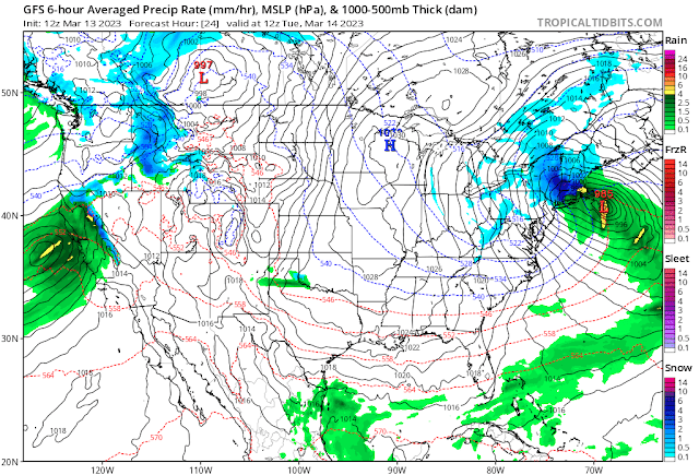
A jet stream firmly parked over the southern half of the United States will set the stage for the two major systems we'll have to deal with over the next couple of days.

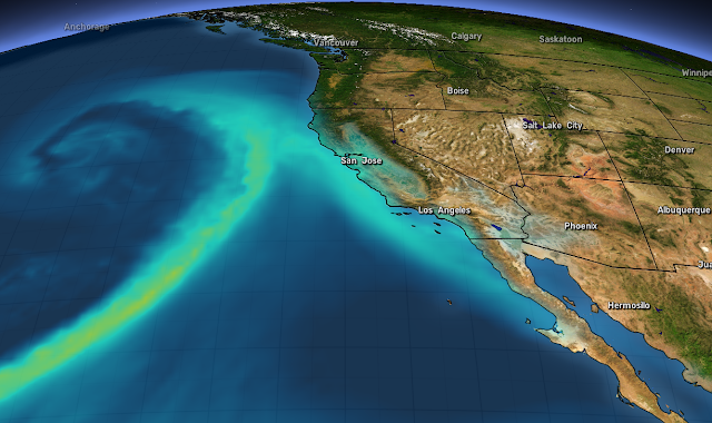
Out west, upper-level winds will funnel a rich plume of moisture straight into California. (Stop me if you've heard this one before.) This latest atmospheric river will fuel widespread heavy rains at lower elevations and very heavy snows for the Sierra Nevada.

Back east, the combined lift of a trough digging across Eastern Canada and that strong jet stream over the southeastern U.S. will lead to the rapid development of a low-pressure system off the Mid-Atlantic coast late Monday evening.

This low will spin itself up in a hurry, likely meeting the criteria for bombogenesis, or a "bomb cyclone" as you'll probably hear it termed. This just means that the storm's minimum pressure will deepen very quickly, leading to wicked winds and widespread heavy snowfall across much of New England.

More Flooding For California

A weather alerts map of California today looks like a toddler went at it with a fresh pack of Crayola and a vivid imagination. The state is blanketed with flood watches, wind advisories, high wind warnings, and winter storm warnings for the mountains.

Source: NWS

Wind gusts could reach 50 mph for much of the northern half of California through Wednesday, with gusts up to 70 mph possible along the coastline and elevations above 1,000 feet. Those winds could easily lead to downed trees and power outages, especially with soils soaked from all the rain over the past couple of weeks.

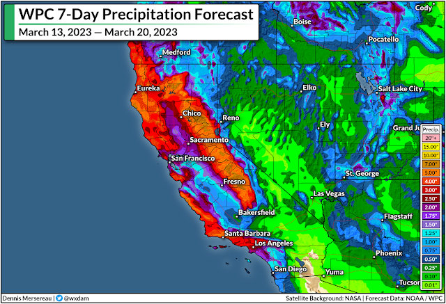
There's plenty more rain where that came from. The latest forecast from the Weather Prediction Center paints widespread rainfall totals of 3-5 inches along the coast, with up to 2.5 inches in the Central Valley and higher totals up north. Much of that precipitation in the mountains will fall as snow, with five feet of additional snow possible above 8,000 feet. 


This latest slug of rain and snow will add further stress to the region's waterways, many of which already spilled over their banks with the round of precipitation a few days ago.

As always, stay alert for flooding and be prepared to change your travel route if you come across a flooded road. It's impossible to tell how deep the water is until it's too late, and it only takes a few inches of moving water to lift a vehicle and carry it downstream. California's hilly terrain increases the odds that there may not even be a roadway left under the floodwaters.

Heavy Snow And High Winds For New England

Meanwhile, the East Coast will soon deal with a storm that could be its most significant thump (in fact, one of its only bouts) of wintry weather this year.

A classic nor'easter will spin up off the East Coast tonight and roar through early Wednesday morning, targeting much of New England with heavy snow and high winds for the day Tuesday.


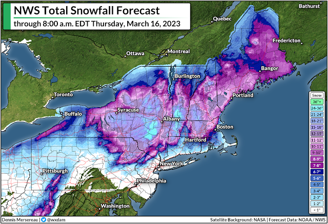
The storm will really get cranking early on Tuesday morning, plastering almost everyone from northeastern Pennsylvania to coastal Maine with double-digit snowfall totals by the time the storm is over on Wednesday.

Most of the snow will fall north and west of I-95, sparing Philly and New York from much more than a dusting at best. Higher elevations in upstate New York could see up to two feet of snow.

Boston is going to be right on the borderline between a nuisance and a solid storm, with about 6-8 inches of snow in the forecast right now—with much lower totals just east and much higher totals just west. It wouldn't take much of a nudge in the storm's ultimate track to push that fine line in either direction. I don't admire local meteorologists up there right now.

Strong winds of 50-60 mph are likely during the storm, which will lead to tree damage and power outages for many location. This is going to be a wet, sloppy snow, to boot, which will weigh down trees and power lines and make damage and outages even more likely. Coastal flooding is also possible.

Heavy snowfall rates and high winds will lead to reduced visibility during the height of the storm, with whiteout conditions possible at times. If you have to travel through the area, it'd be a good idea to get where you need to go by Monday night and plan to stay put for a couple of days. 

[Top Image: Tropical Tidbits]


You can follow me on Facebook, Mastodon, Twitter, Instagram, or send me an email.

Please consider subscribing to my Patreon. Your support helps me write engaging, hype-free weather coverage—no fretting over ad revenue, no chasing viral clicks. Just the weather.


January 4, 2023

California Flood Risk Ramps Up As Another Atmospheric River Washes Over West Coast


Widespread heavy rain, high winds, and many feet of mountain snows are on the way to California over the next couple of days as another powerful storm swirls off the coast.

This latest wash of heavy rain will lead to a heightened flood risk for much of coastal California, with many communities still cleaning up the damage from the prolific rains that fell over the weekend.

We're in the midst of an exceptionally unsettled stretch of weather across the West Coast as a series of potent low-pressure systems take aim at the region.

This week's atmospheric river will bring the risk for several inches of rain across a wide swath of coastal California. The Sierra Nevada will see very heavy snow, with areas above 5,000 feet piling up multiple feet of snow over the next few days.

Source: NWS/WPC

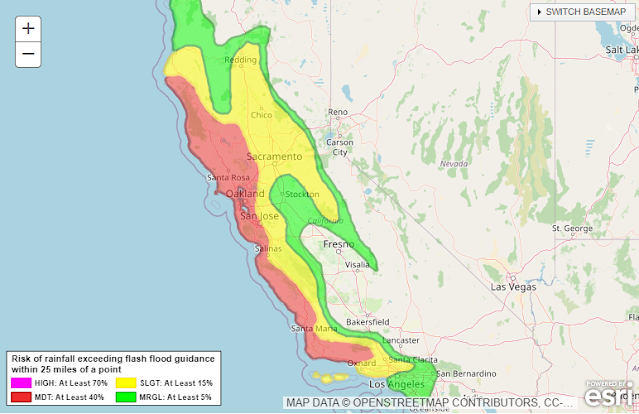
The Weather Prediction Center (WPC) issued a moderate risk for excessive rainfall for much of the day Wednesday. This means that there's at least a 40 percent chance of rain exceeding flash flood guidance, or rain falling fast enough to trigger flash flooding in certain areas. Moderate risks don't come around too often, so that's a strong sign that vulnerable areas will see dangerous conditions.

We'll see high winds accompany the heavy rainfall through Thursday. Much of California is plastered in high wind warnings as gusts will reach 40-60 mph in most areas. Higher elevations could see gusts up to 70 mph at times. Since the ground is soaked from recent and ongoing rains, the winds will likely lead to tree damage and power outages in spots.


It's not over once this storm moves along, either.

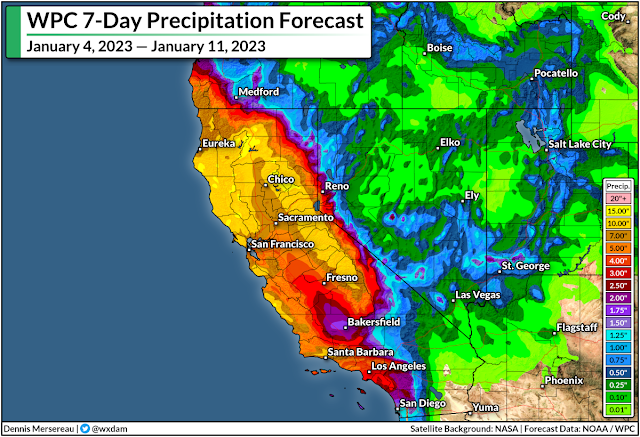
The WPC's latest precipitation outlook for the next seven days shows 10-15+ inches of rain falling on a huge swath of California through next week, with the heaviest precipitation focused on northern California and the mountains.

A continued train of storms will focus on California in the coming days, with about a day or two of spacing between each one. We're seeing this relentlessly wet pattern as a result of a powerful jet stream sagging pretty far down over the Pacific Ocean.

Source: Tropical Tidbits
This jet isn't moving very much, so it has the opportunity to pump out one storm after another as each trough breaks at the end of the jet like a wave crashing on the beach.

Additional strong systems could reach the coast by this weekend, early next week, and late next week.

Remain mindful of the dangers of flash flooding. It's impossible to tell how deep the water is until it's too late. It takes surprisingly little moving water to lift up a vehicle and carry it away. Most freshwater flooding deaths in the U.S. occur when people drive their vehicles into deep or moving waters. Sometimes, especially in a hilly state like California, the road may be completely washed out under the water.

If you're under a wind advisory or high wind warning, you're at risk for power outages. It'll take crews longer to restore power during bad weather.

Make sure you've got batteries and flashlights on hand so you can see in the dark without wasting your cell phone battery on the flashlight feature. Rechargeable cell phone battery packs are also a great investment—they're relatively cheap now and most can provide one or two boosts to a smartphone's charge.

[Top image created using WSV3]

You can follow me on Facebook, Mastodon, Twitter, Instagram, or send me an email.

Please consider subscribing to my Patreon. Your support helps me write engaging, hype-free weather coverage—no fretting over ad revenue, no chasing viral clicks. Just the weather.