March 3, 2025

Powerful spring storm threatens tornadoes, damaging winds this week


Widespread severe thunderstorms, winter weather, and damaging winds are likely over the next couple of days as a powerful low-pressure system develops across the center of the country. 

This storm could come close to breaking some monthly pressure records across the Midwest. Even if it falls just short, this intense Colorado low will run the table with just about every type of active weather through midweek. 

The Setup


SOURCE: Weather Prediction Center

A strong jet stream snaking across the middle of the United States is giving rise to a powerful low-pressure system over eastern Colorado. This system will steadily intensify as it makes its way toward the Great Lakes through Wednesday, dragging the entire spectrum of active weather along its path. 

This system's minimum central pressure could drop to around 980 mb by Wednesday, which is within a few millibars of the all-time March low air pressure records in places like Chicago. This is going to be a formidable storm—and its strength will reflect in the thunderstorms, winds, and wintry weather it produces.


Wind advisories and high wind warnings span much of the southern United States as this storm roars to life. These will be pressure gradient winds—simply winds kicked up by the low-pressure system's rapid intensification, independent of the thunderstorms expected across the region. 

Cold air on the northern side of the system will drop heavy snowfall across the Plains and Upper Midwest, with blizzard conditions expected through parts of eastern Colorado and western Nebraska.

The most pressing concern, though, is a dayslong risk for severe thunderstorms.

Monday's Severe Weather


An enhanced—level 3 out of 5—risk for severe weather exists across parts of the southern Plains on Monday night into early Tuesday morning.

Forecasters expect severe thunderstorms to develop across northern Texas and southern/central Oklahoma during the overnight hours. Storms may initially form as supercells before quickly congealing into a squall line. Tornadoes, damaging winds in excess of 60 mph, and large hail are all possible in these nocturnal thunderstorms.

Tuesday's Severe Weather


The risk for severe thunderstorms will peak on Tuesday as strong wind shear meets up with ample instability over the Deep South. 

Monday night's squall line will likely continue moving east toward the Mississippi River through the morning and afternoon hours on Tuesday, bringing the risk for damaging winds with embedded tornadoes.

Additional thunderstorms are possible ahead of that squall line. Any discrete thunderstorms that develop in this environment will be capable of producing strong tornadoes. The severe threat will continue as the squall line pushes through the region with the risk for damaging winds in excess of 70 mph. 

Wednesday's Severe Weather


Our squall line will keep on trucking toward the East Coast overnight Tuesday into early Wednesday, shoving the risk for severe weather east.

Thunderstorms may produce damaging wind gusts as far north as Buffalo, New York, and as far south as Orlando, Florida. The greatest risk for damaging winds—and possibly an embedded tornado or two—will exist from the D.C./Baltimore area south through the Carolinas and into eastern Georgia. 

NOTE: The forecasts referenced in this article were issued by the National Weather Service, a critical federal agency that's likely responsible for directly saving more lives than just about any other office in the government. The National Weather Service costs $3 per year per taxpayer.

Free and instant lifesaving warnings, Doppler radar data, satellite imagery, computer models, and realtime observations would likely vanish if this agency were gutted. Please contact your representatives to urge lawmakers to save NOAA and the National Weather Service from irreparable damage.


Follow me on Facebook | Bluesky | Instagram

Get in touch! Send me an email.

Please consider subscribing to my Patreon. Your support helps me write engaging, hype-free weather coverage—no fretting over ad revenue, no chasing viral clicks. Just the weather.


February 3, 2024

Flooding risk as atmospheric river fuels rainy, windy storm sweeping into California


A series of systems rolling through the eastern Pacific will wash ashore in California over the next couple of days, fueling a spell of foul weather across the state. 

Heavy rains are likely up and down the coast, with southern California facing the greatest risk for flooding and landslides. Prolific mountain snows are likely across higher elevations throughout the Sierra. Gusty winds are likely across the state early into the workweek, which may lead to tree damage and power outages.

A quick look at the pattern across the country this weekend almost looks like an image you'd see in the El Niño chapter of a meteorology textbook. A strong jet stream draped across the entire southern half of the U.S. is exactly what you'd expect to see during an El Niño winter.

A model image of the jet stream on Saturday afternoon. (Tropical Tidbits)

An upper-level trough digging into the West Coast will drive the active weather over the next couple of days. The most impactful conditions will arrive courtesy of a low-pressure system hitting the coast late Saturday through Sunday, though heavy rains will continue Monday and Tuesday across the southern half of the state.

Powerful southwesterly winds hauling tail into the California coast is dragging a plume of tropical moisture straight from Hawaii. This ribbon of elevated moisture—called an atmospheric river—will fuel the drenching rains we'll see across California over the next few days. Atmospheric rivers provide a vast reserve of moisture for storms to tap into to create excessive rainfall rates.

A model animation showing the atmospheric river moving into California through Tuesday, Feb. 6. (PolarWx/Tomer Burg)

Rain is already starting to come ashore in California on Saturday afternoon, and we'll see the rain increase in coverage and intensity through the overnight hours and into the day Sunday.

We'll see the rain slacken a bit for the northern half of the state as this initial system moves east. However, the heart of the atmospheric river will continue streaming over southern California through at least Tuesday, providing ample opportunity for bouts of heavy rain to continue throughout the area.

The Weather Prediction Center's latest forecast calls for 3-5 inches of rain for just about the entire California coast from San Diego all the way up to near Eureka. It's going to be a soggy couple of days for San Diego, Los Angeles, and San Francisco.


Higher terrain will enhance rainfall totals up and down the coast—especially along the Transverse Ranges, where 5-7 inches of rain is in the forecast with the potential for some areas to see locally higher rainfall totals.

Folks in the Central Valley will benefit (or suffer, depending on your point of view) from the rain shadow effect, with less than an inch of rain over the next week for communities like Bakersfield and Fresno.


As usual, a glut of torrential rain heading for California is a recipe for widespread flash flooding and landslides. The greatest risk for flooding exists across southern California.

The usual safety spiel is extra important this time around: Never attempt to drive across a flooded roadway. It's impossible to tell how deep the water is until it's too late, and California's rugged terrain makes it more likely that the road is washed-out beneath the water. 

Precipitation will fall as heavy snow across the Sierra above 3,000 feet. Freezing levels will rise to 4,000 to 6,000 feet as mild air flows inland with the surge of subtropical moisture. Several feet of snow and whiteout conditions are likely in areas expecting all snow, which will force some road closures through the mountains as the heavy, blowing snow will be extremely difficult or downright impossible.


Widespread gusty winds are likely as this initial storm rolls across the state Saturday night through Sunday. High wind warnings and wind advisories are in place for most of California. Gusts of 40+ mph are possible in areas under a wind advisory, while gusts of 60+ mph are expected for communities under high wind warnings.

The combination of strong winds and heavy rainfall will lead to a risk for tree damage and power outages. Avoid rooms where trees or tree limbs may fall through the walls or roof during high winds, and try not to park beneath trees if you can help it.

[Satellite image courtesy of NOAA]


Follow me on Facebook | Bluesky | Threads | Instagram | Twitter

Get in touch! Send me an email.

Please consider subscribing to my Patreon. Your support helps me write engaging, hype-free weather coverage—no fretting over ad revenue, no chasing viral clicks. Just the weather.


January 7, 2024

Significant early-week storm to bring flooding rains, widespread strong winds


A long-anticipated and high-impact storm is finally developing over the southern Rockies on Sunday as an impressive trough in the jet stream swoops over the United States. That trough (shown in the model image above) will fuel a powerful low-pressure system that'll roll from Texas toward the Great Lakes through the middle of the week. 

This storm is going to be a doozy for just about the entire eastern half of the country beginning Monday and lasting through Wednesday. Flooding rains, heavy snow, severe thunderstorms, and widespread gusty winds are all likely over the next couple of days. Expect airport delays and cancellations, tough road conditions in areas expecting snow, and disruptive flooding—especially across the Northeast.

The Setup

This is about as classic as it gets for a disruptive winter storm across a huge swath of the U.S. and Canada. A powerful trough swinging over the Rockies this weekend will give rise to a fast-strengthening low-pressure system over Texas late Sunday into Monday.

A model image showing above- or below-average moisture in the atmosphere through Wednesday evening. Green colors show higher-than-normal moisture drawn north by the storm. (Tropical Tidbits)

Our budding storm will track from Texas toward the Great Lakes over the next couple of days, reaching its peak strength on Tuesday and Wednesday as it taps into very strong upper-level winds throughout the region.

Conditions will vary greatly depending on which side of the storm you land on. The storm will carry a vast reserve of tropical moisture streaming in from the Gulf of Mexico, which will fuel heavy snow on the cold side of the system and impressive rains where warmer conditions prevail.

Strong Winds

Gusty winds are a given with any robust low-pressure system that covers a solid half of the country. This system will churn up the atmosphere in abundance through the middle of the week, allowing for widespread gusty winds along its path.
A model animation showing the probability of 40+ mph wind gusts between Monday and Wednesday. (Tomer Burg/PolarWx)

Wind advisories and high wind warnings are likely from the Gulf Coast all the way toward the Great Lakes and New England over the next few days as this storm revs up. 

The model image above (from Tomer Burg's incredible website PolarWx) shows the probability of 40+ mph wind gusts between Monday evening and Wednesday evening. Warmer colors indicate greater odds of gusty winds that could bring down trees and power lines, especially where soils are loosened by recent and ongoing heavy rains.

Falling trees are the greatest threat for injury during any wind event. Take note of trees or tree limbs that hang over your home or vehicle, taking care to stay away from those rooms and areas while gusty winds are blowing. 

Flooding Rains

Most of the East Coast will wind up on the warm side of this system. Tuesday should feel like a spring day across much of the east as temperatures and humidity levels climb toward something you'd expect in early April rather than early January.


A surge of moisture and the sheer amount of lift generated by this storm will combine to produce several inches of rain from Florida to Maine. Some of that precipitation will initially fall as snow in higher elevations and toward the Canadian border, but the vast majority of the east's precipitation will be liquid rain.

Standing water on roads and rising waterways will be a concern throughout the area, but the greatest risk for flooding will develop across areas of the Northeast that saw a thump of accumulating snow this weekend. Heavy rain falling on snowpack is bad news all around.

Snow prevents the runoff from readily absorbing into the ground. The risk for roof collapses will increase amid the weight of water-laden snow. Storm drains clogged by mounds of snow will enhance street and parking lot flooding, and water pooling against foundations could lead to water intrusion into homes and businesses.

Severe Thunderstorms

Strong wind shear, unstable air, and plenty of moisture will fuel a risk for severe thunderstorms along the northern Gulf Coast on Monday and throughout Florida and the southeastern coast on Tuesday.


The greatest threat with these storms will be damaging wind gusts, but a few tornadoes are likely, and there's a non-zero chance that a tornado or two could be on the stronger side—especially if any individual thunderstorms can engage with the wind shear present over the region.

Even though it's a yearly tradition, so to speak, winter severe weather threats are dangerous because many folks don't expect to duck from a tornado early January. If you're under the threat for severe weather this week, check your cell phone and make sure emergency alerts are switched on for tornado warnings.

Heavy Snow

Folks on the colder northern side of the storm will see plenty of snow through the middle of the week. The swath of heavy snow will be relatively narrow, making these totals dependent on the precise track of the storm as it swings through the region.


Right now, the National Weather Service has a swath of shovelable snow from Kansas into northern Michigan, with more than 6 inches of snow likely throughout northern Missouri, eastern Iowa, northwestern Illinois, and southern Wisconsin. Gusty winds will make travel difficult during bouts of heavy snowfall. 

Conditions for everyone affected by this storm will improve rapidly late Tuesday into Wednesday as the storm hustles into Eastern Canada. We'll have a little while to catch our breaths before another formidable storm develops and threatens many of the same areas Friday into next weekend.

[Top image shows the big trough sparking our storm, via the SPC]


Follow me on Facebook | Bluesky | Threads | Instagram | Twitter

Get in touch! Send me an email.

Please consider subscribing to my Patreon. Your support helps me write engaging, hype-free weather coverage—no fretting over ad revenue, no chasing viral clicks. Just the weather.


December 16, 2023

Weekend deja vu as second powerful East Coast storm hits Sunday and Monday


Didn't we go through this last weekend?

A(nother) powerful storm developing near Florida will roll up the length of the East Coast beginning Saturday night and lasting into Monday, producing a large swath of heavy rains and very strong winds.

The worst conditions will occur at the coast where communities—especially the N.C. Outer Banks—may experience significant storm surge flooding.

Our storm is developing today in the eastern Gulf of Mexico as a steep trough digs over the eastern U.S. This low will strengthen in a hurry as it taps into strong upper-level winds and parallels the southeastern coast.

We'll see the storm move from Florida through Georgia and into the Carolinas on Sunday, bringing widespread heavy rains and very strong winds. Gusts of 50+ mph are likely at the coast, with gusts of 30-40+ mph reaching inland all the way to the mountains.


The low-pressure system will quickly track into the Northeast by Sunday night, heading into Atlantic Canada by Monday.

A deep plume of tropical moisture sourced from the Caribbean will draw into the system as it revs up, allowing for torrential downpours along its path. Widespread rainfall totals of 2-3 inches are likely from Florida to Maine, with locally higher totals possible. This could easily lead to flash flooding in some areas.

In addition to the potential for bad coastal flooding, the combination of strong, persistent winds and heavy rainfall will lead to a risk for power outages along the storm's track. There's also a high chance that we'll deal with flying Santas over the next couple of days. Secure or bring inside all of your outdoor Christmas decorations. Inflatables are notorious for getting loose in high winds. Any decorations or furniture that tumbles down the road could cause injuries, damage, or even car crashes.


This is an...unusual...storm in that we're not really expecting any snow—at least not initially. Temperatures are too warm for anyone on the East Coast to see frozen precipitation as the storm swings through the region. It is the middle of December. That isn't normal. (But nothing really is anymore.)

Cold air wrapping in behind the system will allow for lake-effect snow to develop across the Great Lakes, so a dose of snow in the usual areas is likely to begin the week. This cold air will reach all the way to the coast in northwest flow behind the storm, making for a pretty chilly Tuesday before temperatures turn mild again as the week wears on.

[Top image via Tropical Tidbits, showing modeled surface winds on Sunday evening.]


Follow me on Facebook | Bluesky | Threads | Instagram | Twitter

Get in touch! Send me an email.

Please consider subscribing to my Patreon. Your support helps me write engaging, hype-free weather coverage—no fretting over ad revenue, no chasing viral clicks. Just the weather.


December 9, 2023

East Coast in for a pressure washing as a powerful storm arrives Sunday


A feisty low-pressure system is gearing up to bring plenty of disruptive weather to the East Coast over the next couple of days. Widespread heavy rain could lead to flooding along the I-95 megalopolis while the storm produces snow near the Great Lakes and severe storms across the southeast.

Sunday/Monday's storm is part of a dynamic pattern that's gradually making its way across the eastern half of the country. A cold front extending off a low-pressure system moving through the Great Lakes is responsible for most of the active weather we're seeing on Saturday. A new storm will develop along this front on Sunday, becoming the dominant system that'll bring all the headaches to end the weekend.


Sharp wind shear through the atmosphere combined with a cold front running into a pool of warm, moist air is a recipe for severe thunderstorms. An expansive severe risk covers a chunk of the southern U.S. on Saturday, mainly focused on the lower Mississippi Valley east into Alabama and Tennessee.

Any severe thunderstorms that bubble up on Saturday could produce damaging winds, hail, and a few tornadoes. We already saw a couple of tornadoes touch down in north-central Tennessee early Saturday afternoon.


We'll see that storm threat shift east on Sunday as the cold front heads toward the Atlantic coast. Severe thunderstorms are possible from the D.C./Baltimore region down the I-95/I-85 corridor toward southeastern Alabama and the northern half of Florida. The main risk with Sunday's storms would be damaging wind gusts, but a few tornadoes are possible, especially in parts of eastern Virginia and North Carolina.

Farther north, this developing storm's main threats will be drenching rains, heavy snow, and blustery conditions.

Flood watches span the I-95 corridor from D.C. to Portland as forecasters anticipate several inches of rain falling through the day Sunday. Lots of rain falling in short order can overwhelm waterways and drainage systems, leading to pooling and possible street flooding.


It's not going to be a gentle downpour, either. Widespread wind gusts of 20-30+ mph will accompany the storm as it chugs through interior New England on Sunday. Much stronger winds are likely for coastal communities across the northeast, where a period of 50-60+ mph wind gusts will be possible into Monday.

Winds this strong combined with wet soils could lead to fallen trees and power lines. Make sure your holiday decorations are tied down or brought inside, as well. Those things will take flight in a hurry once the gusty winds start, and it could be dangerous if they blow into the road.

Cold air flooding in behind the system will allow for widespread snow across the Northeast interior and down the spine of the Appalachians. The heaviest totals are likely near the Canadian border, where higher elevations in New York and Vermont could see more than a foot of fresh snow by Monday.


If you have plans to travel late Sunday or early Monday, it's worth keeping in mind that some models are struggling a bit with the potential changeover from rain to snow across parts of Pennsylvania, the Mid-Atlantic, and even down into the North Carolina Piedmont.

Plan ahead for the potential for a burst of snow during the last few hours of precipitation overnight Sunday into Monday, with possible accumulation if temperatures are cold enough.

[Top model image generated using WSV3]


Follow me on Facebook | Bluesky | Threads | Instagram | Twitter

Get in touch! Send me an email.

Please consider subscribing to my Patreon. Your support helps me write engaging, hype-free weather coverage—no fretting over ad revenue, no chasing viral clicks. Just the weather.


May 15, 2022

Damaging Wind, Tornado Risk Targets East Coast States On Monday


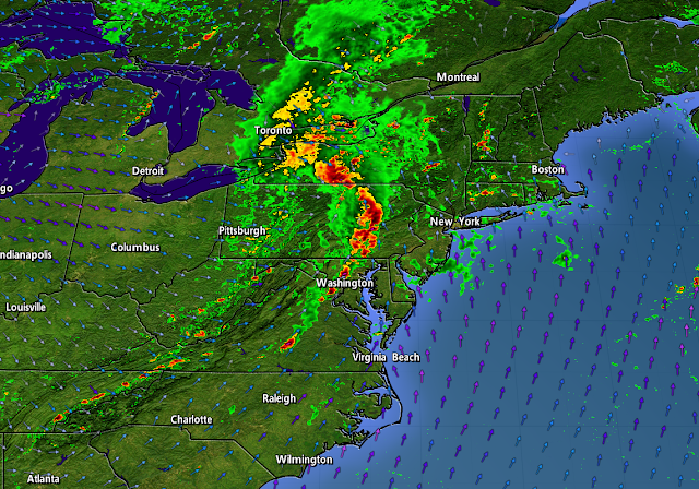
A widespread threat for severe thunderstorms will cover much of the East Coast on Monday as a cold front plows into the heat and humidity that's parked over the region in recent days. The storms could bring damaging wind gusts, a few tornadoes, and some instances of large hail. Make sure you've got a way to receive warnings the moment they're issued.

A trough swinging over the Great Lakes will allow a low-pressure system to develop across eastern Ontario and southern Quebec during the day on Monday. A cold front extending off this budding low will set the stage for a broken line of thunderstorms to sweep across the eastern states.


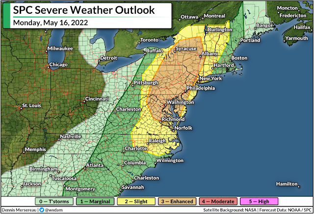
There's enough instability and wind shear for these thunderstorms to turn severe. The Storm Prediction Center issued a wide-ranging risk for severe weather on Monday, covering everyone from southern Georgia to interior Maine.

The greatest risk for severe weather—an enhanced risk, or a three out of five on the scale—will stretch from central Virginia to northern New York, including the metro areas of Washington, Baltimore, Philly, Syracuse, and Albany. The severe risk extends west to the mountains and east to include the entire I-95 corridor from Savannah up to Portland.


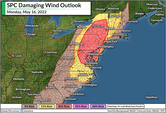
For most folks, the risk for damaging wind gusts of 60+ mph will be the predominant threat. However, folks in and around the enhanced (orange) and slight (yellow) risk zones could see a few spin-up tornadoes along the leading edge of any squall lines that move through.

Keep an eye out for alerts and prepare to act quickly if your location goes under a tornado warning. Take a second to check your phone and make sure emergency alerts are activated for tornado warnings.


It's worth pointing out for our friends up north that the threat for damaging winds and a tornado or two will extend into portions of eastern Ontario and southern Quebec, as well. This risk includes the National Capital Region, Montreal, and the Eastern Townships on Sunday afternoon and evening.

Conditions will calm down behind the front. Folks in the northeast will see a couple of days of cooler-than-normal temperatures before the heat starts to build back in toward the end of the week. Folks south of the Mason-Dixon line are looking forward to daytime highs in the 90s beginning Wednesday and lasting into the weekend.

[Top image created using WSV3]


You can follow me on Twitter or send me an email.

Please consider subscribing to my Patreon. Your support helps me write engaging, hype-free weather coverage—no fretting over ad revenue, no chasing viral clicks. Just the weather.


February 16, 2022

A Major System Will Close Out The Week With Gusty Winds, Snow, Ice, And Severe Storms


It's been a little while since we've had noteworthy active weather across the United States. A steep trough in the jet stream will spawn a potent low-pressure system over the Plains on Wednesday, setting the stage for a widespread risk for severe thunderstorms in the south while snow and ice coat communities from Kansas to Michigan.

The Setup

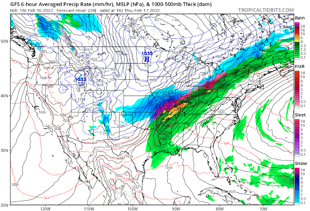
SOURCE: WPC

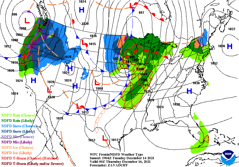
That's one messy map.

A robust low-pressure system will develop on the southern Plains early Thursday morning. The system will get its act together in a hurry, speeding across the Midwest toward the Great Lakes before reaching New England during the day on Friday.

We're going to see a little bit of everything with this storm, with heavy rain and severe thunderstorms to the south to a threat for snow and ice to the north.

The Wind Threat

The most widespread issue with this system will be strong, gusty winds.


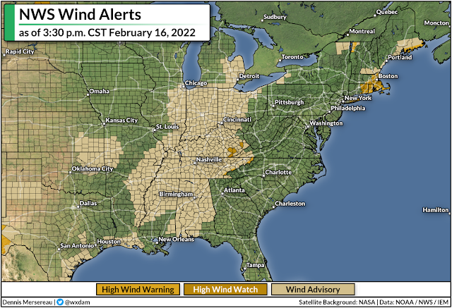
Wind advisories and high wind warnings are in effect for a large swath of the country from Alabama to Michigan, and it's likely that these alerts will spread east over the next couple of days.

The system will spread gusty winds across much of the eastern United States through Friday. Wind gusts of 35-45 mph will be common, with much higher gusts in some spots. The greatest potential for damaging winds exists near the eastern Great Lakes. Downed trees and power outages are likely in areas that catch the strongest gusts. 

The Severe Threat

Here's something we haven't had to deal with in a while, and it's directly related to those gusty winds.


Warm(ish), humid air on the southern side of the low-pressure system could fuel several days of severe thunderstorms across the south, beginning with the southern Plains on Wednesday.

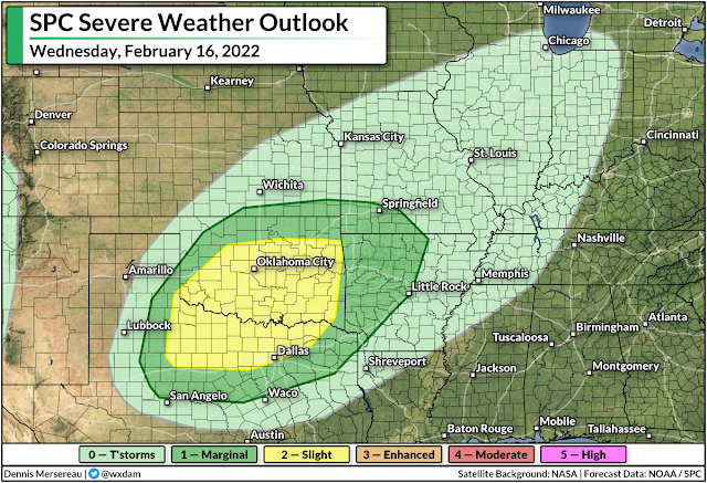
A slight risk for severe weather is up for parts of Texas, Oklahoma, and Arkansas on Wednesday. All modes of severe weather are possible here, including a threat for tornadoes across northern Texas and southern/eastern Oklahoma.


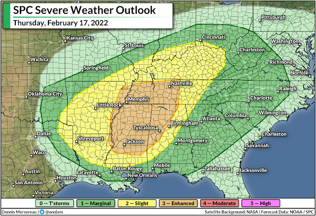
The storm threat will shift east on Thursday as the low pulls toward the Great Lakes. Severe thunderstorms could develop along and ahead of the cold front as it sweeps through the southeastern states. This is the first risk for severe weather we've seen in some areas, especially in the Carolinas, since last year.

The greatest threat from these storms will be damaging wind gusts. We'll see gusty winds with or without thunderstorms—it won't take much of a downdraft for a thunderstorm to shove even higher winds down to the surface, hence the widespread severe risk through Friday morning. 

A significant portion of Thursday's severe weather risk will unfold overnight Thursday into Friday. Nighttime severe weather is especially dangerous because it's easy to miss warnings after you've tuned out or you've gone to bed.

Take a moment today to check your cell phone and ensure that wireless emergency alerts are activated for tornado warnings. It's easy to switch all the alerts off after one ill-timed activation for an AMBER Alert, but those tornado warnings are proven lifesavers and can catch your attention when you're focused on anything but the weather.

It's also worth noting that the widespread heavy rain and thunderstorms could lead to a risk for flooding along and near the track of the low itself. Flood watches are in effect from southern Missouri to western New York, with several inches of rain expected for most areas. That typically wouldn't be a problem on its own, but the rain on top of snowmelt will lead to localized flooding issues, and ice jams could lead to swollen streams and rivers overflowing their banks.

The Snow/Ice Threat

Cold air to the north of the low will allow precipitation to fall as snow and ice, especially in the Midwest and around the Great Lakes. This won't be a widespread winter storm like the storm we saw a few weeks ago, but the quick thump of snow and ice could cause issues in some areas.


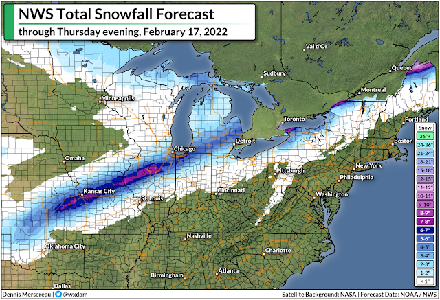
The National Weather Service's latest forecast calls for a narrow but potent swath of snow to fall from northern Oklahoma to northern Maine. The heaviest snow is likely across parts of Kansas, Missouri, and central Illinois, including the Kansas City metro area. We could see more than half a foot of snow across these areas. Several inches of snow could fall on the Chicago and Detroit metro areas, as well.

SOURCE: digital.weather.gov

As we often see around this time of year, warm air nudging in above the cold air at the surface will force some of the wintry precipitation to fall as freezing rain. We could see a light coating of ice along and north of the storm's track, with the heaviest totals possible in central Illinois and small parts of western New York and northern Maine.

This shouldn't be a debilitating ice storm by any means, but a glaze to one-tenth of an inch of ice accretion is enough to make travel dangerous and potentially bring down any weak tree limbs. The combination of the weight of the ice and gusty winds could lead to power outages.

[Model Graphic via Tropical Tidbits]


You can follow me on Twitter or send me an email.

Please consider subscribing to my Patreon. Your support helps me write engaging, hype-free weather coverage—no fretting over ad revenue, no chasing viral clicks. Just the weather.
 

December 14, 2021

A Quick-Hitting Storm Will Pack A Wallop With Destructive Winds, Severe Storms


A quick-hitting Colorado low will sweep over the central United States through Thursday and make a mess of things in its wake. The system will have it all: rain, snow, high winds, an extreme fire danger, and a risk for severe thunderstorms over parts of Iowa and Minnesota. 

Blink and you'll miss it. This storm is going to haul tail toward Canada, forming over Colorado on Wednesday morning and zoom into northern Ontario by the same time on Thursday morning. It's going to be quite the active 24 hours for a vast swath of the central United States, beginning with the threat for high winds and an extreme fire danger on the Plains.

Powerful Winds Likely on Wednesday


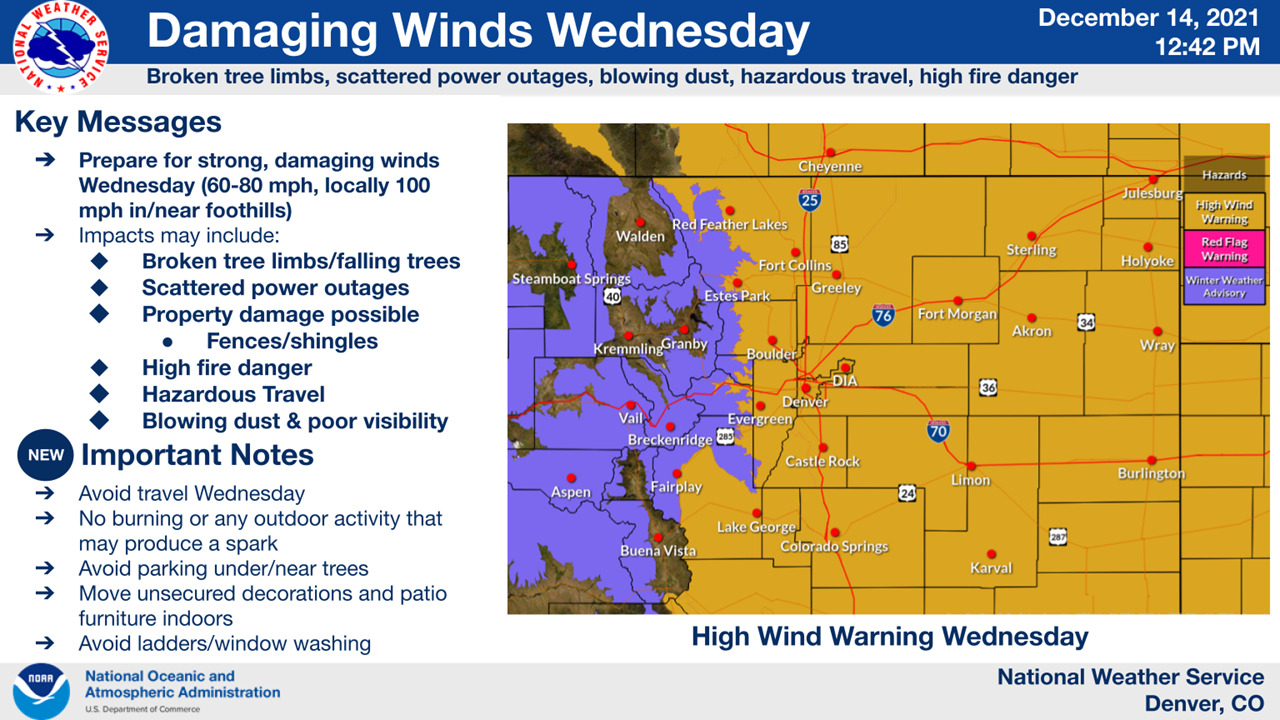
A dangerous situation is setting up along the path of the low from the Front Range straight through to the Great Lakes. Intense winds will easily mix down to the surface, bringing the threat for 60+ mph gusts that will topple trees, cause power outages, and toss around loose objects like Christmas decorations, patio furniture, trash cans, and grills.

The strongest winds will rake over the Front Range, where wind gusts could reach 100 mph in spots during the day on Wednesday. This is the graphic that NWS Denver made for the event, highlighting how dangerous conditions will be on Wednesday:


If the forecasts hold up, this will be a significant and memorable wind event for many folks in Colorado.

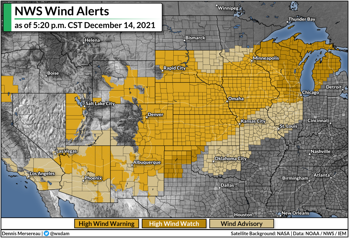
Strong winds will follow the path of the low as it races toward Canada. High wind watches and warnings are in place across the central Plains, a huge swath of the Midwest, and much of the Great Lakes in anticipation of damaging winds.

The criteria for wind advisories and high wind warnings varies from place to place, but it's safe to say that all of these regions will experience dangerous winds for a time on Wednesday and Thursday.

If you live in an area expecting powerful winds, remain mindful of tall trees or large tree limbs that loom over your home. Most wind-related injuries occur when trees or tree limbs fall into houses. If you have a big limb hanging over your bedroom, for example, consider avoiding that room as much as possible during the strong winds.

Prepare tonight for power outages tomorrow. Make sure your devices are charged and you have juiced-up flashlights within easy reach. (It's tough to feel around for flashlights batteries in the dark. Don't ask me how I know.)

High Fire Danger Accompanies The Winds

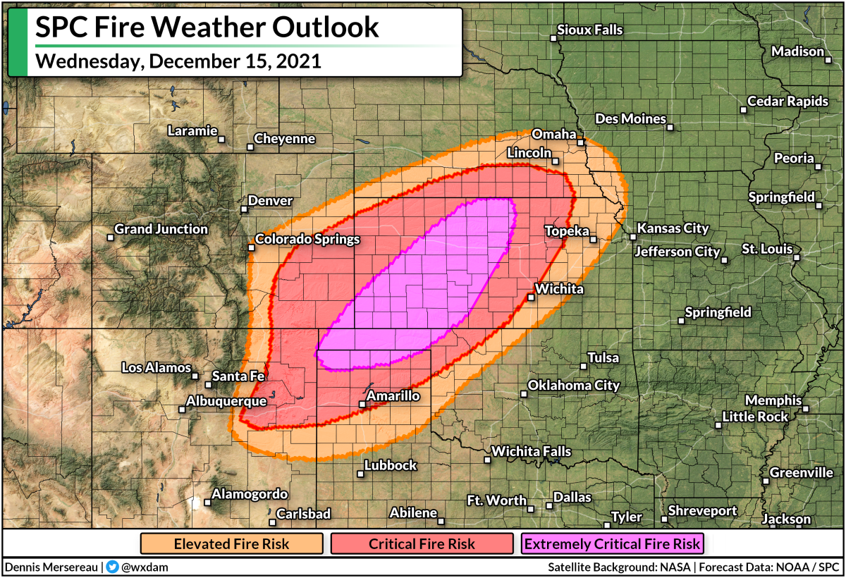
Powerful winds, warm temperatures, dry air, and ongoing drought conditions will all work together to create a high fire danger from the northern Texas Panhandle through central Kansas on Wednesday.


A high fire danger extends out to include communities from northeastern New Mexico to southern Nebraska. There aren't too many people who live in the affected areas, and I doubt many of you live there (thanks for reading if you do!), but it's the kind of day where any fire could quickly spiral out of control. One fire threatening one home is too many.

Severe Storms

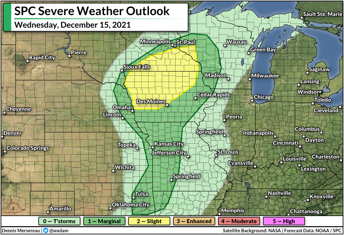
The surge of moisture and warmer, unstable air on the south side of the low will set the stage for thunderstorms to develop over Iowa and Minnesota on Wednesday.


The Storm Prediction Center issued a slight risk for severe weather across much of Iowa and southern Minnesota. The strongest storms that form in and around this area could produce tornadoes, damaging winds, and large hail. It won't take much of a downdraft to pull those intense winds down to the surface.

As always, make sure that you have a way to receive severe weather warnings the moment they're issued. Take a moment to look at your phone and ensure that emergency alerts for tornado warnings are active, and that you have a way to hear warnings if you're asleep when rough weather moves through.

It's also worth noting that much of the area under that severe weather risk on Wednesday currently has several inches of snow on the ground. It's not out of the realm of possibility that we could get a picture or two of a tornado traversing a snow-covered landscape. (It's not unprecedented!)


You can follow me on Twitter or send me an email.

Please consider subscribing to my Patreon. Your support helps me write engaging, hype-free weather coverage—no fretting over ad revenue, no chasing viral clicks. Just the weather.
 

April 29, 2021

Strong Winds Will Blow Across The Mid-Atlantic And Northeast On Friday


Who doesn't love a good windstorm? (Most people, it turns out.) High winds are likely on Friday as a cold front pushes across the East Coast, prompting wind alerts from the southern Appalachians to northern New England. Some communities could see wind gusts of 50-60 MPH on Friday afternoon and evening, which could be enough to bring down trees and cause power outages.
A low-pressure system over New England will move east over the Atlantic Ocean overnight Thursday into Friday. A center of high pressure will build in over the Great Lakes behind the front, and the strong pressure gradient between the high over the lakes and the low over the ocean will lead to blustery conditions across the region.

Modeled winds at the 850 mb level of the atmosphere on Friday evening. SOURCE: Tropical Tidbits

Winds in the lower levels of the atmosphere (around 5,000 feet or so) will crank up as they blow over the Northeast and Mid-Atlantic on Friday afternoon. Daytime heating causes the atmosphere to overturn as warm air rises and cool air descends to take its place. This churning motion—called "mixing"—can nudge some of those fast winds down to the surface, leading to the potential for strong wind gusts that could down trees and power lines.

A high wind warning is in place for parts of the Mid-Atlantic covering Delaware, much of New Jersey, central Maryland, and southeastern Pennsylvania, including Baltimore, Wilmington, and Philadelphia. These areas could see wind gusts as high as 60 MPH when the winds peak late on Friday. Wind advisories are in effect for the potential for 40-50 MPH wind gusts from New England on down the spine of the Appalachians.

Flights to, from, or over the Mid-Atlantic and Northeast could experience severe turbulence at times thanks to the strong winds, a point worth keeping in the back of your mind if you're flying somewhere on Friday.


Dry air behind the front will lead to an increased fire risk for some areas. The Storm Prediction Center's fire weather outlook issued on Thursday afternoon paints an elevated risk for fire weather conditions in parts of eastern North Carolina and Virginia, but local NWS offices issued fire weather watches for a much wider area that extends west to include upstate South Carolina and the Piedmont in North Carolina and Virginia. (The SPC fire weather outlook will update again in the very early morning hours on Friday.)

Gusty winds (and the associated wildfire risk) will wane overnight Friday into Saturday as the low pulls away from the Canadian Maritimes and the pressure gradient weakens. 


You can follow me on Twitter or send me an email.

Please consider subscribing to my Patreon. Your support helps me write engaging, hype-free weather coverage—no fretting over ad revenue, no chasing viral clicks. Just the weather.