Significant early-week storm to bring flooding rains, widespread strong winds

A long-anticipated and high-impact storm is finally developing over the southern Rockies on Sunday as an impressive trough in the jet stream swoops over the United States. That trough (shown in the model image above) will fuel a powerful low-pressure system that’ll roll from Texas toward the Great Lakes through the middle of the week.
This storm is going to be a doozy for just about the entire eastern half of the country beginning Monday and lasting through Wednesday. Flooding rains, heavy snow, severe thunderstorms, and widespread gusty winds are all likely over the next couple of days. Expect airport delays and cancellations, tough road conditions in areas expecting snow, and disruptive flooding—especially across the Northeast.
The Setup
This is about as classic as it gets for a disruptive winter storm across a huge swath of the U.S. and Canada. A powerful trough swinging over the Rockies this weekend will give rise to a fast-strengthening low-pressure system over Texas late Sunday into Monday.
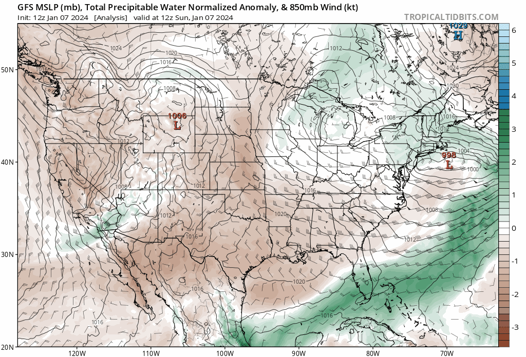 |
| A model image showing above- or below-average moisture in the atmosphere through Wednesday evening. Green colors show higher-than-normal moisture drawn north by the storm. (Tropical Tidbits) |
Our budding storm will track from Texas toward the Great Lakes over the next couple of days, reaching its peak strength on Tuesday and Wednesday as it taps into very strong upper-level winds throughout the region.
Conditions will vary greatly depending on which side of the storm you land on. The storm will carry a vast reserve of tropical moisture streaming in from the Gulf of Mexico, which will fuel heavy snow on the cold side of the system and impressive rains where warmer conditions prevail.
Strong Winds
Gusty winds are a given with any robust low-pressure system that covers a solid half of the country. This system will churn up the atmosphere in abundance through the middle of the week, allowing for widespread gusty winds along its path.
 |
| A model animation showing the probability of 40+ mph wind gusts between Monday and Wednesday. (Tomer Burg/PolarWx) |
Wind advisories and high wind warnings are likely from the Gulf Coast all the way toward the Great Lakes and New England over the next few days as this storm revs up.
The model image above (from Tomer Burg’s incredible website PolarWx) shows the probability of 40+ mph wind gusts between Monday evening and Wednesday evening. Warmer colors indicate greater odds of gusty winds that could bring down trees and power lines, especially where soils are loosened by recent and ongoing heavy rains.
Falling trees are the greatest threat for injury during any wind event. Take note of trees or tree limbs that hang over your home or vehicle, taking care to stay away from those rooms and areas while gusty winds are blowing.
Flooding Rains
Most of the East Coast will wind up on the warm side of this system. Tuesday should feel like a spring day across much of the east as temperatures and humidity levels climb toward something you’d expect in early April rather than early January.

A surge of moisture and the sheer amount of lift generated by this storm will combine to produce several inches of rain from Florida to Maine. Some of that precipitation will initially fall as snow in higher elevations and toward the Canadian border, but the vast majority of the east’s precipitation will be liquid rain.
Standing water on roads and rising waterways will be a concern throughout the area, but the greatest risk for flooding will develop across areas of the Northeast that saw a thump of accumulating snow this weekend. Heavy rain falling on snowpack is bad news all around.
Snow prevents the runoff from readily absorbing into the ground. The risk for roof collapses will increase amid the weight of water-laden snow. Storm drains clogged by mounds of snow will enhance street and parking lot flooding, and water pooling against foundations could lead to water intrusion into homes and businesses.
Severe Thunderstorms
Strong wind shear, unstable air, and plenty of moisture will fuel a risk for severe thunderstorms along the northern Gulf Coast on Monday and throughout Florida and the southeastern coast on Tuesday.

The greatest threat with these storms will be damaging wind gusts, but a few tornadoes are likely, and there’s a non-zero chance that a tornado or two could be on the stronger side—especially if any individual thunderstorms can engage with the wind shear present over the region.
Even though it’s a yearly tradition, so to speak, winter severe weather threats are dangerous because many folks don’t expect to duck from a tornado early January. If you’re under the threat for severe weather this week, check your cell phone and make sure emergency alerts are switched on for tornado warnings.
Heavy Snow
Folks on the colder northern side of the storm will see plenty of snow through the middle of the week. The swath of heavy snow will be relatively narrow, making these totals dependent on the precise track of the storm as it swings through the region.

Right now, the National Weather Service has a swath of shovelable snow from Kansas into northern Michigan, with more than 6 inches of snow likely throughout northern Missouri, eastern Iowa, northwestern Illinois, and southern Wisconsin. Gusty winds will make travel difficult during bouts of heavy snowfall.
Conditions for everyone affected by this storm will improve rapidly late Tuesday into Wednesday as the storm hustles into Eastern Canada. We’ll have a little while to catch our breaths before another formidable storm develops and threatens many of the same areas Friday into next weekend.
[Top image shows the big trough sparking our storm, via the SPC]


