July 25, 2023

Highs in the 90s to cover most of the East Coast this week, 100°F possible near D.C.


It's been an exceptionally hot summer for vast swaths of the United States so far, with a slew of longstanding records shattered in the desert southwest and unforgiving stretches of high heat and humidity in the southern states.

The heat will extend toward the Atlantic and park over the eastern states heading into the final weekend of July. Highs in the 90s will stretch far into New England, with daytime temperatures likely cracking the triple-digit mark in Virginia and Maryland.

- - - - -

Calling temperatures in the desert southwest "exceptionally hot" almost feels like an understatement given what they've been through for the past month.


Phoenix continues to pad its record-smashing streak of daytime highs reaching 110°F or hotter, with July 25 coming in as their twenty-sixth day of 110-degree-or-hotter heat. Tuesday's high in Phoenix climbed to 118°F.

The National Weather Service expects Phoenix's high to meet or exceed 110°F through Saturday before the potential 30-day streak has a chance to finally end on Sunday. 

El Paso, Texas, also continues to pad its own streak of consecutive days with a triple-digit high temperature. Tuesday was the city's 40th day with a high of 100°F or hotter, and the NWS expects it won't be until Sunday or Monday that El Paso has the opportunity to 'cool down' and break their historic run with a high of only 98°F or 99°F. 


This heat hasn't just stayed in the southwestern corner of the country. We've seen brutal heat build across the southern states and the Plains over the past couple of weeks. The Oklahoma Mesonet likely recorded its all-time highest heat index on July 13 with a 126°F heat index south of Oklahoma City.

The heat index combines the air temperature and the dew point to calculate how hot it feels to your body. A heat index of 126°F is pretty close to the upper end of what the human body can endure for any length of time.


And now it's the East Coast's turn to deal with the heat.

The intense ridge of high pressure parked over the southwest expanded east this week, pushing heat deep into the Plains and Midwest. Heat advisories are up for vast swaths of the central part of the country as triple-digit highs are likely this week as far north as South Dakota and Minnesota. 

A separate ridge will build over the western Atlantic and the East Coast for the second half of the week, the strength of which will crank up the heat for the eastern half of the country while forcing that desert heat dome to weaken a bit. This give-and-take is the driving force behind forecasters finally seeing an end to those historic runs of extreme heat in places like Phoenix and El Paso.

As the ridge strengthens, daytime highs will climb into the upper 80s and 90s for several days beginning Wednesday and lasting into the weekend for some areas.


Friday looks to feature the worst of the heat, when highs will climb well into the 90s along pretty much the entire eastern seaboard. Only folks at higher elevations or right on the water will be spared from the full intensity of the high heat.

Most communities along the megalopolis will reach the upper 90s on Friday, with heat indices soaring past 100°F when you factor in the humidity. It's possible that Baltimore and maybe D.C. could crack triple-digits for a little while on Friday afternoon.

Thankfully, this won't be an extended heat wave, but several days of hot daytime highs with muggy nights will make conditions extremely uncomfortable for folks who live without access to air conditioning or who work outside for long periods of time.

It's not just vulnerable people who are exposed to heat-related illnesses. Heat exhaustion and heat stroke can set in quickly with this kind of heat, even in folks who are physically fit, as those who exercise or work outside regularly tend to underestimate the heat and overdo it thinking they'll be fine.

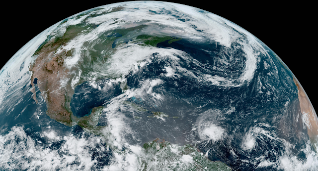
[Top image via Tropical Tidbits]


You can follow me on Facebook, Bluesky, Twitter, Instagram, or send me an email.

Please consider subscribing to my Patreon. Your support helps me write engaging, hype-free weather coverage—no fretting over ad revenue, no chasing viral clicks. Just the weather.


July 14, 2023

Records shattered as historic heat continues gripping desert southwest


The southwestern United States is firmly in the grips of a historic heat wave that's bringing the region not only some of their most extreme temperatures on record, but some of the highest heat the weather is capable of producing.

The National Weather Service office in Phoenix, Arizona, didn't mince words last Friday.

We are still anticipating this current heat wave to continue through next week and likely beyond with it rivaling some of the worst heat waves this area has ever seen.

[...] this should go down as one of the longest, if not the longest duration heat wave this area has ever seen.
That's no small feat coming from a part of the country where the average high temperature in July soars above the century mark.

Unfortunately, the dire predictions are panning out as we head into the weekend.

A near-record ridge of high pressure parked over the region is cranking the heat far above normal levels. Ridges of high pressure foster sinking air, which warms up and dries out as it sinks toward the ground. The result is a terrible streak of very high temperatures that's approaching the upper bounds of what we've ever measured in the desert southwest.


El Paso, Texas, is in the midst of its longest streak of triple-digit days on record. As of Friday, July 13, the city has seen 29 consecutive days with a high temperature of 100°F or hotter, shattering the previous record of 23 days set back in July 1994. The record will keep on growing through next week.

Phoenix, Arizona, tied its second-hottest low temperature on record on Thursday when the city's temperature bottomed out at 95°F early in the morning. Friday marked their 15th consecutive day with a high temperature of 110°F or hotter, and they'll easily beat their all-time record of 18 days with supercentenarian highs by early next week.  


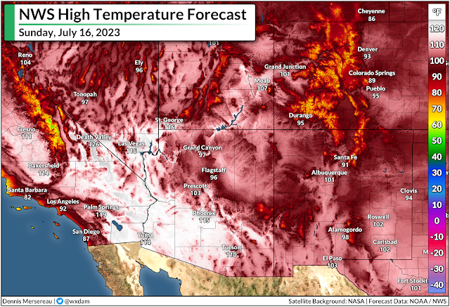
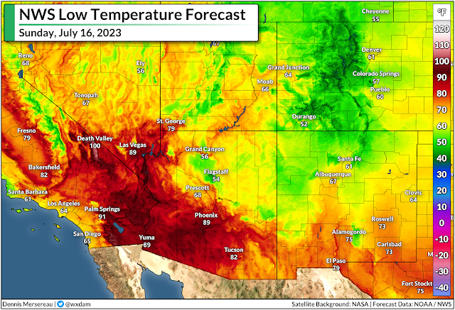
The low temperature in Death Valley, California, will only dip to a cool 100°F on Sunday morning.

The world's deadliest weather disaster isn't hurricanes, or tornadoes, or floods—it's extreme heat. Brushing off excessively high temperatures is easy and tempting from an air conditioned office, but consider how many people here at home and around the world lack simple things like air conditioning or clean water.

I wrote about the phenomenon of folks brushing off extreme heat a few years ago:

It's called survivorship bias. Lots and lots of people died before air conditioning as a direct result of not having air conditioning.

It's sort of like the folks who scream "why do we need to coddle kids with all these safety features, I grew up just fine!" Sure, you may have turned out okay! But cemeteries are too full of too many little kids who, it turns out, couldn't get by without car seats or vaccines or wall-fastened dressers or unleaded paint on the windowsill. 

Even with air conditioning all over the place today, heat is still the leading weather-related cause of death in the United States. One bad heat wave can kill hundreds of people, a higher toll than years and years of tragic tornadoes combined. Last year's awful heat wave in the Pacific Northwest was Washington's deadliest weather disaster on record, and it killed nearly 600 people up in British Columbia.

Lots of people died before air conditioning. Lots of people still die without air conditioning. Consider yourself fortunate if you don't have to worry about that.
People are acclimated to high heat in this part of the country, of course, but no humans are capable of withstanding day after day, week after week, of extreme heat of this caliber. Without access to air conditioning, shade, and proper hydration, the human body starts shutting down after such prolonged exposure to extreme heat. Similar heat waves have killed dozens or hundreds of people in past decades.

[Satellite image via NOAA]


You can follow me on Facebook, Mastodon, Twitter, Instagram, or send me an email.

Please consider subscribing to my Patreon. Your support helps me write engaging, hype-free weather coverage—no fretting over ad revenue, no chasing viral clicks. Just the weather.


July 9, 2023

Widespread flash flooding possible in New England through Tuesday


A pretty serious flooding situation could develop over much of New England over the next couple of days as a deep reserve of tropical moisture fuels persistent heavy rains throughout the region.

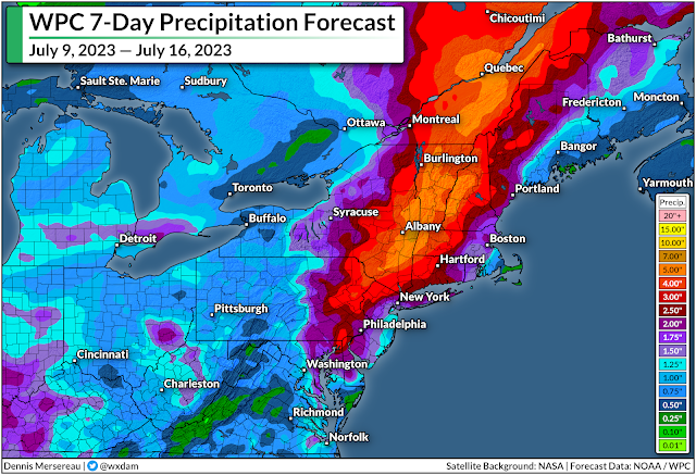
The Weather Prediction Center issued a moderate risk for excessive rainfall across most of interior New England today and tomorrow, with the best chance for flash flooding across New York's Hudson Valley and just about all of Vermont and New Hampshire.

An upper-level low swinging over the region will pull in plenty of moisture from the south. This disturbance will spark widespread showers and thunderstorms, which will easily tap into that vast reservoir of tropical moisture aloft to produce very heavy rainfall.

Source: WPC

Forecasters expect 5-7 inches of rain to fall across this area, much of which may fall in a relatively short period of time. Rainfall rates should easily exceed flash flood thresholds, pushing waterways beyond their limits and likely exceeding the capacity for storm sewers to handle the runoff.

The region's rugged terrain makes flash flooding and landslides a particularly dangerous hazard. Road washouts are likely in areas hit by flooding. Use extreme caution if you're in the area over the next couple of days. It only takes a few inches of moving water to lift a vehicle and carry it downstream.

The risk for road washouts enhances the potential that there may not even be a road anymore beneath the moving waters. It's impossible to tell how deep the water is—or if the road is even still there—before it's too late.


You can follow me on Facebook, Mastodon, Twitter, Instagram, or send me an email.

Please consider subscribing to my Patreon. Your support helps me write engaging, hype-free weather coverage—no fretting over ad revenue, no chasing viral clicks. Just the weather.