August 31, 2022

Where Are All The Atlantic Hurricanes?


If a new tropical storm doesn't form over the Atlantic Ocean by midnight tonight, we'll have witnessed one of the only Augusts on record without any named storms across the Atlantic basin.

That seems like quite the feat for a season that almost all experts expected to produce above-average tropical cyclone activity over the Atlantic. Most seasonal forecasts called for 14-20ish named storms this year thanks to a persistent La Niña over in the eastern Pacific Ocean.

We've only had three named storms through the morning of August 31st. Our last named storm, Tropical Storm Colin, dissipated on July 3rd.

SOURCE: Climate Prediction Center

La Niña—an extended period of cooler-than-normal waters in the eastern Pacific around the equator—usually provides favorable conditions over in the Atlantic by reducing the destructive wind shear that can tear a budding tropical cyclone to shreds before it ever has a chance to develop.

Tropical cyclones are fragile, though, and it takes quite a bit of aligning for a complex of storms to grow into a tropical storm and beyond.

Save for those three storms we had early on in the season, every disturbance that's formed in the Atlantic so far has fizzled out due to some combination of destructive wind shear, puffs of dry dust-filled air blowing off the Sahara, or marginal instability not allowing thunderstorms to reach their full potential.

Unless there's a nightmarish rush of storms over the next two months—which isn't totally out of the realm of possibility, as we've learned in the past few years—it appears pretty likely that the 2022 Atlantic hurricane season will struggle to see an above-normal number of storms.

But, as the old cliché goes, it really only takes one storm to make even a sluggish season a tragedy. Take the 1992 hurricane season as an example. That season's first named storm didn't form until the end of August. It was Hurricane Andrew.

SOURCE: National Hurricane Center

The peak of the season is the second week of September, after all, and we're not going to be able to completely escape any tropical development the rest of the season. If the month does end without any named storms, it'll have been a close call.

The National Hurricane Center has three disturbances in the Atlantic pegged for potential development over the next five days.

A vigorous disturbance east of the Lesser Antilles that has the best chance of developing into something by this weekend. Another low-pressure system out in the middle of the Atlantic could develop into a storm this week, and there's a third disturbance coming off Africa that could slowly develop heading into next week.

Enjoy the relative peace and quiet during what's supposed to be the most active time of the year for hurricanes. Use this downtime to make sure your emergency supplies and plans are in order in case something threatens your area over the next few months. It's important to prepare for storms even if you're hundreds of miles inland—some of the worst impacts from recent storms were from flash flooding and power outages that occurred in the days after landfall.

[Top Image: NOAA]


You can follow me on Twitter or send me an email.

Please consider subscribing to my Patreon. Your support helps me write engaging, hype-free weather coverage—no fretting over ad revenue, no chasing viral clicks. Just the weather.


August 30, 2022

Long-Duration Extreme Heat Settling Over Western U.S. To Begin September


We're staring into the gaping maw of yet another heat wave across the western third of the United States. A large ridge making itself at home will bathe the region with excessive heat through the foreseeable future. High heat is dangerous for anyone, but extended spells of hot temperatures are especially dangerous.

An amplified pattern setting up over North America will see a large ridge building over the west while a trough dips over the east. While some folks back east will see cooler temperatures, anyone caught under that ridge is facing the threat for day after day of excessive heat.

Source: Tropical Tidbits

Excessive heat warnings and heat advisories are in place from southern California through northern Washington—even extending north of the border into British Columbia and Alberta—through at least the end of the week. It's likely that some of the warnings and advisories will be extended into early next week.

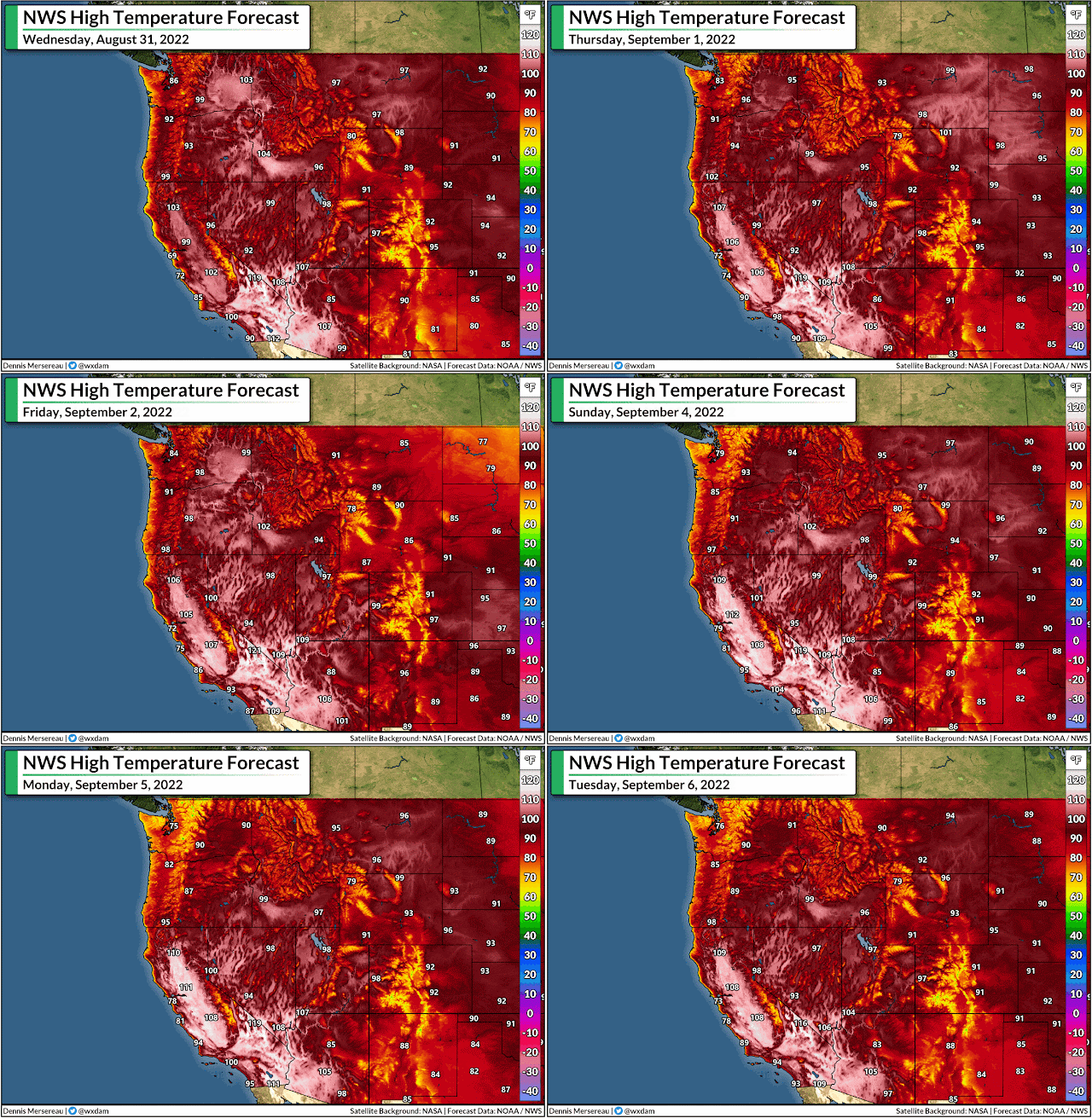
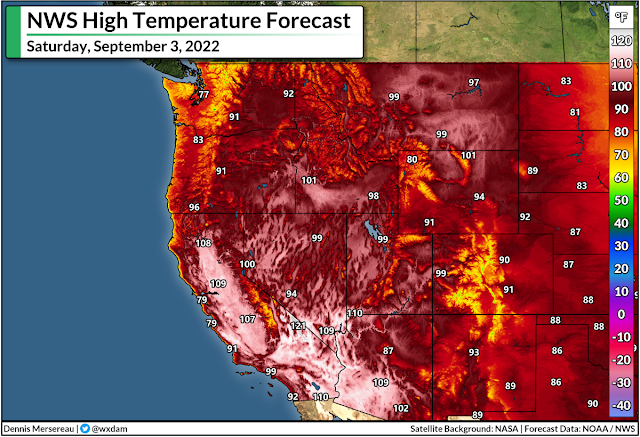
We're looking at triple-digit daytime high temperatures for a wide expanse of the west, with the worst of the heat building in toward the weekend as the ridge intensifies over the region.

Los Angeles could crack the 100-degree mark on Saturday or Sunday, with no relief on the way until late next week. It's not exactly going to be a dry heat for LA, either, with dew points hovering around 60°F keeping things just muggy enough to make the heat feel even worse.

This is an animation of the NWS high temperature forecast between Wednesday 8/31 and next Tuesday 9/6. It may take a moment to load on your device.

The compounding heat of a long heat wave is a silent danger. Hot days dribbling into stuffy nights takes a serious toll on folks who don't have access to air conditioning or clean, reliable water. Heat events like this can claim more lives than we'd see in several years of tornado outbreaks combined.


Heat is most dangerous for vulnerable people, but very hot temperatures can take a toll on even the fittest person. Too many people succumb to heat exhaustion or worse by pushing themselves in the heat of the day.

Be mindful of what your body is telling you. Drink more water than you think you need to. Take breaks to cool off even if you don't want to. I'm guilty of it myself. It's tough to take it easy when you're used to pushing it.


You can follow me on Twitter or send me an email.

Please consider subscribing to my Patreon. Your support helps me write engaging, hype-free weather coverage—no fretting over ad revenue, no chasing viral clicks. Just the weather.


August 21, 2022

Tropical Downpours Fueling Widespread Flash Flood Threat Across Southern U.S.


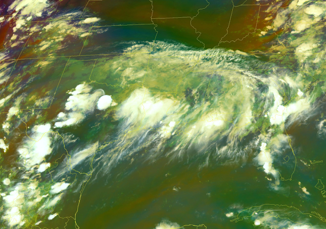
The southern half of the United States finally dove into a wet pattern after so many weeks (and weeks, and weeks...) of hot and dry conditions. We're feeling tropical moisture associated with a disturbance that almost became a tropical storm in the Gulf. Some areas are still in line for more than half a foot of rain through early week, which will lead to flash flooding in spots.

Even though it's been a quiet hurricane season so far this year, the current pattern is a setup we're familiar with around the middle of the summer.

Tropical moisture pumping north serves up a deep reservoir of atmospheric moisture for thunderstorms to tap into and drench whoever gets caught under them. A stationary front parked over the Mid-South provides the trigger to set off these storms for days at a time.


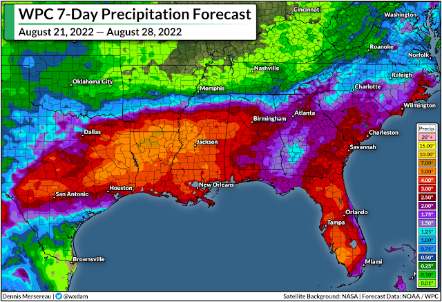
As a result, the latest 7-day rainfall forecast from the Weather Prediction Center (WPC) calls for the potential for 5-8 inches of rain from northeastern Texas through central Mississippi, with the heaviest rains possible over northern Louisiana. Not everyone will see that much rain, of course, but the forecast illustrates the potential for flooding rains wherever those storms happen to set up shop.

Widespread flash flood watches are in effect for the affected areas over the next couple of days.

Flash flooding is one of the deadliest weather hazards in the United States. It's impossible to tell how deep the water is until it's too late, and it only takes a couple of inches of moving water to pick up a vehicle and carry it downstream.

If you live here or you're visiting, make sure you know your way around and plan out alternate routes to get where you need to go in case you come across a road closed due to flooding.


It's been a while since some of these areas have had to deal with a flooding threat. It's been a hot and dry summer across much of the country, and this part of the south is no exception. 

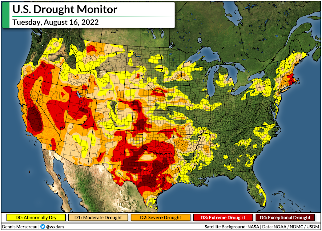
Last week's update of the United States Drought Monitor (USDM) painted widespread drought conditions across the areas seeing these tropical downpours. The long stretch of arid weather has hit northern Texas particularly hard, with extreme to exceptional drought—the two highest categories—stretching into the Dallas area.

While we're likely to see some great improvements in next week's USDM update, this much rain falling this quickly doesn't help as much as a slower, steadier rain would. Gushing downpours tend to run off before they can fully soak into the ground, leading to flash floods for communities that are just looking to catch a break.

[Top Image: NOAA]


You can follow me on Twitter or send me an email.

Please consider subscribing to my Patreon. Your support helps me write engaging, hype-free weather coverage—no fretting over ad revenue, no chasing viral clicks. Just the weather.


August 11, 2022

Relief On The Way As Blissful Cold Front Briefly Kicks East Coast Humidity


Ahhh. While there's nothing better than the first cold front of fall, a cold front that scours away the humidity for a few days in the middle of August has to be a close runner up. A push of cooler, drier air working its way down from Canada will sweep over much of the Northeast and Mid-Atlantic through the weekend, bringing a few days of much-deserved gorgeous conditions.

A Sticky Summer So Far

It's been a relentlessly gross summer so far, with hot temperatures every day and sticky humidity to match. Take a look at these daily high dew point values for the past couple of months here in Greensboro, North Carolina.

Data plot generated using this awesome tool from the Iowa Environmental Mesonet.

The dew point is the best way to measure how muggy or dry the air feels. The air is fully saturated (or 100% relative humidity) when the air temperature meets the dew point temperature.

Dew points below 60°F are comfortable. The air starts to feel muggy between 60-65°F, it's noticeably humid above 65°F, and conditions are downright soupy and tropical once the dew point climbs above 70°F.

It's not just a case of "North Carolina being North Carolina in the summer," either. Here's a look at the same chart for Philadelphia, Pennsylvania:

Source: IEM

Yuck. This year's mugginess even stands out compared to other years through the beginning of August. This is a look at how many hours Philadelphia's dew point came in at 60°F or higher between January 1st and August 9th of each year since 1941.

Source: IEM

This summer-to-date ranks as the fourth-muggiest on record in Philadelphia, and the unusually high moisture levels this season is a repeating story up and down the eastern seaboard.

Thankfully, some short-lived relief is on the way.

Here Comes A Cold Front

A sharp upper-level trough swooping over eastern Canada will bring a cold front sweeping across the region over the next couple of days.

This front will send a flood of cooler, less humid air sweeping over the Northeast and Mid-Atlantic states through the weekend.

Source: Tropical Tidbits

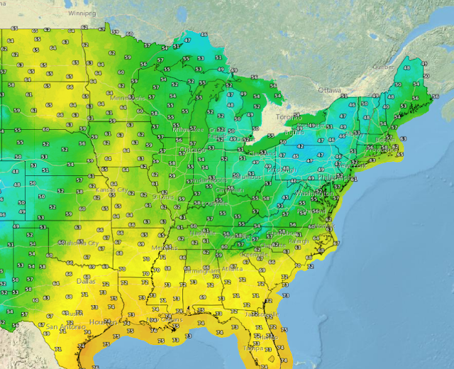
Dew points will fall into the 50s as far south as Georgia and South Carolina, with even drier air likely to spread over the Great Lakes and New England through Sunday.

This is going to feel faaantastic. My goodness. You'll be able to open the windows after dark and air out the house for the first time in months. It'll be gorgeous weather for a nice walk around the neighborhood or a long lounge outside with a refreshing beverage and nothing but the breeze on your face and bugs chirping away.

Enjoy it while it lasts, though. It looks like a storm system will form behind that trough, bringing several days of clouds and rain to the Mid-Atlantic and Northeast heading into early next week.

After that...well, it's still summer, after all. Heat and humidity will start to build back. But the next couple of days will be a nice reminder that we're past the halfway point in this hot summer and fall is on the way.


You can follow me on Twitter or send me an email.

Please consider subscribing to my Patreon. Your support helps me write engaging, hype-free weather coverage—no fretting over ad revenue, no chasing viral clicks. Just the weather.
  

August 6, 2022

Drought Covers Half Of The U.S. As Long, Hot Summer Continues


It's been a long and hot stretch for much of the United States so far this summer, and things aren't looking too good if you're peeking at the forecast for some relief.

Stubborn ridges of high pressure have kept things very warm over much of the country this season, with  folks from the Pacific Northwest to the southeast notching one heat wave after another.

Denver is battling through one of its hottest summers on record up to this point. 9News meteorologist Chris Bianchi tweeted on Friday that Denver's average daily temperature so far this summer is 74.6°F, making this the second-warmest summer through the beginning of August.

Seattle ended July by shattering its longest streak of days with high temperatures of 90°F or hotter. The stretch between July 26th and July 31st recorded highs of 94°F, 91°F, 94°F, 95°F, 95°F, 95°F, respectively, which is way above the city's normal high of about 79°F at the end of the month.


Dallas hasn't seen a below-average high temperature since the end of June, with almost every day this summer notching a high temperature 5-12°F above normal at DFW Airport.

Long, Hot Summer Reinforces Drought

The heat's taken its toll. More than half of the contiguous United States fell into a drought this summer, and things haven't really gotten much better for the hardest-hit areas.


Vast swaths of Texas have seen less than 15 percent of their typical precipitation so far this summer, and deficits are widespread across the rest of the country.

As a result, 51.39 percent of the contiguous U.S. is in a drought as of the August 2nd update of the United States Drought Monitor (USDM). Nearly one-fifth of the country is in a severe or extreme drought, the two highest categories on the USDM's scale measuring the extent and longevity of drought conditions.


The long-term drought across the west stands out like a sore thumb. A beneficial monsoon in recent weeks has put a dent in the southwest's drought, but exceptional drought remains over parts of California's Central Valley, southern Nevada, and portions of central Utah.

Moderate and severe drought conditions have also built across parts of the northern Plains, Mid-South, and across New England. 

Heat Persists For Some, Relieving Rains For Others

The forecast for the rest of the month isn't looking too good for the central U.S., with the Climate Prediction Center (CPC) calling for decent odds of above-average temperatures and below-normal rainfall through the rest of the month.


This kind of pattern will bring better news for the western and eastern portions of the country, with troughs building around the ridge to bring a bit of relief from excessive heat, as well as the chance for rain in areas that could really use it.


You can follow me on Twitter or send me an email.

Please consider subscribing to my Patreon. Your support helps me write engaging, hype-free weather coverage—no fretting over ad revenue, no chasing viral clicks. Just the weather.