August 11, 2025

Tropical Storm Erin set to become Atlantic's first hurricane of 2025


Tropical Storm Erin formed off the Cabo Verde Islands on Monday. The storm is set to become the first hurricane—and possibly the first major hurricane—of the 2025 Atlantic season later this week.

A vigorous tropical wave rolling off the coast of Africa got its act together in a hurry as it emerged over the warm waters of the eastern Atlantic Ocean, quickly organizing into the season's fifth named storm. 


Like all storms that originate in the Cabo Verde region, this is going to be an 8-10+ day marathon watching this storm march west across the Atlantic basin. 

Environmental conditions are favorable for steady intensification in the days to come.


The National Hurricane Center expects Erin to gradually strengthen over the next five days, with the agency's forecast explicitly calling for a major hurricane in the central Atlantic by Wednesday.

These long-duration storms cause quite the anxiety spike among coastal residents who are constantly refreshing weather pages in hopes of learning more about the system's next move.

Unfortunately, it's far too soon to say exactly where the storm will track beyond next weekend. We can look at signals in the models to get an idea of where it may track beyond the end of the NHC's five-day forecast. 

Most tropical storms and hurricanes in the Atlantic are steered along by large ridges of high pressure parked over the center of the ocean. The strength and placement of these highs dictate how far west they travel before they begin to recurve. (Some storms don't recurve at all.)

A model image showing ridges and troughs in the upper atmosphere on Friday evening. SOURCE: Tropical Tidbits

A stronger high-pressure system will allow the system to move farther west, posing a greater threat to the U.S. and Atlantic Canada. A weaker high provides more opportunities for the storm to recurve north and out to sea. 

Right now, signals in the models show decent odds that a weaker high will probably allow Erin to recurve and track near Bermuda before turning out to sea. However, there's plenty of time for things to change. Very small changes in the near-term can have big long-term effects in a storm's track.

We're coming up on the peak of hurricane season. Tropical Storm Erin's impending marathon is a good reminder that folks who live in coastal states and provinces should be ready for storms well before a threat is on the horizon.  

[Satellite image courtesy of NOAA.]


Follow me on Facebook | Bluesky | Instagram

Get in touch! Send me an email.

Please consider subscribing to my Patreon. Your support helps me write engaging, hype-free weather coverage—no fretting over ad revenue, no chasing viral clicks. Just the weather.


November 11, 2024

A new tropical system may develop in the Caribbean this week


The Atlantic hurricane season isn't over just yet. 

Forecasters are watching yet another disturbance in the Caribbean Sea for potential tropical development later this week. The system has a medium (50 percent) chance of development, according to Monday afternoon's tropical weather outlook from the National Hurricane Center.

The disturbance, which is currently south of Hispaniola, will gradually move into the western Caribbean over the next couple of days.


It'll find an environment with relatively low wind shear, decent humidity, and plenty of warm waters to fuel ample thunderstorm development. We could have a tropical depression in the region by the end of the week.

If this system manages to become a tropical storm, it would earn the name Sara as the eighteenth storm of the 2024 Atlantic hurricane season.

This is right where you would expect to see tropical development this late in the year.


High wind shear and puffs of cold, dry air blowing off North America make for an increasingly hostile environment across the Atlantic basin. The favorable conditions of the Caribbean remain one final refuge for late-season storms to try pulling their act together.

Make sure your hurricane preparedness kits and plans are still ready to go in case anything threatens land over the next few weeks. As we've seen several times this year, you don't have to live near the coast for flooding, power outages, and tornadoes to affect communities hundreds of miles inland.


Follow me on Facebook | Bluesky | Threads | Instagram | Twitter

Get in touch! Send me an email.

Please consider subscribing to my Patreon. Your support helps me write engaging, hype-free weather coverage—no fretting over ad revenue, no chasing viral clicks. Just the weather.


October 6, 2024

Milton to hit Florida as a major hurricane on Wednesday


Here we go again. Hurricane Milton is quickly gathering strength over the Gulf of Mexico as it heads east toward Florida over the next few days.

Milton's strange track will take it east over the length of the warm Gulf of Mexico. Favorable conditions will help the storm take advantage of that warm water and force periods of rapid intensification over the next 48 hours. 

The National Hurricane Center expects the storm to rapidly intensify into a major hurricane by Monday, possibly peaking Tuesday as a Category 4 storm with 145 mph winds as it picks up speed toward Florida's western coast.


Forecasters expect that Hurricane Milton will make landfall somewhere on Florida's west-central coast as a major hurricane during the day Wednesday. The precise landfall location is still up in the air a few days out, but this will be a large and growing storm with wide-reaching impacts by the time it makes landfall.

A life-threatening storm surge is likely along the coast, mainly south of the point of landfall. Depending on where Milton makes landfall, this could lead to devastating coastal flooding for some areas. Anyone around Tampa Bay, Charlotte Harbor, or the Caloosahatchee River should heed evacuation orders if and when they're issued.


Widespread flash flooding is possible throughout Florida as heavy rain pounds the state over the next few days even before Milton arrives. 5-8+ inches of rain will fall across Florida through the end of the week, with the highest totals expected in southern Florida and through the center of the state along Milton's expected track.

Remember, never try to drive across a flooded roadway. It's impossible to tell how deep the water is until it's too late, and the road may not be there anymore beneath the waters. It only takes a few inches of moving water to lift up a vehicle and carry it away.

It's been a long time since the Tampa Bay area has faced a direct threat like this. While many storms have grazed the region in the past few decades, the last hurricane to strike Tampa Bay directly was back in 1946


Follow me on Facebook | Bluesky | Threads | Instagram | Twitter

Get in touch! Send me an email.

Please consider subscribing to my Patreon. Your support helps me write engaging, hype-free weather coverage—no fretting over ad revenue, no chasing viral clicks. Just the weather.


September 30, 2024

Helene's Floods: When catastrophe comes to pass


Western North Carolina and eastern Tennessee are reeling this week from the onslaught of historic floods associated with Hurricane Helene.

Entire neighborhoods washed away in the immense flooding. Major highways are severed. Dozens, if not hundreds, of roads no longer exist. Public utilities like water, electricity, and phone services are hanging by a thread if they're connected at all. The death toll, which just climbed above 100 as of this post, will almost certainly rise higher as officials finally make their way into the hardest-hit communities. 

By all accounts, this is the new flood of record for western North Carolina. The previous benchmark event was the Great Flood of 1916, the result of two tropical storms that hit the region one after the other. 


Hurricane Helene's rains were also a one-two punch that overwhelmed the region with more water than it could handle. I wrote more about it for The Weather Network over the weekend.

A predecessor rain event (PRE) brought 8-10+ inches of rain in the days before Hurricane Helene ever made landfall. Saturated soils and swollen waterways were already a major problem by the time Helene's core reached the region, dropping the final push of torrential rains that turned a dangerous situation into pure chaos. 

It was a well-predicted fiasco. The words "catastrophic," "devastating," and "life-threatening" filled the forecasts for days before the floods.
The southern Blue Ridge remains under a high risk for excessive rainfall through Friday, which signals extreme confidence among meteorologists that major flash flooding will occur throughout the region. Flash flooding is possible across areas that may not typically flood. Landslides and road washouts are likely in vulnerable areas. 
It doesn't matter how accurate the forecasts were. Flash flood warnings were timely and plentiful. Meteorologists used phrases like "flash flood emergency" to convey the severity of the situation.

But it's impossible to adequately prepare for 30 inches of rain. You can do everything right—have a plan, buy insurance, monitor the forecasts, heed alerts—and still nothing can prepare you for the aftermath of nearly a year's worth of rain falling in a couple of days.

There are natural catastrophes, and then there are catastrophes made even worse by human failures. Last week's flooding raised comparisons to Hurricane Katrina, the flooding from which killed more than one thousand people. This is not Katrina because Katrina's aftermath was made far worse by a cascade of human failures. Human-made levees failed. The response was slow and botched to a shameful extent. Katrina was a natural catastrophe that coincided with a societal catastrophe.


The flooding that devastated dozens of communities throughout the southern Appalachians was a natural catastrophe through and through. No amount of planning or preparation can contain the runoff from a year's worth of rain falling in mere days. Streams turned to rivers, rivers turned to oceans, and the valleys bore the brunt of nature's impersonal destruction.

Anger is fresh in the wake of a calamitous storm. People want to blame something, someone, anyone, anything, for the havoc that befell a vast swath of our fellow Americans. There's lots of anger aimed at state and federal officials for the seemingly slow response to communities no longer connected to the outside world.

Some of that anger is righteous, but much of it is contrived by outsiders looking to score points off the dripping ruins of their neighbors in need.

Bridges washed out and ravines carved into the earth where roads once existed. How are supplies supposed to instantly hustle into towns now severed from society? Helicopters need somewhere safe to land and rubble-strewn communities are nestled on rugged terrain in tree-lined valleys. Air drops require coordination with people on the ground—people who can't easily drive to where their help is needed the most, and where communication links are tenuous at best.

It's going to be days and possibly weeks before the full scope of Helene's human toll is known to the outside world. Recovery will be measured in months and years. Some residents are almost certainly never going to return; some communities will never rebuild to the way they were before the rain started.

We can shout accurate forecasts from the rooftops. Adequate warnings can make phones sing like slot machines. But when catastrophe comes to pass—a true, generational catastrophe—there's little even our modern conveniences can do to stave off heartbreaking levels of devastation. 


Follow me on Facebook | Bluesky | Threads | Instagram | Twitter

Get in touch! Send me an email.

Please consider subscribing to my Patreon. Your support helps me write engaging, hype-free weather coverage—no fretting over ad revenue, no chasing viral clicks. Just the weather.


September 24, 2024

Helene's damaging winds, flooding rain will extend hundreds of miles inland


Hurricane warnings are now in place for parts of the Gulf Coast as Tropical Storm Helene steadily marches toward the region over the next couple of days. The system could reach major hurricane strength before slamming into the Florida coast on Thursday.

Helene's dangerous weather conditions will extend hundreds of miles inland from the point of landfall, exposing a vast swath of the southeastern U.S. to dangerous winds, flooding rains, and a risk for tornadoes.

Current Status & Predicted Path


The storm rapidly organized into Tropical Storm Helene during the day on Tuesday as it moved over the warm waters of the western Caribbean Sea. Forecasters expect the storm to thread the needle between the Yucatan Peninsula and the western tip of Cuba over the next day, coming very close to Cancun on Wednesday.

A sharp upper-level trough over the southern U.S. will pick up the storm and force it to turn on a north-northeasterly track toward Florida's Gulf Coast. 

Things will happen quickly once Helene enters the Gulf late Wednesday.


Extremely warm waters and favorable environmental conditions should allow the storm to rapidly intensify into a major hurricane by Thursday. The latest forecast from the National Hurricane Center brings Helene into the Florida Panhandle or the state's Big Bend region as a major hurricane on Thursday evening.

This is going to be a large hurricane with a sprawling footprint as it hits the southeastern U.S. Damaging winds, storm surge flooding, freshwater flooding from heavy rain, and a threat for tornadoes will extend hundreds of miles away from the center of the storm.

Flooding Rains


Widespread flooding rains will pose the greatest threat to the most people as Helene pushes inland. A wide swath of 5-10+ inches of rain will follow the storm from Florida into the Carolinas.

This much heavy rain falling in such a short period of time will lead to significant flash flooding across vulnerable areas, and we may see flooding in areas that typically don't experience it during heavy rainfall.

Flash flooding and landslides will be a particular concern across the southern Blue Ridge as orographic lift—winds flowing up the sides of the mountains—will enhance rainfall totals across the western Carolinas and northern Georgia. Some areas may see double-digit rainfall totals by this weekend.

Please remember and spread the word: it's never safe to drive across a flooded roadway. It's impossible to tell how deep the water is until it's too late, and the road may be washed out beneath the floodwaters. It only takes a few inches of moving water to lift up a vehicle and carry it downstream.

Damaging Winds & Storm Surge Flooding

While rain will be the biggest threat from this storm, we can't ignore the looming impact of damaging winds as this soon-to-be-hurricane approaches land.


Communities near the point of landfall could see destructive sustained winds in excess of 115 mph, which will cause structural damage in addition to a massive blowdown of trees and power lines. Power outages near the point of landfall could last for weeks.

Helene's winds won't stop at the coast. Sustained winds of 70+ mph will follow the core of the storm as it pushes across the Florida Panhandle and into southern Georgia. Major tree damage and downed power lines are likely throughout cities like Tallahassee, Valdosta, Albany, and possibly even up toward Macon.

Based on the storm's current projected path, wind gusts of 40-60+ mph are possible into northern Georgia, including metro Atlanta, as well as into the western Carolinas, which may include Greenville, Spartanburg, and the Charlotte metro area. This will lead to downed trees and power outages throughout the region.

SOURCE: NHC

Helene's intense winds will push a destructive, life-threatening storm surge into the coast. Storm surge flooding could rise 10-15 feet above ground level near the point of landfall if the surge coincides with high tide. We can only hope that the worst surge inundates unpopulated areas of the swampy Florida coast.

The storm's growing size will make a storm surge of 5-8 feet possible across Florida's west coast, including the Tampa Bay area. This much storm surge flooding will easily inundate neighborhoods near the coast. Please heed all evacuation orders issued by local officials.

Tornado Risk


Tornadoes are an ever-present hazard when a tropical system rolls ashore. Strong wind shear within the storm can cause spin-up tornadoes to occur within the storm's outer rain bands. These tornadoes can happen very quickly with reduced tornado warning lead times. 

Tornadoes are most likely on the eastern side of a landfalling storm, which places the greatest risk for tornadoes across large portions of Florida and Georgia, as well as eastern sections of the Carolinas.

Make sure you've got emergency alerts activated on your phone so you can get warnings the moment they're issued for your location. These free push alerts are a proven lifesaver in the critical moments ahead of a tornado—especially when your reaction time is reduced.

NHC Updates

The National Hurricane Center releases full forecast packages—including updated cones and wind forecasts every six hours, at 11:00 a.m./p.m. and 5:00 a.m./p.m.

When there are watches and warnings in effect, the agency also releases intermediate updates every three hours in between. These advisories provide status updates on the storm's current location and conditions, as well as any changes to watches and warnings that are in effect.


Follow me on Facebook | Bluesky | Threads | Instagram | Twitter

Get in touch! Send me an email.

Please consider subscribing to my Patreon. Your support helps me write engaging, hype-free weather coverage—no fretting over ad revenue, no chasing viral clicks. Just the weather.


September 23, 2024

Prepare now: A hurricane is likely in the Gulf of Mexico this week


A disturbance in the western Caribbean has a very high likelihood of rapidly intensifying into a hurricane over the next couple of days as it closes in on the Gulf Coast. 

This isn't the kind of storm we get to watch for a week and a half before anyone has to take action. This is going to be a very fast developing storm, and we could be less than 72 hours away from dangerous winds and flooding rains beginning to sweep over the southeastern United States. 

A Budding Hurricane Is Likely

The National Hurricane Center began issuing forecasts on soon-to-be-Helene on Monday afternoon. The agency's opening bid calls for the storm to rapidly intensify into a hurricane as it enters the Gulf of Mexico over the next 36 hours. The storm could approach major hurricane intensity by the time it makes landfall during the day on Thursday.

A complex pattern of upper-level winds over the United States will affect future-Helene's path over the next few days. The storm will start to curve northeast once it enters the Gulf of Mexico, likely taking it on a path toward the Florida Panhandle or the state's Big Bend region.


It's worth noting that everyone from Tampa to Pensacola is currently in the cone of uncertainty, which is the historical margin of error in the NHC's track forecasts.

There are several key factors that meteorologists are still struggling with right now. The biggest is that the storm hasn't actually developed yet. This disturbance is still a disorganized cluster of thunderstorms over the Caribbean. Forecasters and weather models both will have a clearer idea of the storm's future once it actually develops.

Here are a few potential scenarios we could see over the next few days.

Potential #1: Worst-Case Scenario

The worst-case scenario is that future-Helene will rapidly intensify as it approaches land, strengthening into a major hurricane before it makes landfall on Thursday.


Sea surface temperatures across the Gulf of Mexico are extremely warm, running several degrees above average for the end of September. Warm waters are like rocket fuel to a budding storm.

These warm waters and a favorable environment around the storm could allow future-Helene to rapidly intensify up through landfall on Thursday.

Potential #2: A Dangerous But Weaker Storm

A second realistic scenario is that future-Helene will struggle to get its act together. Any delay in the storm's ability to organize would be good news for coastal residents. A delayed hurricane means it's likely that a slightly weaker storm would make landfall.

We'd still see damaging winds and storm surge flooding at the coast, as well as prolific heavy rains far inland, but it wouldn't be the high-end system those steamy ocean waters are capable of supporting.

Potential #3: Best-Case Scenario

The best-case scenario is actually two different potential hiccups in the storm's future.

Some otherwise-promising disturbances never manage to get their act together. It's not out of the question that this disturbance will struggle for its entire life, reaching shore as a relatively weak and disheveled system that's more of a flood threat than a multi-faceted disaster.


A second point of failure may be Hurricane John over in the eastern Pacific Ocean. That storm is close enough to the western coast of Mexico that it could throw off upper-level wind shear that travels east over the Caribbean and southern Gulf of Mexico.

Wind shear disrupts the updrafts in thunderstorms trying to form around the center of a system. If the Pacific hurricane throws off enough wind shear—which isn't out of the question—it could be an unexpected wild card in future-Helene's ultimate development.

Prepare For Significant Impacts—Even Far Inland

Folks who live along the northern and eastern Gulf Coast should prepare for this storm's arrival no matter what happens over the next couple of days. 


Widespread flash flooding from heavy rain is likely for hundreds of miles inland across the southeastern United States after the system makes landfall later this week. Rainfall totals of 3-5+ inches are expected all the way into portions of the Midwest. Extensive heavy rain could lead to major flooding issues throughout the southern Blue Ridge region.

If the storm intensifies as expected, widespread and long-lasting power outages could follow the center of the storm inland and affect communities throughout northern Florida, eastern Alabama, and much of southern and central Georgia. Make sure you're prepared for power outages even if you're hundreds of miles away from the coast.

Tornadoes are always a concern with landfalling storms. Communities on the eastern side of the storm will be most vulnerable to spin-up tornadoes, including across Florida, Georgia, and possibly into portions of Tennessee and the Carolinas. 


Follow me on Facebook | Bluesky | Threads | Instagram | Twitter

Get in touch! Send me an email.

Please consider subscribing to my Patreon. Your support helps me write engaging, hype-free weather coverage—no fretting over ad revenue, no chasing viral clicks. Just the weather.


November 4, 2023

Rapidly intensifying hurricanes truly are the 'nightmare scenario'


Historic disasters have transitioned from a noteworthy abnormality to something that we've come to expect on a regular basis.

Unprecedented heat, devastating fires, destructive flash floods, and rapidly intensifying hurricanes are just the way things are. "Another billion-dollar flash flood? Add it to the two other we've seen this month."

This is going to be a more 'personal' post than I usually write for DAMWeather. I've covered a century's worth of unprecedented weather events in the past couple of years—almost all of it in a straight-news format.

I can't bring myself to do that for Hurricane Otis. I've spent almost two weeks trying (and failing) to write about the scale-topping hurricane that devastated Mexico's Acapulco region on October 24.

There are lots of worst-case scenarios when it comes to weather disasters. Hurricane Otis is one of the only storms in recent years that can legitimately claim the title of a worst-case scenario.

Hurricanes rapidly intensifying as they approach landfall is an alarmingly common disaster these days, and it's a horror that both people and governments still aren't prepared to confront.

Otis unexpected leapfrogged to a category five titan

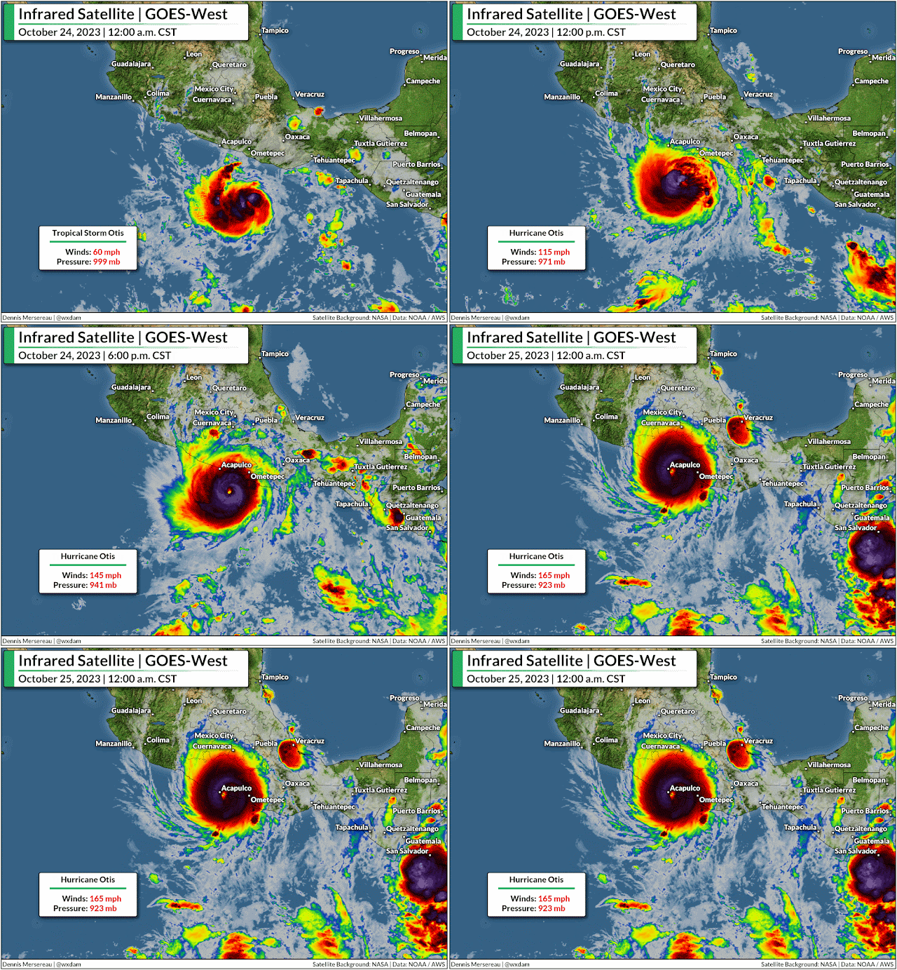
Otis rapidly intensified from a 50 mph tropical storm to a category five hurricane with 160 mph winds in just 24 hours, and it slammed almost head-on into Acapulco and its 1,000,000+ residents at maximum strength.


Hurricane Otis' explosive growth is one of the most intense rapid intensification events ever observed—beaten only by Hurricane Patricia in 2015, which peaked as the strongest hurricane ever reliably observed when its maximum winds reached 215 mph.

"The National Hurricane Center didn't mince words" is a phrase uttered too many times in the past five years as one record-busting hurricane after another swirled into yet another vulnerable swath of coastline somewhere in North America.


But the experts who dedicate their professional lives to tracking and understanding these atmospheric behemoths were flabbergasted by the hurricane's rapid growth. No forecaster or their computer models foresaw the storm growing into a major hurricane before landfall. The official NHC forecast called for Otis to maybe just barely crack hurricane strength as it crossed the coastline.

So to watch this hurricane run away in the atmospheric chain reaction from hell as it closed in on a heavily populated metro area was truly the 'nightmare scenario,' as an NHC forecaster said in the agency's update declaring the storm a scale-topping category five.


The nightmare played out.  We may never know exactly how strong the winds got in the heart of the city of more than one million people, but precise wind speeds seem irrelevant given the widespread destruction across the region.

Ten storms in ten years

Otis joined a long list of recent hurricanes that rapidly intensified in the run-up to landfall.

Harvey grew from a tropical depression to a category four storm as it approached Texas in September 2017.

Irma, once a scale-topping category five, rapidly reintensified into a category four when it hit the Florida Keys just two weeks later, keeping most of its power as it hit the state head-on soon after.

Source: NOAA

Two weeks after that, Maria rapidly intensified into a category four hurricane as it slammed into Puerto Rico.

Hurricane Michael exploded into a category five with 160 mph winds as it hit the Florida Panhandle in October 2018.

During the historic 2020 hurricane season, Laura quickly intensified into a 150 mph hurricane as it walloped southwestern Louisiana, barely losing strength at first as it drew energy from the swampy, surge-covered land. Exactly one year later, Hurricane Ida did the exact same thing as it hit southeastern Louisiana.

A year after that, Hurricane Ian intensified into a category five storm just before making landfall in southwestern Florida. The storm's destructive wind and surge killed more than 100 people, making it Florida's deadliest hurricane in a century.

This past August, Hurricane Idalia rapidly intensified in the eastern Gulf of Mexico and hit the Florida Panhandle as a category three storm. It was the strongest storm ever recorded at landfall in this part of the state.

That's just Atlantic hurricanes that revved up as they closed in on shore. There have been plenty of storms that rapidly intensified out to sea, and it doesn't even cover the storms—like Otis and unparalleled Hurricane Patricia from 2015—we've seen follow this trend in the eastern Pacific Ocean, or in the world's other tropical basins.

Consistently warm waters fuel rapid intensification trends

We've seen a tremendous stretch of unprecedented warmth across almost the entire Atlantic basin this year. It's the reason we've seen 20 tropical storms and hurricanes this year despite a strong El Niño over in the eastern Pacific.

The destructive wind shear generated by El Niño typically shreds apart any attempted tropical cyclones over the Atlantic. But sea surface temperatures in the Atlantic are so warm that any disturbance had the opportunity to develop—and they took full advantage of that unusual environment.


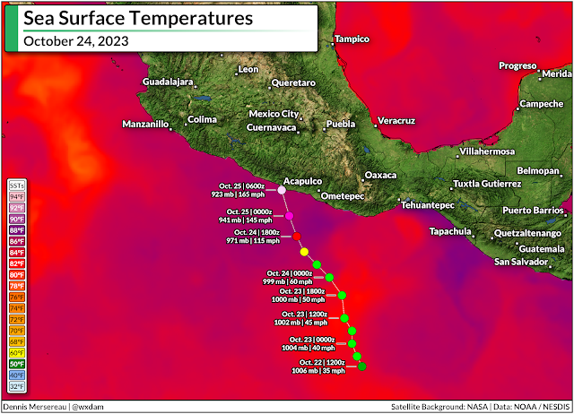
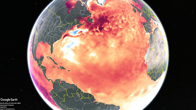
We can even see the influence of freakishly warm water when it comes to these eastern Pacific storms. Water temperatures off the western coast of Mexico were unusually warm when Hurricane Otis tracked over the region. Overlay the storm's track on top of a map of sea surface temperatures and it's easy to see a major reason that storm surpassed the most aggressive forecasts.

Time and time again, exceptionally warm sea surface temperatures are the driving force behind these rapid intensification events. It's not the whole story—a nearby jet stream improved Otis' outflow, for example, helping the hurricane strengthen in hyperdrive—but the freakish warmth in the Atlantic in recent years, and this year in particular, is a worrisome data point when it comes to future storms.

As the planet and its oceans continue to warm, we may have to contend with more of these sudden rapid intensification events in the future, including as storms snake toward landfall. 

That's downright terrifying when so many communities seem incapable of preparing for a storm they have a week to see coming. I recently wrote about our "strained attention economy" as a major reason so many well-advertised disasters seem to hit people by complete surprise. I am not confident that most people or community leaders are prepared for 'average' hurricanes, let alone these monstrous storms that ramp up within hours of landfall.

We've seen an entire lifetime's worth of tropical devastation from a handful of storms in the past couple of years. This year's amped-up storms won't be the last ones we see. At the very least, it's a strong argument to pay incredibly close attention to the weather during hurricane season, as the storm you went to sleep watching might not be the same one staring you down when you wake up.


Follow me on Facebook | Bluesky | Threads | Instagram | Twitter

Get in touch! Send me an email.

Please consider subscribing to my Patreon. Your support helps me write engaging, hype-free weather coverage—no fretting over ad revenue, no chasing viral clicks. Just the weather.


October 21, 2023

Active 2023 Atlantic hurricane season lands in records despite a strong El Niño


Hurricane warnings are up for portions of the Lesser Antilles this weekend as an unlikely storm lashes the region with high winds and heavy rainfall.

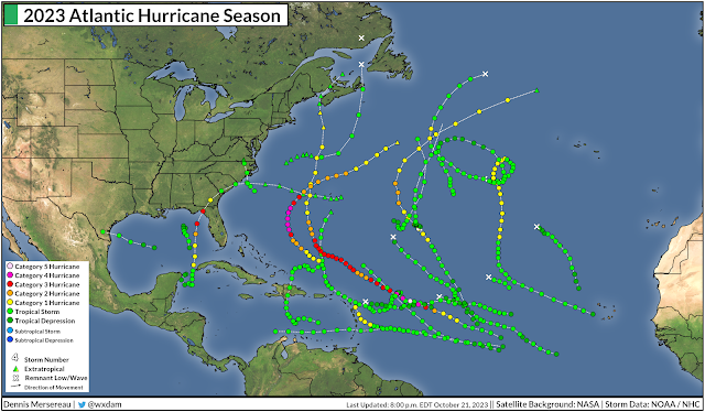
Hurricane Tammy is our 20th named storm of this remarkable hurricane season. It's noteworthy to have that many named storms in any circumstances—2023 is now tied for fourth-most active Atlantic hurricane season on record—but we're in the midst of a strong El Niño, which typically stifles tropical cyclone activity across the Atlantic.

Tammy Makes Twenty

We've had 20 nameable storms across the Atlantic Ocean so far this season. The first system was an unnamed subtropical storm that forecasters added to the record in a reanalysis of the event a few months later.


Seven of the storms grew into hurricanes, and three of those storms—Franklin, Idalia, and Lee—managed to balloon into major hurricanes. Even more impressive is that Lee briefly grew into a category five storm, one of only a few dozen ever recorded over the ocean basin.

Tropical activity in the Atlantic typically slows down and moves closer to the Caribbean and Gulf as we head into October, but Tammy is especially unusual because it's a full-blown hurricane with roots in a tropical disturbance that originated over sub-Saharan Africa.

El Niño Strongly Influences Atlantic Hurricanes

The eastern Pacific Ocean around the equator is usually pretty chilly due to upwelling of frigid waters from deep within the ocean. Easterly winds blowing across the equatorial Pacific push warm surface waters toward Australia, strengthening the upwelling off South America as waters rise from below to fill the void.

When those easterly winds weaken or reverse direction, however, that warm surface water floods back toward South America. These warmer waters of an El Niño aren't much—just a couple of degrees—but it's enough to significantly affect the atmosphere in ways that have far-reaching effects from Asia to Africa.

Source: NOAA Data Snapshot

Even though El Niño's effects are most noticeable during the winter, these unusually warm waters can beef-up thunderstorm activity across the eastern Pacific—creating wind shear that blows east over the Atlantic Ocean. This wind shear is (usually) destructive to any budding tropical cyclones over the Atlantic, putting an end to them before they have a chance to flourish.

That's usually how things go. The 1991 and 1992 hurricane seasons were relatively quiet due to a lengthy El Niño. 1991 only saw eight named storms, while 1992's first named storm—the infamous Hurricane Andrew—didn't form until the end of August.

The last underactive hurricane season we saw in the Atlantic took place at the tail-end of a strong El Niño in 2015, when only 11 named storms managed to form.

2023 Breaks The Rules

This year should've followed suit. A strengthening El Niño over the eastern Pacific normally would've put a lid on the Atlantic Ocean this year, stifling most opportunities for storms to develop.

That very much didn't happen. But why?

Forecasters knew in advance that we might be in for a trend-bucking season before it even began.

"El Nino’s potential influence on storm development could be offset by favorable conditions local to the tropical Atlantic Basin," NOAA wrote in its initial seasonal outlook published back in May.


The factors they outlined in their forecast pretty much came to pass. Sub-Saharan Africa saw a fruitful monsoon season this summer and fall, which pumped one disturbance after another into the eastern Atlantic Ocean.

Sea surface temperatures across the Atlantic have been historically warm so far this year, as well. The increase in disturbances, combined with the mind-boggling heat across the entire basin, afforded more opportunities for systems to develop and thrive.

For all the activity we've seen, El Niño did still flex its muscles. Many of the storms we've seen this year were relatively weak, largely struggling with destructive wind shear that's characteristic of El Niño years.

But those favorable factors around the Atlantic basin combined to overpower El Niño and cement 2023's spot in the history books as one of the most productive hurricane seasons ever witnessed. And it's not quite over yet. It's not out of the question that we could see another couple of storms over the next month or so.


There are only two names left on this year's list. If we use those names and require a 23rd name, the National Hurricane Center would dive into the new supplemental list of names, beginning with Adria. This supplemental list replaced the use of Greek letters to name excess storms, a change made after the hyperactive (and at times confusing) 2020 hurricane season.

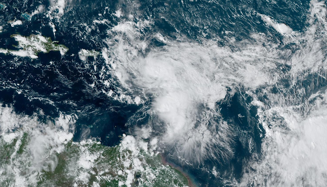
[Satellite image via NOAA]


Follow me on Facebook | Bluesky | Threads | Instagram | Twitter

Get in touch! Send me an email.

Please consider subscribing to my Patreon. Your support helps me write engaging, hype-free weather coverage—no fretting over ad revenue, no chasing viral clicks. Just the weather.


August 31, 2022

Where Are All The Atlantic Hurricanes?


If a new tropical storm doesn't form over the Atlantic Ocean by midnight tonight, we'll have witnessed one of the only Augusts on record without any named storms across the Atlantic basin.

That seems like quite the feat for a season that almost all experts expected to produce above-average tropical cyclone activity over the Atlantic. Most seasonal forecasts called for 14-20ish named storms this year thanks to a persistent La Niña over in the eastern Pacific Ocean.

We've only had three named storms through the morning of August 31st. Our last named storm, Tropical Storm Colin, dissipated on July 3rd.

SOURCE: Climate Prediction Center

La Niña—an extended period of cooler-than-normal waters in the eastern Pacific around the equator—usually provides favorable conditions over in the Atlantic by reducing the destructive wind shear that can tear a budding tropical cyclone to shreds before it ever has a chance to develop.

Tropical cyclones are fragile, though, and it takes quite a bit of aligning for a complex of storms to grow into a tropical storm and beyond.

Save for those three storms we had early on in the season, every disturbance that's formed in the Atlantic so far has fizzled out due to some combination of destructive wind shear, puffs of dry dust-filled air blowing off the Sahara, or marginal instability not allowing thunderstorms to reach their full potential.

Unless there's a nightmarish rush of storms over the next two months—which isn't totally out of the realm of possibility, as we've learned in the past few years—it appears pretty likely that the 2022 Atlantic hurricane season will struggle to see an above-normal number of storms.

But, as the old cliché goes, it really only takes one storm to make even a sluggish season a tragedy. Take the 1992 hurricane season as an example. That season's first named storm didn't form until the end of August. It was Hurricane Andrew.

SOURCE: National Hurricane Center

The peak of the season is the second week of September, after all, and we're not going to be able to completely escape any tropical development the rest of the season. If the month does end without any named storms, it'll have been a close call.

The National Hurricane Center has three disturbances in the Atlantic pegged for potential development over the next five days.

A vigorous disturbance east of the Lesser Antilles that has the best chance of developing into something by this weekend. Another low-pressure system out in the middle of the Atlantic could develop into a storm this week, and there's a third disturbance coming off Africa that could slowly develop heading into next week.

Enjoy the relative peace and quiet during what's supposed to be the most active time of the year for hurricanes. Use this downtime to make sure your emergency supplies and plans are in order in case something threatens your area over the next few months. It's important to prepare for storms even if you're hundreds of miles inland—some of the worst impacts from recent storms were from flash flooding and power outages that occurred in the days after landfall.

[Top Image: NOAA]


You can follow me on Twitter or send me an email.

Please consider subscribing to my Patreon. Your support helps me write engaging, hype-free weather coverage—no fretting over ad revenue, no chasing viral clicks. Just the weather.