January 19, 2023

Enhanced Risk For Severe Storms Across Ohio Today, Because Of Course, It's January 19th


There's an enhanced risk for severe weather across much of Ohio today.

Of course.

Because that's just what you'd expect for the middle of January.

A low-pressure system moving across the Great Lakes region is responsible for all sorts of foul weather across the central U.S. this week. The system plastered a solid swath of snow from Denver to Duluth over the past couple of days.

Now that most of the wintry weather is north of the border in Ontario, we're left to deal with the volatile southern end of the storm today.

The core of the low will spend Thursday scooting across the Midwest in a hurry. Southerly winds feeding into the center of the low will drag warm, humid air from the south. The system's cold front will crash into this modestly unstable air, made a little more unstable by the amount of cold air aloft.


This setup will lead to a fast-moving line of severe thunderstorms developing along that cold front during the latter half of the afternoon. We'll see the squall line develop in central Indiana not long after noon, racing east into Ohio through the mid- to late-afternoon hours.

You can see a simulated radar image from the HRRR weather model at the top of this post, covering the 5:00 p.m. timeframe. 

A risk for severe weather covers about all of Ohio on Thursday afternoon, radiating out to include eastern Indiana, western Pennsylvania, and far northern Kentucky. Within that area is a bullseye of sorts, an enhanced risk—a three out of five on the categorical scale measuring the risk for severe storms—that includes Dayton and Columbus.

Damaging wind gusts are far and away what concerns the Storm Prediction Center the most with Thursday's storms. The enhanced risk is in effect for the potential for significant wind gusts of 75+ mph, which are plenty strong enough to knock down trees and power lines across the affected areas.


There's also a small—but not zero—risk for tornadoes in and around the enhanced risk. This kind of setup carries the risk of "kinks" developing along the leading edge of the squall line, which could spin up short-lived but fast-moving tornadoes.

Honestly, the most dangerous part of today's severe weather risk is the fact that it's January 19th.

Severe storms are more common in Alabama and Louisiana this time of year. Not so much in Ohio! Many folks across the affected areas won't be tuned-in to severe thunderstorm watches and warnings as these fast-moving storms approach.

If you live in the area, please let your family, friends, and neighbors know that there's a risk for rockin' storms today. If you know anyone in the area, drop a note on Facebook or Twitter or Mastodon or wherever that these storms are coming this afternoon.

Severe weather is dangerous any day, but it's even worse in the winter when most folks aren't on the lookout for watches and warnings.

The risk for severe weather will quickly diminish after sunset, and no more severe thunderstorms are in the forecast for the remainder of the week.

As it should be.

In January.

[Top Image: WSV3]


You can follow me on Facebook, Mastodon, Twitter, Instagram, or send me an email.

Please consider subscribing to my Patreon. Your support helps me write engaging, hype-free weather coverage—no fretting over ad revenue, no chasing viral clicks. Just the weather.


January 4, 2023

California Flood Risk Ramps Up As Another Atmospheric River Washes Over West Coast


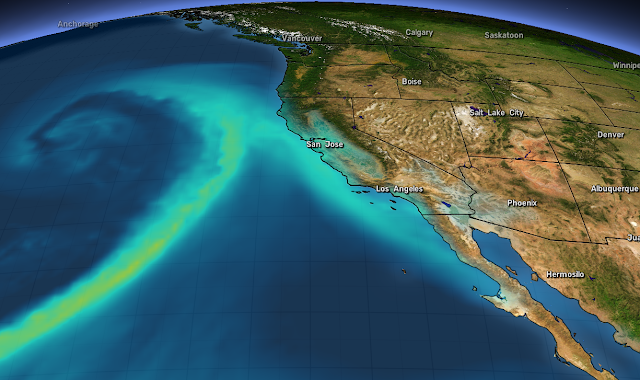
Widespread heavy rain, high winds, and many feet of mountain snows are on the way to California over the next couple of days as another powerful storm swirls off the coast.

This latest wash of heavy rain will lead to a heightened flood risk for much of coastal California, with many communities still cleaning up the damage from the prolific rains that fell over the weekend.

We're in the midst of an exceptionally unsettled stretch of weather across the West Coast as a series of potent low-pressure systems take aim at the region.

This week's atmospheric river will bring the risk for several inches of rain across a wide swath of coastal California. The Sierra Nevada will see very heavy snow, with areas above 5,000 feet piling up multiple feet of snow over the next few days.

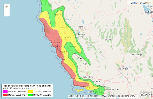
Source: NWS/WPC

The Weather Prediction Center (WPC) issued a moderate risk for excessive rainfall for much of the day Wednesday. This means that there's at least a 40 percent chance of rain exceeding flash flood guidance, or rain falling fast enough to trigger flash flooding in certain areas. Moderate risks don't come around too often, so that's a strong sign that vulnerable areas will see dangerous conditions.

We'll see high winds accompany the heavy rainfall through Thursday. Much of California is plastered in high wind warnings as gusts will reach 40-60 mph in most areas. Higher elevations could see gusts up to 70 mph at times. Since the ground is soaked from recent and ongoing rains, the winds will likely lead to tree damage and power outages in spots.


It's not over once this storm moves along, either.

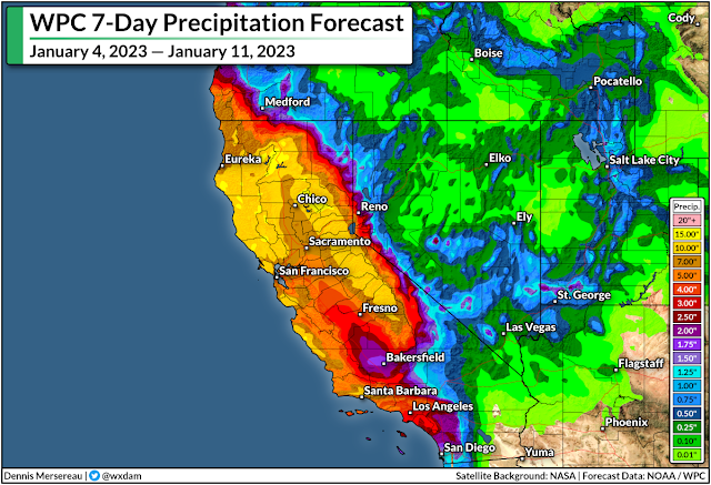
The WPC's latest precipitation outlook for the next seven days shows 10-15+ inches of rain falling on a huge swath of California through next week, with the heaviest precipitation focused on northern California and the mountains.

A continued train of storms will focus on California in the coming days, with about a day or two of spacing between each one. We're seeing this relentlessly wet pattern as a result of a powerful jet stream sagging pretty far down over the Pacific Ocean.

Source: Tropical Tidbits
This jet isn't moving very much, so it has the opportunity to pump out one storm after another as each trough breaks at the end of the jet like a wave crashing on the beach.

Additional strong systems could reach the coast by this weekend, early next week, and late next week.

Remain mindful of the dangers of flash flooding. It's impossible to tell how deep the water is until it's too late. It takes surprisingly little moving water to lift up a vehicle and carry it away. Most freshwater flooding deaths in the U.S. occur when people drive their vehicles into deep or moving waters. Sometimes, especially in a hilly state like California, the road may be completely washed out under the water.

If you're under a wind advisory or high wind warning, you're at risk for power outages. It'll take crews longer to restore power during bad weather.

Make sure you've got batteries and flashlights on hand so you can see in the dark without wasting your cell phone battery on the flashlight feature. Rechargeable cell phone battery packs are also a great investment—they're relatively cheap now and most can provide one or two boosts to a smartphone's charge.

[Top image created using WSV3]

You can follow me on Facebook, Mastodon, Twitter, Instagram, or send me an email.

Please consider subscribing to my Patreon. Your support helps me write engaging, hype-free weather coverage—no fretting over ad revenue, no chasing viral clicks. Just the weather.