Widespread heavy rain, high winds, and many feet of mountain snows are on the way to California over the next couple of days as another powerful storm swirls off the coast.
This latest wash of heavy rain will lead to a heightened flood risk for much of coastal California, with many communities still cleaning up the damage from the prolific rains that fell over the weekend.
This week's atmospheric river will bring the risk for several inches of rain across a wide swath of coastal California. The Sierra Nevada will see very heavy snow, with areas above 5,000 feet piling up multiple feet of snow over the next few days.
 |
| Source: NWS/WPC |
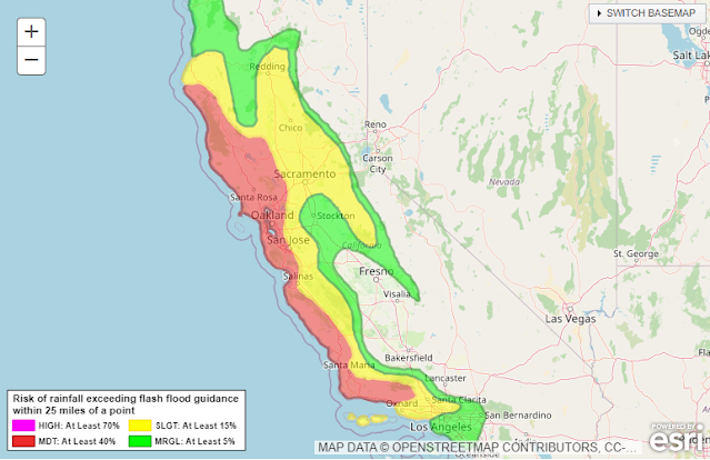
The Weather Prediction Center (WPC) issued a moderate risk for excessive rainfall for much of the day Wednesday. This means that there's at least a 40 percent chance of rain exceeding flash flood guidance, or rain falling fast enough to trigger flash flooding in certain areas. Moderate risks don't come around too often, so that's a strong sign that vulnerable areas will see dangerous conditions.
We'll see high winds accompany the heavy rainfall through Thursday. Much of California is plastered in high wind warnings as gusts will reach 40-60 mph in most areas. Higher elevations could see gusts up to 70 mph at times. Since the ground is soaked from recent and ongoing rains, the winds will likely lead to tree damage and power outages in spots.
It's not over once this storm moves along, either.
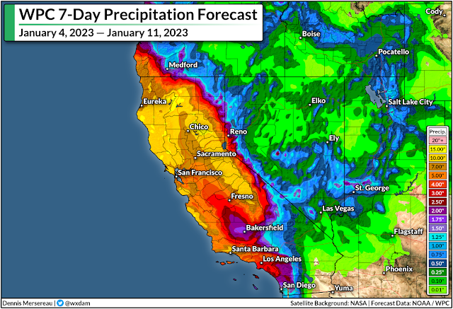
The WPC's latest precipitation outlook for the next seven days shows 10-15+ inches of rain falling on a huge swath of California through next week, with the heaviest precipitation focused on northern California and the mountains.
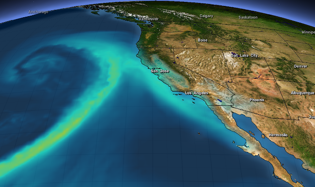
A continued train of storms will focus on California in the coming days, with about a day or two of spacing between each one. We're seeing this relentlessly wet pattern as a result of a powerful jet stream sagging pretty far down over the Pacific Ocean.
 |
| Source: Tropical Tidbits |
This jet isn't moving very much, so it has the opportunity to pump out one storm after another as each trough breaks at the end of the jet like a wave crashing on the beach.
Additional strong systems could reach the coast by this weekend, early next week, and late next week.
Remain mindful of the dangers of flash flooding. It's impossible to tell how deep the water is until it's too late. It takes surprisingly little moving water to lift up a vehicle and carry it away. Most freshwater flooding deaths in the U.S. occur when people drive their vehicles into deep or moving waters. Sometimes, especially in a hilly state like California, the road may be completely washed out under the water.
If you're under a wind advisory or high wind warning, you're at risk for power outages. It'll take crews longer to restore power during bad weather.
Make sure you've got batteries and flashlights on hand so you can see in the dark without wasting your cell phone battery on the flashlight feature. Rechargeable cell phone battery packs are also a great investment—they're relatively cheap now and most can provide one or two boosts to a smartphone's charge.


Hey, Dennis gets to write about my state for once...oh, wait, that's not good. ;^)
ReplyDelete