January 13, 2025

Southern California faces another 'particularly dangerous situation' fire risk this week


Another round of high winds with very low humidity levels prompted forecasters to issue a 'particularly dangerous situation' (PDS) red flag warning for portions of Los Angeles and Ventura Counties through much of Tuesday and Wednesday.

We'll see another Santa Ana wind event develop across portions of southern California beginning early Tuesday morning and continuing through Wednesday afternoon. Wind gusts of 55-70 mph are possible in some areas. While this isn't quite as severe as the Santa Ana wind event we saw last week, it's more than enough to fuel extreme fire behavior throughout the region.

“Areas in the red flag warning (especially during the PDS time frame) will have a high risk for large fires with very rapid fire spread, extreme fire behavior, and long range spotting," the National Weather Service said in its red flag warning on Monday.

The high-risk nature of this event prompted forecasters to add the wording "particularly dangerous situation" to the red flag warning draped across the region. This phrase, which is more commonly seen during severe thunderstorm outbreaks, emphasizes the threat to life and property posed by any fires that spark during these favorable conditions.

Santa Ana winds develop when high pressure to the east forces winds to blow up and over the Transverse Ranges that border the Los Angeles basin. These winds warm up and dry out as they descend the mountains and rush toward the coast, helping foster the rapid spread of ongoing fires as well as the easy ignition of new blazes.

Two major fires continued to burn throughout the Los Angeles metro area to start the week.

The Palisades Fire, located just west of Santa Monica, grew to 23,713 acres as of Monday afternoon, with the blaze only 13 percent contained.

The Eaton Fire, located just north of Pasadena, grew to 14,117 Acres as of Monday afternoon with crews managing to bring it to about 33 percent containment.

A resurgence of high winds and low humidity will likely fuel the growth and spread of these fires over the next couple of days—not to mention any additional fires that may spark during the red flag warnings.

Please remain alert for rapidly changing conditions over the next couple of days if you're in an area prone to wildfires. Take extra care not to engage in any activities that could accidentally spark an out-of-control blaze, including stuff like flicking cigarettes on the ground and parking your vehicle on dry grass.


Follow me on Facebook | Bluesky | Instagram

Get in touch! Send me an email.

Please consider subscribing to my Patreon. Your support helps me write engaging, hype-free weather coverage—no fretting over ad revenue, no chasing viral clicks. Just the weather.


December 9, 2024

Southern California's fire threat Monday night is a 'particularly dangerous situation'


The fire danger growing across parts of southern California is a "particularly dangerous situation," forecasters warned on Monday. 

Santa Ana winds expected to roar over the region will intensify Monday night into Tuesday, potentially fostering "extreme and life-threatening fire behavior" throughout the region.

A strong air pressure gradient building over southern California will spark a classic Santa Ana wind event, which features strong winds rushing over the coastal mountains toward the Pacific Ocean. These winds force air to warm up and dry out significantly as it rushes toward lower elevations.

Strong winds and low humidity are a perfect combination for the rapid ignition and spread of wildfires throughout the affected areas.


"Due to the expected long duration of dangerous fire weather conditions and critically dry fuels, there is the increasing potential for any new ignitions to have very rapid fire spread and extreme fire behavior (including long range spotting)," the NWS office in Los Angeles said on Monday.

The agency added: "As a result, there is the increasing threat for fire weather conditions to rival other historical fires in recent times including the Mountain and Thomas Fires."

Forecasters expect wind gusts of 50-80 mph to build across the region, with the greatest fire threat existing between 10:00 p.m. Monday through 2:00 p.m. Tuesday. 

The high-risk nature of this event prompted forecasters to add the wording "particularly dangerous situation" to the red flag warning draped across the region. This phrase, which is more commonly seen during severe thunderstorm outbreaks, emphasizes the threat to life and property posed by any fires that spark during these favorable conditions.

Please remain alert for rapidly changing conditions over the next couple of days if you're in an area prone to wildfires. Take extra care not to engage in any activities that could accidentally spark an out-of-control blaze, including stuff like flicking cigarettes on the ground and parking your vehicle on dry grass.


Follow me on Facebook | Bluesky | Instagram

Get in touch! Send me an email.

Please consider subscribing to my Patreon. Your support helps me write engaging, hype-free weather coverage—no fretting over ad revenue, no chasing viral clicks. Just the weather.


August 18, 2023

First-ever tropical storm watch issued for southern California, flash flooding likely

The National Hurricane Center issued its first-ever tropical storm watch for southern California on Friday as Hurricane Hilary continues to gather steam in the eastern Pacific Ocean.

The storm is closing in on scale-topping strength, clocking maximum sustained winds of 145 mph as of the agency's mid-morning update. Hilary is a high-end category four hurricane on the Saffir-Simpson wind scale.

Source: NOAA

It's this formidable strength—and a steady increase in its forward speed—that will give it the momentum needed to survive interaction with land and colder waters to survive into southern California as a tropical storm late this weekend.


Tropical storm watches are in effect for the Los Angeles and San Diego metro areas, as well as Orange County and many locations throughout inland southern California. Winds of 40+ mph are possible alongside the drenching rains, which will likely lead to tree damage and power outages throughout the region.


While the storm will weaken considerably by the time it enters the southwestern United States, it's going to bring a tremendous surge of tropical moisture inland, fueling the risk for prolific rains and catastrophic flash flooding for many vulnerable areas.

We're on track to see widespread rainfall totals of 3-5+ inches through early next week, much of which will fall over deserts and mountains that can't handle downpours that produce a fraction that much rain. Significant and widespread flash flooding is expected throughout the region, along with landslides across vulnerable terrain.

I talked a bit more in yesterday's post about why Hilary is so unusual and what's behind its track toward southern California. If the forecasts hold, this will be a first in living history.


But the fact that this is a rare storm following a rare track is almost secondary to the mammoth flooding threat that's likely to unfold whether or not Hilary makes it to U.S. soil at tropical storm strength. Even if the storm weakens, that vast reserve of moisture aloft isn't going anywhere. This rain is coming. The bullseyes may shift with the storm's track, but much of southern California, southern Nevada, and western Arizona is on track for a copious amount of tropical rains through early next week.

If you live in the region, please take the watches and warnings seriously, and heed the advice of local officials if they issue evacuations in flood-prone areas. Flooding is the single deadliest hazard in any landfalling tropical system.

Never try to drive across a flooded roadway. It's impossible to tell how deep the water is until it's too late, and the road may have been washed out beneath the floodwaters. It takes very little moving water to lift a vehicle and carry it downstream. The vast majority of flooding deaths occur in vehicles, and they're almost always preventable if the driver didn't attempt to ford the water.

Updated at 5:45 p.m. EDT to reflect that the tropical storm watch has been expanded to include Los Angeles.


Follow me on Facebook | Bluesky | Threads | Instagram | Twitter

Get in touch! Send me an email.

Please consider subscribing to my Patreon. Your support helps me write engaging, hype-free weather coverage—no fretting over ad revenue, no chasing viral clicks. Just the weather.


August 17, 2023

Southern California faces a serious flash flood threat with Hurricane Hilary


A serious flooding threat will likely develop across parts of California, Arizona, and Nevada beginning this weekend as Hurricane Hilary or its remnants track into the region through early next week.

Every once and a while, the meteorological factors align to make the improbable happen. A tropical system surviving long enough to approach southern California takes a multitude of ingredients falling together just right to come to fruition. 

Regardless of its 'official' title by the time it reaches California, Hilary or its remnants could bring significant, widespread, and life-threatening flooding to California, Arizona, and Nevada by early next week. Folks who live in flood-prone areas need to pay close attention to watches and warnings in the coming days.

Hurricane Hilary rapidly strengthening near Mexico


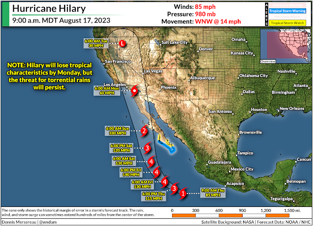
The National Hurricane Center expects Hilary to reach major hurricane status as it approaches the Baja Peninsula over the next couple of days. Forecasters call for the system to peak as a strong category four storm overnight Friday into Saturday morning before losing steam as it approaches cooler waters.

Hilary will begin picking up speed as it travels farther north, possibly making landfall on the Baja Peninsula on Sunday as it tracks toward southern California. The system—or its remnants—should cross the international border on Sunday night or Monday morning.

Even though Hilary will fall apart soon after landfall, the system's prolific tropical moisture will fuel torrential rains as its remnants push north through California, Arizona, and Nevada through early next week. 


Folks in the west don't see these NHC maps very often unless they're tracking weather back east. The forecast shows the predicted center of the storm at each time step over the next five days. The cone of uncertainty around the forecast points is the historical margin of error in the NHC's forecasts. A storm's center typically stays within that cone of uncertainty about two-thirds of the time.

Heavy rain and gusty winds usually extend hundreds of miles from the center of the storm, so when forecasters say "don't focus on the exact track of the storm," it's a silly-seeming reminder that storms are much larger than a single point on a map. 

What could happen across the Western U.S.

Far and away the greatest threat with this system will be torrential rainfall and widespread flash flooding. This outcome is likely whether or not Hilary reaches California as a tropical storm. 

The vast plume of tropical moisture lofted into the atmosphere by a hurricane doesn't just disappear when the storm starts to fizzle out. We'll see this tropical moisture surge inland across California, Arizona, and Nevada this weekend and continue through Monday and Tuesday.


Such a rich reserve of tropical moisture aloft acts like a reservoir for thunderstorms to tap into, allowing them to produce copious rainfall totals in a short period of time.

This kind of a situation would cause problems in areas where they're used to heavy rainfall. A setup like this across desert areas, urban development, mountains, and lingering burn scars will cause widespread flash flooding, landslides, and mudslides for the duration of the heavy rains.

We're likely going to see significant flooding throughout the region regardless of Hilary's status by the time it reaches the area. The greatest threat for flooding usually falls along the eastern side of a system's track, which would expose the deserts and mountains to the potential for 5+ inches of rain in a relatively short period of time.

Stay alert for watches and warnings if you live in a flood-prone area. Keep multiple routes in mind if you have to drive through areas expecting heavy rainfall. Never try to drive across a flooded roadway. It takes very little water for a vehicle to lose traction and float downstream. It's impossible to tell how deep the water is until it's too late, and the road is sometimes washed out beneath the floodwaters.

Why we're dealing with such an odd situation

Like a flipped quarter landing on its side, Hurricane Hilary seems to have everything working in its favor to bring significant impacts to California, Arizona, and Nevada by this weekend.

Source: NOAA

California almost entirely avoids tropical systems because upwelling off the coast keeps the sea surface here far too chilly to sustain a tropical system. Only two systems in the past century have reached Californian soil as tropical systems—Jennifer-Katherine in 1963, and Nora in 1997—both as weakening tropical depressions.

Nora is an especially interesting case, as it was a powerful hurricane that formed during a strong El Niño year and moved along a somewhat similar path as Hilary is expected to follow. The system tracked into the desert southwest as a tropical depression and brought tremendous flooding to the region as it pushed inland.

Tropical systems are rare enough here to count on one hand because the frigid ocean waters rob these systems of virtually all their energy, forcing them to fall apart in spectacular fashion.

However, it seems Hurricane Hilary is on track to exploit as many favorable factors as possible. It's going to run parallel to the Baja Peninsula, allowing the center of the storm to avoid cool water as much as possible.

Source: Tropical Tidbits

It's also riding around the edge of a significant ridge of high pressure building over the middle of the United States. This is the 'heat dome' you've probably heard will roast much of the country east of the Rockies through next week.

You don't even need to look at that upper-level map to see the ridge's influence...just look at the precipitation chart to see where it's going to be hot and sunny, and where all the storms and disturbances will ride the rim of the ridge. (Say that five times fast.)


This forecast from the Weather Prediction Center also does a great job highlighting how Hilary's remnant moisture will continue streaming over the northern Rockies and deep into Canada through next week.

[Satellite Image: NOAA]

Follow me on Facebook | Bluesky | Threads | Instagram | Twitter

Get in touch! Send me an email.

Please consider subscribing to my Patreon. Your support helps me write engaging, hype-free weather coverage—no fretting over ad revenue, no chasing viral clicks. Just the weather.


March 13, 2023

Another Atmospheric River Hits California As New England Deals With A Nor'easter


Two major storms will bookend the country on Tuesday, bringing more flooding rains and prolific snows to California while New England deals with its strongest nor'easter of the season.

The Setup

A jet stream firmly parked over the southern half of the United States will set the stage for the two major systems we'll have to deal with over the next couple of days.

Out west, upper-level winds will funnel a rich plume of moisture straight into California. (Stop me if you've heard this one before.) This latest atmospheric river will fuel widespread heavy rains at lower elevations and very heavy snows for the Sierra Nevada.

Back east, the combined lift of a trough digging across Eastern Canada and that strong jet stream over the southeastern U.S. will lead to the rapid development of a low-pressure system off the Mid-Atlantic coast late Monday evening.

This low will spin itself up in a hurry, likely meeting the criteria for bombogenesis, or a "bomb cyclone" as you'll probably hear it termed. This just means that the storm's minimum pressure will deepen very quickly, leading to wicked winds and widespread heavy snowfall across much of New England.

More Flooding For California

A weather alerts map of California today looks like a toddler went at it with a fresh pack of Crayola and a vivid imagination. The state is blanketed with flood watches, wind advisories, high wind warnings, and winter storm warnings for the mountains.

Source: NWS

Wind gusts could reach 50 mph for much of the northern half of California through Wednesday, with gusts up to 70 mph possible along the coastline and elevations above 1,000 feet. Those winds could easily lead to downed trees and power outages, especially with soils soaked from all the rain over the past couple of weeks.

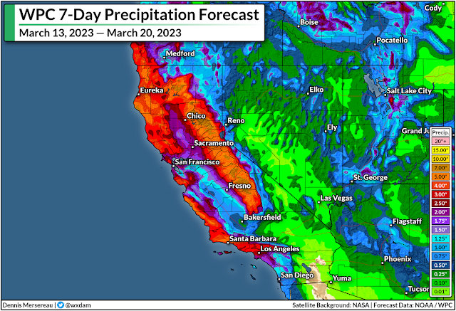
There's plenty more rain where that came from. The latest forecast from the Weather Prediction Center paints widespread rainfall totals of 3-5 inches along the coast, with up to 2.5 inches in the Central Valley and higher totals up north. Much of that precipitation in the mountains will fall as snow, with five feet of additional snow possible above 8,000 feet. 


This latest slug of rain and snow will add further stress to the region's waterways, many of which already spilled over their banks with the round of precipitation a few days ago.

As always, stay alert for flooding and be prepared to change your travel route if you come across a flooded road. It's impossible to tell how deep the water is until it's too late, and it only takes a few inches of moving water to lift a vehicle and carry it downstream. California's hilly terrain increases the odds that there may not even be a roadway left under the floodwaters.

Heavy Snow And High Winds For New England

Meanwhile, the East Coast will soon deal with a storm that could be its most significant thump (in fact, one of its only bouts) of wintry weather this year.

A classic nor'easter will spin up off the East Coast tonight and roar through early Wednesday morning, targeting much of New England with heavy snow and high winds for the day Tuesday.


The storm will really get cranking early on Tuesday morning, plastering almost everyone from northeastern Pennsylvania to coastal Maine with double-digit snowfall totals by the time the storm is over on Wednesday.

Most of the snow will fall north and west of I-95, sparing Philly and New York from much more than a dusting at best. Higher elevations in upstate New York could see up to two feet of snow.

Boston is going to be right on the borderline between a nuisance and a solid storm, with about 6-8 inches of snow in the forecast right now—with much lower totals just east and much higher totals just west. It wouldn't take much of a nudge in the storm's ultimate track to push that fine line in either direction. I don't admire local meteorologists up there right now.

Strong winds of 50-60 mph are likely during the storm, which will lead to tree damage and power outages for many location. This is going to be a wet, sloppy snow, to boot, which will weigh down trees and power lines and make damage and outages even more likely. Coastal flooding is also possible.

Heavy snowfall rates and high winds will lead to reduced visibility during the height of the storm, with whiteout conditions possible at times. If you have to travel through the area, it'd be a good idea to get where you need to go by Monday night and plan to stay put for a couple of days. 

[Top Image: Tropical Tidbits]


You can follow me on Facebook, Mastodon, Twitter, Instagram, or send me an email.

Please consider subscribing to my Patreon. Your support helps me write engaging, hype-free weather coverage—no fretting over ad revenue, no chasing viral clicks. Just the weather.


January 4, 2023

California Flood Risk Ramps Up As Another Atmospheric River Washes Over West Coast


Widespread heavy rain, high winds, and many feet of mountain snows are on the way to California over the next couple of days as another powerful storm swirls off the coast.

This latest wash of heavy rain will lead to a heightened flood risk for much of coastal California, with many communities still cleaning up the damage from the prolific rains that fell over the weekend.

We're in the midst of an exceptionally unsettled stretch of weather across the West Coast as a series of potent low-pressure systems take aim at the region.

This week's atmospheric river will bring the risk for several inches of rain across a wide swath of coastal California. The Sierra Nevada will see very heavy snow, with areas above 5,000 feet piling up multiple feet of snow over the next few days.

Source: NWS/WPC

The Weather Prediction Center (WPC) issued a moderate risk for excessive rainfall for much of the day Wednesday. This means that there's at least a 40 percent chance of rain exceeding flash flood guidance, or rain falling fast enough to trigger flash flooding in certain areas. Moderate risks don't come around too often, so that's a strong sign that vulnerable areas will see dangerous conditions.

We'll see high winds accompany the heavy rainfall through Thursday. Much of California is plastered in high wind warnings as gusts will reach 40-60 mph in most areas. Higher elevations could see gusts up to 70 mph at times. Since the ground is soaked from recent and ongoing rains, the winds will likely lead to tree damage and power outages in spots.


It's not over once this storm moves along, either.

The WPC's latest precipitation outlook for the next seven days shows 10-15+ inches of rain falling on a huge swath of California through next week, with the heaviest precipitation focused on northern California and the mountains.

A continued train of storms will focus on California in the coming days, with about a day or two of spacing between each one. We're seeing this relentlessly wet pattern as a result of a powerful jet stream sagging pretty far down over the Pacific Ocean.

Source: Tropical Tidbits
This jet isn't moving very much, so it has the opportunity to pump out one storm after another as each trough breaks at the end of the jet like a wave crashing on the beach.

Additional strong systems could reach the coast by this weekend, early next week, and late next week.

Remain mindful of the dangers of flash flooding. It's impossible to tell how deep the water is until it's too late. It takes surprisingly little moving water to lift up a vehicle and carry it away. Most freshwater flooding deaths in the U.S. occur when people drive their vehicles into deep or moving waters. Sometimes, especially in a hilly state like California, the road may be completely washed out under the water.

If you're under a wind advisory or high wind warning, you're at risk for power outages. It'll take crews longer to restore power during bad weather.

Make sure you've got batteries and flashlights on hand so you can see in the dark without wasting your cell phone battery on the flashlight feature. Rechargeable cell phone battery packs are also a great investment—they're relatively cheap now and most can provide one or two boosts to a smartphone's charge.

[Top image created using WSV3]

You can follow me on Facebook, Mastodon, Twitter, Instagram, or send me an email.

Please consider subscribing to my Patreon. Your support helps me write engaging, hype-free weather coverage—no fretting over ad revenue, no chasing viral clicks. Just the weather.


September 5, 2022

All-Time Heat Records Fall As Major West Coast Heat Wave Continues


A historic heat wave over the West Coast that's shattered longstanding daily, monthly, and all-time records is going to stick around for a while longer.

If the observations are valid, Sacramento International Airport's high temperature of 117°F on Monday afternoon is the hottest temperature ever recorded in California's state capital. The previous all-time record high was 115°F on June 15, 1961.

SOURCE: NWS

This is an unprecedented heat wave for folks out west. It's obvious that this is a high-end heat wave for the western United States, but the fact that this is happening in September is almost more unusual than the temperatures themselves.

Take a look at this animation (from coolwx.com) showing all of the temperature records broken over the 24 hours between Sunday evening and Monday evening:

SOURCE: coolwx.com

All of the pink dots nestled inside of a white circle are all-time monthly records—the hottest temperatures ever recorded in the month of September.

The circles with a big black X are the hottest temperatures ever recorded at that station. Look closely at the end of the animation to see multiple X marks pop up over California.

This heat isn't over yet. Tuesday will see another day of record-breaking temperatures across the western United States.

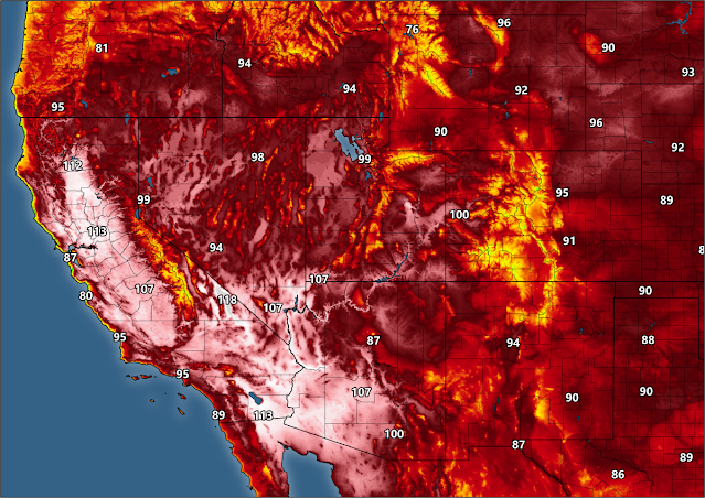
Here are the National Weather Service's predicted high temperatures for Tuesday:


A historic heat event is bad enough on its own, but there are three factors exacerbating the impacts of this particular nightmare.

1) it's been hot for a long time, and it'll be hot for a while yet. The heat will stick around through the end of the week for many spots as this powerful ridge of high pressure remains parked west of the Rockies;

2) excessively hot days are bad enough, but low temperatures at night aren't providing much relief to folks who don't have adequate means of cooling off. The compounding stress of hot days and stifling nights can (and will) lead to medical emergencies and possible fatalities;

3) and the fact that it's not exactly a dry heat, especially in southern California. The dew point is in the 60s for many folks in the Los Angeles area, for instance, which is muggy anywhere, but especially for an area that's not used to a humid heat.


We'll finally see the ridge begin to break and weaken toward the end of the week as a result of Hurricane Kay in the eastern Pacific. This storm is on track to follow the Baja California Peninsula through the week, eventually slowing down and turning west by this weekend as it reaches the northern extent of the peninsula.

Of course, this is being spun into "A HURRICANE IS HEADING FOR CALIFORNIA!!!" by folks jonesing for sweet, sweet social media clout. Conditions are too unfavorable for just about any storm to make it to California as a tropical entity—that's why there's only something like one hurricane on record that's ever hit the state.

The system's moisture will reach southern California, though, and that'll bring some challenges of its own. Some spots could see several inches of rain next weekend amid the influx of tropical moisture. This would reduce temperatures, but it would also lead to a risk for flash flooding and mudslides, especially on and around burn scars.


It remains to be seen how far north into California we'll see the tropical moisture reach. A deeper push would provide a better chance for rain across areas that desperately need the relief right now. However, there's also a chance that this setup could lead to thunderstorms, leading to an increased potential for wildfires. This risk will crank up dramatically if these turn out to be dry thunderstorms.

Keep a close eye on the forecast heading into this weekend. As always, whether it's flooding or wildfires or any sort of disaster, make sure your emergency plans and supplies are taken care of long before your home is under threat.


You can follow me on Twitter or send me an email.

Please consider subscribing to my Patreon. Your support helps me write engaging, hype-free weather coverage—no fretting over ad revenue, no chasing viral clicks. Just the weather.


January 26, 2021

California Braces For Strong Adjectives As Rain, Snow, Wind Overspread State


A barrage of descriptive words will wash over California over the next couple of days as strong winds, heavy rain, and huge snows promise to do a number on the state's drought. While rain and snow are a  good thing, too much all at once can cause serious issues. Mammoth snowfall totals in the mountains will make travel impossible and lead to a high risk for avalanches, while heavy rain at lower elevations could trigger flash flooding and mudslides.

The Setup

A growing trough in the jet stream will continue to sharpen as it approaches the West Coast overnight into Wednesday. This trough, along with a cold front extending off a low-pressure system moving into the Pacific Northwest, will direct an atmospheric river right at California.
Source: Tropical Tidbits
Despite its name, an atmospheric river isn't something made up to sound good on a chyron. The term describes a narrow band of enhanced moisture in the atmosphere that flows from tropical latitudes to the middle latitudes. In this case, the atmospheric river will drag tropical moisture from the central Pacific and focus it over much of California over the next couple of days. 

The amount of moisture in the atmosphere plays a huge role in how much rain or snow can fall over a certain area. Rain showers, snow bands, and thunderstorms can tap into an atmospheric river like a reservoir and condense that rich moisture into a tremendous amount of precipitation.

The result will be impressive.

Snowfall


Source: NWS Sacramento

The National Weather Service's snowfall forecast for the highest peaks in the Sierra calls for 80 to 100 inches of snow by the end of the storm, with locally higher snowfall totals possible. Some areas could see more than 10 feet of snow by the time things calm down.

That much snow all at once will make travel all but impossible across roads that traverse the mountains, and it'll lead to a high risk for avalanches as much of the fresh snowpack will be unstable. It's not all bad, though. Mountain snowpack is a significant source of freshwater for many communities around California. This kind of snow will go a long way toward reinforcing some of that water supply after the region's slipped deeper into drought over the last year.

Rainfall


Lower elevations will experience rain—and plenty of it. Widespread rainfall totals of 3 to 6 inches are likely from western Washington straight down the coast through southern California. Higher elevations below the freezing line could see double-digit rainfall totals by the end of the storm. An inch or two of rain is possible all the way down in Los Angeles through this weekend.

This much rain falling this quickly will lead to a risk for flash flooding. The greatest risk for flash flooding will exist from about Monterey to San Luis Obispo, but a risk for excessive rainfall will exist from the Bay Area east to about Sacramento, and down the coast through Santa Barbara. 

Never try to drive across a flooded roadway. It only takes a couple of inches of fast-moving water to lift a vehicle and carry it downstream. It's impossible to judge how deep the water is until you're already in it. Sometimes, floodwaters can wash away the road and obscure the fact that there isn't a road there anymore until it's too late.

The risk for flash flooding and mudslides is greater around the region's many burn scars. Wildfires destroy the soil over which they burn, making the soil virtually impermeable. Since the water can't penetrate into the ground, it oversaturates the topsoil and triggers a mudslide. Debris flows, flash floods that carry ash, rocks, and burned vegetation, can destroy roads and buildings downstream from the loaded floodwaters.

Gusty Winds

If it's a storm in California, it's going to be windy. High winds are possible across much of the state through Wednesday. Wind gusts as high as 60 MPH in some areas could easily knock down trees and power lines, especially where heavy rain loosens the soil and makes it harder for trees and poles to stand up to the stress of the wind.

[Satellite Image: NOAA]


You can follow me on Twitter or send me an email.

Please consider subscribing to my Patreon. Your support helps me write engaging, hype-free weather coverage—no fretting over ad revenue, no chasing viral clicks. Just the weather.
 

January 18, 2021

High, Dry Winds Could Spark An Off-Season Fire Threat Across Parts Of California On Tuesday


A critical fire risk and life-threatening rip currents are possible across parts of California over the next couple of days as high winds begin to blow across the Golden State. High wind warnings are in effect for much of southern California, as well as high elevations in the Sierra and Bay Area, in anticipation of gusts that could exceed 60 MPH at times.

Source: PivotalWeather.com

A strong area of high pressure over the northern Rocky Mountains will push against a developing low-pressure system off the coast of southern California. The tight pressure gradient between the two systems will generate powerful offshore winds that will peak on Tuesday before tapering off on Wednesday night. 

The greatest risk for high winds will exist on Tuesday, when gusts could easily exceed 60 MPH in areas under a high wind warning. Winds that strong can do damage in their own right, knocking down trees, power lines, and blowing around loose objects in backyards and on patios.


Even though we're well outside of traditional fire season in California, which typically peaks in the fall months, the combination of several favorable ingredients will lead to potentially dangerous conditions for wildfire ignition and growth.

The Storm Prediction Center's latest fire weather outlook shows an elevated risk for fire weather conditions from the eastern Bay Area down to the border with Mexico, and a critical risk for fire weather conditions for higher elevations from San Luis Obispo to northern San Diego County.

A fire consumed a few hundred acres of land this weekend in Thousand Oaks, California, and a handful of small fires broke out near Sacramento on Monday. 

While it's unusual to have this kind of fire risk in the middle of January, it's not too much of a surprise given the predicted conditions across the region right now. Temperatures will climb above normal across the affected areas. The strong high-pressure system to the northeast will help generate those powerful winds that could spread any flames in a hurry.


And it's dry. Very dry. While the worst drought is farther inland toward the deserts and Intermountain West, almost the entire state of California is mired in some level of drought, according to last week's update of the United States Drought Monitor. Dry vegetation, low humidity, relatively warm conditions, and high winds are a breeding ground for fast-spreading fires.

As if the risk for tree damage, power outages, and wildfires wasn't enough, the strong winds will also lead to a high risk for rip currents off beaches up and down the state's coastline. A rip current is a swift current of water that pulls away from the beach, generated by waves that hit the beach head-on.

Rip currents are dangerous not because they suck you underwater—that's just made-for-TV dramatics—but because they quickly pull you away from the coastline. The vast majority of injuries and deaths in rip currents are caused by the victim panicking or quickly becoming exhausted trying to swim against the current to get back to shore. 

The best practice, of course, is to avoid going in the ocean when there's a risk for rip currents. If you ever find yourself caught in a rip current, tread water and calmly signal for help. If you're not a strong swimmer, tread water until help arrives or the rip current releases you so you can paddle back to shore. It will eventually release you. If you're able to swim, don't try to swim against the current—it's too strong. You need to swim parallel to the coastline until you're out of the current, and then swim back to the beach.


You can follow me on Twitter or send me an email.

Please consider subscribing to my Patreon. Your support helps me write engaging, hype-free weather coverage—no fretting over ad revenue, no chasing viral clicks. Just the weather.