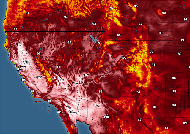
If the observations are valid, Sacramento International Airport's high temperature of 117°F on Monday afternoon is the hottest temperature ever recorded in California's state capital. The previous all-time record high was 115°F on June 15, 1961.
 |
| SOURCE: NWS |
This is an unprecedented heat wave for folks out west. It's obvious that this is a high-end heat wave for the western United States, but the fact that this is happening in September is almost more unusual than the temperatures themselves.
Take a look at this animation (from coolwx.com) showing all of the temperature records broken over the 24 hours between Sunday evening and Monday evening:
 |
| SOURCE: coolwx.com |
All of the pink dots nestled inside of a white circle are all-time monthly records—the hottest temperatures ever recorded in the month of September.
The circles with a big black X are the hottest temperatures ever recorded at that station. Look closely at the end of the animation to see multiple X marks pop up over California.
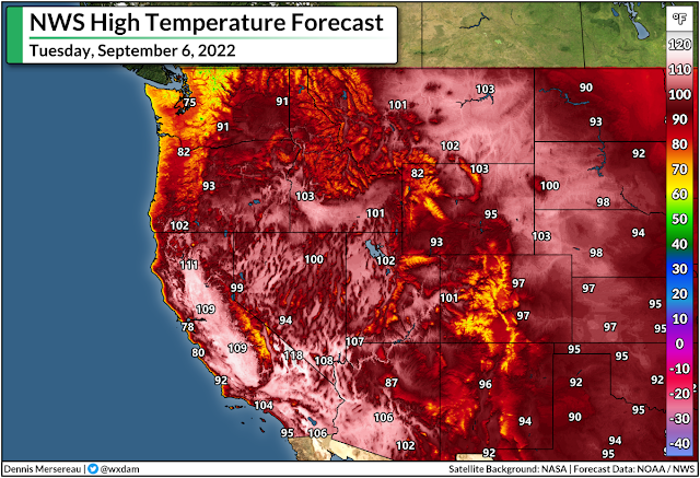
This heat isn't over yet. Tuesday will see another day of record-breaking temperatures across the western United States.
Here are the National Weather Service's predicted high temperatures for Tuesday:
A historic heat event is bad enough on its own, but there are three factors exacerbating the impacts of this particular nightmare.
1) it's been hot for a long time, and it'll be hot for a while yet. The heat will stick around through the end of the week for many spots as this powerful ridge of high pressure remains parked west of the Rockies;
2) excessively hot days are bad enough, but low temperatures at night aren't providing much relief to folks who don't have adequate means of cooling off. The compounding stress of hot days and stifling nights can (and will) lead to medical emergencies and possible fatalities;
3) and the fact that it's not exactly a dry heat, especially in southern California. The dew point is in the 60s for many folks in the Los Angeles area, for instance, which is muggy anywhere, but especially for an area that's not used to a humid heat.
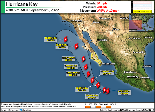
We'll finally see the ridge begin to break and weaken toward the end of the week as a result of Hurricane Kay in the eastern Pacific. This storm is on track to follow the Baja California Peninsula through the week, eventually slowing down and turning west by this weekend as it reaches the northern extent of the peninsula.
Of course, this is being spun into "A HURRICANE IS HEADING FOR CALIFORNIA!!!" by folks jonesing for sweet, sweet social media clout. Conditions are too unfavorable for just about any storm to make it to California as a tropical entity—that's why there's only something like one hurricane on record that's ever hit the state.
The system's moisture will reach southern California, though, and that'll bring some challenges of its own. Some spots could see several inches of rain next weekend amid the influx of tropical moisture. This would reduce temperatures, but it would also lead to a risk for flash flooding and mudslides, especially on and around burn scars.
It remains to be seen how far north into California we'll see the tropical moisture reach. A deeper push would provide a better chance for rain across areas that desperately need the relief right now. However, there's also a chance that this setup could lead to thunderstorms, leading to an increased potential for wildfires. This risk will crank up dramatically if these turn out to be dry thunderstorms.
Keep a close eye on the forecast heading into this weekend. As always, whether it's flooding or wildfires or any sort of disaster, make sure your emergency plans and supplies are taken care of long before your home is under threat.
You can follow me on Twitter or send me an email.
Please consider subscribing to my Patreon. Your support helps me write engaging, hype-free weather coverage—no fretting over ad revenue, no chasing viral clicks. Just the weather.
Please consider subscribing to my Patreon. Your support helps me write engaging, hype-free weather coverage—no fretting over ad revenue, no chasing viral clicks. Just the weather.


0 comments: