‘Catastrophic’ Hurricane Ian Making Landfall In Southwestern Florida
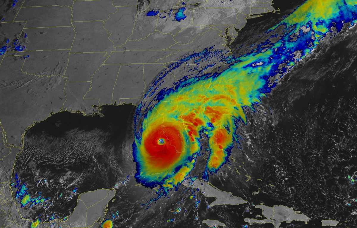
Hurricane Ian was one sneeze away from category five intensity as it careened into southwestern Florida on Wednesday.
The storm’s rapid intensification over the steamy waters of the southern Gulf of Mexico saw Ian grow into a high-end category four hurricane with maximum winds of 155 mph. Forecasters at the National Hurricane Center (NHC) expect the storm to more or less maintain this strength as it pushes into the southwestern Florida coast through the day on Wednesday.

This is going to be a catastrophic storm for the region on a level that could easily surpass the devastation wrought by Hurricane Charley back in 2004. Former NHC Director Dr. Rick Knabb tweeted Wednesday morning that the entire extent of Charley’s hurricane-force winds could comfortably fit within Ian’s eye with room to spare.
Ian is a much larger and stronger storm than Charley was, and its destructive reach will spread over a much larger portion of Florida over the next couple of days.
Storm Surge
A devastating double-digit storm surge will push into southern Florida near where the hurricane makes landfall tonight. This is particularly terrifying for Charlotte Harbor and the mouth of the Caloosahatchee River, putting communities like Cape Coral, Fort Myers, and Punta Gorda at risk of a 12+ foot storm surge.
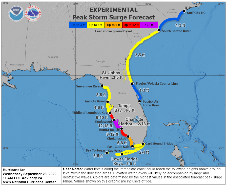 |
| SOURCE: NHC |
A storm surge on this magnitude will push very far inland, compounding the destruction. Thousands upon thousands of homes could be completely flooded out by this storm surge. Anyone who chose to remain at home (or didn’t have the means to evacuate) will be at grave danger when the surge rushes in as Ian makes landfall on Wednesday night.
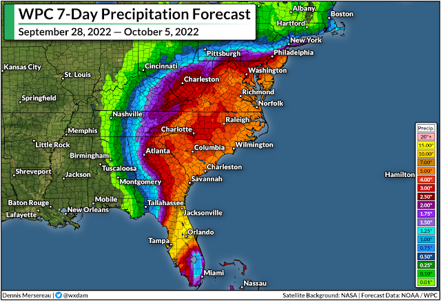
Flooding Rains
Hurricane Ian’s ferocious winds are only part of this storm’s danger. This will be remembered as a water storm as much as it’ll be remembered for its destructive winds.
Florida will endure widespread flooding over the next couple of days as this slow-moving hurricane drops one to two feet of rain across the middle of the state. This much rain will inundate natural and man-made drainage systems, leading to flooding even in areas that don’t typically flood during torrential rainfall.
The combination of wind damage, coastal storm surge, and inland flooding will stress local resources to their limit. Widespread water rescues are likely in the hardest-hit areas, and emergency officials may not be able to assist people whose homes are flooding during the storm’s high winds.
The risk for flooding isn’t just limited to Florida. Widespread heavy rain will push into the interior southeast as Ian pushes inland through this weekend.
As I explained in Sunday’s post, Ian is encountering a complex setup that will allow the storm to wring out drenching rains on the southeast. We’ll see widespread rainfall totals of 3-6+ inches across the region, which will lead to a risk for flash flooding as far inland as the Appalachians in Virginia.
Winds/Tornadoes
Storm surge and freshwater flooding from prolific rainfall will cause significant and costly damage to the region, but we can’t ignore the risk for wind damage. The eyewall is scraping some heavily populated areas. We’re going to see widespread structural damage, tree blowdowns, and heavy damage to the power grid as this storm pushes ashore.
An extreme wind warning is in effect for Cape Coral FL, Bonita Springs FL, Estero FL until 12:45 PM EDT for extremely dangerous hurricane winds. Treat these imminent extreme winds as if a tornado was approaching and move immediately to an interior room or shelter NOW!. pic.twitter.com/Noc5LcsZIt
— NWS Tampa Bay (@NWSTampaBay) September 28, 2022
The wind threat doesn’t stop at the coast. Hurricane warnings span the Florida Peninsula, with hurricane conditions expected all the way into the Orlando metro area as Ian pushes inland.
Forecasters expect Ian to reemerge in the Atlantic Ocean before making another landfall near the Georgia/South Carolina border.
This secondary landfall will bring tropical storm/near hurricane conditions to coastal sections of Georgia and South Carolina, where hurricane watches and tropical storm warnings are in effect. There’s a chance Ian could regain hurricane strength before making landfall again on Friday.
Tornadoes are also a big concern for the Florida Peninsula and coastal Carolinas as Ian makes its way through the region over the next couple of days.
You can follow me on Twitter or send me an email.
Please consider subscribing to my Patreon. Your support helps me write engaging, hype-free weather coverage—no fretting over ad revenue, no chasing viral clicks. Just the weather.


