July 28, 2025

Tampa, Florida, hits 100°F for the first time in 135 years of records


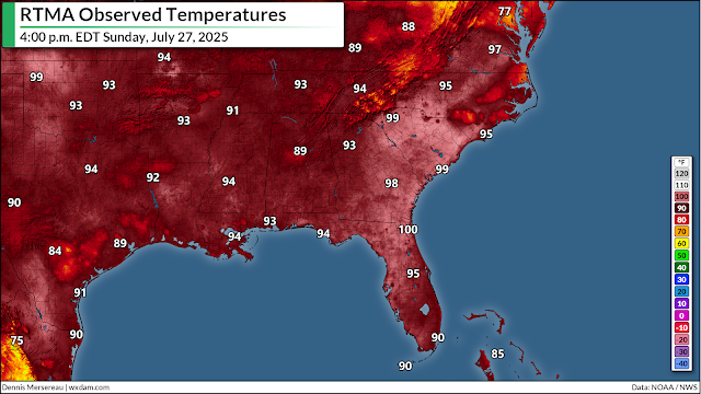
Folks in Tampa, Florida, endured the city's hottest day in weather history on Sunday when the temperature at Tampa International Airport reached 100°F at 3:30 p.m. local time. 

The feat arrived as a long-duration heat event roasted much of the eastern United States—with a strong focus on the southeast. Charlotte, North Carolina, for instance, hit 101°F on Saturday, 102°F on Sunday, and they were well on their way to the triple-digits as of this post on Monday afternoon. 

A multi-day heat event isn't unusual for this part of the country during the heart of summer. But it unusual for folks on the Florida peninsula—especially right on the water—to reach the century mark. 


Tampa's previous all-time record high temperature was 99°F set on both June 26, 2020, and June 5, 1985. Weather records in the city date back to April 1, 1890, threaded across various locations. The main observation station has been at the Tampa International Airport since February 1, 1939, and the station currently sits about 2,800 feet from the waters of Tampa Bay

One of the big questions I've seen in the wake of this 135-year-old weather record is "why is the all-time high temperature so low?"

After all, plenty of cities to the north hit 100 degrees at least once or twice per summer. Washington's all-time high temperature is 105°F. Boston hit 103°F back in July 2011. 

It's (almost) all in the humidity. Exceptionally muggy air bathes Florida for most of the year. Air rich with water vapor resists heating up just as it resists cooling down at night. This mugginess moderates how high temperatures can rise on a steamy Florida afternoon, limiting how high the mercury can rise even during a formidable heat wave.

Another major factor at play on Sunday was the wind direction. Tampa Bay is west of the airport's weather station. Winds on Sunday afternoon were blowing out of the north and northeast—so instead of a cooling sea breeze, they were feeling light winds travelling over land instead of the cooler waters nearby. 

Graphic courtesy of Climate Central

It's worth pointing out that the low temperature only dipped to about 84°F on Sunday night and Monday morning. As much as humidity limits how hot an afternoon can grow, it also limits how much conditions can cool off at night. (I just recorded a segment for The Weather Network about this!) 

Climate change is making matters worse. Warming temperatures combined with rising humidity have already led to muggier and more uncomfortable nights. The Tampa area has seen nighttime low temperatures rise more than 4 degrees since the 1970s, according to Climate Central.


Follow me on Facebook | Bluesky | Instagram

Get in touch! Send me an email.

Please consider subscribing to my Patreon. Your support helps me write engaging, hype-free weather coverage—no fretting over ad revenue, no chasing viral clicks. Just the weather.


January 22, 2025

Historic Gulf Coast winter storm was the region's worst in 130 years


A major winter storm blanketed the northern Gulf Coast on Tuesday, Jan. 21, in the region's largest winter storm since February 1895. 

Roads, schools, and businesses were closed throughout the region as communities simply lacked the plows and road treatment equipment to deal with the onslaught of wintry weather. 

The system brought accumulating snow from eastern Texas through northwestern Florida, leaving behind a thicker blanket of snow than some towns have ever recorded.

The Benchmark: Blizzard of 1895

A mammoth snowfall back in 1895 remains the Gulf Coast's benchmark for a winter storm in the region. The Great Snowstorm of 2025 eclipsed that event in some spots. 
A weather map showing snow along the northern Gulf Coast the morning of Feb. 15, 1895. (NOAA)

That storm 130 years ago formed in a similar manner to the modern storm we dealt with this week: a cold snap covered the United States while a low-pressure system developed over the Gulf of Mexico.

The system back in 1895 brought tremendous snows to the region—Houston saw nearly 20 inches of accumulation, while New Orleans and Mobile each picked up about half a foot of snow. No storm since then has eclipsed those totals in Houston.

The Setup

The catalyst for the Jan. 2025 outburst of cold and snow ultimately started with a series of ridges of high pressure building over Alaska. 

Calling this an unusual pattern is an understatement. The ridge sent daytime highs soaring into the 40s across Alaska on Jan. 12. The high in Fairbanks that day climbed to 47°F, a day when their normal high temperature is supposed to be around -1°F. Temperatures remained well above normal for the following week as several more ridges built over the region.
An upper-level map showing the strong ridge over Alaska and the deep trough swooping over the U.S. on Jan. 19, 2025. (Tropical Tidbits)

These Alaskan ridges destabilized the polar vortex, an ever-present circulation of winds high above the Arctic. Frigid air remains confined to the highest latitudes when the polar vortex is stable. If it weakens and becomes unstable—like we saw last week—a lobe of the polar vortex can swoop southward and drag bitterly cold air along with it. 

About a week after the first big ridge peaked in intensity across Alaska, cold air began flooding south across Canada and into the United States. By Monday, Jan. 20, subfreezing temperatures made it as far as the Gulf of Mexico, setting the stage for the Gulf Coast's major winter storm. 

The Storm

The upper-level trough allowing that cold air to sink southward triggered the development of a low-pressure system over Texas late in the day on Monday. This rapidly developing system had free access to both frigid air to the north and Gulf moisture to the south. 


Snow and sleet began falling across eastern Texas late on Monday, spreading across the northern Gulf Coast through the overnight hours into Tuesday, Jan. 21. 

Heavy snow and gusty winds pushed into Louisiana early on Tuesday, prompting forecasters to issue the state's first-ever blizzard warnings for the southwestern corner of the state around Lake Charles. Snow fell on New Orleans most of the day Tuesday, bringing the city its first measurable snow in more than 15 years. 
A snowy scene on I-10 in Mobile, Alabama, on Jan. 21, 2025. (ALGoTraffic)

The system pushed heavy snow into southern Mississippi and southwestern Alabama through the day Thursday. Frigid temperatures allowed the snow to stick immediately and pile up in a hurry. Videos on social media showed people having snowball fights on the beach in Orange Beach, Alabama. The National Weather Service office in Mobile reported 16-inch drifts by Tuesday evening.

Temperatures were cold enough in northwestern Florida for an exceptionally rare snowfall to blanket the panhandle of the Sunshine State. Steady snow was reported in Pensacola, Destin, and Panama City Beach through Tuesday afternoon.
Orange Beach, Alabama on Jan. 21, 2025 (Orange Beach Police Department)

Warmer temperatures holding on through the mid-levels of the atmosphere allowed a messy mix of wintry precipitation to fall across the northern Florida Peninsula as the storm arrived on Tuesday evening. Accumulating sleet and freezing rain was reported in Jacksonville, with a winter weather advisory in effect as far south as Ocala.

The Totals

We saw historic snowfall totals across the northern Gulf Coast from this storm.


Folks in eastern Texas got a solid snow day out of the event. Beaumont came in 5.5 inches of snow, Houston saw about 3.5 inches, and even the city of Galveston picked up about an inch. 

Some parts of Louisiana saw eye-popping totals from the storm. Lafayette saw about 10 inches of snow, corroborated by several nearby communities that saw reports of 8-10 inches of accumulation. 

New Orleans measured its largest snowfall in recorded history. The 8.0 inches recorded at the city's airport beat the half-foot total reported during that historic storm back in 1895. The previous record at the city's airport was 2.7 inches recorded back on Dec. 31, 1963.


Mobile, Alabama, saw its largest snowstorm in recorded history. The city picked up more than half a foot of snow from the storm, topping out with 7.5 inches by Tuesday night. This eclipses the official record of 3.6 inches measured at the airport in Feb. 1973, and it beats the historic snowstorm of Feb. 1895 which dropped about 6 inches of snow in the city.

The entire state of Florida's all-time snowfall record likely fell during this storm. Forecasters received a report of 9.5 inches of snow in Molino, Florida, in the northwest corner of the state north of Pensacola. A retired NWS employee in Milton, Florida, reported 8.8 inches of snow—which would break the statewide snowfall record in its own right. 

Pensacola also saw its largest snowfall on record. The city's biggest storm in recent history dropped 2.3 inches of snow back on Mar. 6, 1954. Pensacola saw 6-8+ inches this time around—eclipsing that previous record.

A swath of 2-5 inches of snow fell across the rest of the Florida Panhandle east toward Tallahassee, an exceptionally rare event that may not happen again for decades.


Clear skies and a thick snowpack allowed for some of the coldest temperatures ever recorded in the region by Wednesday, Jan. 22.

The preliminary low temperature in Lafayette, Louisiana, dipped all the way down to 4°F on Wednesday morning, which would be the coldest temperature ever recorded there. The previous all-time cold record was a 7°F reading back on Feb. 13, 1899. 

Mobile dropped to 7°F on Wednesday morning, only the 8th morning with a single-digit low temperature since records began at KMOB airport back in 1948. The all-time coldest temperature at the Mobile Regional Airport remains a 3°F reading on Jan. 21, 1985. (The city's all-time low was -1°F recorded during that cold outbreak in Feb. 1899.)

[Top image taken by the Walton County Sheriff's Department]


Follow me on Facebook | Bluesky | Instagram

Get in touch! Send me an email.

Please consider subscribing to my Patreon. Your support helps me write engaging, hype-free weather coverage—no fretting over ad revenue, no chasing viral clicks. Just the weather.


August 29, 2023

Destructive winds, widespread flooding likely far inland as Hurricane Idalia makes landfall


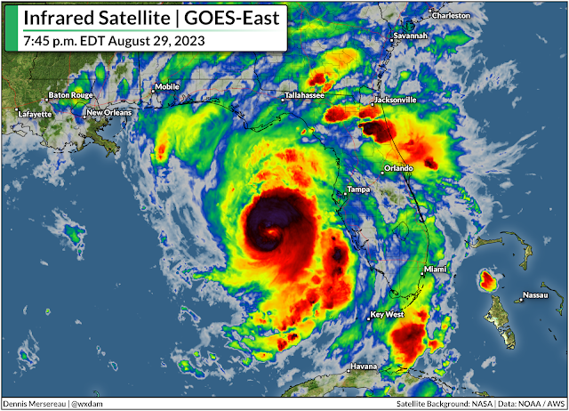
Hurricane Idalia is picking up speed toward northern Florida on Tuesday night as the storm continues to grow in strength and size over the sultry waters of the eastern Gulf of Mexico.

This is a deadly serious threat for coastal communities in the path of the storm, many of which have not witnessed a storm this powerful in the region's living memory.

While the coastline faces the life-threatening prospect of 10+ feet of storm surge and the full force of a major hurricane, this storm's impacts will extend far inland. This is not just a coastal threat, and these far-reaching storms often catch folks off-guard when they're hundreds of miles from the point of landfall. That's what I'll focus on here.

The storm's destructive winds, widespread flooding, and tornadoes will extend far inland from the point of landfall, exposing a large swath of northern Florida and coastal sections of Georgia and the Carolinas to significant and potentially long-lasting impacts from this powerful storm.


Hurricane Idalia spent Tuesday taking advantage of a favorable environment to rapidly intensify as it heads toward the western coast of Florida. The storm's maximum sustained winds crossed 100 mph on Tuesday afternoon, with the National Hurricane Center (NHC) expecting the Idalia to make landfall early Wednesday morning as a major hurricane.

The storm is likely to intensify all the way up to landfall, which could mean its maximum winds could climb to 120 mph or higher by the time the eyewall crosses the marshy coastline of Florida's Big Bend, likely near the community of Cedar Key.

Conditions will go downhill in a hurry as Tuesday night settles in, and the hurricane's high winds and drenching rain will quickly push ashore through the overnight hours as the storm makes landfall early Wednesday morning.

High winds and power outages

Idalia's ferocious winds, increasing speed, and the marshy terrain in the hurricane's path will allow the storm to maintain its intensity as it pushes inland through the day Wednesday.

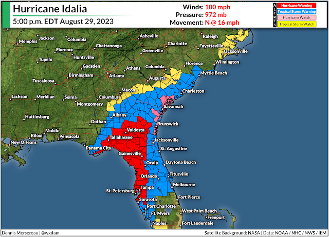
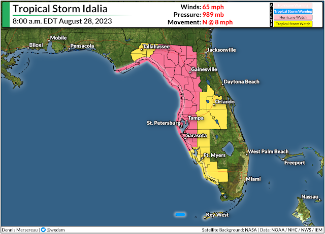
Destructive winds are likely across much of northern Florida and southern Georgia, where hurricane warnings are in effect from Tampa to Tallahassee and north past Valdosta. Tropical storm warnings extend even farther inland, covering most of northern Florida—including Orlando and Jacksonville—as well as southeastern Georgia and all of coastal South Carolina.


Winds of 120+ mph will push into Florida's Apalachee Bay, which has seen exactly zero major hurricanes in recorded history. NWS Tallahassee is stressing that this is an unprecedented event for the region, and it's likely going to be the strongest hurricane to affect Tallahassee proper in living memory.

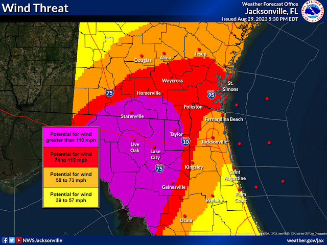
Given the marshy terrain and swift forward motion, it'll take a while for Idalia to lose steam. Sustained winds of 75+ mph are likely well into southern Georgia during the day Wednesday. Sustained winds of 60 mph will likely follow the storm all the way to Charleston, South Carolina, by the overnight hours Wednesday into Thursday.

Such a widespread wind event will lead to a significant blowdown of the dense forests that cover this portion of the southeastern United States. Expect many impassable roads for days after the storm, especially smaller and less-travelled roads. 

Source: NWS

Hundreds of thousands of homes and businesses will remain without power for many days after the storm, with the worst-hit areas likely going without electricity for several weeks as crews quite literally rebuild the power grid.

These widespread power outages will be a major disruption for folks who live in the region.

Communities that experience prolonged blackouts will see their perishable foods spoil and few options to buy groceries or other necessary supplies. Cooking will be extremely difficult without natural gas, propane, or outdoor grills. Tap water may require boiling—or stop running altogether—if water lines are damaged or municipal providers lose power themselves.

In addition to the basic supplies like water, food, and hygiene products, flashlights and batteries are an essential resource. The flashlight feature on your phone is the easiest way to kill your battery, which is a scary prospect in a lengthy power outage.

Widespread flash flooding

The number one cause of death in any landfalling tropical system is flash flooding from heavy rains, and most of those flood-related deaths occur in vehicles.


Forecasters expect 5-7+ inches of rain to fall along Idalia's path as it cuts from Florida to South Carolina. This glut of drenching rain will likely cause flash flooding throughout the area, especially in flood-prone areas. There are always roads that flood in storms like this, and there are always people who try to ford the high water anyway.

It's impossible to tell how deep the water is until you're in it and it's too late. It only takes a small amount of standing water to lift a vehicle and carry it away, threatening the live of those in the vehicle and those who have to go rescue them or recover their bodies.

Tornadoes are likely through Thursday

Tornadoes are a hazard with any landfalling tropical system. Supercell thunderstorms are common in the outer bands of a storm as high instability and strong wind shear allow these tiny storms to spin like tops.


Tropical tornadoes happen quickly—sometimes touching down and lifting in between radar scans, only lasting a couple of minutes with very little tornado warning lead time. 

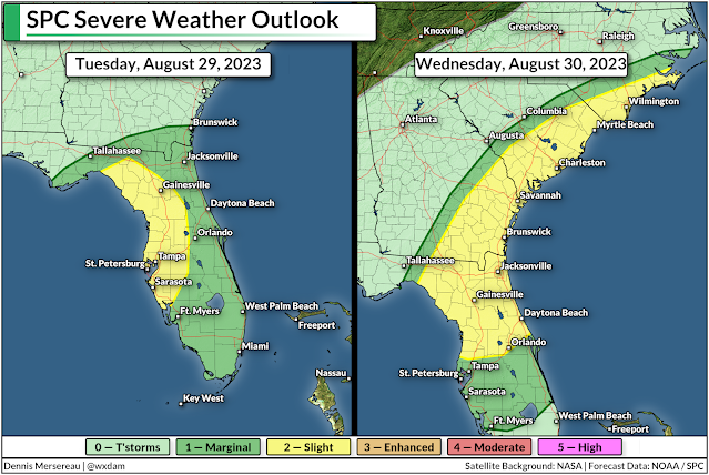
These tornadoes are most likely along and to the right of the storm's path, which places the greatest risk for tornadoes across the Florida Peninsula through Tuesday night into early Wednesday, and across coastal region of Georgia and South Carolina during the day Wednesday into early Thursday.

Take a look at your phone and make sure that wireless emergency alerts are turned on for tornado warnings. These free push alerts are proven lifesavers in tornadoes, and the screeching tone is likely to wake even the soundest sleeper.


Follow me on Facebook | Bluesky | Threads | Instagram | Twitter

Get in touch! Send me an email.

Please consider subscribing to my Patreon. Your support helps me write engaging, hype-free weather coverage—no fretting over ad revenue, no chasing viral clicks. Just the weather.


August 28, 2023

Idalia on track to hit Florida as a major hurricane Wednesday


Idalia could grow into a major hurricane as it aims toward western Florida by the middle of the week. The system "should keep strengthening up to landfall," according to the National Hurricane Center (NHC), which is a scary and all-too-familiar prospect for storms hitting the Gulf Coast in recent years.

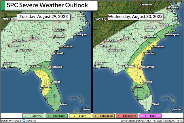
Widespread damaging winds, flooding rains, and a risk for tornadoes will extend well inland from the point of landfall, likely bringing hazardous conditions to a wide swath of the southeastern U.S. through the end of the week.

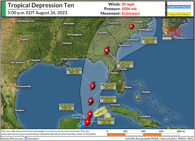
Tropical Storm Idalia is taking full advantage of the environment around the system this weekend as it rapidly gets its act together off the tip of the Yucatan Peninsula. The system, which has remained near-stationary for the past couple of days, used the opportunity to improve its structure and gather strength over the region's steamy waters.

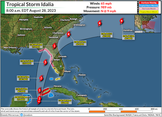
The storm had maximum winds of 65 mph by 8:00 a.m. on Monday, and it's likely going to grow into a hurricane during the day as it slowly makes its way north toward the western tip of Cuba.


Lower wind shear and ample warm waters will give the system free reign to strengthen as much as possible over the next couple of days as it heads toward the western Florida coast. The NHC calls for the storm to reach major hurricane status before landfall during the early morning hours on Wednesday.

At this point, the only potential impediment to its strengthening would be the storm's internal structure. If it struggles a bit, or undergoes an eyewall replacement cycle at some point, it will hamper (if not just briefly) the storm's strengthening trend.

Communities along the coast are at greatest risk for life-threatening conditions as Idalia strengthens and heads toward its inevitable landfall early Wednesday morning.

This is a high-stakes forecast, as small shifts in the storm's position or track could have huge implications for folks along the coast. It wouldn't take much of an eastward jog to bring the storm closer to the Tampa Bay area, which would push stronger winds, heavier rain, and a greater surge into the coast.

Source: NHC

The NHC expect a maximum potential storm surge of 7-11 feet along the Big Bend between the Aucilla River and Chassahowitzka, which could happen if the storm's landfall coincides with high tide.

Farther south, we could see a surge of 4-7 feet push into Tampa Bay, which could lead to extensive flooding in this heavily populated metro area. A surge of 2-4 feet is possible farther south in Charlotte Harbor, with tropical storm conditions bringing a 1-3 foot storm surge into the Keys.


The effects of a landfalling tropical cyclone don't stop at the coast. Idalia will maintain its strength for a good while after landfall, bringing hurricane conditions to much of northern Florida, and tropical storm conditions to a large swath of southern Georgia and coastal counties in the Carolinas.

Hurricane watches and tropical storm watches were in effect early Monday morning for much of inland Florida along Idalia's path, and these alerts will likely upgrade to warnings later this morning or afternoon.

Widespread tree damage and power outages are likely as the storm pushes inland, with some communities near the point of landfall and immediately inland potentially going without power for a week or longer.


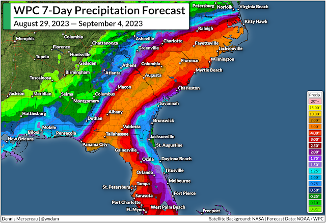
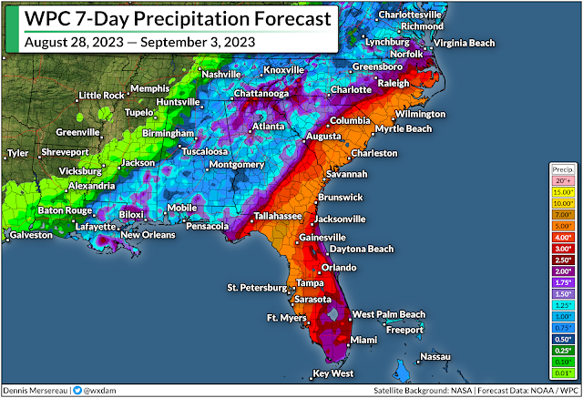
Flooding rains will pose a significant hazard to much of northern Florida and southern portions of Georgia and the Carolinas through the end of the week. A moderate risk for flash flooding will follow the storm's path inland, with Jacksonville, Savannah, Charleston, and Wilmington potentially seeing more than 5 inches of rain from Idalia by next weekend.

Again, the precise track of the storm will significantly affect where the heaviest rains fall. A jog east or west would push the greatest rainfall totals right along with it. There's also likely going to be a sharp cutoff in rain on the northern edge of the storm.

Flooding from heavy rain is the leading cause of death in any landfalling tropical cyclone. Most flood deaths occur in vehicles. It's a serious hazard that often gets overlooked in favor of the storm's raging winds.

Never try to drive across a flooded roadway. It's impossible to tell how deep the water is until you're already in it, and sometimes the road is washed out beneath the water. It only takes a small amount of water to lift a vehicle and carry it away, risking the lives of those in the vehicle and those who have to conduct rescue or recovery.


There's also a risk for tornadoes through the week as the storm makes landfall. Tornadoes are most likely along and to the right of the storm's path, which will place the greatest tornado risk across much of the Florida Peninsula and coastal sections of Georgia and the Carolinas.

Tropical tornadoes happen quickly, sometimes so fast that they leave little or no advanced warning before they form. Take a moment to check your phone and ensure that emergency alerts are activated for tornado warnings. Lots of folks disable them entirely after one too many ill-timed AMBER Alerts. These push alerts for tornado warnings are proven lifesavers. You don't want to miss an alert that could save you and your family.

The NHC will issue updates on the storm every three hours this week, with full forecasts issued every six hours at 5:00 and 11:00 a.m/p.m. Local National Weather Service offices will handle flash flood warnings and tornado warnings as the storm pushes inland.


Follow me on Facebook | Bluesky | Threads | Instagram | Twitter

Get in touch! Send me an email.

Please consider subscribing to my Patreon. Your support helps me write engaging, hype-free weather coverage—no fretting over ad revenue, no chasing viral clicks. Just the weather.


August 26, 2023

Heavy rain, high winds as budding hurricane likely to hit Florida by mid-week


A newly formed tropical depression entering the southern Gulf of Mexico could strengthen in a hurry as it heads toward Florida over the next couple of days.

The National Hurricane Center declared a well-organized disturbance near the Yucatan Peninsula as Tropical Depression Ten on Saturday afternoon.

Dynamics are favorable for this system to get its act together in a hurry. As it is, the storm is almost as impressive as Hurricane Franklin on visible satellite imagery—though initial looks are deceiving when it comes to a storm like this. 

Source: NOAA

Our tropical depression is still building its internal structure, and the NHC expects the system to encounter a favorable environment to organize and strengthen as it enters the eastern Gulf over the next few days.

Wind shear across the region will slacken over the next few days, and bath-like ocean temperatures in the Gulf of Mexico will easily fuel the storm's development if the storm's structure is able to live up to its full potential.


Forecasters aren't holding back on the tropical depression's potential through early next week. The storm, which will earn the name Idalia, could become a hurricane as it approaches western Florida on Monday and Tuesday.

Landfall is most likely somewhere along Florida's Big Bend, but the system is meandering off the Yucatan Peninsula right now, and small changes in the storm's location and path will have large ramifications on where it makes landfall. Anyone in the Florida Panhandle or the state's west coast should closely monitor this storm's progress.

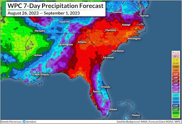
The storm's effects won't remain right along the coast, either. Drenching rains are possible well inland as the storm pushes into the southeastern states, bringing the potential for flash flooding as we head into next week. Downed trees, power outages, and isolated tornadoes are possible along the path of the storm once it makes landfall.


It's likely that the storm's intensity and predicted path will shift over the next couple of days. Remember that the storm forecast maps only apply to the center of the storm—hazardous winds and rain will extend hundreds of miles from the center of the storm.

Watches and warnings will likely be issued for the coast by Sunday or Monday. The NHC issues forecasts every six hours until alerts are issued, at which point forecasters will start issuing updates every three hours.


Follow me on Facebook | Bluesky | Threads | Instagram | Twitter

Get in touch! Send me an email.

Please consider subscribing to my Patreon. Your support helps me write engaging, hype-free weather coverage—no fretting over ad revenue, no chasing viral clicks. Just the weather.


September 28, 2022

'Catastrophic' Hurricane Ian Making Landfall In Southwestern Florida


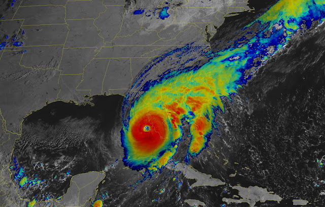
Hurricane Ian was one sneeze away from category five intensity as it careened into southwestern Florida on Wednesday.

The storm's rapid intensification over the steamy waters of the southern Gulf of Mexico saw Ian grow into a high-end category four hurricane with maximum winds of 155 mph. Forecasters at the National Hurricane Center (NHC) expect the storm to more or less maintain this strength as it pushes into the southwestern Florida coast through the day on Wednesday.


This is going to be a catastrophic storm for the region on a level that could easily surpass the devastation wrought by Hurricane Charley back in 2004. Former NHC Director Dr. Rick Knabb tweeted Wednesday morning that the entire extent of Charley's hurricane-force winds could comfortably fit within Ian's eye with room to spare.

Ian is a much larger and stronger storm than Charley was, and its destructive reach will spread over a much larger portion of Florida over the next couple of days.

Storm Surge

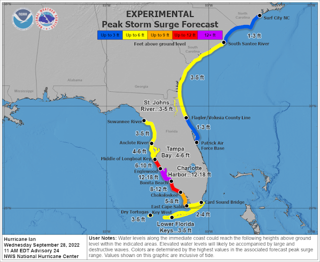
A devastating double-digit storm surge will push into southern Florida near where the hurricane makes landfall tonight. This is particularly terrifying for Charlotte Harbor and the mouth of the Caloosahatchee River, putting communities like Cape Coral, Fort Myers, and Punta Gorda at risk of a 12+ foot storm surge.

SOURCE: NHC

A storm surge on this magnitude will push very far inland, compounding the destruction. Thousands upon thousands of homes could be completely flooded out by this storm surge. Anyone who chose to remain at home (or didn't have the means to evacuate) will be at grave danger when the surge rushes in as Ian makes landfall on Wednesday night.

Flooding Rains

Hurricane Ian's ferocious winds are only part of this storm's danger. This will be remembered as a water storm as much as it'll be remembered for its destructive winds.

Florida will endure widespread flooding over the next couple of days as this slow-moving hurricane drops one to two feet of rain across the middle of the state. This much rain will inundate natural and man-made drainage systems, leading to flooding even in areas that don't typically flood during torrential rainfall.


The combination of wind damage, coastal storm surge, and inland flooding will stress local resources to their limit. Widespread water rescues are likely in the hardest-hit areas, and emergency officials may not be able to assist people whose homes are flooding during the storm's high winds.

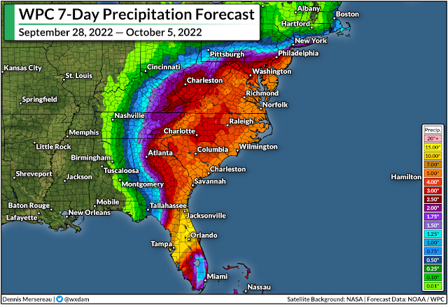
The risk for flooding isn't just limited to Florida. Widespread heavy rain will push into the interior southeast as Ian pushes inland through this weekend.

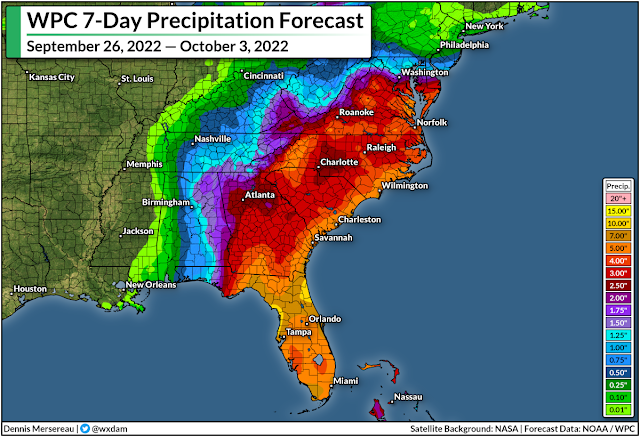
As I explained in Sunday's post, Ian is encountering a complex setup that will allow the storm to wring out drenching rains on the southeast. We'll see widespread rainfall totals of 3-6+ inches across the region, which will lead to a risk for flash flooding as far inland as the Appalachians in Virginia.

Winds/Tornadoes

Storm surge and freshwater flooding from prolific rainfall will cause significant and costly damage to the region, but we can't ignore the risk for wind damage. The eyewall is scraping some heavily populated areas. We're going to see widespread structural damage, tree blowdowns, and heavy damage to the power grid as this storm pushes ashore.


The wind threat doesn't stop at the coast. Hurricane warnings span the Florida Peninsula, with hurricane conditions expected all the way into the Orlando metro area as Ian pushes inland.

Forecasters expect Ian to reemerge in the Atlantic Ocean before making another landfall near the Georgia/South Carolina border.

This secondary landfall will bring tropical storm/near hurricane conditions to coastal sections of Georgia and South Carolina, where hurricane watches and tropical storm warnings are in effect. There's a chance Ian could regain hurricane strength before making landfall again on Friday.

Tornadoes are also a big concern for the Florida Peninsula and coastal Carolinas as Ian makes its way through the region over the next couple of days. 


You can follow me on Twitter or send me an email.

Please consider subscribing to my Patreon. Your support helps me write engaging, hype-free weather coverage—no fretting over ad revenue, no chasing viral clicks. Just the weather.


September 26, 2022

Hurricane Ian Could Send A Destructive Storm Surge Into Tampa Bay This Week


The only thing scarier than a strong hurricane threatening a major metro area is a strong and slow-moving hurricane threatening a major metro area.

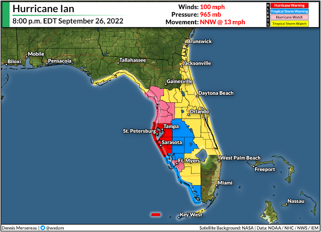
Hurricane warnings are in effect for the Tampa Bay area this evening as Hurricane Ian makes a beeline for the area.

The storm is going to grow very strong by the middle of the week as it approaches Florida's west coast. As if that's not bad enough, the storm is also going to slow down to a crawl as it parallels the peninsula, prolonging the high winds, heavy rain, and storm surge to 24+ hours for many areas.


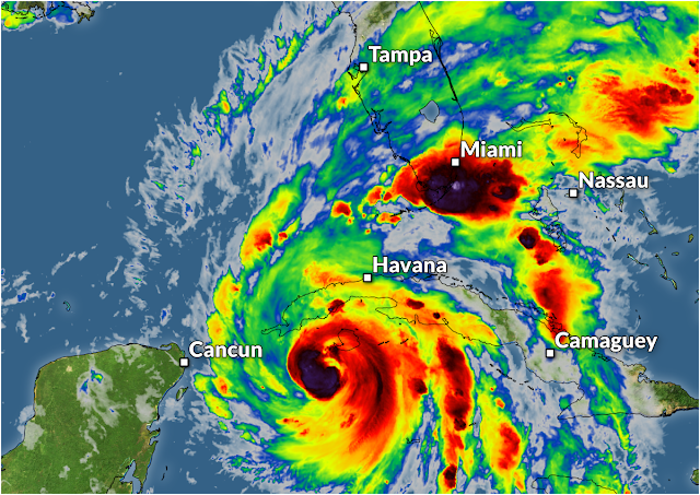
Hurricane Ian wound up in a hurry as it trekked through the western Caribbean Sea over the past couple of days. The storm is now a category two hurricane with maximum winds of 100 mph, and it's in a favorable environment for continued strengthening over the next couple of days.

The storm will make landfall on the western tip of Cuba overnight Monday before emerging in the southern Gulf of Mexico on Tuesday.

Forecasters with the National Hurricane Center (NHC) expect Ian to rapidly intensify as the storm hits the steamy waters of the southern Gulf, with the official forecast strengthening Ian into a frightening category four hurricane by Tuesday night.

Then the storm is going to hit the brakes.

SOURCE: Tropical Tidbits

A strong ridge of high pressure building over the Great Lakes will act like a barricade that will slow Hurricane Ian down to a crawl.

This thing is only going to be moving a couple of miles per hour as it approaches Florida's west coast. The forecast icons are practically on top of each other by the time the core of the storm is close to Tampa Bay.

Storm Surge

It may seem like a good thing that the storm isn't going to haul into Florida at full strength, but all things are relative with such a strong storm in such a vulnerable area.

SOURCE: National Hurricane Center

If the current forecast holds, this would expose the Tampa Bay area to the strongest part of the storm for an entire day or longer, funneling a deep and persistent storm surge into the bay and directly into the city of Tampa itself.

The NHC's storm surge forecast at 5:00 p.m. on Monday called for a 5-10 foot storm surge across the Tampa Bay area if the strongest winds in the storm coincide with high tide. This would be a destructive storm surge for coastal areas, and a double-digit surge would push well inland from the coast in spots.

Flooding Rains

Flooding from heavy and persistent rains is going to be one of the biggest impacts from this storm as it makes landfall and pushes inland through next weekend.


We could see rainfall totals of 6-12+ inches across the Florida peninsula during this storm. That much rain will easily overwhelm waterways and storm sewers, leading to flooding in vulnerable areas.

The heavy rain isn't going to stay limited to Florida, though. After landfall, Ian and its eventual remnants will slowly make their way into the southeast, where we're likely to see widespread heavy rain starting at the end of the week and lasting into the weekend.

A surge of tropical moisture riding on the back of a remnant storm is enough to prompt flooding rains under normal circumstances, but that same high-pressure system that will slow Ian to a crawl is also going to lead to a significant cold air damming (CAD) event across interior sections of the southeast.

SOURCE: Tropical Tidbits

Cold air damming occurs when northeasterly winds blow cool air up against the base of the Appalachian Mountains. The cold, dense air can't ride up and over the mountains, so it pools up across the piedmont region. It's infamously stubborn and approaching storms have a tough time scouring it away—warm air winds up riding up and over this dammed-up cold air, triggering widespread rainfall. 

A persistent conveyor belt of tropical moisture flowing up and over that cooler air at the surface will lead to several days of heavy rain, which could easily lead to flooding in vulnerable areas. There's also the potential for landslides in some of the Appalachians.

Winds

Hurricane-force winds are likely across the west-central Florida coast. Widespread and potentially long-lasting power outages are likely for the hardest-hit areas, especially if 100+ mph sustained winds manage to move ashore.


One of the most important preparations you can make for an approaching storm is getting ready for power outages. You never realize how underprepared you are until the lights go out.

Actual flashlights and battery refills are crucial so you don't waste your cell phone battery feeling your way around the bathroom.

Non-perishable, ready-to-eat foods like canned ravioli and fruit cups are a lifesaver when there's no power. It's tough to cook without electricity and the burger joints and coffee shops won't be open if they don't have power.

Tornadoes

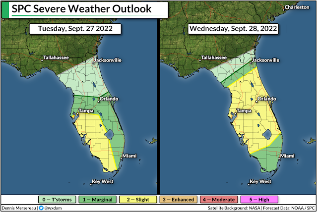
As with any landfalling tropical system, a risk for tornadoes will spread inland as the storm very slowly approaches landfall over the next couple of days.


Tornadoes are common in the right-front side of tropical cyclones because there's ample low-level wind shear to spark rotation in thunderstorms embedded in the storm's outer bands. Tropical tornadoes happen very quickly, sometimes only allowing forecasters to issue tornado warnings with only a minute or two of lead time.

Make sure you have a way to receive tornado warnings the moment they're issued, and have a plan to get to safety as quickly as possible if you hear that your location is under a tornado warning. Take a look at your cell phone now to ensure that wireless emergency alerts are turned on for tornado warnings. Lots of folks shut them all off after one ill-timed interruption for an AMBER Alert.

Tampa's Century-Long Lucky Streak Looks Finished

Tampa is one of the only major coastal cities in the south that's been relatively lucky when it comes to hurricanes. Plenty of storms have come close and even tracked over the area. Hurricane Zeta made landfall north of the bay area as a tropical storm in November 2020.

SOURCE: NOAA

The last time a major hurricane came close to Tampa Bay was an unnamed storm back in 1921. That storm caused widespread destruction across the region. Hurricanes tend to miss Tampa because prevailing winds tend to force storms to hit Florida from the east, and (with one recent exception) storms approaching from the south typically only clip the area on their way to the northern Gulf Coast.

Geography isn't protection. All indications are that Tampa's century-long lucky streak on missing strong hurricanes is going to fall this week. Please heed the advice and orders of local officials if you live in a vulnerable area, and please let your friends and family in the area know that this is a serious situation.


You can follow me on Twitter or send me an email.

Please consider subscribing to my Patreon. Your support helps me write engaging, hype-free weather coverage—no fretting over ad revenue, no chasing viral clicks. Just the weather.


June 2, 2022

Flooding Rains Likely For Florida As Tropical System Approaches


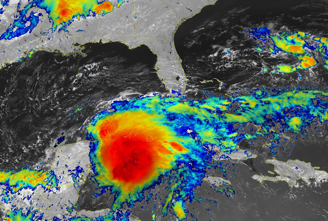
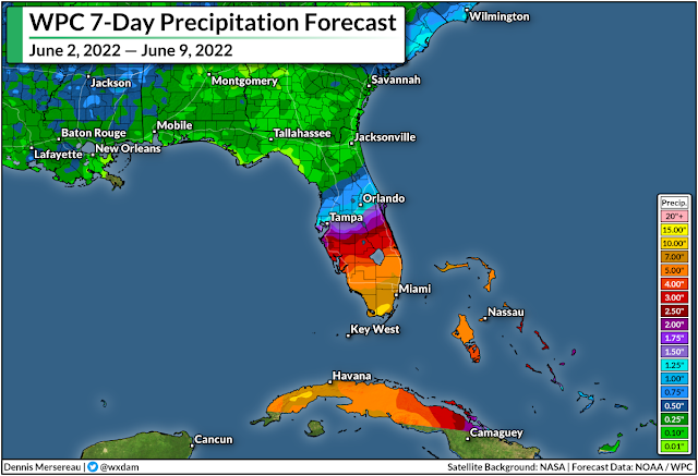
The first storm of the 2022 Atlantic hurricane season seems like it's a lock this afternoon as a robust tropical disturbance—the remnants of Hurricane Agatha from the Pacific—grows more organized in the western Caribbean Sea. Whether or not it fully develops, the system is mighty moisture-packed and it's going to bring a ton of rain to south Florida through the weekend.

The National Hurricane Center gives this disturbance an 80 percent chance of development in the next couple of days. The disturbance is developing an intense core of thunderstorms near the center of the system, and just by the way it looks on satellite, it probably doesn't have far to go before it grows into a tropical depression or a tropical storm.

This system, which would be named Alex if it becomes a tropical storm, is on track to pass over southern Florida on Friday and Saturday, with rain likely lingering into Sunday morning for portions of the Atlantic coast. 


Regardless of development, it's going to bring a ton of rain to the region. The Weather Prediction Center's latest outlook calls for 5-10+ inches of rain falling across south Florida through the weekend. This much rain falling this quickly could easily lead to flash flooding, especially in urban areas and spots with poor drainage.

Folks around here probably don't need the reminder, but the majority of deaths associated with tropical systems occurs as a result of drowning from flash flooding. Never cross a flooded roadway. It's impossible to tell how deep the water is until it's too late, and it only takes a few inches of moving water to lift up a vehicle and carry it downstream.

As with any landfalling tropical system or disturbance, developed or not, gusty winds could lead to downed trees and power lines. The low-level wind shear associated with systems like this will also likely lead to a risk for tornadoes, especially on the eastern side of the system. Make sure you've got a way to receive tornado warnings the moment they're issued. Check your phone and ensure that wireless emergency alerts are turned on.

[Satellite Image: NOAA]


You can follow me on Twitter or send me an email.

Please consider subscribing to my Patreon. Your support helps me write engaging, hype-free weather coverage—no fretting over ad revenue, no chasing viral clicks. Just the weather.