November 24, 2023

Cold air damming brought Greensboro a wild one-hour temperature tango


The weather is pretty darn cool this time of year.

Huge storms romping across the U.S. drag down frigid air from Canada while sucking warm air up from the Gulf of Mexico. Fast-shifting winds spiraling around these sprawling lows can create huge temperature differences over short distances.

Not every sharp temperature gradient is a pure case of Canadian air spilling into the waning remnants of summer. Weather conditions in some parts of the U.S. can depend as much on topography as it does meteorology, and few areas set a better example than central North Carolina.

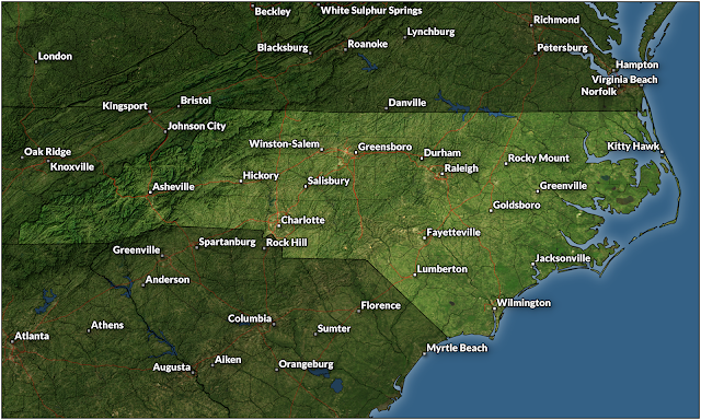
Greensboro, N.C., anchors the state's Piedmont region. Sitting nearly smack-dab in the center of North Carolina, conditions in the Piedmont are often influenced by the Appalachian Mountains that gently rise over the western third of our state.


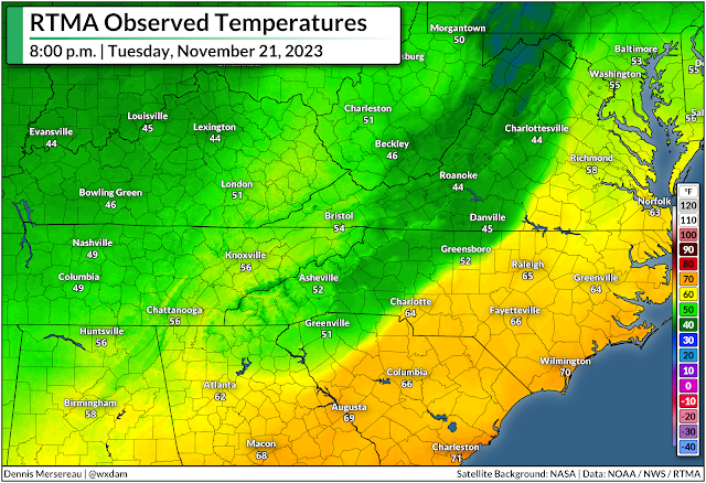
We feel this influence the most during the cool season through cold air damming. Chilly winds blowing in from the east or northeast smack against the side of the Appalachians like water held back by a dam. Cold air is dense, so the air can't rise up and over to Tennessee even as warm southerly winds try to scour it out of the region. 

Cold air damming is conspicuous on temperature maps, and it's a major headache for forecasters during winter storms. Frigid air at the surface and warmer air a few thousand feet above ground level is a recipe for sleet and freezing rain—something we see in abundance around here.


But for as tricky as cold air damming can be for precipitation forecasting, just predicting the hourly temperature can prove challenging during one of these setups.

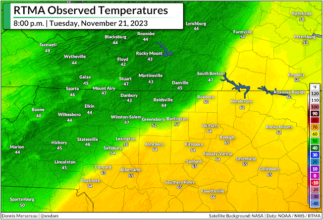
We didn't have to deal with any wintry weather on Tuesday, November 21, but a complex setup led to a wild temperature change in Greensboro over the course of just one hour.

A huge one-hour temperature bounce


Tuesday saw a robust low-pressure system moving into the Great Lakes while a center of high pressure lingered over New England. Northeasterly winds funneled down the coast locked-in a nasty bout of cold air damming in the Piedmont. 

Meanwhile, warm and humid southerly winds flowing into the region courtesy of that Great Lakes low tried their best to scour away the cold air at the surface. It didn't quite work, so that incoming air just rose up and over to fuel a day-long downpour.

The raw and rainy conditions on Tuesday brought the region our first substantial rain in months, which helped dent a growing drought and quench a bevy of wildfires burning throughout the region.


As the low over the Great Lakes dragged its cold front toward the Appalachians, a smaller center of low pressure developed on the eastern side of the Appalachians and tracked north into the N.C. Piedmont. 

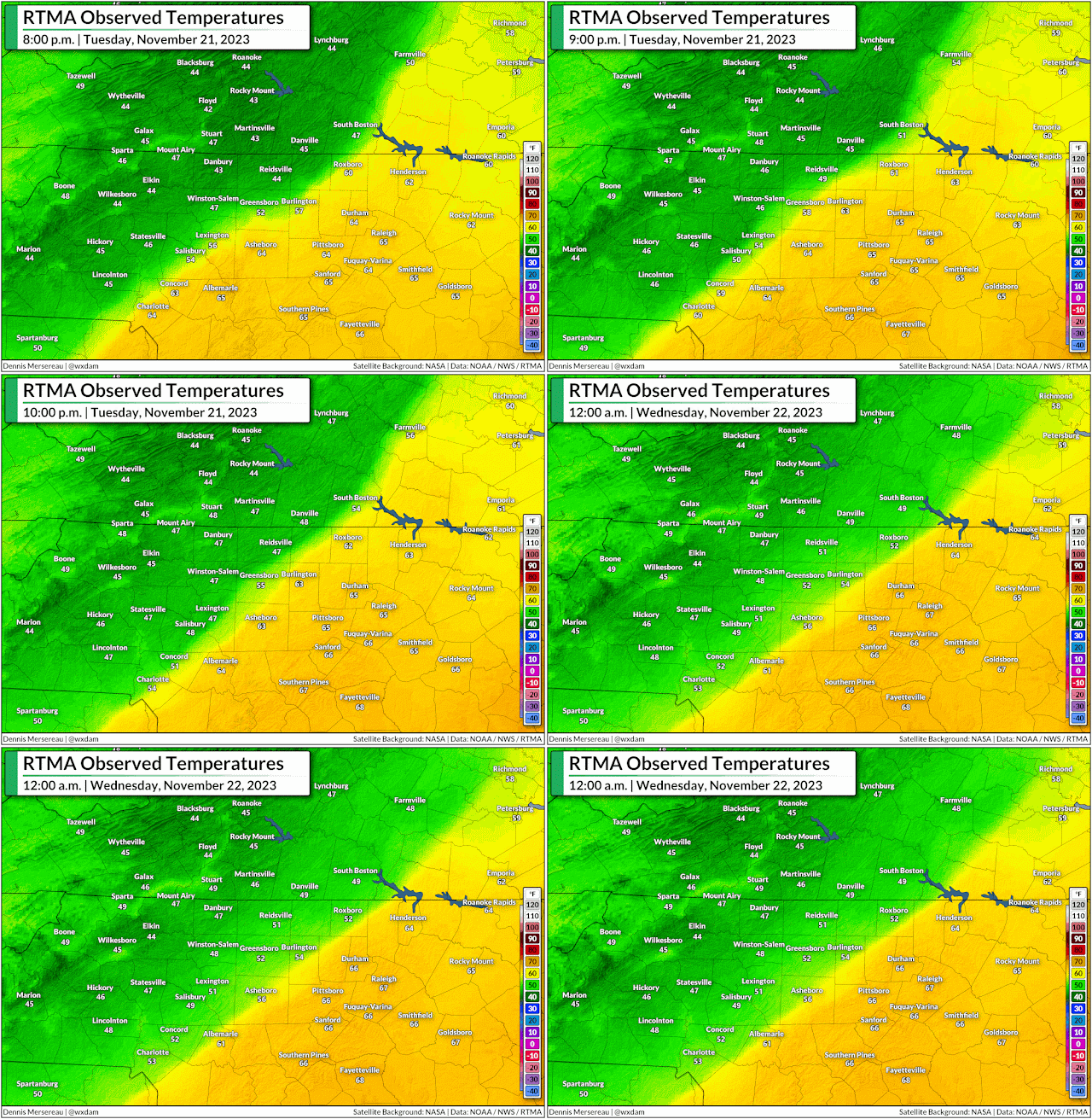
Enhanced southerly winds following that budding li'l area of low pressure lent a hand in trying to scour away the dam of cold air that had built up over the region on Tuesday. Persistence pays off, and communities right near the center of the low did see a significant temperature rise as it passed overhead.

Only briefly, though.

Very briefly.


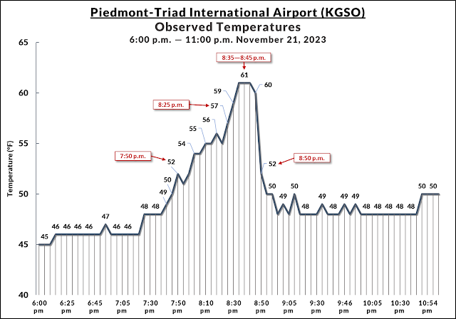
The temperature at Greensboro's Piedmont-Triad Int'l Airport slowly rose from the mid-40s to around 52°F by 7:50 p.m. on Tuesday.

Temperatures fluctuated very fast over the next hour. We saw temperatures warm by one or two degrees every couple of minutes until they peaked at 61°F at 8:35 p.m., remaining there for just ten minutes before the main cold front came in and caused temperatures to plummet even faster than they rose.

Behind the cold front, the temperature at PTI Airport tumbled from 61°F to 52°F in just ten minutes, soon sagging back to around 50°F for the remainder of the night.

It's not one of the more remarkable temperature swings we've ever seen—heck, there are towns on the Plains that can see a 40+ degree temperature drop in just an hour—but the complex circumstances that went into Greensboro's one-hour temperature tango is a fascinating peek at how our vast atmosphere can produce big changes over tiny areas.


Follow me on Facebook | Bluesky | Threads | Instagram | Twitter

Get in touch! Send me an email.

Please consider subscribing to my Patreon. Your support helps me write engaging, hype-free weather coverage—no fretting over ad revenue, no chasing viral clicks. Just the weather.


November 19, 2023

Classic fall storm could bring the southeast strong tornadoes, beneficial rains


A classic fall storm revving up across the central United States this week could bring severe thunderstorms to the southeast—along with beneficial rains for areas falling into a pretty serious drought over the past couple of months.

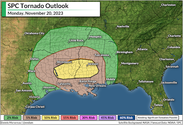
Some of the severe thunderstorms on Monday could grow quite strong across Louisiana and Mississippi, bringing a risk for a couple of strong, long-lived tornadoes.

Fall severe weather season ramps up

'Tis the season for severe weather in the south, and this looks to be our first real "second season" severe weather outbreak of the year. November and December see a noticeable uptick in severe weather across the southeast as powerful low-pressure systems develop over the Plains and roll north toward the Great Lakes.

Warm, humid air streaming north out of the Gulf of Mexico provides the instability, while the storm and its fronts provide the lift and wind shear needed to push the resulting thunderstorms beyond severe limits.

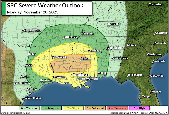
The Storm Prediction Center issued an enhanced risk for severe weather across northern Louisiana and much of southern and central Mississippi during the day Monday. Thunderstorms will develop during the afternoon and sweep across the region from west to east.


All modes of severe weather are possible, but the headline (as always) is the risk for tornadoes. Forecasters see enough instability and wind shear that a couple of those tornadoes could be strong or long-lived in and around the enhanced risk area.

Aside from the tornado risk, any of the thunderstorms that bubble over the region on Monday could produce strong wind gusts of 60+ mph, as well as a risk for large hail.

Make sure you have a way to get warnings

It's been a long while since we've had to contend with a risk for severe weather. Make sure emergency alerts are activated on your phone so you'll know the moment a tornado warning is issued for your location. Make a mental note of all the safe places at home, work, school, and various places you run errands in case dangerous weather strikes during the day.

Much of the severe weather threat on Monday and early Tuesday will unfold after sunset. Severe weather is especially dangerous after dark as people tune out and wind down for the evening. It's more important this time of year than ever to stay weather-aware, keeping up with storms nearby and having a way to receive warnings as soon as they're issued.

Remember—never rely on tornado sirens as your first line of defense. These sirens are outdoor warning systems not meant to be heard indoors, and they're prone to failure in bad weather.

A taste of beneficial rains on the way


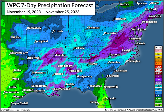
Even with the threat for severe weather, the widespread rain we'll see over the next couple of days is welcome news for just about everyone in the region.

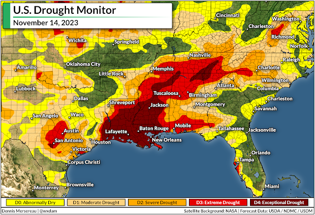
Much of the south has slipped into severe or extreme drought over the past couple of months as dry patterns prevailed and tropical systems largely avoided making landfall on the northern Gulf Coast.


Some areas have seen their annual rainfall totals fall more than a foot behind where they should be by the middle of November. It'll take a lot of rain to ameliorate the growing effects of this extended drought, but even an inch or two of rain is a welcome step in the right direction.

Another low-pressure system could develop in the western Gulf of Mexico late in the week around Thanksgiving, which could bring another quick hit of rain to areas that desperately need the water. Beyond that, we could be in for another dry pattern that'll likely last into the opening days of December.


Follow me on Facebook | Bluesky | Threads | Instagram | Twitter

Get in touch! Send me an email.

Please consider subscribing to my Patreon. Your support helps me write engaging, hype-free weather coverage—no fretting over ad revenue, no chasing viral clicks. Just the weather.


November 4, 2023

Rapidly intensifying hurricanes truly are the 'nightmare scenario'


Historic disasters have transitioned from a noteworthy abnormality to something that we've come to expect on a regular basis.

Unprecedented heat, devastating fires, destructive flash floods, and rapidly intensifying hurricanes are just the way things are. "Another billion-dollar flash flood? Add it to the two other we've seen this month."

This is going to be a more 'personal' post than I usually write for DAMWeather. I've covered a century's worth of unprecedented weather events in the past couple of years—almost all of it in a straight-news format.

I can't bring myself to do that for Hurricane Otis. I've spent almost two weeks trying (and failing) to write about the scale-topping hurricane that devastated Mexico's Acapulco region on October 24.

There are lots of worst-case scenarios when it comes to weather disasters. Hurricane Otis is one of the only storms in recent years that can legitimately claim the title of a worst-case scenario.

Hurricanes rapidly intensifying as they approach landfall is an alarmingly common disaster these days, and it's a horror that both people and governments still aren't prepared to confront.

Otis unexpected leapfrogged to a category five titan

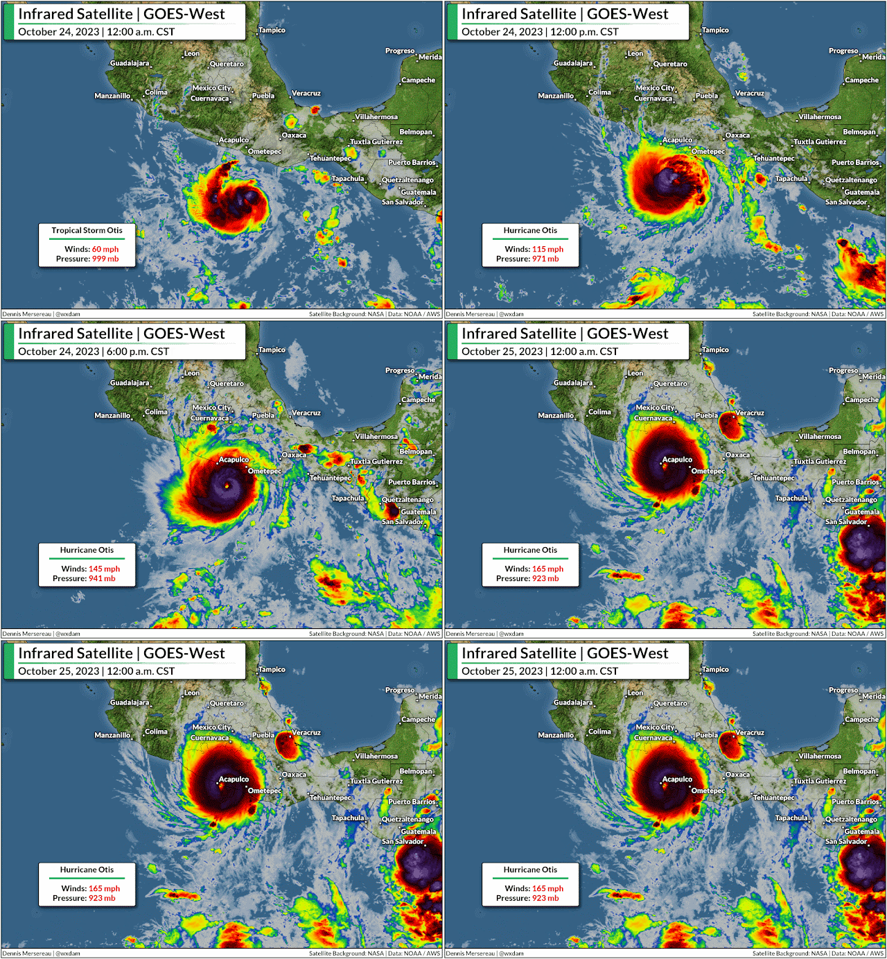
Otis rapidly intensified from a 50 mph tropical storm to a category five hurricane with 160 mph winds in just 24 hours, and it slammed almost head-on into Acapulco and its 1,000,000+ residents at maximum strength.


Hurricane Otis' explosive growth is one of the most intense rapid intensification events ever observed—beaten only by Hurricane Patricia in 2015, which peaked as the strongest hurricane ever reliably observed when its maximum winds reached 215 mph.

"The National Hurricane Center didn't mince words" is a phrase uttered too many times in the past five years as one record-busting hurricane after another swirled into yet another vulnerable swath of coastline somewhere in North America.


But the experts who dedicate their professional lives to tracking and understanding these atmospheric behemoths were flabbergasted by the hurricane's rapid growth. No forecaster or their computer models foresaw the storm growing into a major hurricane before landfall. The official NHC forecast called for Otis to maybe just barely crack hurricane strength as it crossed the coastline.

So to watch this hurricane run away in the atmospheric chain reaction from hell as it closed in on a heavily populated metro area was truly the 'nightmare scenario,' as an NHC forecaster said in the agency's update declaring the storm a scale-topping category five.


The nightmare played out.  We may never know exactly how strong the winds got in the heart of the city of more than one million people, but precise wind speeds seem irrelevant given the widespread destruction across the region.

Ten storms in ten years

Otis joined a long list of recent hurricanes that rapidly intensified in the run-up to landfall.

Harvey grew from a tropical depression to a category four storm as it approached Texas in September 2017.

Irma, once a scale-topping category five, rapidly reintensified into a category four when it hit the Florida Keys just two weeks later, keeping most of its power as it hit the state head-on soon after.

Source: NOAA

Two weeks after that, Maria rapidly intensified into a category four hurricane as it slammed into Puerto Rico.

Hurricane Michael exploded into a category five with 160 mph winds as it hit the Florida Panhandle in October 2018.

During the historic 2020 hurricane season, Laura quickly intensified into a 150 mph hurricane as it walloped southwestern Louisiana, barely losing strength at first as it drew energy from the swampy, surge-covered land. Exactly one year later, Hurricane Ida did the exact same thing as it hit southeastern Louisiana.

A year after that, Hurricane Ian intensified into a category five storm just before making landfall in southwestern Florida. The storm's destructive wind and surge killed more than 100 people, making it Florida's deadliest hurricane in a century.

This past August, Hurricane Idalia rapidly intensified in the eastern Gulf of Mexico and hit the Florida Panhandle as a category three storm. It was the strongest storm ever recorded at landfall in this part of the state.

That's just Atlantic hurricanes that revved up as they closed in on shore. There have been plenty of storms that rapidly intensified out to sea, and it doesn't even cover the storms—like Otis and unparalleled Hurricane Patricia from 2015—we've seen follow this trend in the eastern Pacific Ocean, or in the world's other tropical basins.

Consistently warm waters fuel rapid intensification trends

We've seen a tremendous stretch of unprecedented warmth across almost the entire Atlantic basin this year. It's the reason we've seen 20 tropical storms and hurricanes this year despite a strong El Niño over in the eastern Pacific.

The destructive wind shear generated by El Niño typically shreds apart any attempted tropical cyclones over the Atlantic. But sea surface temperatures in the Atlantic are so warm that any disturbance had the opportunity to develop—and they took full advantage of that unusual environment.


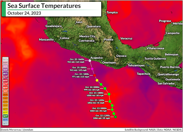
We can even see the influence of freakishly warm water when it comes to these eastern Pacific storms. Water temperatures off the western coast of Mexico were unusually warm when Hurricane Otis tracked over the region. Overlay the storm's track on top of a map of sea surface temperatures and it's easy to see a major reason that storm surpassed the most aggressive forecasts.

Time and time again, exceptionally warm sea surface temperatures are the driving force behind these rapid intensification events. It's not the whole story—a nearby jet stream improved Otis' outflow, for example, helping the hurricane strengthen in hyperdrive—but the freakish warmth in the Atlantic in recent years, and this year in particular, is a worrisome data point when it comes to future storms.

As the planet and its oceans continue to warm, we may have to contend with more of these sudden rapid intensification events in the future, including as storms snake toward landfall. 

That's downright terrifying when so many communities seem incapable of preparing for a storm they have a week to see coming. I recently wrote about our "strained attention economy" as a major reason so many well-advertised disasters seem to hit people by complete surprise. I am not confident that most people or community leaders are prepared for 'average' hurricanes, let alone these monstrous storms that ramp up within hours of landfall.

We've seen an entire lifetime's worth of tropical devastation from a handful of storms in the past couple of years. This year's amped-up storms won't be the last ones we see. At the very least, it's a strong argument to pay incredibly close attention to the weather during hurricane season, as the storm you went to sleep watching might not be the same one staring you down when you wake up.


Follow me on Facebook | Bluesky | Threads | Instagram | Twitter

Get in touch! Send me an email.

Please consider subscribing to my Patreon. Your support helps me write engaging, hype-free weather coverage—no fretting over ad revenue, no chasing viral clicks. Just the weather.