February 28, 2022

NOAA's Latest Weather Satellite Is Ready For Launch


If everything goes according to plan, NOAA will launch its newest weather satellite on Tuesday.

The agency plans to launch GOES-T into orbit from Cape Canaveral, Florida, during the late afternoon hours on March 1st. The launch window opens at 4:38 p.m. Eastern Time, according to NOAA's countdown clock.

GOES-T will be the 18th satellite in the Geostationary Operational Environmental Satellites (GOES) family of weather satellites that began in 1975. GOES-18, as it'll be named once it goes operational later this year, is the third satellite in the fifth generation of GOES spacecraft that began with the launch of GOES-16 in 2016. 

The fifth generation of GOES satellites relays breathtaking views of Earth with a resolution and timeliness that previous generations could only dream of providing. GOES-16, -17, and -18 have such fine resolution that you can see the barber's pole rotation of supercell updrafts churning over the Plains.

These satellites give us a full-disk view of the hemisphere every 15 minutes, an updated image of the continental United States every 5 minutes, and mesoscale images of small-scale areas every 30 to 60 seconds.

GOES-16, also known as GOES-East, has covered the Atlantic Ocean and eastern portions of North America and South America since early 2017.

GOES-17, launched on March 1, 2018, is known as GOES-West, covering the Pacific Ocean and western portion of the two continents. GOES-17 has also been a headache ever since it launched four years ago.

Scientists knew that GOES-17 suffered a major problem not long after launch.

We get our traditional satellite images from a device on the spacecraft known as the Advanced Baseline Imager (ABI). The ABI detects visible and infrared light radiation emitted from Earth and translates that data into the satellite images we know and love.

The different wavelengths correspond to different products we see—shorter wavelengths provide us the visible images astronauts would see looking out the window, while longer wavelengths are used for products like infrared and water vapor imagery.

An example of interference in infrared satellite imagery caused by excess heat given off by the ABI. | NOAA

The ABI gets quite hot during normal operation, especially at night when the sun is shining directly on the Earth-facing instrument itself. The instrument relies on a cooling system to prevent it from overheating. A clog in one of the cooling pipes hampered the system's ability to cool the ABI properly, causing it to overheat during times of the day and year when the instrument faced hot sunshine.

Not only is overheating bad for the instrument, but the radiation from the heat can actually interfere with and reduce the quality of the data it collects and the images we see. An example of the interference is shown above.

Scientists spent months devising a workaround for this cooling issue. They managed to bring the spacecraft up to near-normal capacity, but there are still certain times of the day and year where the sensor gets quite toasty and image quality is degraded.

On top of those issues, the satellite has faced a couple of glitches and hiccups over the last few years, each of which caused the ABI to unexpectedly shut down for a short period of time.

GOES-17 has had a rough go of it, to say the least. Luckily, GOES-18 is on the way to give it a much-needed rest. NOAA will position the device to take over as the new GOES-West satellite, moving GOES-17 to a parking orbit as a backup in case it needs to stand in for one of the two operational satellites.

We should start seeing our first experimental, non-operational images from GOES-18 in a couple of months.

[Satellite Image: NOAA]


You can follow me on Twitter or send me an email.

Please consider subscribing to my Patreon. Your support helps me write engaging, hype-free weather coverage—no fretting over ad revenue, no chasing viral clicks. Just the weather.
 

February 26, 2022

Winter Is Almost Over. Winter Is Far From Over.


Monday marks the end of climatological winter, an arbitrary turning point that signals the end of winter and beginning of spring. We're all starting to get spring fever, especially folks up north who've dealt with endless snow and cold over the past few months.

While we're starting to get tastes and teases of springtime weather, March is often a snowy and icy month across the country.

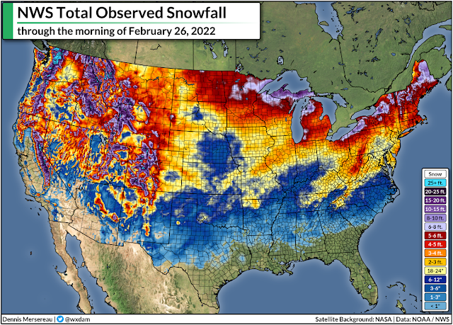
It's been a decently snowy year across much of the country. Washington, Greensboro, Buffalo, Chicago, and Kansas City have all recorded close to their average snowfall totals by the end of February. The arrival of an average winter is welcome news for snow weenies on the East Coast who've been pining for good storms for a couple of years now.

Here's a look at the country's seasonal snowfall through Saturday morning:


The bulk of the winter is behind us, sure, but the snow, ice, and cold temperatures aren't anywhere close to finished with us in March.

History is littered with plenty of memorable March winter storms, not the least of which is the 1993 "superstorm" that plastered the eastern U.S. from Alabama to Maine with more than a foot of snow. I flew home to central N.C. for spring break in March 2014 and we had several snow and ice storms during my short week back in the state.

How does history stack up, though?

Take a look at historical averages for the cities I mentioned above, covering the snow we've seen so far this season, the snow we typically see by March 1st, and how much snow we historically see after March 1st.
City Snow This Season Avg Snow By March 1st Avg Snow After March 1st
Washington 12.3" 11.8" 1.9"
New York City 17.5" 24.7" 5.1"
Greensboro 8.2" 6.3" 0.8"
Buffalo 82.9" 79.4" 16.0"
Chicago 28.6" 31.9" 6.5"
Kansas City 15.4" 16.3" 1.9"
Dallas 1.7" 1.3" 0.3"

On average, we still see a few more inches of snow across most major cities in the eastern and central part of the country...outside of the south, anyway. (Sorry Dallas.) Buffalo is the major winner here, of course, because their lake-effect snow ramps back up as the ice melts and the lake starts warming up again.

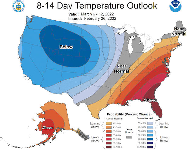
We're entering a pattern where it might be hard to get much snow through at least the first half of March. The Climate Prediction Center's latest 8-14 day outlook, which covers March 6-12, calls for decent odds of above-normal temperatures across a wide swath of the eastern states.

This kind of pattern will favour a more westerly track for storms, largely keeping the eastern states on the warmer side of any storms that move through. It only takes one storm slipping through an otherwise unfavorable pattern to bring us a memorable and unwelcome bout of March ice and snow.


You can follow me on Twitter or send me an email.

Please consider subscribing to my Patreon. Your support helps me write engaging, hype-free weather coverage—no fretting over ad revenue, no chasing viral clicks. Just the weather.
 

February 16, 2022

A Major System Will Close Out The Week With Gusty Winds, Snow, Ice, And Severe Storms


It's been a little while since we've had noteworthy active weather across the United States. A steep trough in the jet stream will spawn a potent low-pressure system over the Plains on Wednesday, setting the stage for a widespread risk for severe thunderstorms in the south while snow and ice coat communities from Kansas to Michigan.

The Setup

SOURCE: WPC

That's one messy map.

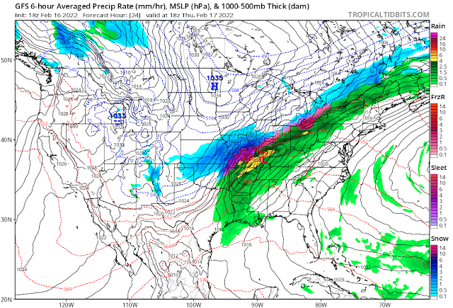
A robust low-pressure system will develop on the southern Plains early Thursday morning. The system will get its act together in a hurry, speeding across the Midwest toward the Great Lakes before reaching New England during the day on Friday.

We're going to see a little bit of everything with this storm, with heavy rain and severe thunderstorms to the south to a threat for snow and ice to the north.

The Wind Threat

The most widespread issue with this system will be strong, gusty winds.


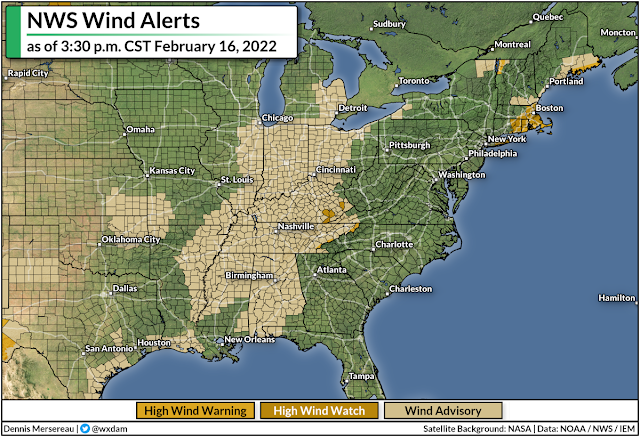
Wind advisories and high wind warnings are in effect for a large swath of the country from Alabama to Michigan, and it's likely that these alerts will spread east over the next couple of days.

The system will spread gusty winds across much of the eastern United States through Friday. Wind gusts of 35-45 mph will be common, with much higher gusts in some spots. The greatest potential for damaging winds exists near the eastern Great Lakes. Downed trees and power outages are likely in areas that catch the strongest gusts. 

The Severe Threat

Here's something we haven't had to deal with in a while, and it's directly related to those gusty winds.


Warm(ish), humid air on the southern side of the low-pressure system could fuel several days of severe thunderstorms across the south, beginning with the southern Plains on Wednesday.

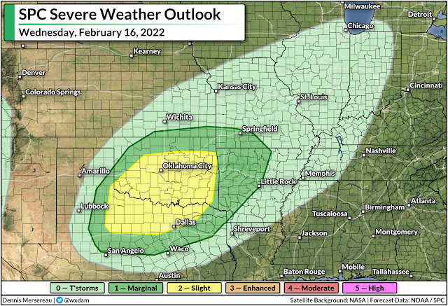
A slight risk for severe weather is up for parts of Texas, Oklahoma, and Arkansas on Wednesday. All modes of severe weather are possible here, including a threat for tornadoes across northern Texas and southern/eastern Oklahoma.


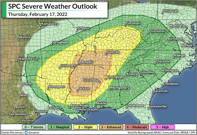
The storm threat will shift east on Thursday as the low pulls toward the Great Lakes. Severe thunderstorms could develop along and ahead of the cold front as it sweeps through the southeastern states. This is the first risk for severe weather we've seen in some areas, especially in the Carolinas, since last year.

The greatest threat from these storms will be damaging wind gusts. We'll see gusty winds with or without thunderstorms—it won't take much of a downdraft for a thunderstorm to shove even higher winds down to the surface, hence the widespread severe risk through Friday morning. 

A significant portion of Thursday's severe weather risk will unfold overnight Thursday into Friday. Nighttime severe weather is especially dangerous because it's easy to miss warnings after you've tuned out or you've gone to bed.

Take a moment today to check your cell phone and ensure that wireless emergency alerts are activated for tornado warnings. It's easy to switch all the alerts off after one ill-timed activation for an AMBER Alert, but those tornado warnings are proven lifesavers and can catch your attention when you're focused on anything but the weather.

It's also worth noting that the widespread heavy rain and thunderstorms could lead to a risk for flooding along and near the track of the low itself. Flood watches are in effect from southern Missouri to western New York, with several inches of rain expected for most areas. That typically wouldn't be a problem on its own, but the rain on top of snowmelt will lead to localized flooding issues, and ice jams could lead to swollen streams and rivers overflowing their banks.

The Snow/Ice Threat

Cold air to the north of the low will allow precipitation to fall as snow and ice, especially in the Midwest and around the Great Lakes. This won't be a widespread winter storm like the storm we saw a few weeks ago, but the quick thump of snow and ice could cause issues in some areas.


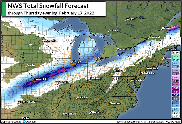
The National Weather Service's latest forecast calls for a narrow but potent swath of snow to fall from northern Oklahoma to northern Maine. The heaviest snow is likely across parts of Kansas, Missouri, and central Illinois, including the Kansas City metro area. We could see more than half a foot of snow across these areas. Several inches of snow could fall on the Chicago and Detroit metro areas, as well.

SOURCE: digital.weather.gov

As we often see around this time of year, warm air nudging in above the cold air at the surface will force some of the wintry precipitation to fall as freezing rain. We could see a light coating of ice along and north of the storm's track, with the heaviest totals possible in central Illinois and small parts of western New York and northern Maine.

This shouldn't be a debilitating ice storm by any means, but a glaze to one-tenth of an inch of ice accretion is enough to make travel dangerous and potentially bring down any weak tree limbs. The combination of the weight of the ice and gusty winds could lead to power outages.

[Model Graphic via Tropical Tidbits]


You can follow me on Twitter or send me an email.

Please consider subscribing to my Patreon. Your support helps me write engaging, hype-free weather coverage—no fretting over ad revenue, no chasing viral clicks. Just the weather.