June 28, 2022

Developing Atlantic Tropical Storm Set To Take An Unusual Track


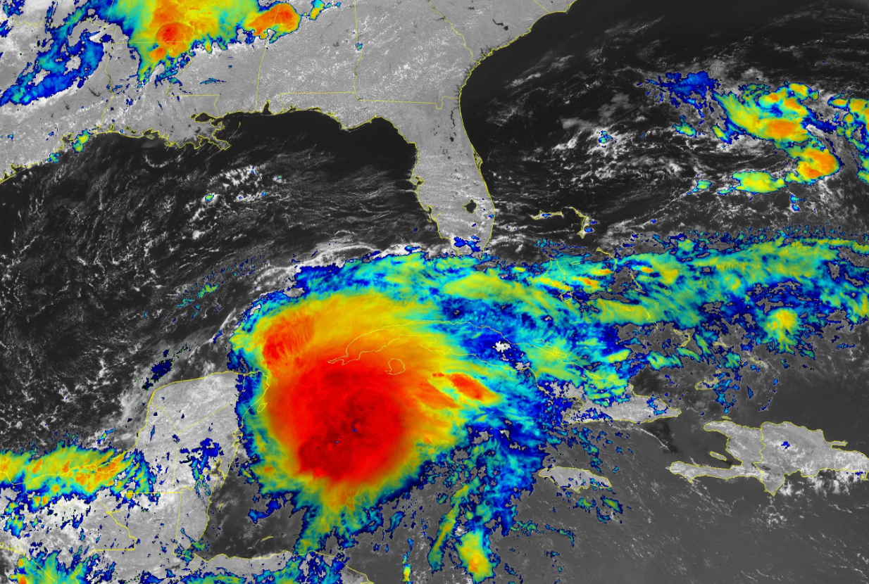
A tropical wave that's made its way across the eastern Atlantic Ocean for the past couple of days is on the verge of organizing into Tropical Storm Bonnie on Tuesday. The system will bring heavy rain and gusty winds to the southern Caribbean—which itself is unusual for the end of June, but it's an odd storm track altogether.

Southern Caribbean On Alert

The National Hurricane Center (NHC) calls the system "Potential Tropical Cyclone Two," a bureaucratic term that gives forecasters the ability to issue tropical storm watches and warnings before the system formally develops into a tropical depression or tropical storm.


Forecasters expect PTC Two to organize during the day on Tuesday, becoming Tropical Storm Bonnie as it approaches Trinidad and Tobago.

The storm will skim the southern periphery of the Caribbean Sea through the week, bringing foul weather to places like Aruba and the northern coasts of Colombia and Venezuela.

From there, the NHC's forecast calls for future-Bonnie to strengthen into a hurricane before making landfall in Nicaragua by the end of the week.

Any tropical cyclone is bad news for Central America—the region's rough terrain makes flash flooding and mudslides a life-threatening ordeal no matter how strong a storm is when it pushes ashore.

Strange Storm, Strange Track

The system's existence is a bit of an oddity for this early in the season. Early-season storms usually form closer to the United States, the result of decaying fronts or thunderstorm complexes that move into the western Atlantic basin.

We usually don't start seeing tropical waves push off Africa and move across the tropical Atlantic until the middle and latter half of the summer. This storm's origin isn't unheard of for the end of June, but it's on the extreme side of "huh, that's weird" for a storm this early in the season.


Not only are we dealing with a premature tropical wave, but it's going to follow an equally unusual track. A very strong ridge of high pressure over the eastern half of the Atlantic Ocean will push this system into Trinidad and Tobago, then allow it to skirt the northern shores of South America through the week.

Systems usually don't track this far south. 


Future-Bonnie's track is on the far southern edge of all recorded storms over the past 170 years of diligent recordkeeping—all as a result of that strong ridge.

Forecasters expect a busy hurricane season in the weeks and months ahead. This could be our eighth above-average season in a row, with more than a dozen named storms likely through this fall. It's more important than ever to make sure you're prepared for flooding, power outages, or worse, even if you live hundreds of miles inland.


You can follow me on Twitter or send me an email.

Please consider subscribing to my Patreon. Your support helps me write engaging, hype-free weather coverage—no fretting over ad revenue, no chasing viral clicks. Just the weather.


June 25, 2022

Two Tropical Disturbances To Watch In The Atlantic As June Rolls To A Close


The National Hurricane Center (NHC) is watching two disturbances in the Atlantic basin for potential tropical development as we head into the last week of June. One disturbance in the Gulf will bring heavy rain to coastal communities regardless of development, while the other is far out in the tropical Atlantic, with plenty of time to watch before it threatens land.

Gulf Disturbance


A cluster of thunderstorms hanging out over the northern Gulf Coast has a 20 percent (low) chance of developing into a tropical depression over the next couple of days.

This disturbance is one of those situations where it's bringing noteworthy impacts whether or not it actually forms into anything more. Heavy rain is falling over portions of southern Alabama, southern Mississippi, and southeastern Louisiana.

The latest rainfall forecast from the Weather Prediction Center calls for an additional 3-5+ inches of rain over the next few days. Heavy, tropical rainfall will lead to the threat for localized flooding in some areas.


It's worth watching regardless, because this is exactly where you'd expect to see a tropical system form in June.

Speaking of where it's normal to see storms...

Tropical Atlantic Disturbance

It's a bit unusual to talk about tropical development deep in the tropical Atlantic around the beginning of the season. Early-season storms tend to form close to land, often stemming off of decayed fronts or thunderstorm complexes. We don't start seeing true tropical waves rolling off the coast of Africa until we get closer to August.

Never say never, though. The NHC says there's a 60 percent (medium) chance of a tropical disturbance developing over the next couple of days as it steadily makes its way toward the Lesser Antilles. 

It's far enough from land that we don't have to worry about it just yet. There's plenty of time to watch its potential development and where it'll track.

Source: Tropical Tidbits

There's a strong ridge of high pressure over the central and eastern Atlantic Ocean that'll steer this system. The strength of the ridge will determine how far north it goes.

A stronger ridge will push it farther south—think Aruba and Nicaragua—while a weaker ridge would allow the system to pull farther north.

Slow Start To The Season...For Once

This year's seen a much slower start to hurricane season than we've seen in the past couple of years. 2022 is the first season since 2014 that didn't see its first named storm form before June 1st.

We did cut it close, though, when Tropical Storm Alex formed south of Bermuda after drenching Florida as a will-it-or-won't-it-develop type of deal.


Forecasters across the board expect this hurricane season to see above-average activity, though, as a result of La Niña and warmer-than-normal sea surface temperatures across the Atlantic.

It's a cliché, but remember that it really only takes one storm to make any hurricane season a bad hurricane season for you. Some of the worst damage has resulted from tremendous flooding produced by tropical storms, tropical depressions, and unnamed tropical disturbances.


You can follow me on Twitter or send me an email.

Please consider subscribing to my Patreon. Your support helps me write engaging, hype-free weather coverage—no fretting over ad revenue, no chasing viral clicks. Just the weather.


June 15, 2022

Strong Tornadoes, Damaging Winds Possible In The Upper Midwest Wednesday


Dangerous severe thunderstorms are possible Wednesday afternoon across portions of the Upper Midwest, with the bulk of the severe risk focused on Wisconsin. Storms in and around the risk areas could produce strong, long-lived tornadoes, damaging wind gusts in excess of 75 mph, and hail the size of golf balls or larger.

Wednesday's severe weather risk is a typical side effect of a heat wave like the one parked over the eastern half of the country right now. Severe storms thrive around the edges of the ridge, which often puts the Upper Midwest right in line for multiple rounds of rough storms for the duration of the heat wave.

A low-pressure system will develop over the northern Great Lakes during the day, setting the stage for severe thunderstorms to develop across the Upper Midwest.

The Storm Prediction Center issued a moderate risk, a 4 out of 5 on the agency's scale measuring the threat for severe weather, focused on much of Wisconsin, with an enhanced risk (3 out of 5) radiating outward to include northeastern Iowa and portions of Michigan's Upper Peninsula.


All modes of severe weather are possible on Wednesday afternoon. Strong, long-lived tornadoes are possible across most of Wisconsin. Storms could also produce damaging wind gusts of 75 mph or stronger, as well as hail the size of golf balls or larger.

This is one of those days where it pays to be proactive about watches and warnings. Check your phone and make sure emergency alerts are activated for tornado warnings. Scout out your home, office, or anywhere you plan to be today for safe places to take cover if you go under a tornado warning.

The threat for severe weather will shift toward the Northeast on Thursday, with a threat for tornadoes, damaging winds, and large hail focused on Pennsylvania and western New York.


You can follow me on Twitter or send me an email.

Please consider subscribing to my Patreon. Your support helps me write engaging, hype-free weather coverage—no fretting over ad revenue, no chasing viral clicks. Just the weather.


June 14, 2022

Heat Index Is Real, People Didn't Survive Before A/C, And Other Heat Wave FAQs, Answered


Q: How long is it going to stay hot?

A: As you can tell by the dramatic top image of a thermometer in the sunshine, a mainstay of lazy hot weather coverage, this heat wave isn't going anywhere.

Some of us might get a brief break this weekend, but the heat is going to build back even hotter next week. 100s are possible into the Mid-Atlantic.

Source: Tropical Tidbits

An upper-level low will swing across Ontario and Quebec later this week, sending a surge of (relatively) cooler air sinking down over the eastern United States. It'll be comfortable in the Northeast, but temperatures will only fall down into the upper 80s and low 90s in the southeastern states.

Meanwhile, a newer, stronger ridge will build in behind that upper-level low, allowing high temperatures in the 100s to spill into the northern Plains and Upper Midwest. That ridge will spread east through the weekend, reaching the eastern states by Sunday and Monday with round two of this prolonged heat event.


The heat index is going to make those brutal temperatures feel even hotter. The prolonged nature of this heat event is really dangerous for vulnerable communities. 

Q: The heat index is a ratings ploy to make it sound hotter than it really is!

A: The heat index is real. Your body cools off through evaporative cooling. Sweat evaporating from your skin helps to regular your body temperature when it's hot outside. Humidity interferes with this process.

When it's both hot and humid outside, your body has to struggle to maintain a healthy body temperature. If the dew point is 72°F—which is Florida-esque tropical mugginess—and the air temperature is 95°F, the heat index is 104°F, meaning that your body is feeling the same strain on that muggy 95°F day as it would if it were actually 104°F.

The higher the heat index, the more stress your body endures in the heat. It's a real thing despite what some hipster hot-take havers want to argue otherwise. Test it at your own peril.


Q: Just open the windows and you'll be fine.

A: Opening the windows and switching on fans can help with air circulation, but it all comes back to your body's struggle to cool off when it's both hot and humid.

Keeping the windows open and fans going doesn't actually lower the temperature. It feels cooler because it speeds up the evaporation of your sweat—a process that's disrupted by muggy temperatures.

The true danger is that a heat wave's effects compound with each day of excessive temperatures and humidity. Homes don't have a chance to cool down as one sweltering day bleeds into a stifling night. The stress grows on vulnerable populations with each day of a heat wave, regardless of whether you've got the windows open and a fan cranking.

Q: This is no big deal. People survived before air conditioning! Why are we so weak today?

A: It's called survivorship bias. Lots and lots of people died before air conditioning as a direct result of not having air conditioning.

It's sort of like the folks who scream "why do we need to coddle kids with all these safety features, I grew up just fine!" Sure, you may have turned out okay! But cemeteries are too full of too many little kids who, it turns out, couldn't get by without car seats or vaccines or wall-fastened dressers or unleaded paint on the windowsill. 

Even with air conditioning all over the place today, heat is still the leading weather-related cause of death in the United States. One bad heat wave can kill hundreds of people, a higher toll than years and years of tragic tornadoes combined. Last year's awful heat wave in the Pacific Northwest was Washington's deadliest weather disaster on record, and it killed nearly 600 people up in British Columbia.

Lots of people died before air conditioning. Lots of people still die without air conditioning. Consider yourself fortunate if you don't have to worry about that.


Q: Dry heat is better than a humid heat.

A: If the humidity makes your body work harder, wouldn't that mean a dry heat is better for you than a humid heat? Not necessarily.

An actual air temperature of 110°F with very little humidity in the air still makes your body work very hard to cool itself off. In fact, you can sweat too efficiently in a dry heat, potentially leading to faster dehydration and heat-related illnesses. 

Q: Why is every piece of hot weather advice so condescending?

A: Television meteorologists and online weather blatherers like me are very aware of how condescending it sounds to say "drink water and stay in the shade" to an audience that's almost entirely grown adults.

It's really, really easy to accidentally overdo it. I walk 5 miles every morning. I get cranky if I have to use the treadmill. But, even doing what I do, I have to consciously remember that the hot weather will knock me flat if I push it too hard. "I'm fine," right up until I'm half a mile from home with an empty water bottle and growing leg cramps.

Hearing safety advice over and over is annoying, but it works. It's worth if it one construction site calls it a day to keep its workers from getting sick, or if the sweet old lady down the street decides to do her power walk on the treadmill instead of pushing it in the hot sun.

Q: I'm not thirsty, so I don't need water.

A: Dehydration sneaks up on you. It's one of those things that's better to stave off than try to correct once it's taking a toll you.

Q: I'm healthy. I'm built for the heat. What's the big deal?

A: While the elderly, folks who suffer from medical issues, outdoor workers, and children are the most vulnerable to heat-related illnesses, it can happen to anyone.

Heat is the deadliest form of extreme weather and it's a silent killer to boot. To put it bluntly: someone dying alone in their sweltering apartment doesn't make as good of a headline as someone dying in a tornado, so it doesn't get much attention. 

Q: When will it cool off?

A: Probably in the fall.

Q: This article format is annoying. What gives?

A: It's a riff on this post from 2016. Meh. It's hard to be funny about a heat wave. It's strange—people lose their minds over a snowstorm like the world is ending, but they'll downplay the extreme dangers of heat even though it claims a toll many magnitudes higher than even the worst blizzard. Go figure.


You can follow me on Twitter or send me an email.

Please consider subscribing to my Patreon. Your support helps me write engaging, hype-free weather coverage—no fretting over ad revenue, no chasing viral clicks. Just the weather.


June 8, 2022

Prolonged June Heat Wave Set To Slide East Across The U.S. Next Week


A solid early-season heat wave is roasting towns from California to Texas this week, with a string of daytime temperatures easily climbing above 100°F for many areas. This pattern will slide east heading into next week, bringing a prolonged period of very hot weather to the rest of the southern states.

This week's heat wave is courtesy of a broad upper-level ridge parked over the southwestern corner of the country. Widespread excessive heat warnings and heat advisories are in effect ahead of temperatures that could soar above 110°F in some spots, including California's Central Valley and the typical heat-prone desert communities.


Phoenix is under an excessive heat warning until Sunday evening. The city can expect daytime highs in the low 110s with nighttime lows hovering in the mid-80s. It's a dry heat, we love to say, but raw air temperatures that hot—paired with day after day of nighttime temperatures offering little relief—can easily take a toll on even the healthiest individual. 

It's not as drawn-out of an ordeal over in California, but the heat will make for a couple of rough afternoons over the next few days. The most impactful heat will crank over the Central Valley on Friday afternoon, with a predicted high of 105°F in Sacramento, 104°F in Modesto, and an even 100°F up in Redding. 


The pattern leading to this heat ridge over the southwestern states will break by this weekend as a trough dips southeastward over the Pacific Northwest. That trough will kick the ridge east, setting up a prolonged heat event for the rest of the southern U.S. 

Heading into next week, widespread daytime highs in the mid- to upper-90s look likely from Texas to the Carolinas, with multiple days of 100s on tap for parts of Texas. We could even see temperatures approach the triple-digit mark as far east as the Carolinas. 


Humidity makes the heat even worse. It's not just a cliché—the extra moisture in the air makes it harder for sweat to evaporate from your skin, preventing you from cooling off efficiently. This can quickly lead to heat exhaustion or heat stroke if you're not careful.

Heat kills more people in the U.S. every year than any other type of extreme weather. Prolonged heat is especially deadly because of the stress exacted by days of extremely hot afternoons followed by sultry nights that offer no relief.

Source: CDC

The compounding effect of one hot day bleeding into the next exacts a terrible toll on vulnerable populations, such as low-income households without air conditions, the elderly, and those who are homeless or work long hours outdoors.

Most hot weather safety advice sounds condescending, but it's very easy for even a fit and perfectly healthy person to overdo it in hot weather and quickly grow ill because of overexertion. Drink more water than you think you need. Put off the chores and workouts until very early in the morning or late in the evening. The lawn will forgive you if you wait a week to mow it, and using a treadmill is better than passing out on a busy street.


You can follow me on Twitter or send me an email.

Please consider subscribing to my Patreon. Your support helps me write engaging, hype-free weather coverage—no fretting over ad revenue, no chasing viral clicks. Just the weather.


June 2, 2022

Flooding Rains Likely For Florida As Tropical System Approaches


The first storm of the 2022 Atlantic hurricane season seems like it's a lock this afternoon as a robust tropical disturbance—the remnants of Hurricane Agatha from the Pacific—grows more organized in the western Caribbean Sea. Whether or not it fully develops, the system is mighty moisture-packed and it's going to bring a ton of rain to south Florida through the weekend.

The National Hurricane Center gives this disturbance an 80 percent chance of development in the next couple of days. The disturbance is developing an intense core of thunderstorms near the center of the system, and just by the way it looks on satellite, it probably doesn't have far to go before it grows into a tropical depression or a tropical storm.

This system, which would be named Alex if it becomes a tropical storm, is on track to pass over southern Florida on Friday and Saturday, with rain likely lingering into Sunday morning for portions of the Atlantic coast. 


Regardless of development, it's going to bring a ton of rain to the region. The Weather Prediction Center's latest outlook calls for 5-10+ inches of rain falling across south Florida through the weekend. This much rain falling this quickly could easily lead to flash flooding, especially in urban areas and spots with poor drainage.

Folks around here probably don't need the reminder, but the majority of deaths associated with tropical systems occurs as a result of drowning from flash flooding. Never cross a flooded roadway. It's impossible to tell how deep the water is until it's too late, and it only takes a few inches of moving water to lift up a vehicle and carry it downstream.

As with any landfalling tropical system or disturbance, developed or not, gusty winds could lead to downed trees and power lines. The low-level wind shear associated with systems like this will also likely lead to a risk for tornadoes, especially on the eastern side of the system. Make sure you've got a way to receive tornado warnings the moment they're issued. Check your phone and ensure that wireless emergency alerts are turned on.

[Satellite Image: NOAA]


You can follow me on Twitter or send me an email.

Please consider subscribing to my Patreon. Your support helps me write engaging, hype-free weather coverage—no fretting over ad revenue, no chasing viral clicks. Just the weather.