Skip to content
DAMWeather DAMWeather DAMWeather

The weather can get scary. Reporting on it doesn't have to be.

DAMWeather DAMWeather DAMWeather

The weather can get scary. Reporting on it doesn't have to be.

  • About Me
  • All Bylines
    • Books, Bylines, and Press
    • The Skies Above (Book)
    • Extreme Weather (Book)
    • The Weather Network
    • The Vane
    • Forbes
    • Capital Weather Gang
    • Mental Floss
  • Maps
    • Hurricane Maps
    • Hurricane Names
    • Monthly Tornadoes
    • Tornado Tracks
    • F5/EF-5 Tornadoes
    • SPC High Risk Days
  • GIS Resources
  • Contact Me
    • Bluesky
    • Facebook
    • Instagram
  • wxdam.com

Tropical Storm Ian Could Hit Category Four Intensity In The Gulf This Week

By Dennis Mersereau
September 25, 2022 3 Min Read
It only takes one. 
The slow start to this year’s Atlantic hurricane season may not be what we remember about this season after all. We’re staring down the prospect of tracking our second major hurricane in a week, and this one could be a doozy for the Gulf states.
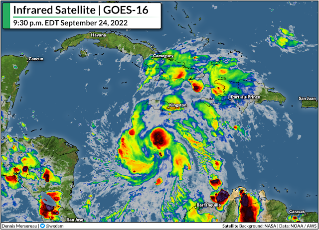
Tropical Storm Ian is a fledgling storm in the southern Caribbean Sea tonight. The system is still pretty weak, packing maximum winds of only 45 mph. However, the system is gradually getting better organized on satellite imagery—it certainly has “that look” to it—and it’s moving into an environment favorable for strengthening.
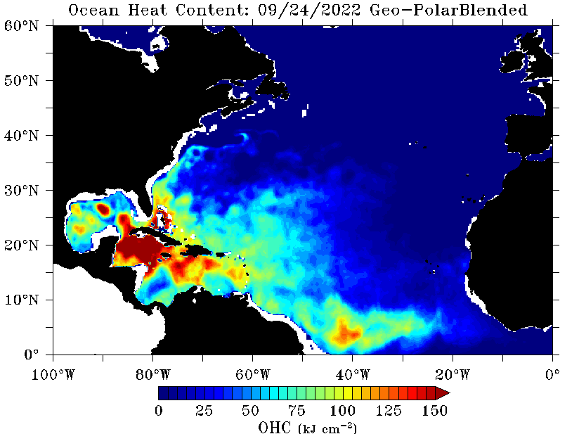
Ian is about to move over the warmest water in the entire Atlantic Ocean. Here’s a look at ocean heat content, which goes beyond sea surface temperatures to show the pool of warm water a developing tropical system can tap into:
SOURCE: NOAA

These waters have been relatively untouched by tropical systems this year, giving Ian first dibs on tapping into an entire summer’s worth of hot sunshine beating down on these tropical waters.
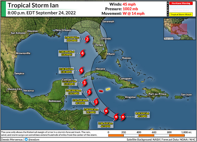
The latest forecast from the National Hurricane Center calls for Ian to undergo rapid intensification through Tuesday, growing into a category four storm as it passes the tip of Cuba.
There’s still plenty of uncertainty in the forecast. Rapid intensification is tough to forecast; it can catch us off guard as easily as a hiccup in the storm’s structure can prevent that sudden jump in intensity.
There’s also greater-than-normal uncertainty with Ian’s future track. Model guidance has slowly ticked the storm’s track farther and farther west with each update, which puts more of the northern Gulf Coast in line for the storm.

It’s still too early to tell where it’ll make landfall, but anyone from Gulfport to Fort Meyers needs to have a plan in place to deal with a strong hurricane in the Gulf by the middle of next week.

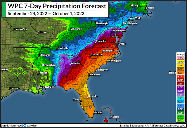
Regardless of its precise track, a hurricane entering the Gulf will have far-reaching consequences that extend far beyond the coast. The latest rainfall forecast from the Weather Prediction Center shows a widespread swath of very heavy rain falling over much of the southeastern states over the next week. We could also see a risk for tornadoes with the storm’s remnants when/if they push inland.


You can follow me on Twitter or send me an email.

Please consider subscribing to my Patreon. Your support helps me write engaging, hype-free weather coverage—no fretting over ad revenue, no chasing viral clicks. Just the weather.


Author

Dennis Mersereau

I have 15+ of experience providing hype-free weather information for folks across the United States and around the world. In addition to DAMWeather, I also contribute to The Weather Network as a digital writer and weather specialist.

Follow Me
Other Articles
Previous

Powerful Hurricane Fiona Sets Its Sights On Bermuda And Atlantic Canada

Next

Hurricane Ian Could Send A Destructive Storm Surge Into Tampa Bay This Week


Local ◈ UTC
Facebook | Bluesky
Instagram | Threads | Email
DAMWeather is now ad-free! Everyone benefits from engaging, hype-free weather coverage. Please consider supporting my efforts through Patreon:


Order The Skies Above today!

Bookshop.org || Barnes & Noble
Mountaineers Books || Amazon

My latest book, The Skies Above, is now available!

Did you know a puffy cloud can weigh millions of pounds? Or that every rainbow you see is unique to you?

Our atmosphere is full of spectacular sights that are always within your reach. Glistening layers of fog, gorgeous sunsets, and brilliant meteors flashing through the sky can light up even the calmest day.

The Skies Above, published by Mountaineers Books, is a celebration of what we overlook when we look up. I was thrilled to work with the editors and illustrators at Indelible Editions to share with you the quotidian beauty of our sky.

Order your copy now and learn about the wonders we take for granted every day.

I teamed up with the editors of Outdoor Life magazine to write The Extreme Weather Survival Manual, your guide to surviving and thriving in almost any weather condition. Whether you're an avid outdoorsperson or you enjoy watching the radar from the comfort of your home, you're sure to find helpful tips, advice, and new bits of knowledge in this fascinating book.

You can buy my book today through Amazon.
An error has occurred, which probably means the feed is down. Try again later.
  • 2026 (31)
  • 2025 (49)
  • 2024 (59)
  • 2023 (43)
  • 2022 (57)
  • 2021 (71)
  • 2020 (83)
  • 2019 (88)
  • 2018 (92)
  • 2017 (1)
  • 2016 (4)
  • 2015 (10)

Copyright 2026 — DAMWeather. All rights reserved. Blogsy WordPress Theme