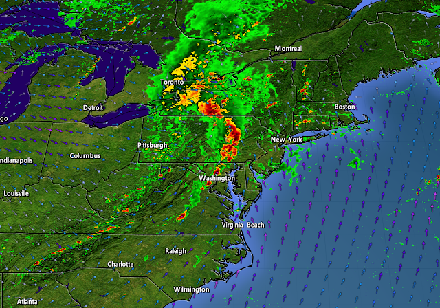
A widespread threat for severe thunderstorms will cover much of the East Coast on Monday as a cold front plows into the heat and humidity that's parked over the region in recent days. The storms could bring damaging wind gusts, a few tornadoes, and some instances of large hail. Make sure you've got a way to receive warnings the moment they're issued.
A trough swinging over the Great Lakes will allow a low-pressure system to develop across eastern Ontario and southern Quebec during the day on Monday. A cold front extending off this budding low will set the stage for a broken line of thunderstorms to sweep across the eastern states.
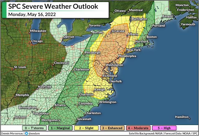
There's enough instability and wind shear for these thunderstorms to turn severe. The Storm Prediction Center issued a wide-ranging risk for severe weather on Monday, covering everyone from southern Georgia to interior Maine.
The greatest risk for severe weather—an enhanced risk, or a three out of five on the scale—will stretch from central Virginia to northern New York, including the metro areas of Washington, Baltimore, Philly, Syracuse, and Albany. The severe risk extends west to the mountains and east to include the entire I-95 corridor from Savannah up to Portland.
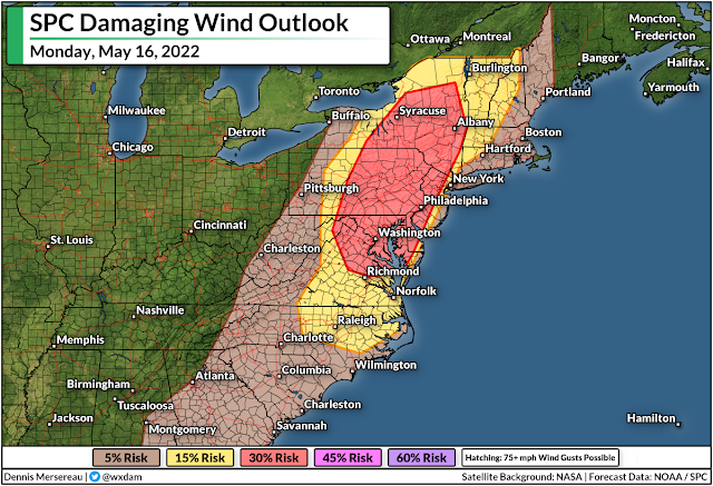
For most folks, the risk for damaging wind gusts of 60+ mph will be the predominant threat. However, folks in and around the enhanced (orange) and slight (yellow) risk zones could see a few spin-up tornadoes along the leading edge of any squall lines that move through.
Keep an eye out for alerts and prepare to act quickly if your location goes under a tornado warning. Take a second to check your phone and make sure emergency alerts are activated for tornado warnings.
It's worth pointing out for our friends up north that the threat for damaging winds and a tornado or two will extend into portions of eastern Ontario and southern Quebec, as well. This risk includes the National Capital Region, Montreal, and the Eastern Townships on Sunday afternoon and evening.
Conditions will calm down behind the front. Folks in the northeast will see a couple of days of cooler-than-normal temperatures before the heat starts to build back in toward the end of the week. Folks south of the Mason-Dixon line are looking forward to daytime highs in the 90s beginning Wednesday and lasting into the weekend.
[Top image created using WSV3]
You can follow me on Twitter or send me an email.
Please consider subscribing to my Patreon. Your support helps me write engaging, hype-free weather coverage—no fretting over ad revenue, no chasing viral clicks. Just the weather.
Please consider subscribing to my Patreon. Your support helps me write engaging, hype-free weather coverage—no fretting over ad revenue, no chasing viral clicks. Just the weather.


0 comments: