Skip to content
DAMWeather DAMWeather DAMWeather

The weather can get scary. Reporting on it doesn't have to be.

DAMWeather DAMWeather DAMWeather

The weather can get scary. Reporting on it doesn't have to be.

  • About Me
  • All Bylines
    • Books, Bylines, and Press
    • The Skies Above (Book)
    • Extreme Weather (Book)
    • The Weather Network
    • The Vane
    • Forbes
    • Capital Weather Gang
    • Mental Floss
  • Maps
    • Hurricane Maps
    • Hurricane Names
    • Monthly Tornadoes
    • Tornado Tracks
    • F5/EF-5 Tornadoes
    • SPC High Risk Days
  • GIS Resources
  • Contact Me
    • Bluesky
    • Facebook
    • Instagram
  • wxdam.com

Strong Winds Will Blow Across The Mid-Atlantic And Northeast On Friday

By Dennis Mersereau
April 30, 2021 3 Min Read

Who doesn’t love a good windstorm? (Most people, it turns out.) High winds are likely on Friday as a cold front pushes across the East Coast, prompting wind alerts from the southern Appalachians to northern New England. Some communities could see wind gusts of 50-60 MPH on Friday afternoon and evening, which could be enough to bring down trees and cause power outages.
A low-pressure system over New England will move east over the Atlantic Ocean overnight Thursday into Friday. A center of high pressure will build in over the Great Lakes behind the front, and the strong pressure gradient between the high over the lakes and the low over the ocean will lead to blustery conditions across the region.
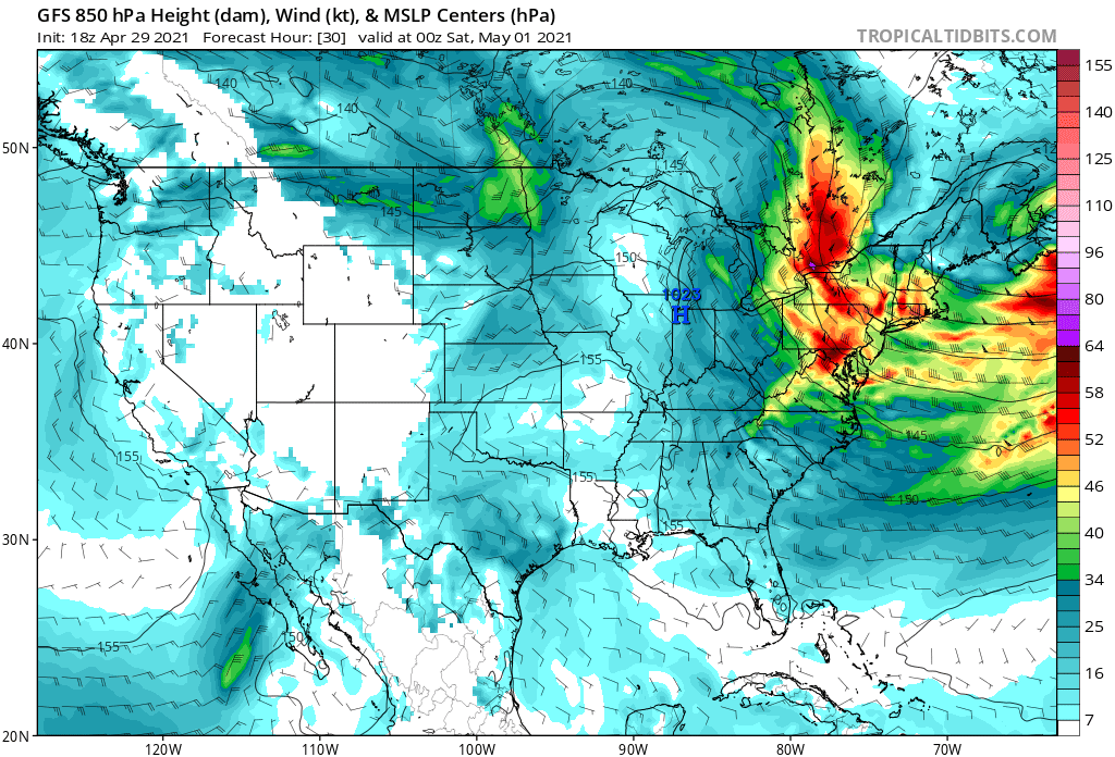
Modeled winds at the 850 mb level of the atmosphere on Friday evening. SOURCE: Tropical Tidbits

Winds in the lower levels of the atmosphere (around 5,000 feet or so) will crank up as they blow over the Northeast and Mid-Atlantic on Friday afternoon. Daytime heating causes the atmosphere to overturn as warm air rises and cool air descends to take its place. This churning motion—called “mixing”—can nudge some of those fast winds down to the surface, leading to the potential for strong wind gusts that could down trees and power lines.
A high wind warning is in place for parts of the Mid-Atlantic covering Delaware, much of New Jersey, central Maryland, and southeastern Pennsylvania, including Baltimore, Wilmington, and Philadelphia. These areas could see wind gusts as high as 60 MPH when the winds peak late on Friday. Wind advisories are in effect for the potential for 40-50 MPH wind gusts from New England on down the spine of the Appalachians.
Flights to, from, or over the Mid-Atlantic and Northeast could experience severe turbulence at times thanks to the strong winds, a point worth keeping in the back of your mind if you’re flying somewhere on Friday.

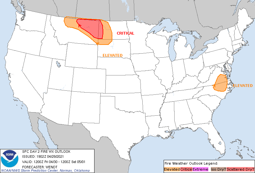
Dry air behind the front will lead to an increased fire risk for some areas. The Storm Prediction Center’s fire weather outlook issued on Thursday afternoon paints an elevated risk for fire weather conditions in parts of eastern North Carolina and Virginia, but local NWS offices issued fire weather watches for a much wider area that extends west to include upstate South Carolina and the Piedmont in North Carolina and Virginia. (The SPC fire weather outlook will update again in the very early morning hours on Friday.)
Gusty winds (and the associated wildfire risk) will wane overnight Friday into Saturday as the low pulls away from the Canadian Maritimes and the pressure gradient weakens. 


You can follow me on Twitter or send me an email.

Please consider subscribing to my Patreon. Your support helps me write engaging, hype-free weather coverage—no fretting over ad revenue, no chasing viral clicks. Just the weather.
 

Author

Dennis Mersereau

I have 15+ of experience providing hype-free weather information for folks across the United States and around the world. In addition to DAMWeather, I also contribute to The Weather Network as a digital writer and weather specialist.

Follow Me
Other Articles
Previous

Dry, Windy Conditions Increase Wildfire Risk In Southeast And Southwest On Wed. & Thur.

Next

A Wet And Stormy Pattern Will Drench The Plains Through Next Week


Local ◈ UTC
Facebook | Bluesky
Instagram | Threads | Email
DAMWeather is now ad-free! Everyone benefits from engaging, hype-free weather coverage. Please consider supporting my efforts through Patreon:


Order The Skies Above today!

Bookshop.org || Barnes & Noble
Mountaineers Books || Amazon

My latest book, The Skies Above, is now available!

Did you know a puffy cloud can weigh millions of pounds? Or that every rainbow you see is unique to you?

Our atmosphere is full of spectacular sights that are always within your reach. Glistening layers of fog, gorgeous sunsets, and brilliant meteors flashing through the sky can light up even the calmest day.

The Skies Above, published by Mountaineers Books, is a celebration of what we overlook when we look up. I was thrilled to work with the editors and illustrators at Indelible Editions to share with you the quotidian beauty of our sky.

Order your copy now and learn about the wonders we take for granted every day.

I teamed up with the editors of Outdoor Life magazine to write The Extreme Weather Survival Manual, your guide to surviving and thriving in almost any weather condition. Whether you're an avid outdoorsperson or you enjoy watching the radar from the comfort of your home, you're sure to find helpful tips, advice, and new bits of knowledge in this fascinating book.

You can buy my book today through Amazon.
An error has occurred, which probably means the feed is down. Try again later.
  • 2026 (31)
  • 2025 (49)
  • 2024 (59)
  • 2023 (43)
  • 2022 (57)
  • 2021 (71)
  • 2020 (83)
  • 2019 (88)
  • 2018 (92)
  • 2017 (1)
  • 2016 (4)
  • 2015 (10)

Copyright 2026 — DAMWeather. All rights reserved. Blogsy WordPress Theme