A Powerful Nor’easter Will Bring Hefty Snows To Parts Of The Mid-Atlantic And Northeast

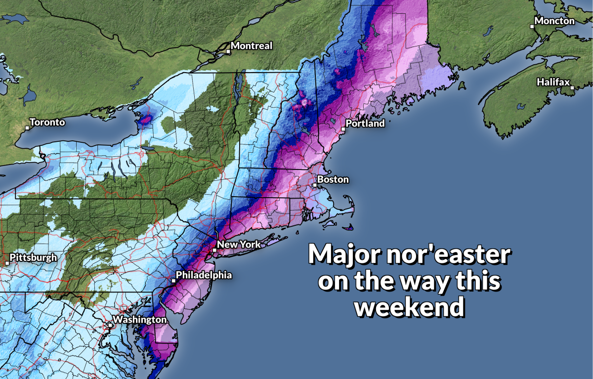
A powerful nor’easter will develop off the Mid-Atlantic coast on Friday night and race toward the Canadian Maritimes into this weekend. The track of the storm is extremely frustrating for meteorologists and residents alike—a tiny wobble to the west could bring major snowfall totals into big cities along I-95, while a small shift to the east could leave those cities with minor accumulations.
Winter storm watches and warnings are in effect from N.C.’s Outer Banks to the international border in Maine ahead of the impending system. The low-pressure system will develop off the North Carolina coast on Friday night, rapidly strengthening as it slides up the East Coast through the first half of Saturday.
Snow will begin over the Mid-Atlantic on Friday night as the system develops. A few inches of snow are possible into Virginia and North Carolina, with higher totals possible in the mountains.
For what it’s worth, it only takes an inch or two of snow to make a serious mess of things in these areas. You get a little bit of snow on the roads when temperatures are hovering around freezing. Hot traffic drives over the fresh snow which compacts and melts it, leaving it to freeze into a sheet of ice that all the traffic behind slips and slides on. It only takes a little bit to make a big headache.
Anyway, the bulk of the storm is going to affect the coast overnight Friday through Saturday afternoon, and it’s going to be such a close call for the big cities along Interstate 95.
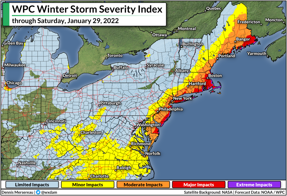
The Weather Prediction Center’s Winter Storm Severity Index (WSSI) does a good job telling the story of where the most impactful winter weather will take place. The red along the coast from the Delmarva Peninsula to the international border in Maine shows where communities will feel “major impacts” from steep snowfall totals and blowing snow from gusty winds.
If you look real close, you’ll see a smattering of purples—”extreme impacts”—along the coast from Cape May, New Jersey, up through Eastport, Maine. This is where high winds will likely lead to blizzard or near-blizzard conditions for a time during the storm Friday night through Saturday morning.
It’s looking increasingly likely that we’ll see disruptive snowfall totals from southern Delaware up through Maine, with more than a foot possible in parts of Massachusetts and Rhode Island. Millions of people live right along the fine line between conversational snow and “big deal” snow.
New York City could see between 2 inches and 20 inches of snow this weekend. https://t.co/jpVrW7J1dc
— NBC News (@NBCNews) January 26, 2022
Small shifts in the track of the system can lead to (seemingly) dramatic swings in forecast snowfall totals, as seen by the widely spread (and widely mocked) tweet from NBC News that said New York City could see between 2 and 20 inches of snow this weekend.
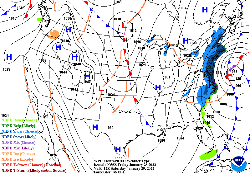 |
| The Weather Prediction Center’s forecast for 8:00 AM EST on Saturday, January 29, 2022. [NOAA/WPC] |
Nor’easters really are systems where track is everything. Tiny shifts to the east or west can have huge implications when it comes to snowfall totals. Think about what a band of heavy snow looks like on radar—not only is it narrow to begin with, but the sharp edges of the heavy snow can mean two neighboring towns can experience two completely different outcomes.
There’s a lot of frustration over the “well, we might get nothing, or we might get walloped,” but really, that’s just how it works with nor’easters. It sucks. It’s frustrating. But that’s how these storms go, especially when millions of people occupy a very slim swath of real estate near the coast. A shift of a dozen or two miles to the west could bury those towns, and a similar shift east could leave them without much to speak of.
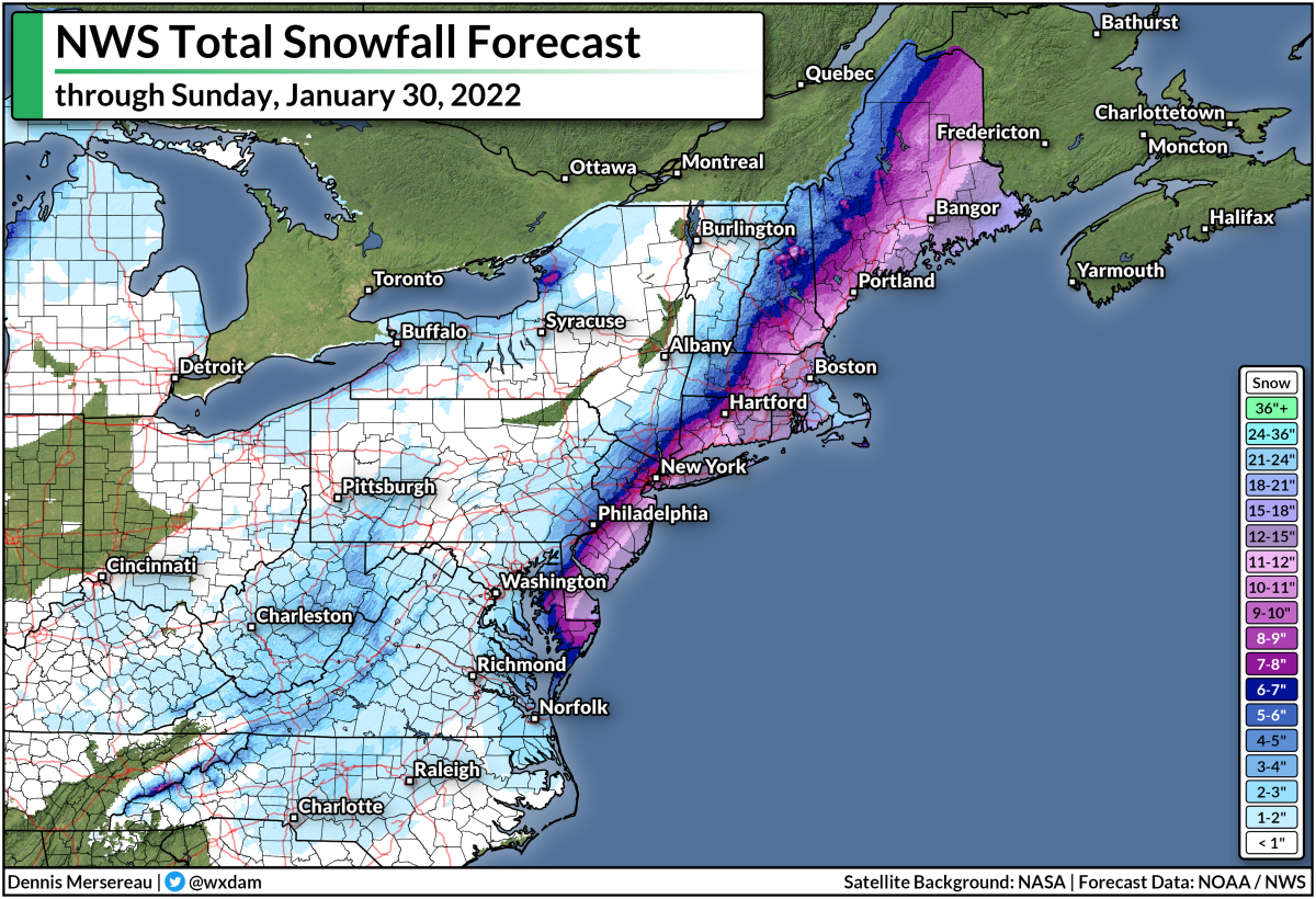
We’re likely going to see significant snowfall totals across the Mid-Atlantic and Northeast. Thursday evening’s forecast from local National Weather Service offices shows double-digit snowfall totals from the Delmarva to Maine, with parts of Rhode Island and eastern Massachusetts potentially scoring two feet of snow out of this system.
Just look at that western cutoff between a foot of snow and half that much. It wouldn’t take much of a westward nudge in the storm’s track to bring those hefty totals right into the megalopolis. That’s why meteorologists have collectively tugged at their collars over this forecast.
If you’re in an area expecting heavy snow and high winds, it’d be a good idea to find (or get) flashlights and a few battery refills just in case your power goes out on Friday night or Saturday. You don’t want to drain your cell phone battery on the flashlight feature. Also, remember to throw your phone on the charger before going to bed on Friday. It’s also a good idea to have some rechargeable battery packs for your cell phone so you don’t have to trudge out to the car for a recharge (or, worse, completely go without).
Also, stay mindful of trees or tree limbs that might loom near portions of your home. Most injuries during windstorms occur when trees fall into homes. If you have a large or unstable tree near your house, try to avoid those rooms during the high winds whenever possible. Better safe than sorry and all that.
You can follow me on Twitter or send me an email.
Please consider subscribing to my Patreon. Your support helps me write engaging, hype-free weather coverage—no fretting over ad revenue, no chasing viral clicks. Just the weather.