Fresh on the heels of a powerful nor'easter that brought blockbuster snows to New England is a new system that will affect an even wider swath of the United States. Snow, sleet, and freezing rain will develop across an enormous section of the country this week. This long-duration event could lead to continuous wintry precipitation for 24-36+ hours for some areas. Major travel and power disruptions are likely in the hardest-hit areas.
A Front Stalls And Causes A Huge Mess
First off, the term "winter storm" conjures up an image of a beautiful cinnamon bun-esque swirl gracefully plowing across the country. That's...not what this is going to look like. Here's the setup.
A large ridge of high pressure is building over the eastern United States at the same time that a trough digs down over the Canadian Prairies and northern Plains. We'll see plenty of active weather develop along the sharp contrast between the trough to the north and the ridge to the south.
 |
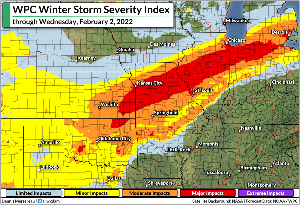
| This map shows the WPC's Winter Storm Severity Index through Wednesday, February 2, 2022. Higher categories indicate a higher potential for disruptive snow and ice. |
Down at the surface, we're looking at a center of low pressure scooting along the international border toward Ontario. The cold front stretching off this low will plow into the central U.S. by Tuesday night and then stall for the remainder of the week. Widespread lift along this front will lead to a slug of mixed precipitation extending from the Great Lakes south toward Texas.
We're going to see a huge zone under threat for snow, freezing rain, sleet, and regular ol' rain. The dividing lines between each precipitation type will be sharp and highly dependent on very subtle temperature differences a few thousand feet off the ground.
A Second Low Will Add Insult To Injury
At the same time the front stalls out, we'll see a low-pressure system starting to develop in Texas. This low will ride that frontal boundary up toward the Great Lakes on Wednesday into Thursday. This will bring a second round of mixed precipitation for roughly the same areas from Texas to the Northeast. We'll see the low track along the frontal boundary as it scoots toward New England through Saturday.
 |
| SOURCE: Tropical Tidbits |
The one-two punch of precipitation along the front and precipitation from the low means there's a good chance that many areas will see 24-36+ continuous hours of snow or ice. That's...a problem!
The animation above shows what the event looks like on Monday morning's run of the GFS model. This won't play out exactly as the model shows, of course, but it does a good job illustrating the long-duration potential for snow and freezing rain.
This Is Shaping Up To Be A High-Impact Event
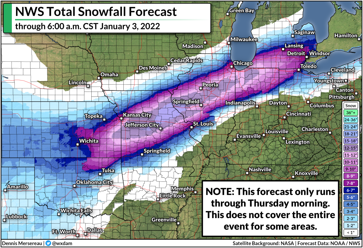
One issue with such a long-lasting event is that current snowfall and ice accretion forecasts don't cover the full extent of this event. Here's the National Weather Service's snowfall forecast through early Thursday morning:
We'll still see heavy snow falling at the end of this forecast period, with the likelihood of snow stretching toward the Northeast into Saturday. This doesn't cover all of what may fall this week.
It's a similar situation with maps showing the potential for ice accretion from freezing rain. Below is the National Weather Service's ice accretion forecast, running through Thursday morning.
 |
| SOURCE: National Weather Service |
Again, this doesn't show all of the freezing rain that may fall through the end of the week. These predicted totals will change as forecasters get a better idea of where the most freezing rain will fall.
Either way, we're on track to see an impactful ice storm for a very large area between the southern Plains and the Midwest, with the potential for disruptive ice even extending into parts of the Northeast. The geographic scope of the ice could stretch power crews to their limits, potentially leading to long-lived power outages for the hardest-hit communities.
On top of everything else, warm air and plenty of moisture on the southern side of that low will probably lead to a risk for flooding from heavy rain—and possibly a few severe thunderstorms—across the Deep South and the northern Gulf Coast toward the end of the week.
It's Never Too Early To Prepare
It's safe to say that this will be a high-impact winter weather event that will snarl travel by road, rail, and air, and potentially lead to widespread power outages. If you live anywhere that could see significant winter weather this week, here's what you should do right now:
➤ Invest in a few rechargeable battery packs if you don't have any. They're cheap, reliable, and can extend your cell phone's battery long enough to carry you until the lights come back.
➤ Gather up your flashlights and extra batteries, or get some from the store as soon as you can. You don't want to waste your cell phone's battery on light. A physical flashlight is an invaluable resource.
➤ Make sure you have ready-to-eat food like canned pasta and fruit cups so you don't have to struggle for food when the power is out. It's easy to forget how much food requires cooking until you can't cook.
➤ Prepare to alter any travel plans that could be affected by delays, cancellations, or road closures. You don't want to get stuck away from home when snow and ice are gumming everything up.
➤ If you can swing it, keep a few bucks on hand in case you need to buy something and can't use a debit or credit card.
➤ Refill any prescriptions that need refilling soon so you don't run out if you can't get to the pharmacy or the power is out.
➤ Take some time to scout out any trees or tree limbs that loom large near your house. Trim them if you have the means to do so safely. Trees falling into homes are a significant source of injuries during ice storms (and windstorms, too).
As always, keep up with the latest alerts from your local National Weather Service office. And don't overlook your local television meteorologists. Give them a follow on social media and pay attention to their posts. Systems like this are their bread and butter. They know their regions inside and out, and they all know the geographic quirks and local patterns that can really make their forecasts shine.
You can follow me on Twitter or send me an email.
Please consider subscribing to my Patreon. Your support helps me write engaging, hype-free weather coverage—no fretting over ad revenue, no chasing viral clicks. Just the weather.
Please consider subscribing to my Patreon. Your support helps me write engaging, hype-free weather coverage—no fretting over ad revenue, no chasing viral clicks. Just the weather.


0 comments: