The Anatomy of the April 15, 2018 Tornado in Greensboro, N.C.
One of the strongest and longest-track tornadoes to hit North Carolina’s Piedmont Triad in years touched down on the evening of Sunday, April 15, 2018. The EF-2 tornado developed just east of downtown Greensboro shortly after 5:00 PM on Sunday and tracked north along a 33-mile path before dissipating south of Danville, Virginia. The tornado damaged more than 1,000 buildings in Guilford County, North Carolina, alone, and resulted in one indirect fatality and at least 14 injuries. The thunderstorm responsible for the tornado left behind a path of wind and tornado damage from central South Carolina through central Virginia.
The Setup

April 15 was the third day of severe weather in an outbreak that began on the Plains on the evening of Friday, April 13. The storms that formed over the two previous days resulted in at least one fatality in Louisiana and injured a dozen more people as strong winds and tornadoes caused a swath of damage focused on Louisiana, Arkansas, and Mississippi.
The system responsible for the previous severe weather continued into the Ohio Valley on the morning of Sunday, April 15. Strong southerly winds near the surface raised temperatures and dew points into the 60s and 70s across the southeast during the day on Sunday, helping to provide enough instability to fuel severe thunderstorms. Winds from the southwest in the middle- and upper-levels of the atmosphere provided the wind shear necessary to organize the thunderstorms into squall lines and allowed some storms to rotate and produce tornadoes.

The Storm Prediction Center issued a risk for severe thunderstorms across the southeast and Mid-Atlantic during the day on Sunday. The threat stretched from the foothills of eastern Ohio south through the Florida Peninsula. An enhanced risk for severe weather existed across portions of the Carolinas and south-central Virginia due to the elevated risk for tornadoes.

The Thunderstorm

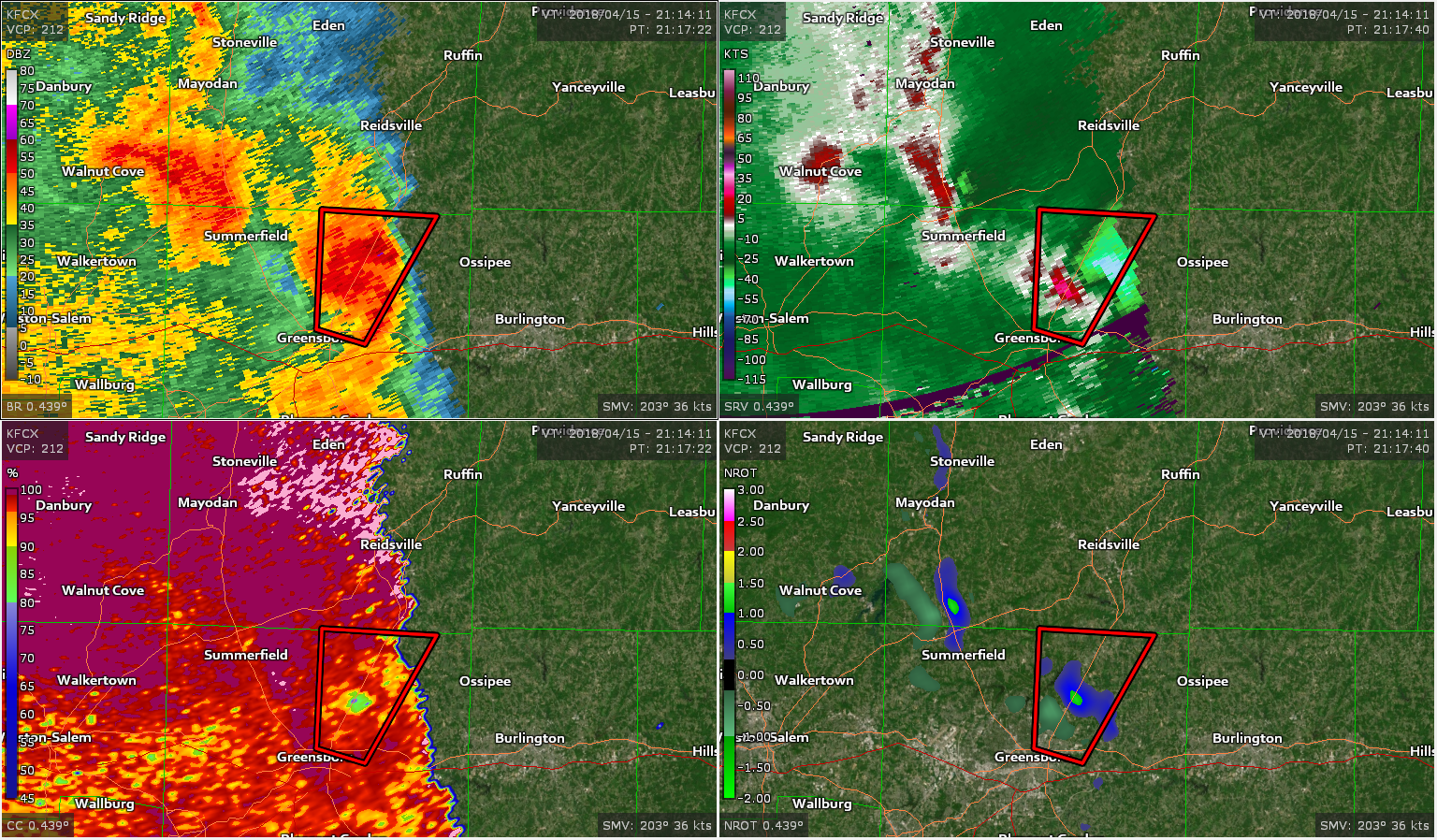
The Guilford-Rockingham Tornado


The tornado touched down just north of Interstate 40 on the eastern side of Greensboro, North Carolina, at 5:07 PM. The tornado damaged multiple homes and Peeler Elementary School as it strengthened and moved north.
Hampton Elementary School took a direct hit from the tornado as it reached its peak intensity with 135 MPH winds at 5:10 PM, producing damage that was right on the border between EF-2 and EF-3 intensity on the Enhanced Fujita Scale. Meteorologists from the National Weather Service in Raleigh estimated the tornado’s peak intensity by the complete destruction of mobile classrooms at the elementary school.
Television station WFMY had to delay their live coverage of the tornado as their crew and staff sought shelter in a hallway while the tornado tore up neighborhoods not far from the station.
A tree fell on a car near the intersection of E. Cone Blvd. and Cesar St. in Greensboro. The driver passed away from his injuries. This was the only fatality caused by the storm, but it was far enough away from the tornado’s track that it appears strong thunderstorm winds took down the tree rather than the tornado itself.
The tornado continued damaging hundreds of homes as it moved north away from the school and out of Greensboro city limits into unincorporated Guilford County. The path of damage shows the tornado slowly changed course toward the northeast until the storm eventually paralleled U.S. Highway 29.
Guilford County Emergency Services estimates that more than 1,000 structures were damaged by the storm in Guilford County alone; 199 homes and businesses suffered major damage (162) or were completely destroyed (37).
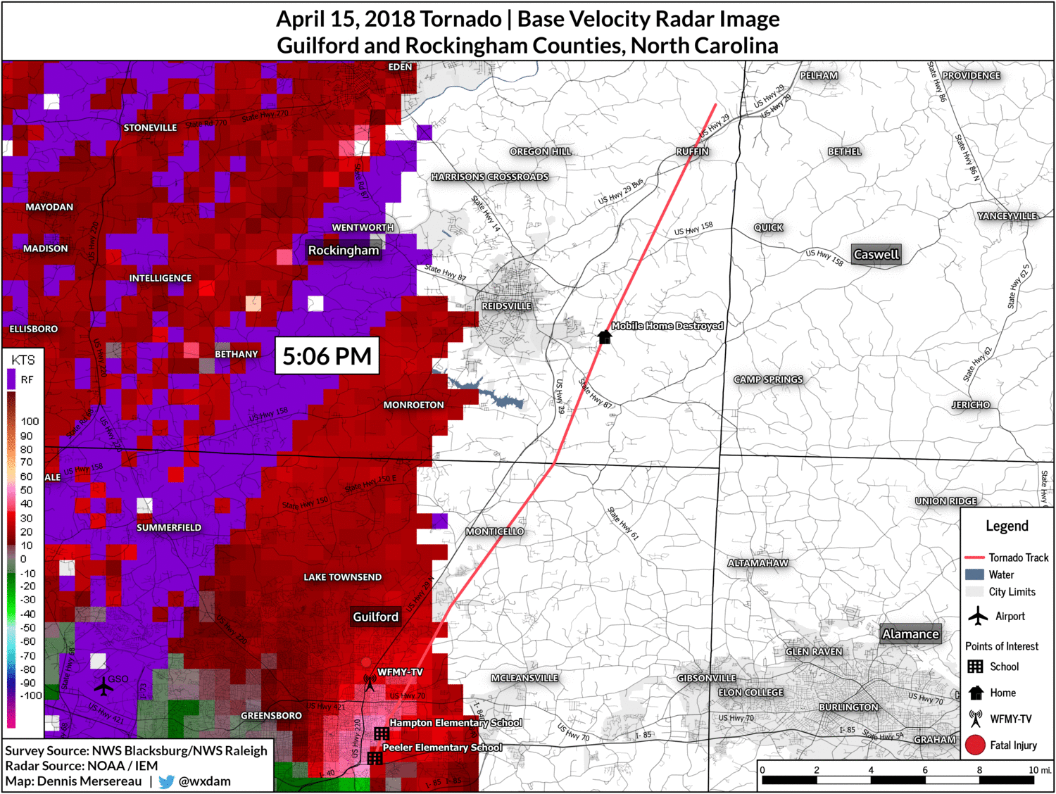
Raleigh’s storm survey estimates that the tornado was an EF-0 with 80 MPH winds when it crossed into Rockingham County at 5:24 PM.

A significant amount of debris fell on southern Reidsville (where I live) as the tornado weakened and passed a few miles to the southeast of the city around 5:30 PM.
I witnessed several pieces of plywood and insulation fall from the sky before the winds picked up. I took a walk around my apartment complex after the storm and found a significant amount of insulation, large shards of plywood from buildings, many shingles, several large pieces of metal, a computer cable, a window screen, a six-foot strip of vinyl siding, and some other structural debris that fell during the storm. Several large pieces of sheet metal, presumably used as roofing material, also managed to make it up to Reidsville.
It’s common to hear of light objects like papers or photographs traveling many dozens of miles after a strong tornado, but the amount of debris that fell on Reidsville surprised me. Most of the debris was able to make it the 15+ miles from Greensboro to Reidsville because it was light enough to easily float in the wind or its surface area was great enough that the debris caught the wind like a sail. Some of the pieces of metal were easily 10 or 20 pounds—so heavy that I couldn’t throw them 10 feet let alone the 15 miles they were carried by the tornado—which is a testament to the power of both the tornado and its parent thunderstorm.
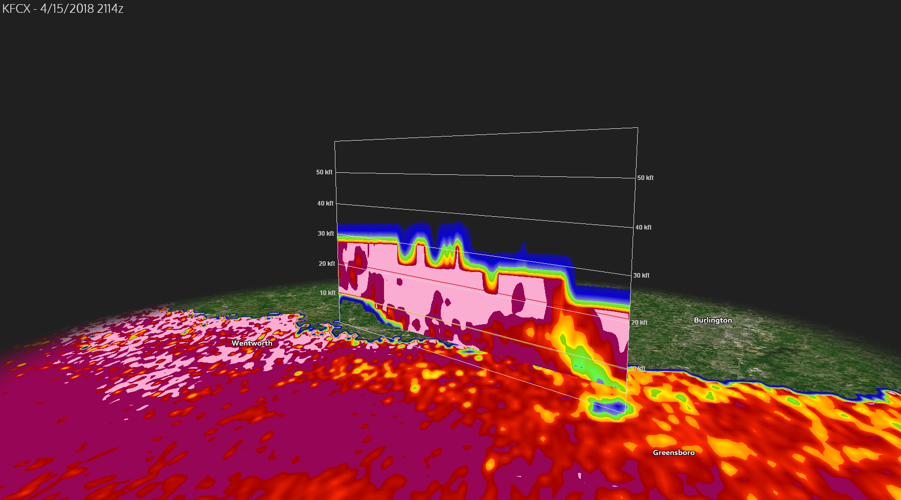
It appears that the reason so much debris from Greensboro fell on Reidsville is that the storm weakened as it approached Rockingham County and the tornado itself changed direction even as the winds in the lower- to mid-levels of the atmosphere stayed the same. Doppler radar data shows debris lofted nearly 20,000 feet into the atmosphere as it moved through eastern Greensboro. The radar data shows the debris moving with the thunderstorm over the next 20 minutes as it slowly descends before the bulk of the debris falls out over southern Reidsville.
A couple of minutes later, the tornado restrengthened and reached EF-2 intensity with winds of 125 MPH as it destroyed a mobile home and damaged multiple homes along Grooms Road in eastern Reidsville. The mobile home tumbled several hundred feet across the road, striking a moving vehicle and critically injuring the driver and his son.
The tornado continued through Ruffin, North Carolina, before finally dissipating at 5:46 PM.
Two more tornadoes would occur along the path of this storm for a total of seven during the thunderstorm’s lifespan. The storm produced another tornado in the City of Danville shortly after the storm crossed into Virginia, leaving behind EF-1 damage along its 12-mile path. A little more than an hour later, the same storm produced an EF-3 tornado near Lynchburg, Virginia, destroying many homes and injuring at least 12 people along a 20-mile track.
The initial tornado warning for this storm was not issued by NWS Raleigh until 5:09 PM, two minutes after the tornado touched down. The warning was amended at 5:16 PM to indicate that a tornado was confirmed due to the presence of debris on radar. NWS Blacksburg issued a tornado warning for Rockingham County at 5:18 PM, six minutes before the tornado crossed the county line and 15 minutes before it injured people in Reidsville.
You can read the storm surveys conducted in Guilford County and Rockingham County, as well as the text of the tornado warnings for both Guilford and Rockingham Counties.
Triad Tornadoes

Significant tornadoes aren’t common in the Piedmont Triad, which encompasses Greensboro, Winston-Salem, Burlington, and surrounding communities. Tornadoes that do form in the Triad are typically weak and short-lived. Before last week, only five tornadoes in the past 20 years to form in this area were rated F2/EF-2 or higher on the Fujita Scale.
Tornadoes are most common in the eastern part of North Carolina where the ingredients for outbreaks are more often present due to the flatter terrain and more favorable environment closer to the ocean. The presence of stable air and influence of the mountains typically reduces (but by no means eliminates) the tornado threat in central and western North Carolina.


