Spring May Finally Start Acting Like Spring in May
Most of us have had it relatively easy when it’s come to temperatures over the past few months. It’s nice to be able to keep the windows open this late into April. It’s nice to have a relative reprieve from severe thunderstorms—”relative” does a good deal of work in that sentence, of course. But the pattern keeping much of the United States east of the Rockies cooler than usual is having a negative impact in some places, and it will soon start to break and usher in a more seasonable setup over the next week or so.
East-West Divide

The cool weather of late is so deceptive that it’s even easy to forget that you have to wear sunscreen if you’re going to spend any length of time outside these days…not that I would know anything about that. You can see the stark difference in temperatures between west and east if you look at daily average temperatures so far this month.
The daily average temperature—the day’s high and low averaged together—gives you a good idea of how abnormally warm or cool a day was on the whole. Since highs and lows alone can be deceiving, averaging daily average temperatures together for a period of time is the best way to determine whether it’s been warmer or cooler than average during that period. The above chart shows the average of the daily temperatures between April 1 and April 24 for 17 cities across the United States.
All of the cities that have seen below-normal temperatures are east of the Rockies, while all of the cities above normal are west of the Rockies. The desert southwest has taken the brunt of the abnormal warmth so far this month; Phoenix hit 100°F on April 10, the fourth-earliest triple-digit reading at the city’s airport since reliable records began there in the 1930s. The temperature usually doesn’t hit 100°F in Phoenix until around May 7.
Things were a bit chillier half a continent away in places like Minneapolis and Fargo, where temperatures this month have run more than 12°F below normal. Both cities saw low temperatures dip into the single digits early in the month, and Minneapolis has seen more than two feet of snow—a total of 26.4″—across 11 days since the beginning of April. Minneapolis usually sees around two inches of snow in a normal April.
The only part of the country that’s really come in around normal for April has been the Pacific Northwest, where average temperatures this month have come in close to normal or even a little bit below in many locations across Washington and Oregon.
Drought

The track of storms in recent weeks and months has really taken a toll on the desert southwest and southern Plains in particular.
An exceptional drought—the worst level on the five-point scale—existed across parts of Texas, Oklahoma, and Kansas last week, as well as parts of the Four Corners region and a small part of northeastern Arizona.
Severe drought conditions blanket most the southwest and southern Rockies. There’s also a severe drought in parts of the southeast, Florida, and a tiny part of the northern Plains in eastern Montana.
The next update of the drought monitor will come down today (Thursday), and it probably won’t show much change across areas affected by drought. The biggest improvement would likely be seen across the southeast, where some areas have seen a few inches of rain over the past couple of days.
Severe Thunderstorm Drought
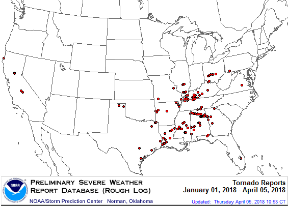
The lack of rainfall across the Plains also means there’s been a lack of severe weather this season. The middle of the country is usually teeming with severe weather by this point in the spring, but there’s been hardly anything to write home about so far. Most of the noteworthy severe weather this year has been confined to the southeast in states like Louisiana and Alabama.
The situation is so unusual that Oklahoma hasn’t seen any tornadoes so far in 2018. Tornadoes have come close to the state borders, as you can see on the SPC’s annual tornado reports map above, but there haven’t been any confirmed tornadoes in Oklahoma so far this year.
April 26 is the latest date Oklahoma has recorded its first tornado in any year since reliable tornado records began in 1950. The state is poised to blow past that record by at least a couple of days, possibly even longer if next week’s severe weather threat doesn’t pan out. However, as NWS Norman’s Rick Smith noted on Twitter, 2013 had an unusually late start as well and it turned out to spawn several devastating tornadoes in the state. A slow start doesn’t mean anything for later storms.
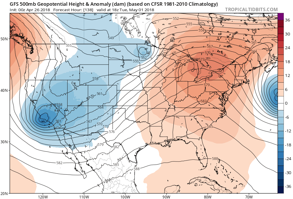
What’s to Come
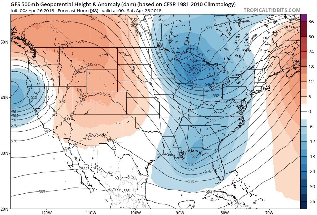
It looks likely that temperatures will warm back up to around normal east of the Rockies as we head into the first week of May. Models are showing a tendency for more ridging than troughing in the upper-levels of the atmosphere starting next week, which would allow temperatures to rise to the level worthy of air conditioning before too long. The change in patterns could also bring some temporary relief from the heat in the southwest and possibly lead to chances for severe thunderstorms in the middle of the country. Finer details for next week will come into view after we get through the weekend, but it looks like things will start to change as the last vestiges of winter finally seem willing to give up.
[Model Images: Tropical Tidbits | Tornado Map: SPC | Drought Map/Temp Graph: me]
Please consider subscribing to my writing on Patreon. Reader-funded journalism is more important than ever and your support helps fund engaging, hype-free weather coverage.

