A Short History of Short-Lived Tropical Storms
Tropical Storm Mindy formed and made landfall in about four hours on Wednesday afternoon. The system joins an interesting list of storms that spun up and came ashore with little notice. Here’s a very short history on these very sneaky storms.
Tropical Storm Mindy (2021)
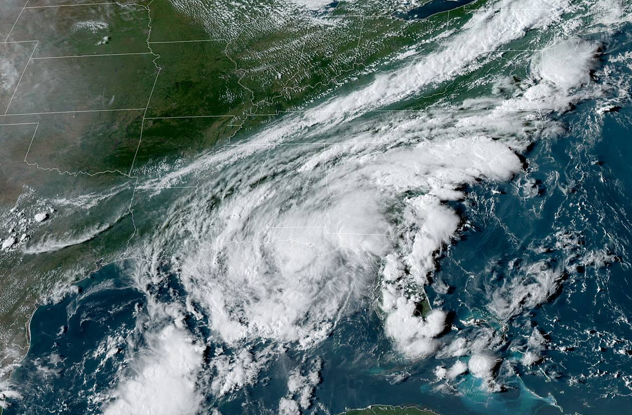
Mindy formed from a tropical disturbance we’ve been watching for more than a week. The disturbance first popped up in the National Hurricane Center’s tropical weather outlooks on August 30th, not long after Hurricane Ida made landfall in Louisiana.
The disturbance meandered over parts of Central America and Mexico before emerging over the Gulf of Mexico this past weekend. Forecasters upped the disturbance’s odds of development to 30% on Tuesday afternoon and to 60% on Wednesday afternoon.
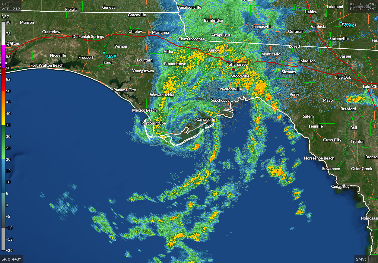 |
| Source: NOAA/Gibson Ridge |
The system developed a closed, well-defined circulation as it approached the Florida Panhandle on Wednesday afternoon. Forecasters declared the system Tropical Storm Mindy at 4:00 p.m., and the storm made landfall near Apalachicola just after 8:00 p.m.
Storms sometimes do that. It’s the peak of hurricane season and the Gulf of Mexico is warm. It doesn’t take much of a nudge to send a disturbance over the edge of formation when conditions are favorable for development.
Tropical Storm Bertha (2020)
Blink and you missed it. I don’t even have a graphic for it. It was just…there and gone. Bloop.
Tropical Storm Imelda (2019)
Forecasters declared a disturbance in the northwestern Gulf of Mexico a tropical depression at 12:00 p.m. The system became a tropical storm at 12:45 p.m. Imelda made landfall in Freeport, Texas, at 1:30 p.m.

While this was another hello/goodbye storm, the ensuing floods were well-predicted.
The remnants of Imelda stalled over parts of Texas and Louisiana and produced a tremendous amount of rain over the following days, with widespread totals of 12-24″+ common around and east of Houston, with totals approaching four feet (!!!) near Beaumont.
Tropical Storm Emily (2017)
Emily escalated quickly on July 31, 2017, as it swirled toward Florida’s west coast.
 |
| Source: NOAA/Gibson Ridge |
8:00 p.m.: 20% chance of formation.
2:00 a.m.: 40% chance of formation.
6:00 a.m.: Tropical Depression Six
8:00 a.m.: Tropical Storm Emily
11:10 a.m.: Landfall near Bradenton, Florida with 45 mph winds.
Tropical Storm Bill (2015)
The disturbance that became Tropical Storm Bill in June 2015 became a soap opera because of its expected wind and rain impacts in Texas as the storm took its time developing in the Gulf of Mexico.
“Are you a tropical storm?” pic.twitter.com/X1pfO3NsdJ
— Dennis Mersereau (@wxdam) June 16, 2015
It was obvious that the system would rapidly intensify as it approached the Texas coast, but it would happen just hours before it made landfall near Corpus Christi.
So we waited. And waited.
The disturbance finally developed into a tropical depression at 11:00 p.m. on June 15 and made landfall on Matagorda Island as a 60 mph tropical storm 12 hours later.
The bureaucratic headache that hampered the ability to issue forecasts for future-Bill was the reason we now get “potential tropical cyclones” every once and a while.
Forecasters at the National Hurricane Center came up with the PTC designation after Bill so the agency could issue advisories, watches, and warnings for a disturbance if it’s going to develop and hit quickly hit land soon after. Before then, we just had to wait and wait, which wasted critical time needed to get the word out to people in harm’s way.
Hurricane Humberto (2007)
 |
| Source: NHC |
One of the most memorable quicker-spinner-uppers was Hurricane Humberto in 2007. The system went from a tropical depression to a category one hurricane in about 24 hours, making landfall near Beaumont, Texas, with 85 mph winds.
The storm intensified into a hurricane 15 miles off the coast.
15 miles.
Humberto’s sudden jump in intensity wasn’t well predicted, and folks in the path of the storm had very little time to prepared for a full-fledged hurricane—which is less of a statement about the NHC’s abilities back in 2007 than it is about a tropical system’s ability to take off when it thrives over the Gulf of Mexico.
[Satellite Image: NOAA]
You can follow me on Twitter or send me an email.
Please consider subscribing to my Patreon. Your support helps me write engaging, hype-free weather coverage—no fretting over ad revenue, no chasing viral clicks. Just the weather.

