

Hurricane Lee remains a large and powerful storm south of Bermuda this evening as it begins the final stage of its weeks-long journey across the Atlantic Ocean.
The window for a harmless turn out to sea is closing in a hurry, likely locking in a period of hazardous weather for New England and the Canadian Maritimes this weekend.
Heavy rains, high winds, and coastal flooding will accompany the storm as it affects the region through Saturday and Sunday. While the storm’s precise track will determine where the greatest impacts unfold, Lee is a big storm and it’ll continue growing through the week, giving it a large reach as it pushes inland this weekend.
Lee is big and getting bigger
Hurricane Lee intensified into a category five storm late last week, becoming only the 29th hurricane to achieve this scale-topping feat since the satellite era began back in 1960.
The brevity of the storm’s peak was a testament to the fragile nature of these immense systems. A tiny bit of unexpected dry air and wind shear knocked Lee off balance not long after its peak, weakening its winds from 165 mph on Friday morning to ‘just’ 110 mph by Sunday morning.
A favorable environment in the southwestern Atlantic allowed the storm to recover, once again growing into a major hurricane south of Bermuda as it slowly begins marching north.
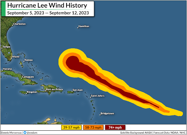
Hurricanes can use their energy in two ways. A storm can focus all its fury on a tiny section of the eyewall, or it can use that energy to expand its footprint and spread its winds over a very large area.
We can see Lee advancing in age by the way its wind field has grown since it first developed on September 5.
Lee is a very large hurricane now, with tropical storm force winds extending 240 miles away from the center of the storm. An uncrewed drone sailing into the storm measured a 92 mph wind gust 70 miles away from the center of the storm.
This wind field will continue to grow even as it weakens over the next few days as Lee pushes north toward New England and the Maritimes. Forecasters expect the storm to approach Maine and Nova Scotia at hurricane strength on Saturday.
New England and Canadian Maritimes are in the path
It’s looking less likely with time that Lee will make a right-hand turn out to sea, essentially assuring foul conditions for parts of New England, New Brunswick, Nova Scotia, and Prince Edward Island for much of this weekend.
The greatest uncertainty seems to be exactly what Lee does when it approaches the region. Forecasters and models both generally agree that Lee will continue pushing north through the remainder of the week, all while a cold front closes in on the storm from the west.
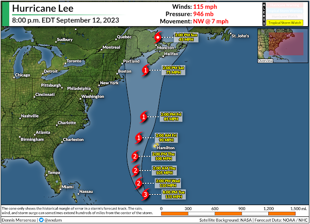
Eventually, the upper-level trough bringing the cooler, drier air over the East Coast will flex its influence over Lee and force it to transition from a hurricane into a storm that more closely resembles a nor’easter.
If the storm tracks a bit to the west, it would bring gustier winds and heavier rainfall into more populous sections of New England. A path farther east would keep the worst weather over the Maritime provinces.
It’s still four to five days out. Small changes in Lee’s track now will have big implications for its path later on. The bottom line is that folks throughout New England should keep a close eye on the storm and prepare now for a potentially rough spell of weather this weekend.
Prepare now so you’re not caught by surprise later
This isn’t going to be a blockbuster storm like Fiona or Dorian for the Maritimes, nor will it be a monstrous hurricane for New England.
That said, coastal communities in Maine are in for a steady dose of heavy rain, gusty winds, and a likely period of coastal flooding from storm surge and rough surf.
The latest forecast from the Weather Prediction Center calls for 2-4 inches of rain for much of eastern Maine, with heavier totals possible if the storm jogs a bit farther west than currently forecast. This could lead to localized flooding in vulnerable areas and in spots with poor drainage.

Given the storm’s growing footprint, gusty winds of 70+ mph seem likely along the coast, with decent gusts pushing farther inland depending on the storm’s ultimate track. The trees are still fully dressed in their summer best right now, so they’ll endure more stress than they would during a wintertime nor’easter.
Tree damage is likely in areas that see the strongest winds. Remain mindful of any trees or tree limbs that hang over your home. Trees falling into homes and vehicles is the leading cause of wind-related injury in a storm like this. Take the time to trim them if you can, and avoid rooms where trees may fall once the storm arrives.
At least some power outages are a pretty sure bet with winds this strong. Look around and make sure you’ve got enough supplies to last at least a couple days without power if needed.
Non-perishable food that doesn’t require cooking, water, personal hygiene supplies, and spare batteries are all a necessity.
Also—make sure you have actual flashlights! Your cell phone’s flashlight is a waste of a precious charge when the power goes out.
